


TrailStash
@trailstash.mapstodon.space.ap.brid.gy
Mapping projects by @dschep
🌉 bridged from ⁂ https://mapstodon.space/@trailstash, follow @ap.brid.gy to interact
🌉 bridged from ⁂ https://mapstodon.space/@trailstash, follow @ap.brid.gy to interact
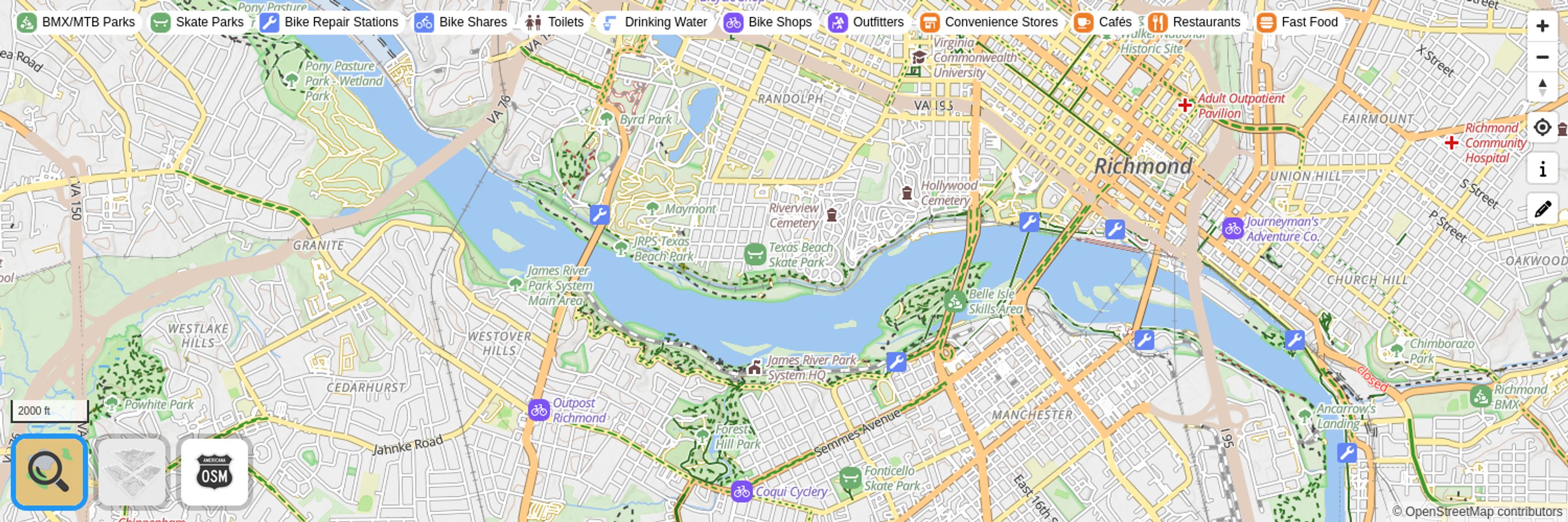
They have them at BikeWalkRVA/SportsBackers headquarters next to Bryan Park and I believe they'll be distribution them to local bike shops too.
September 4, 2025 at 3:35 PM
They have them at BikeWalkRVA/SportsBackers headquarters next to Bryan Park and I believe they'll be distribution them to local bike shops too.
This is resolved. Sorry for the inconvenience folks
July 24, 2025 at 2:28 PM
This is resolved. Sorry for the inconvenience folks
Another workaround: choose any non-OpenMapTiles styles. Those don't rely on styles.trailsta.sh which is what's broken.
July 21, 2025 at 12:17 AM
Another workaround: choose any non-OpenMapTiles styles. Those don't rely on styles.trailsta.sh which is what's broken.

@protomaps and the Protomaps styles are updated to directly use the Protomaps API (they already were using them for tiles) and updated to v4 styles.

protomaps (@protomaps@mapstodon.space)
102 Posts, 0 Following, 637 Followers · The world in a file. Open source!
mapstodon.space
April 5, 2025 at 2:02 AM
@protomaps and the Protomaps styles are updated to directly use the Protomaps API (they already were using them for tiles) and updated to v4 styles.
Reposted by TrailStash
Want to create a time series animation like the one @bmacs001 posted, but for your favorite region? The #osmwiki has the rudiments of a guide to creating one with {#overpassturbo or #overpassultra or #qlever} + #qgis + #ffmpeg:
https://wiki.openstreetmap.org/wiki/OpenHistoricalMap/QGIS
https://wiki.openstreetmap.org/wiki/OpenHistoricalMap/QGIS
OpenHistoricalMap/QGIS - OpenStreetMap Wiki
wiki.openstreetmap.org
March 6, 2025 at 5:06 PM
Want to create a time series animation like the one @bmacs001 posted, but for your favorite region? The #osmwiki has the rudiments of a guide to creating one with {#overpassturbo or #overpassultra or #qlever} + #qgis + #ffmpeg:
https://wiki.openstreetmap.org/wiki/OpenHistoricalMap/QGIS
https://wiki.openstreetmap.org/wiki/OpenHistoricalMap/QGIS
Reposted by TrailStash
Want the raw data? Here it is using #qlever and #overpassultra, exportable as #GeoJSON and in the #publicdomain […]
Original post on mapstodon.space
mapstodon.space
March 6, 2025 at 6:22 PM
Want the raw data? Here it is using #qlever and #overpassultra, exportable as #GeoJSON and in the #publicdomain […]