


Nelson Tucker
@tornadostudy.bsky.social
OTUS Project President. Millersville Meteorology 2026. Writer at Tornado Talk, NIST SURF 2024.
Reflecting on a truly wild, tornado-packed summer break with @otusproject.bsky.social to mark the beginning of year 23 on this planet!
youtu.be/kg7gywzHHD0?si…
youtu.be/kg7gywzHHD0?si…
August 26, 2025 at 4:02 PM
Reflecting on a truly wild, tornado-packed summer break with @otusproject.bsky.social to mark the beginning of year 23 on this planet!
youtu.be/kg7gywzHHD0?si…
youtu.be/kg7gywzHHD0?si…
Aftermath the next day. Home across street was outside scour strip, but core context was impressive with long grass destroyed at road rise. Dirt scour & cycloidal deposits at intercept zone (bottom right image). If recovered, we can get wind measurements from drone blackbox.


August 5, 2025 at 2:53 AM
Aftermath the next day. Home across street was outside scour strip, but core context was impressive with long grass destroyed at road rise. Dirt scour & cycloidal deposits at intercept zone (bottom right image). If recovered, we can get wind measurements from drone blackbox.
Saw a multi-vortex tornado this afternoon at Parmelee SD, had an @otusproject.bsky.social deployment on this
July 21, 2025 at 4:15 AM
Saw a multi-vortex tornado this afternoon at Parmelee SD, had an @otusproject.bsky.social deployment on this
One of our more eventful chases of the season… big day, and gearing up for tomorrow!


June 6, 2025 at 5:32 AM
One of our more eventful chases of the season… big day, and gearing up for tomorrow!
Tornado from a distance near North Platte, NE this evening on our @otusproject.bsky.social chase #newx
May 15, 2025 at 3:34 AM
Tornado from a distance near North Platte, NE this evening on our @otusproject.bsky.social chase #newx
If you care about the science or protecting life/property from weather hazards, please consider how you can lobby against this. What is proposed - if allowed - would be catastrophic and damage *every* part of modern meteorology.
www.science.org/content/arti...
www.eenews.net/articles/whi...
www.science.org/content/arti...
www.eenews.net/articles/whi...

April 11, 2025 at 10:20 PM
If you care about the science or protecting life/property from weather hazards, please consider how you can lobby against this. What is proposed - if allowed - would be catastrophic and damage *every* part of modern meteorology.
www.science.org/content/arti...
www.eenews.net/articles/whi...
www.science.org/content/arti...
www.eenews.net/articles/whi...
Several photos of a beautiful storm rolling through Millersville University, PA, near 3:40 am in the early morning hours of yesterday, March 4. Well worth staying up for! #pawx


April 5, 2025 at 7:30 PM
Several photos of a beautiful storm rolling through Millersville University, PA, near 3:40 am in the early morning hours of yesterday, March 4. Well worth staying up for! #pawx

First good storms of the year to time-lapse here at Millersville PA, man I’ve missed doing this!

March 31, 2025 at 9:40 PM
First good storms of the year to time-lapse here at Millersville PA, man I’ve missed doing this!
A McAllen, TX live webcam was getting a washing machine experience near a tornado warned circulation a few minutes ago:
#txwx
Livestreamed camera from Ruby Red Hospitality: www.youtube.com/live/la1nuQD...
#txwx
Livestreamed camera from Ruby Red Hospitality: www.youtube.com/live/la1nuQD...
March 27, 2025 at 8:33 PM
A McAllen, TX live webcam was getting a washing machine experience near a tornado warned circulation a few minutes ago:
#txwx
Livestreamed camera from Ruby Red Hospitality: www.youtube.com/live/la1nuQD...
#txwx
Livestreamed camera from Ruby Red Hospitality: www.youtube.com/live/la1nuQD...
2/2 video clip of storm.
March 24, 2025 at 4:39 PM
2/2 video clip of storm.
During our flight into Jackson MS the night of Mar 14 a supercell then producing a tornado near Belzoni put on a light show. Cabin was too well lit to crank the exposure up, but manually aligning and blending snapshots of the lightning flashes shows some of the storm structure. 1/2


March 24, 2025 at 4:38 PM
During our flight into Jackson MS the night of Mar 14 a supercell then producing a tornado near Belzoni put on a light show. Cabin was too well lit to crank the exposure up, but manually aligning and blending snapshots of the lightning flashes shows some of the storm structure. 1/2
Contrast-enhanced view of the Taylorsville, MS EF2 Tornado during our OTUS deployment on Sat 3/15. It was crossing MS Highway 37 and heading into town. CG lightning on some of these cells was the most intense I’ve been in. #mswx
March 19, 2025 at 1:41 AM
Contrast-enhanced view of the Taylorsville, MS EF2 Tornado during our OTUS deployment on Sat 3/15. It was crossing MS Highway 37 and heading into town. CG lightning on some of these cells was the most intense I’ve been in. #mswx
An amazing supercell thunderstorm developing near Akron, CO, on May 20, 2024.


March 9, 2025 at 6:55 PM
An amazing supercell thunderstorm developing near Akron, CO, on May 20, 2024.
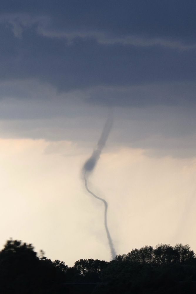
Funnel cloud on May 15, 2024, near Caldwell, KS just across the border in OK. We successfully deployed our OTUS drone system on this circulation.

February 13, 2025 at 6:27 PM
Funnel cloud on May 15, 2024, near Caldwell, KS just across the border in OK. We successfully deployed our OTUS drone system on this circulation.
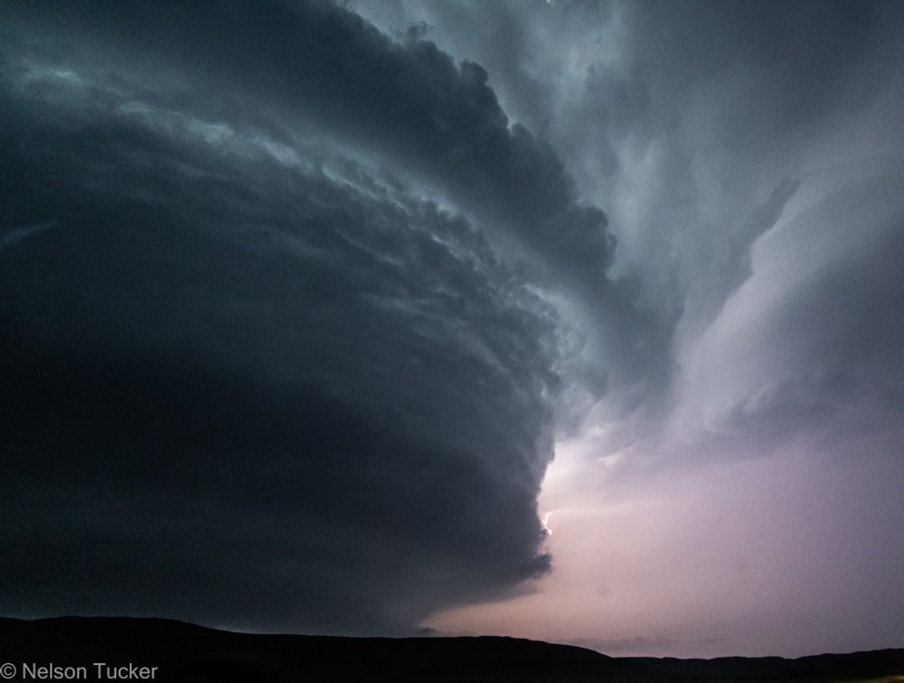
The barrel mesocyclone and whip-like subvortices of the forming Duke, OK tornado on May 23, 2024.


February 2, 2025 at 6:34 PM
The barrel mesocyclone and whip-like subvortices of the forming Duke, OK tornado on May 23, 2024.
Crushed wind turbines and churned ground along the path of a deadly tornado on May 21, 2024, that hit Greenfield, IA. This photo was taken about 1.5-2 hours later in northern Adams County.

January 31, 2025 at 11:15 PM
Crushed wind turbines and churned ground along the path of a deadly tornado on May 21, 2024, that hit Greenfield, IA. This photo was taken about 1.5-2 hours later in northern Adams County.
A long-lived supercell on May 25, 2024 near the OK/TX border, which earlier produced 2 tornadoes near Windthorst, TX. These photos were 2 hours apart.


January 29, 2025 at 4:10 PM
A long-lived supercell on May 25, 2024 near the OK/TX border, which earlier produced 2 tornadoes near Windthorst, TX. These photos were 2 hours apart.
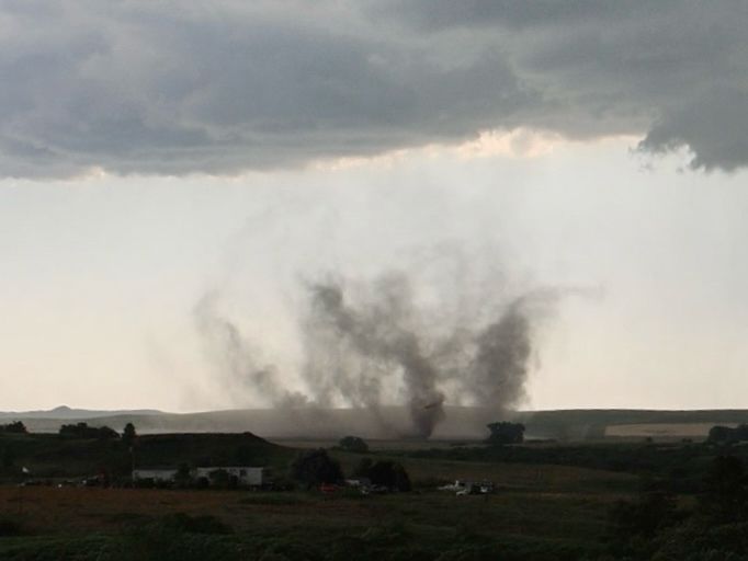
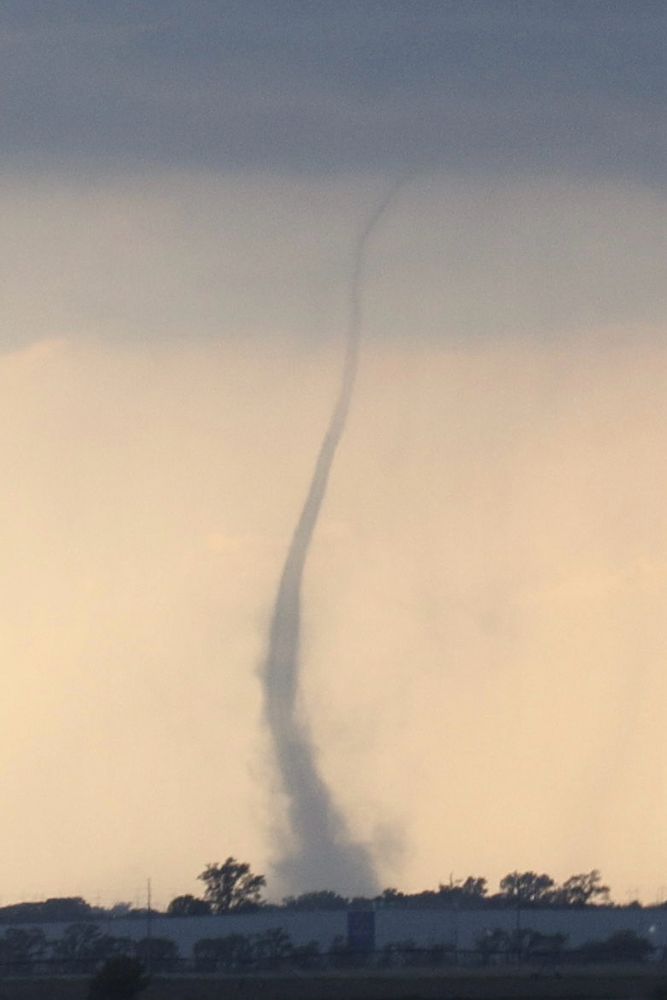
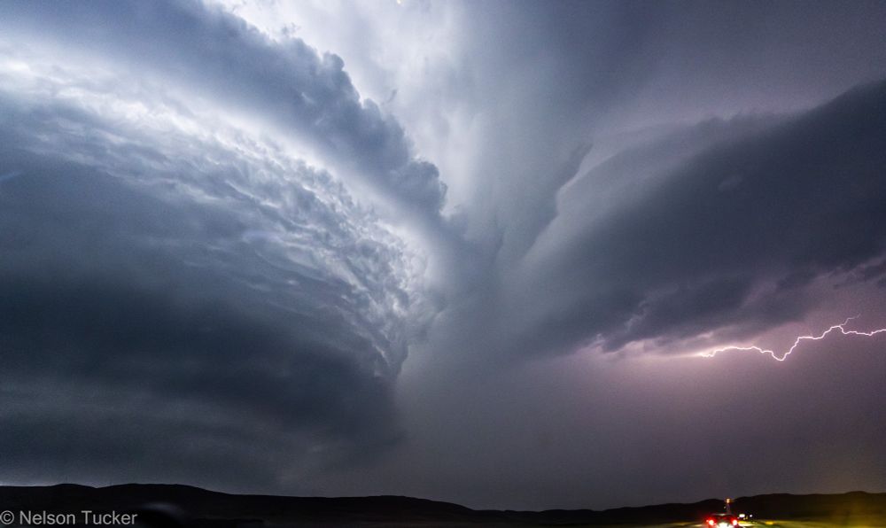
Photos of the Custer City, OK tornadic supercell structure on May 19, 2024.


January 27, 2025 at 4:47 PM
Photos of the Custer City, OK tornadic supercell structure on May 19, 2024.
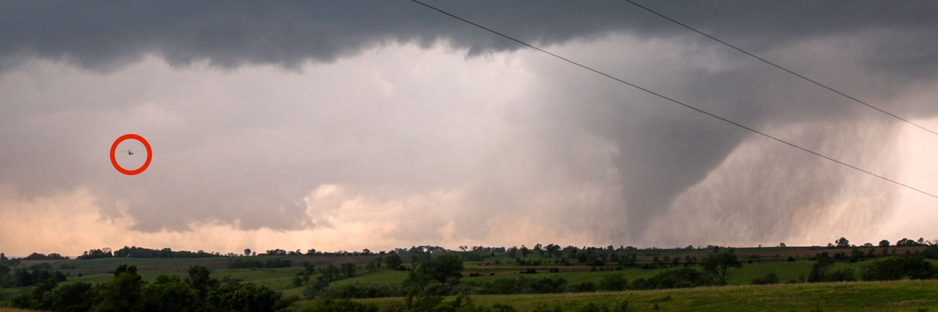
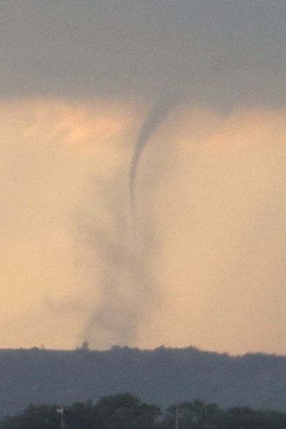
Video stills of the amazing helical rope-out of the May 21, 2024 Carbon, IA tornado, and of our OTUS Project fixed-wing UAV deploying on it.


January 27, 2025 at 2:56 AM
Video stills of the amazing helical rope-out of the May 21, 2024 Carbon, IA tornado, and of our OTUS Project fixed-wing UAV deploying on it.
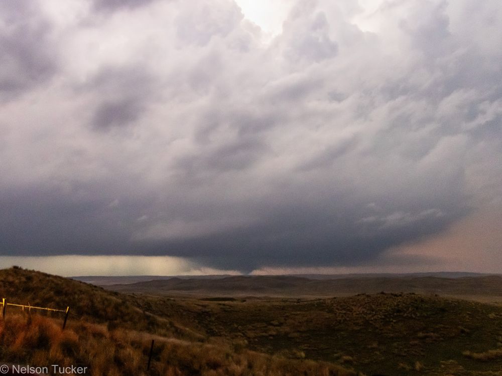
A developing supercell thunderstorm along the OK/KS border near Caldwell on May 15, 2024. This storm came close to producing a tornado shortly after.


January 25, 2025 at 7:18 PM
A developing supercell thunderstorm along the OK/KS border near Caldwell on May 15, 2024. This storm came close to producing a tornado shortly after.
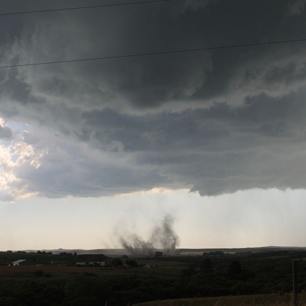
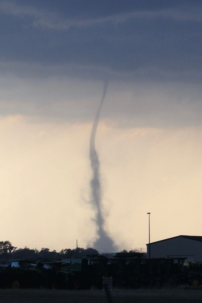
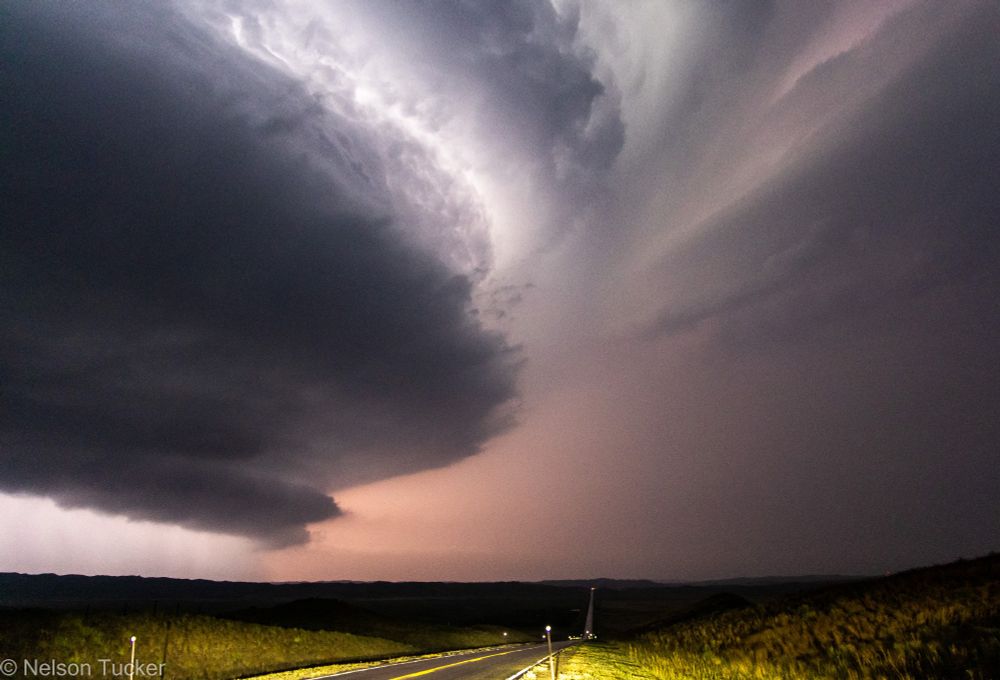
The massive, rain-wrapped Custer City, OK tornado on May 19, 2024. This is the first tornado that I directly saw and recognized, with several more occurring over the next few hours.

January 23, 2025 at 11:32 PM
The massive, rain-wrapped Custer City, OK tornado on May 19, 2024. This is the first tornado that I directly saw and recognized, with several more occurring over the next few hours.