


Antonio Vecoli (@tonyveco on X)
@tonyveco.bsky.social
#remotesensing @ https://bsky.app/profile/adamplatform.bsky.social
#Climate & #Copernicus Atmospheric Composition training for @eumetsat
@Esa ESAC 2014/15
Former #Copernicus 🇪🇺 Support Office /EMS/DEFIS
#Sentinerd S3B & S6A #Aeolus, #SolarOrbiter #MTGS1
#Climate & #Copernicus Atmospheric Composition training for @eumetsat
@Esa ESAC 2014/15
Former #Copernicus 🇪🇺 Support Office /EMS/DEFIS
#Sentinerd S3B & S6A #Aeolus, #SolarOrbiter #MTGS1
🔴⚠️🌀🇵🇭Ongoing scary landfall of #Fungwong on northern Aurora in Luzon,as a cat.4 Typhoon with gusts over 230km/h.More than 100000 evacuated and 400mm of rain so far,few days after #Kalmaegi.⬇️ Latest 6 hours by Himawari9 #ClimateEmergency #COP30 #Philippines
November 9, 2025 at 1:35 PM
🔴⚠️🌀🇵🇭Ongoing scary landfall of #Fungwong on northern Aurora in Luzon,as a cat.4 Typhoon with gusts over 230km/h.More than 100000 evacuated and 400mm of rain so far,few days after #Kalmaegi.⬇️ Latest 6 hours by Himawari9 #ClimateEmergency #COP30 #Philippines
🔴⚠️🌀🇵🇭After the devastating Kalmaegi,now #Fungwong is beating #Philippines again with winds at 200km/h.The cat.3 #Typhoon is reaching Luzon and yet affecting catanduanes.The Himawari9 animation of last 12hrs shows also mesovortices in the eye.#ClimateEmergency #UwanPH COP30
November 9, 2025 at 3:31 AM
🔴⚠️🌀🇵🇭After the devastating Kalmaegi,now #Fungwong is beating #Philippines again with winds at 200km/h.The cat.3 #Typhoon is reaching Luzon and yet affecting catanduanes.The Himawari9 animation of last 12hrs shows also mesovortices in the eye.#ClimateEmergency #UwanPH COP30
🔴⚠️🌀🇯🇲In the aftermath of hurricane #Melissa, the tropical vegetation of southwestern Jamaica has been devastated by the landfall at almost 300km/h.The first #Sentinel2 images after the event show the extreme consequences on BlackRiver and the wider area. #ClimateEmergency
November 5, 2025 at 2:53 AM
🔴⚠️🌀🇯🇲In the aftermath of hurricane #Melissa, the tropical vegetation of southwestern Jamaica has been devastated by the landfall at almost 300km/h.The first #Sentinel2 images after the event show the extreme consequences on BlackRiver and the wider area. #ClimateEmergency
🔴⚠️🌀🇯🇲With landfall in Cat.5, #Melissa is the strongest #hurricane to hit #Jamaica, with winds at almost 300km/h & first below 900mb in the Atlantic for the last 95 years. Stunning 📸#Sentinel2 of it with an eye of more than 20km on Oct.28

October 29, 2025 at 1:02 AM
🔴⚠️🌀🇯🇲With landfall in Cat.5, #Melissa is the strongest #hurricane to hit #Jamaica, with winds at almost 300km/h & first below 900mb in the Atlantic for the last 95 years. Stunning 📸#Sentinel2 of it with an eye of more than 20km on Oct.28
🔴⚠️🌀🇯🇲The third Cat.5 hurricane of the season,and yet one of 4 strongest ever in the Atlantic,#melissa keeps slowly moving westward with max winds at 280km/h according
@NHC_Atlantic
⬇️#GOES19 latest 12hrs with smaller eye after intensifying for hours. #ClimateEmergency
@NHC_Atlantic
⬇️#GOES19 latest 12hrs with smaller eye after intensifying for hours. #ClimateEmergency
October 28, 2025 at 1:17 AM
🔴⚠️🌀🇯🇲The third Cat.5 hurricane of the season,and yet one of 4 strongest ever in the Atlantic,#melissa keeps slowly moving westward with max winds at 280km/h according
@NHC_Atlantic
⬇️#GOES19 latest 12hrs with smaller eye after intensifying for hours. #ClimateEmergency
@NHC_Atlantic
⬇️#GOES19 latest 12hrs with smaller eye after intensifying for hours. #ClimateEmergency
🔴⚠️🌀🇯🇲In less than 6 hours, #Melissa has intensified as #Hurricane of Cat.4 with winds at 225km/h, yet threatening Jamaica with heavy rains even before the full impact on Monday.⬇️Latest 12hrs via @zoom_earth with cat4 monster at sunrise in the Caribbean. #ClimateEmergency pic.x.com/IV02PhMAkk
October 26, 2025 at 1:10 PM
🔴⚠️🌀🇯🇲In less than 6 hours, #Melissa has intensified as #Hurricane of Cat.4 with winds at 225km/h, yet threatening Jamaica with heavy rains even before the full impact on Monday.⬇️Latest 12hrs via @zoom_earth with cat4 monster at sunrise in the Caribbean. #ClimateEmergency pic.x.com/IV02PhMAkk
🔴⚠️🌀🏴🇮🇪UPDATE:Hundreds thousands of people with power outages in Ireland and N Ireland, winds at 180km/h in Scotland and 100km/h in N France.It's the stunning summary of #StormAmy in the last 24hrs⬇️From sunrise to sunset #Amy seen today by Meteosat12. #climateemergency
October 4, 2025 at 7:56 PM
🔴⚠️🌀🏴🇮🇪UPDATE:Hundreds thousands of people with power outages in Ireland and N Ireland, winds at 180km/h in Scotland and 100km/h in N France.It's the stunning summary of #StormAmy in the last 24hrs⬇️From sunrise to sunset #Amy seen today by Meteosat12. #climateemergency
🔴⚠️🌀🛰🏴🇮🇪The first atlantic #storm of the season has reached Europe on Oct.3.#StormAmy has hit #Ireland and #Scotland with gusts at 180km/h on the coasts now moving eastward affecting first #France with waves of 5m and then N. countries⬇️12hrs of #meteosat12 between 3-4 Oct.
October 4, 2025 at 8:39 AM
🔴⚠️🌀🛰🏴🇮🇪The first atlantic #storm of the season has reached Europe on Oct.3.#StormAmy has hit #Ireland and #Scotland with gusts at 180km/h on the coasts now moving eastward affecting first #France with waves of 5m and then N. countries⬇️12hrs of #meteosat12 between 3-4 Oct.
🔴 ⚠️ 🌀 ⛈️ 🛰️ The remnants of Hurricane #Gabrielle is an extra tropical cyclone that crossed the Atlantic reaching first Portugal, then hitting Spain where a red alert is ongoing for the Comunitat Valenciana. ⬇️ 36hrs for 27/28 Sept. by meteosat 12 #ClimateEmergency
September 28, 2025 at 11:08 PM
🔴 ⚠️ 🌀 ⛈️ 🛰️ The remnants of Hurricane #Gabrielle is an extra tropical cyclone that crossed the Atlantic reaching first Portugal, then hitting Spain where a red alert is ongoing for the Comunitat Valenciana. ⬇️ 36hrs for 27/28 Sept. by meteosat 12 #ClimateEmergency
🔴⚠️🌀🛰The second Cat.5 #Hurricane of the season after Erin in the Atlantic. #Humberto intensified in few hours reaching gusts at 310km/h with an 30km wide eye.The last back to back seasons with 2 Cat 5 Hurricanes was in the 1930s.⬇️Latest 10hrs by GOES19 IR. #climateemergency
September 28, 2025 at 1:29 AM
🔴⚠️🌀🛰The second Cat.5 #Hurricane of the season after Erin in the Atlantic. #Humberto intensified in few hours reaching gusts at 310km/h with an 30km wide eye.The last back to back seasons with 2 Cat 5 Hurricanes was in the 1930s.⬇️Latest 10hrs by GOES19 IR. #climateemergency
🔴⚠️🌀🇵🇭Super Typhoon #Ragasa is the strongest storm 2025,a cat.5 cyclone with gusts at 260km/h towards Babuyan islands where it could bring total distruction
.Its eye is 80km wide but increasing while getting stronger⬇️Himawary9 last 6hrs #climateemergency
.Its eye is 80km wide but increasing while getting stronger⬇️Himawary9 last 6hrs #climateemergency
September 22, 2025 at 12:16 AM
🔴⚠️🌀🇵🇭Super Typhoon #Ragasa is the strongest storm 2025,a cat.5 cyclone with gusts at 260km/h towards Babuyan islands where it could bring total distruction
.Its eye is 80km wide but increasing while getting stronger⬇️Himawary9 last 6hrs #climateemergency
.Its eye is 80km wide but increasing while getting stronger⬇️Himawary9 last 6hrs #climateemergency
🔴⚠️🔥Scary evolution of #GarnetFire that has reinforced on Sept. 7 ,growing from 36000 to 41000 acres in few hours and producing a large smoke plume moving northernwards with pyrocumulonimbus, as shown in the #Sentinel2 view of Sept.7. #climateemergency

September 8, 2025 at 6:51 PM
🔴⚠️🔥Scary evolution of #GarnetFire that has reinforced on Sept. 7 ,growing from 36000 to 41000 acres in few hours and producing a large smoke plume moving northernwards with pyrocumulonimbus, as shown in the #Sentinel2 view of Sept.7. #climateemergency
🔴 ⚠️ 🔥 🛰️ Few days after the end of the meteorological summer, the wildfire season was not over yet in the iberian peninsula: the new Fire Temperature RGB from MTG on #Eumetview shows the wide burn scars across Portugal and Spain also visualizing hotspots still active in the area ⬇️ 📸Sept.6 at 11UTC

September 8, 2025 at 2:36 PM
🔴 ⚠️ 🔥 🛰️ Few days after the end of the meteorological summer, the wildfire season was not over yet in the iberian peninsula: the new Fire Temperature RGB from MTG on #Eumetview shows the wide burn scars across Portugal and Spain also visualizing hotspots still active in the area ⬇️ 📸Sept.6 at 11UTC
🔴⚠️🔥♨️🇨🇦The latest heatwave in NW Canada has boosted again fast #wildfires, with more than 100 fires now in NorthwestTerritories. The town of FortProvidence is in danger and evacuated,close to 500km2 of burn scars⬇️Pyrocumulonimbus by #Sentinel2 on Aug 30 #climateemergency

September 1, 2025 at 2:28 AM
🔴⚠️🔥♨️🇨🇦The latest heatwave in NW Canada has boosted again fast #wildfires, with more than 100 fires now in NorthwestTerritories. The town of FortProvidence is in danger and evacuated,close to 500km2 of burn scars⬇️Pyrocumulonimbus by #Sentinel2 on Aug 30 #climateemergency
🔴⚠️🔥🇪🇸🇵🇹In the first cloud free day the view over N. Spain & Portugal is dramatic:burn scars span from Galicia to Extremadura & CastillayLeón down to Portugal, with hotspots still present.⬇️#Sentinel3 📸 of Aug.22 with FRP from eumetview. Wildfires #ClimateEmergency

August 23, 2025 at 11:06 AM
🔴⚠️🔥🇪🇸🇵🇹In the first cloud free day the view over N. Spain & Portugal is dramatic:burn scars span from Galicia to Extremadura & CastillayLeón down to Portugal, with hotspots still present.⬇️#Sentinel3 📸 of Aug.22 with FRP from eumetview. Wildfires #ClimateEmergency
🔴 ⚠️ ⛈️ ⚡ Severe storms with flash floods have affected N #Italy down to #Tuscany with widespread emergencies across all the provinces. More than 100K lightnings counted over the region during the storms. ⬇️meteosat-12 of 24hrs during the storms: GeoColor RGB + LI Accumulated Flash Area via #eumetview.
August 21, 2025 at 6:08 PM
🔴 ⚠️ ⛈️ ⚡ Severe storms with flash floods have affected N #Italy down to #Tuscany with widespread emergencies across all the provinces. More than 100K lightnings counted over the region during the storms. ⬇️meteosat-12 of 24hrs during the storms: GeoColor RGB + LI Accumulated Flash Area via #eumetview.
🔴 🔥 ♨️ ⚠️ Several days after their start, the large #wildfires affecting Portugal and Spain are still active, increasing their size and producing a massive quantity of smoke.⬇️meteosat-12📸 before sunset on Aug.20 showing most of the iberian peninsula covered by smoke,and engulfing Baleares

August 21, 2025 at 1:52 PM
🔴 🔥 ♨️ ⚠️ Several days after their start, the large #wildfires affecting Portugal and Spain are still active, increasing their size and producing a massive quantity of smoke.⬇️meteosat-12📸 before sunset on Aug.20 showing most of the iberian peninsula covered by smoke,and engulfing Baleares
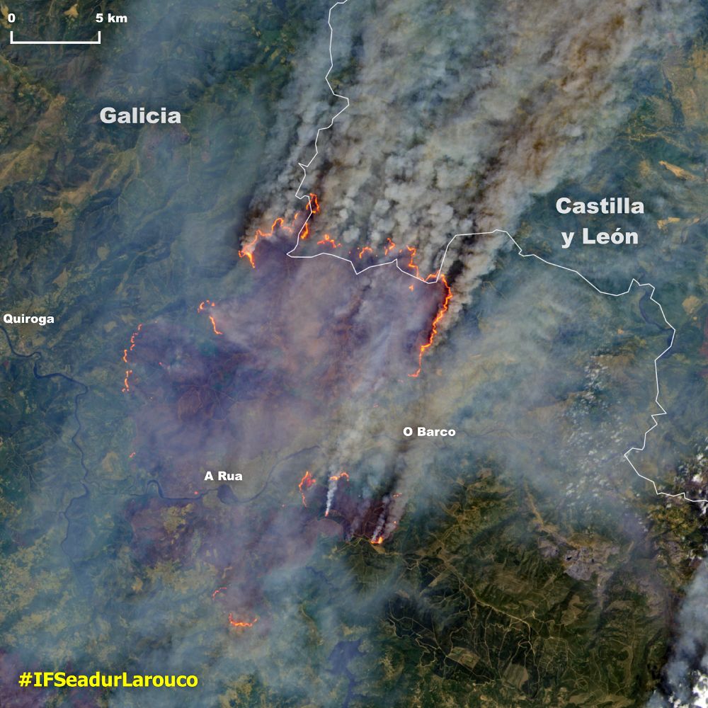
🔴⚠️🔥🇪🇸 Frightening evolution of #IFSeadurLarouco that has grown from 6000Ha to 15000Ha in 24hrs. This is the first 🛰️ Landsat - 8 📸 captured on August 17 and showing the pyrocumulonimbus developing from the the northern fire front along almost 20km. #Climateemergency
August 18, 2025 at 11:30 AM
🔴⚠️🔥🇪🇸 Frightening evolution of #IFSeadurLarouco that has grown from 6000Ha to 15000Ha in 24hrs. This is the first 🛰️ Landsat - 8 📸 captured on August 17 and showing the pyrocumulonimbus developing from the the northern fire front along almost 20km. #Climateemergency
🔴⚠️🌡️Hell is ongoing in #Spain where #wildfires are burning many thousands of hectares pushed by dry weather and strong winds. This #Sentinel2 📸shows the situation at the border of Galicia and Castilla y León,the most affected regions. with visible pyrocumulonimbus #climateemergency

August 16, 2025 at 10:36 PM
🔴⚠️🌡️Hell is ongoing in #Spain where #wildfires are burning many thousands of hectares pushed by dry weather and strong winds. This #Sentinel2 📸shows the situation at the border of Galicia and Castilla y León,the most affected regions. with visible pyrocumulonimbus #climateemergency
🔴 ⚠️ 🔥 ♨️ 🛰️ Many days with a persistent heatwave has strengthened the #wildifires season in the iberian peninsula. In Spain & Portugal violent fires are generating pyrocumulonimbous with massive smoke now engulfing W. France and reaching UK. ⬇️ Aerosol Index #Sentinel5P on Aug. 15 #ClimateEmergency

August 16, 2025 at 4:32 PM
🔴 ⚠️ 🔥 ♨️ 🛰️ Many days with a persistent heatwave has strengthened the #wildifires season in the iberian peninsula. In Spain & Portugal violent fires are generating pyrocumulonimbous with massive smoke now engulfing W. France and reaching UK. ⬇️ Aerosol Index #Sentinel5P on Aug. 15 #ClimateEmergency
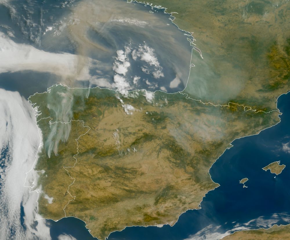
🔴⚠️🔥🇪🇸🇵🇹♨️An unprecedented massive smoke has reached W.#France from several burning #wildfires in #Spain and #Portugal. Dry weather & strong winds created a catastrophic scenario in the iberic peninsula.⬇️12hrs in daylight on Aug.15 by meteosat-12. #climateemergency
August 16, 2025 at 9:38 AM
🔴⚠️🔥🇪🇸🇵🇹♨️An unprecedented massive smoke has reached W.#France from several burning #wildfires in #Spain and #Portugal. Dry weather & strong winds created a catastrophic scenario in the iberic peninsula.⬇️12hrs in daylight on Aug.15 by meteosat-12. #climateemergency
🔴⚠️🔥🇪🇸🇵🇹🌡Alarming conditions for several #wildfires affecting Spain and Portugal since days.The latest meteosat-12 📸 in early August 15 shows a giant smoke plume flying over France as well as violent fires in the iberian peninsula. #climateemergency
August 15, 2025 at 1:24 PM
🔴⚠️🔥🇪🇸🇵🇹🌡Alarming conditions for several #wildfires affecting Spain and Portugal since days.The latest meteosat-12 📸 in early August 15 shows a giant smoke plume flying over France as well as violent fires in the iberian peninsula. #climateemergency
🔴⚠️🔥♨️Large parts of the iberian peninsula are engulfed by smoke.From Ourense and CastillayLeón to Extremadura in Spain,as well as Coimbra in Portugal:#wildfires with extreme 🌡 are out of control.#IncendiosForestales #ClimateEmergency ⬇️last 12hrs by meteosat-12 via @zoom.earth
August 14, 2025 at 5:43 PM
🔴⚠️🔥♨️Large parts of the iberian peninsula are engulfed by smoke.From Ourense and CastillayLeón to Extremadura in Spain,as well as Coimbra in Portugal:#wildfires with extreme 🌡 are out of control.#IncendiosForestales #ClimateEmergency ⬇️last 12hrs by meteosat-12 via @zoom.earth
🔴⚠️🔥Besides the 2nd worst year ever for wildfires in #Canada, records are also for temperatures in the eastern regions, including Newfoundland with 36.7°C on Aug 12 and an unusual fire burning since days across more than 6000Ha.⬇️#Sentinel2 📸of Aug.13 #climateemergency

August 14, 2025 at 12:22 AM
🔴⚠️🔥Besides the 2nd worst year ever for wildfires in #Canada, records are also for temperatures in the eastern regions, including Newfoundland with 36.7°C on Aug 12 and an unusual fire burning since days across more than 6000Ha.⬇️#Sentinel2 📸of Aug.13 #climateemergency
🔴⚠️🔥🇬🇷🇦🇱From #zante #Zakhyntos and #kefalonia to #Chios, islands and mainland #Patras, #Greece keeps burning and producing massive smoke that floats over the #mediterranean still with high temperatures.⬇️latest 12hrs by meteosat-12 via @zoom.earth #climateemergency
August 13, 2025 at 4:36 PM
🔴⚠️🔥🇬🇷🇦🇱From #zante #Zakhyntos and #kefalonia to #Chios, islands and mainland #Patras, #Greece keeps burning and producing massive smoke that floats over the #mediterranean still with high temperatures.⬇️latest 12hrs by meteosat-12 via @zoom.earth #climateemergency