


Tim Wright
@timwrightleeds.bsky.social
Prof of Satellite Geodesy, School of Earth and Env, Univ Leeds; Director of NERC_COMET; Co-founder of SatSenseLtd; @timwright_leeds on another site; Fringes, Quakes and some other stuff. All views my own.
Early days for this one, but doesn’t look like somewhere we’d associate with magma movement.
October 11, 2025 at 5:49 PM
Early days for this one, but doesn’t look like somewhere we’d associate with magma movement.
Yes - think so. The real power in the 2005 event (actually a sequence that continued to 2010) was magma moving into a volcanic dyke. The earthquakes were largely side effects.
October 11, 2025 at 5:48 PM
Yes - think so. The real power in the 2005 event (actually a sequence that continued to 2010) was magma moving into a volcanic dyke. The earthquakes were largely side effects.
Yes - that event was extraordinary. Hopefully this is not!
October 11, 2025 at 5:27 PM
Yes - that event was extraordinary. Hopefully this is not!
Yes. Looks like a moderate event on the fault that bounds the Afar depression. Will check in with our colleagues at Addis Ababa University.
October 11, 2025 at 5:20 PM
Yes. Looks like a moderate event on the fault that bounds the Afar depression. Will check in with our colleagues at Addis Ababa University.
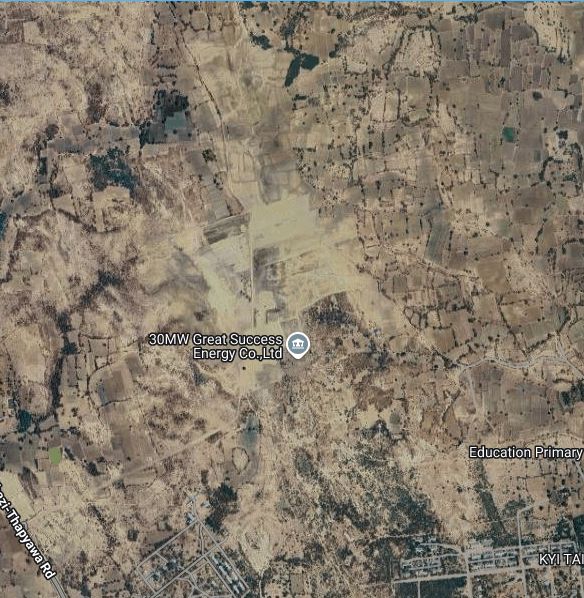
compound with the gates? If so then fault is more or less north-south?

May 13, 2025 at 3:54 PM
compound with the gates? If so then fault is more or less north-south?
I think this is it. The dark areas in the recent Sentinel-2 imagery are the solar panels.

May 13, 2025 at 3:49 PM
I think this is it. The dark areas in the recent Sentinel-2 imagery are the solar panels.
Maybe quite a lot of foreshortening based on aerial photo?
May 13, 2025 at 3:24 PM
Maybe quite a lot of foreshortening based on aerial photo?
Seems to be in a step-over zone from the imagery. If photo is to SSW, then that would make the rupture more or less north-south though? None of the satellite/openstreet map etc have the solar farm mapped to get a robust orientation as far as I can tell.
May 13, 2025 at 3:23 PM
Seems to be in a step-over zone from the imagery. If photo is to SSW, then that would make the rupture more or less north-south though? None of the satellite/openstreet map etc have the solar farm mapped to get a robust orientation as far as I can tell.
Data posted with ~100m pixels but actual resolution a little trickier to quantify as the input data for the 3D inversion is largely Sentinel-1 pixel tracking, but also includes some burst overlap interferometry. @mrnergizci.bsky.social might comment on detailed pixel tracking parameters
May 13, 2025 at 2:15 PM
Data posted with ~100m pixels but actual resolution a little trickier to quantify as the input data for the 3D inversion is largely Sentinel-1 pixel tracking, but also includes some burst overlap interferometry. @mrnergizci.bsky.social might comment on detailed pixel tracking parameters
The geotifs are available via the comet news article linked above.
May 13, 2025 at 2:10 PM
The geotifs are available via the comet news article linked above.
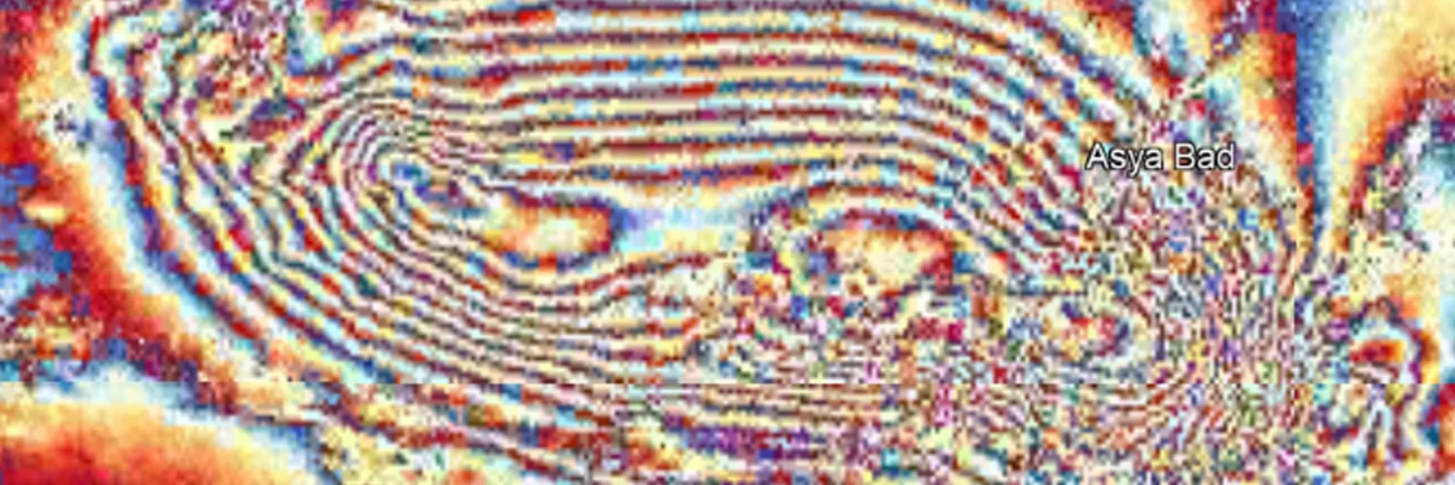
Comments in this video have it at 20°52'55.4"N 96°02'07.0"E www.youtube.com/watch?v=77ub... . Image shows location on COMET N-S displacements from Sentinel-1. About 3 m of overall displacement, but higher-res offset data would be good to get details.

May 13, 2025 at 8:28 AM
Comments in this video have it at 20°52'55.4"N 96°02'07.0"E www.youtube.com/watch?v=77ub... . Image shows location on COMET N-S displacements from Sentinel-1. About 3 m of overall displacement, but higher-res offset data would be good to get details.
Incredible. Been waiting a long time to see a surface rupture video. The rupture is pretty simple (single strand) so I'd guess it was the primary fault comet.nerc.ac.uk/myanmar-eart... . But there looks like a small stepover near Thazi? Anyone managed to get a fix on the exact location yet?

May 13, 2025 at 8:03 AM
Incredible. Been waiting a long time to see a surface rupture video. The rupture is pretty simple (single strand) so I'd guess it was the primary fault comet.nerc.ac.uk/myanmar-eart... . But there looks like a small stepover near Thazi? Anyone managed to get a fix on the exact location yet?
Sorry - our systems were not optimised for earthquakes of this scale. We have made some along-track mosaics available at gws-access.jasmin.ac.uk/public/nceo_... (e.g. gws-access.jasmin.ac.uk/public/nceo_...)

April 7, 2025 at 12:17 PM
Sorry - our systems were not optimised for earthquakes of this scale. We have made some along-track mosaics available at gws-access.jasmin.ac.uk/public/nceo_... (e.g. gws-access.jasmin.ac.uk/public/nceo_...)
Thanks to the Bristol students for organising

January 9, 2025 at 1:13 PM
Thanks to the Bristol students for organising