


Tim Buckley
@timbuckleywx.bsky.social
Chief Meteorologist at WFMY in Greensboro, NC. Weather, sports, food, nature photos, cats and random thoughts.
Penn Stater. College football should be played all year. Central NY born, but North Carolina is home now.
AMS CBM #552
Penn Stater. College football should be played all year. Central NY born, but North Carolina is home now.
AMS CBM #552


March 22, 2025 at 2:12 AM
WHAT'S THAT SMOKE?
A controlled burn to the south in the Uwharrie Forest is sending a smoke plume into the Triad right now.
You can see visibility is quite poor in High Point currently.
This could last an hour or two.
#ncwx
A controlled burn to the south in the Uwharrie Forest is sending a smoke plume into the Triad right now.
You can see visibility is quite poor in High Point currently.
This could last an hour or two.
#ncwx


March 12, 2025 at 9:09 PM
WHAT'S THAT SMOKE?
A controlled burn to the south in the Uwharrie Forest is sending a smoke plume into the Triad right now.
You can see visibility is quite poor in High Point currently.
This could last an hour or two.
#ncwx
A controlled burn to the south in the Uwharrie Forest is sending a smoke plume into the Triad right now.
You can see visibility is quite poor in High Point currently.
This could last an hour or two.
#ncwx

March 7, 2025 at 2:18 AM
Why is it so windy on this sunny day?
- Air flows from high pressure to low pressure
- We are caught in between a strong high and a strong low
- This creates a strong flow of air, which we call wind!
- Once high pressure shifts toward us tomorrow, winds will lessen #ncwx
- Air flows from high pressure to low pressure
- We are caught in between a strong high and a strong low
- This creates a strong flow of air, which we call wind!
- Once high pressure shifts toward us tomorrow, winds will lessen #ncwx

March 6, 2025 at 8:47 PM
Why is it so windy on this sunny day?
- Air flows from high pressure to low pressure
- We are caught in between a strong high and a strong low
- This creates a strong flow of air, which we call wind!
- Once high pressure shifts toward us tomorrow, winds will lessen #ncwx
- Air flows from high pressure to low pressure
- We are caught in between a strong high and a strong low
- This creates a strong flow of air, which we call wind!
- Once high pressure shifts toward us tomorrow, winds will lessen #ncwx
Wind reports from around the Piedmont today.
It will stay windy through Thursday.
It will stay windy through Thursday.

March 5, 2025 at 8:52 PM
Wind reports from around the Piedmont today.
It will stay windy through Thursday.
It will stay windy through Thursday.
8:50am - Heavy rain and gusty winds moving through. Severe tstorm warnings on this line right now. Wind gusts so far have been 40-50mph.
Most of this will be pushing through over the next hour and a half.
Hang tight and be alert for warnings. #ncwx
Most of this will be pushing through over the next hour and a half.
Hang tight and be alert for warnings. #ncwx

March 5, 2025 at 2:02 PM
8:50am - Heavy rain and gusty winds moving through. Severe tstorm warnings on this line right now. Wind gusts so far have been 40-50mph.
Most of this will be pushing through over the next hour and a half.
Hang tight and be alert for warnings. #ncwx
Most of this will be pushing through over the next hour and a half.
Hang tight and be alert for warnings. #ncwx
A nasty morning of storms and high winds is likely for North Carolina.
For our area, mainly 7am to 12pm. Especially 9-11am for the Greensboro area.
Low tornado threat. Gusty winds could bring power outages.
For our area, mainly 7am to 12pm. Especially 9-11am for the Greensboro area.
Low tornado threat. Gusty winds could bring power outages.


March 4, 2025 at 10:03 PM
A nasty morning of storms and high winds is likely for North Carolina.
For our area, mainly 7am to 12pm. Especially 9-11am for the Greensboro area.
Low tornado threat. Gusty winds could bring power outages.
For our area, mainly 7am to 12pm. Especially 9-11am for the Greensboro area.
Low tornado threat. Gusty winds could bring power outages.
You've probably seen all the "planetary parade" headlines.
We need to pump the brakes a little bit.
It will be a nice view but we're mainly only able to see Mars, Jupiter & Venus.
Saturn & Mercury will be a bit too low to see. Neptune & Uranus too dim.
Very clear sky tonight
We need to pump the brakes a little bit.
It will be a nice view but we're mainly only able to see Mars, Jupiter & Venus.
Saturn & Mercury will be a bit too low to see. Neptune & Uranus too dim.
Very clear sky tonight

February 28, 2025 at 9:14 PM
You've probably seen all the "planetary parade" headlines.
We need to pump the brakes a little bit.
It will be a nice view but we're mainly only able to see Mars, Jupiter & Venus.
Saturn & Mercury will be a bit too low to see. Neptune & Uranus too dim.
Very clear sky tonight
We need to pump the brakes a little bit.
It will be a nice view but we're mainly only able to see Mars, Jupiter & Venus.
Saturn & Mercury will be a bit too low to see. Neptune & Uranus too dim.
Very clear sky tonight
There may be a risk for severe weather next Wednesday in North Carolina.
We'll be on the edge of a cold front with a strong area of winds overhead in the jet stream. If thunderstorms can form, they'll bring high winds down to the ground.
Just watching for now. Details as we get closer. #ncwx
We'll be on the edge of a cold front with a strong area of winds overhead in the jet stream. If thunderstorms can form, they'll bring high winds down to the ground.
Just watching for now. Details as we get closer. #ncwx


February 27, 2025 at 9:44 PM
There may be a risk for severe weather next Wednesday in North Carolina.
We'll be on the edge of a cold front with a strong area of winds overhead in the jet stream. If thunderstorms can form, they'll bring high winds down to the ground.
Just watching for now. Details as we get closer. #ncwx
We'll be on the edge of a cold front with a strong area of winds overhead in the jet stream. If thunderstorms can form, they'll bring high winds down to the ground.
Just watching for now. Details as we get closer. #ncwx
IT'S BACK.... High levels of pollen observed across North Carolina today. Our local numbers collected in Forsyth County today show mostly Cedar tree and Elm tree pollen in the air at high levels. Tree pollen season has begun and will linger through April. #ncwx

February 25, 2025 at 8:44 PM
IT'S BACK.... High levels of pollen observed across North Carolina today. Our local numbers collected in Forsyth County today show mostly Cedar tree and Elm tree pollen in the air at high levels. Tree pollen season has begun and will linger through April. #ncwx
February has mostly either been spring or winter so far, with very little in between.
The rest of this week will be quite warm to finish out the month.
#ncwx
The rest of this week will be quite warm to finish out the month.
#ncwx

February 25, 2025 at 2:41 AM
February has mostly either been spring or winter so far, with very little in between.
The rest of this week will be quite warm to finish out the month.
#ncwx
The rest of this week will be quite warm to finish out the month.
#ncwx
Spring fever may be settling in this week.
We're not yet done with cold weather though.
We're not yet done with cold weather though.

February 24, 2025 at 9:42 PM
Spring fever may be settling in this week.
We're not yet done with cold weather though.
We're not yet done with cold weather though.
I combed over snow reports across the state from the two-day event this week.
This is a broad estimate of what fell.
The big winners were north and east in the state.
Here in the Triad, a lot of us were in the 1-2" range.
Many in the Foothills missed out on much. #ncwx #snow
This is a broad estimate of what fell.
The big winners were north and east in the state.
Here in the Triad, a lot of us were in the 1-2" range.
Many in the Foothills missed out on much. #ncwx #snow

February 21, 2025 at 9:39 PM

Why did your snow melt so quickly today?
You may not realize, but February sun is just as strong as October sun.
The sun angle is lowest in December, when we have our shortest days.
It's highest in June, when we have our longest days.
I've labeled the months that are "equal".
#ncwx
You may not realize, but February sun is just as strong as October sun.
The sun angle is lowest in December, when we have our shortest days.
It's highest in June, when we have our longest days.
I've labeled the months that are "equal".
#ncwx

February 20, 2025 at 11:09 PM
Why did your snow melt so quickly today?
You may not realize, but February sun is just as strong as October sun.
The sun angle is lowest in December, when we have our shortest days.
It's highest in June, when we have our longest days.
I've labeled the months that are "equal".
#ncwx
You may not realize, but February sun is just as strong as October sun.
The sun angle is lowest in December, when we have our shortest days.
It's highest in June, when we have our longest days.
I've labeled the months that are "equal".
#ncwx
Snow event is trending light and lighter for the Piedmont.
Just scattered snow showers may be possible at times on Wednesday, with another snow burst possible for the Thursday morning commute.
#ncwx
Just scattered snow showers may be possible at times on Wednesday, with another snow burst possible for the Thursday morning commute.
#ncwx


February 19, 2025 at 4:30 AM
Snow event is trending light and lighter for the Piedmont.
Just scattered snow showers may be possible at times on Wednesday, with another snow burst possible for the Thursday morning commute.
#ncwx
Just scattered snow showers may be possible at times on Wednesday, with another snow burst possible for the Thursday morning commute.
#ncwx
We're getting some snow Wednesday, but not a ton.
I have us in the 1 to 3 inch range, and this is some uncertainty.
Plan on slippery roads by lunchtime.
I have us in the 1 to 3 inch range, and this is some uncertainty.
Plan on slippery roads by lunchtime.


February 18, 2025 at 8:48 PM
We're getting some snow Wednesday, but not a ton.
I have us in the 1 to 3 inch range, and this is some uncertainty.
Plan on slippery roads by lunchtime.
I have us in the 1 to 3 inch range, and this is some uncertainty.
Plan on slippery roads by lunchtime.
First call map. Hate to "broad brush" things but I think 1-3" is as specific as I can go for the Triad right now. I'll add categories tomorrow.
We're on the edge of drier air to the west. Lower amounts west, higher amounts east. Shifts still possible in either direction.
Timing attached. #ncwx
We're on the edge of drier air to the west. Lower amounts west, higher amounts east. Shifts still possible in either direction.
Timing attached. #ncwx


February 18, 2025 at 1:01 AM
First call map. Hate to "broad brush" things but I think 1-3" is as specific as I can go for the Triad right now. I'll add categories tomorrow.
We're on the edge of drier air to the west. Lower amounts west, higher amounts east. Shifts still possible in either direction.
Timing attached. #ncwx
We're on the edge of drier air to the west. Lower amounts west, higher amounts east. Shifts still possible in either direction.
Timing attached. #ncwx
A winter storm will move into North Carolina Wednesday morning, ending Thursday morning.
As of now, we expect mainly snow north of I-40 with a mix of snow, sleet and ice south of that.
This map is not amounts, which we'll narrow down tomorrow.
Significant impacts are likely.
#ncwx
As of now, we expect mainly snow north of I-40 with a mix of snow, sleet and ice south of that.
This map is not amounts, which we'll narrow down tomorrow.
Significant impacts are likely.
#ncwx


February 16, 2025 at 8:58 PM
A winter storm will move into North Carolina Wednesday morning, ending Thursday morning.
As of now, we expect mainly snow north of I-40 with a mix of snow, sleet and ice south of that.
This map is not amounts, which we'll narrow down tomorrow.
Significant impacts are likely.
#ncwx
As of now, we expect mainly snow north of I-40 with a mix of snow, sleet and ice south of that.
This map is not amounts, which we'll narrow down tomorrow.
Significant impacts are likely.
#ncwx
A nasty Sunday with a line of heavy rain / storms between 7am - 10am.
Gusty winds of 40+ mph are possible anytime through the day.
Gusty winds of 40+ mph are possible anytime through the day.


February 16, 2025 at 2:35 AM
A nasty Sunday with a line of heavy rain / storms between 7am - 10am.
Gusty winds of 40+ mph are possible anytime through the day.
Gusty winds of 40+ mph are possible anytime through the day.
This is an early look, but as of now I think most of NC needs to be on guard for an impactful mix of snow, sleet and freezing rain.
Some areas could get an ice storm out of this.
Better chances for snow north, lower chances south.
Will narrow down as we get closer.
#ncwx
Some areas could get an ice storm out of this.
Better chances for snow north, lower chances south.
Will narrow down as we get closer.
#ncwx

February 15, 2025 at 10:20 PM
This is an early look, but as of now I think most of NC needs to be on guard for an impactful mix of snow, sleet and freezing rain.
Some areas could get an ice storm out of this.
Better chances for snow north, lower chances south.
Will narrow down as we get closer.
#ncwx
Some areas could get an ice storm out of this.
Better chances for snow north, lower chances south.
Will narrow down as we get closer.
#ncwx
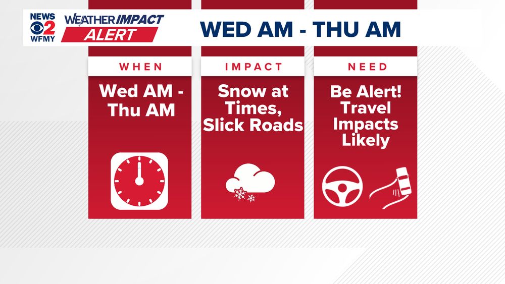
Yes, winter weather is possible again in North Carolina.
We're highlighting Wednesday into Thursday right now.
Likely to be a mixed bag of snow, ice, and rain across the state.
Many of us will get a messy combo.
Significant impacts possible.
STORY: www.wfmynews2.com/article/news...
We're highlighting Wednesday into Thursday right now.
Likely to be a mixed bag of snow, ice, and rain across the state.
Many of us will get a messy combo.
Significant impacts possible.
STORY: www.wfmynews2.com/article/news...


February 15, 2025 at 3:18 AM
Yes, winter weather is possible again in North Carolina.
We're highlighting Wednesday into Thursday right now.
Likely to be a mixed bag of snow, ice, and rain across the state.
Many of us will get a messy combo.
Significant impacts possible.
STORY: www.wfmynews2.com/article/news...
We're highlighting Wednesday into Thursday right now.
Likely to be a mixed bag of snow, ice, and rain across the state.
Many of us will get a messy combo.
Significant impacts possible.
STORY: www.wfmynews2.com/article/news...
Enjoy tomorrow. It will be sunny, but cool.
The weekend will be wet. Saturday will be cold and dreary with on and off rain. Sunday will have morning rain and t-storms. Very gusty winds.
We need to watch the Wed-Thu timeframe next week for another possible winter event. Too early for details. #ncwx
The weekend will be wet. Saturday will be cold and dreary with on and off rain. Sunday will have morning rain and t-storms. Very gusty winds.
We need to watch the Wed-Thu timeframe next week for another possible winter event. Too early for details. #ncwx

February 13, 2025 at 9:36 PM
Enjoy tomorrow. It will be sunny, but cool.
The weekend will be wet. Saturday will be cold and dreary with on and off rain. Sunday will have morning rain and t-storms. Very gusty winds.
We need to watch the Wed-Thu timeframe next week for another possible winter event. Too early for details. #ncwx
The weekend will be wet. Saturday will be cold and dreary with on and off rain. Sunday will have morning rain and t-storms. Very gusty winds.
We need to watch the Wed-Thu timeframe next week for another possible winter event. Too early for details. #ncwx