


Texas Storm Chasers
@texasstormchasers.com
Get your local forecasts, weather articles, and video forecasts from the Texas Storm Chasers, along with interactive weather radar in TSC's Mobile App.
The chances of above-average precipitation over the days preceding Thanksgiving (11/22-11/26) are maxed out over #Texas! Rounds of rain and storms are coming, looking to start in earnest this Thursday. -Jason/TSC

November 17, 2025 at 2:17 AM
The chances of above-average precipitation over the days preceding Thanksgiving (11/22-11/26) are maxed out over #Texas! Rounds of rain and storms are coming, looking to start in earnest this Thursday. -Jason/TSC
We will be POOL READY in Texas tomorrow! Here are forecast high temps for 11/17. Flirting with 90 in North & Central Texas.
~Jason/TSC
~Jason/TSC

November 16, 2025 at 10:48 PM
We will be POOL READY in Texas tomorrow! Here are forecast high temps for 11/17. Flirting with 90 in North & Central Texas.
~Jason/TSC
~Jason/TSC
A shift in the weather pattern next week could finally bring better rain chances across much of Texas between November 19–23. 🌧️ I'll believe it when I see it! ~David
#TXwx #TexasWeather #Rain #Forecast #Texas
#TXwx #TexasWeather #Rain #Forecast #Texas

November 13, 2025 at 8:42 PM
A shift in the weather pattern next week could finally bring better rain chances across much of Texas between November 19–23. 🌧️ I'll believe it when I see it! ~David
#TXwx #TexasWeather #Rain #Forecast #Texas
#TXwx #TexasWeather #Rain #Forecast #Texas
BREAKING: G4 storm levels reached as a major geomagnetic storm begins! Northern lights are visible with cameras and even to the naked eye across the northern part of Texas at 7:40Pm.

November 12, 2025 at 1:42 AM
BREAKING: G4 storm levels reached as a major geomagnetic storm begins! Northern lights are visible with cameras and even to the naked eye across the northern part of Texas at 7:40Pm.
11/11 3PM: On fire watch this afternoon with two ‘hotspots’ (wildfires) detected at the moment. One fire is east of Junction; and a second fire is east of Brackettville on Highway 90. Wildfire info at tfsincidents.com or via Watch Duty. #TXfire

November 11, 2025 at 9:02 PM
11/11 3PM: On fire watch this afternoon with two ‘hotspots’ (wildfires) detected at the moment. One fire is east of Junction; and a second fire is east of Brackettville on Highway 90. Wildfire info at tfsincidents.com or via Watch Duty. #TXfire
WOW! Lakes across Texas are showing up as ‘hotspots’ on infrared satellite imagery tonight because the warmer waters in a cool airmass. Science is cool! #TXwx

November 11, 2025 at 3:03 AM
WOW! Lakes across Texas are showing up as ‘hotspots’ on infrared satellite imagery tonight because the warmer waters in a cool airmass. Science is cool! #TXwx
CHILLY MORNING AHEAD... Temperatures will dip down into the upper 20s and lower 30s in the FREEZE WARNING area, resulting in the coldest morning of the season for many folks. Be sure to bundle up, and be mindful of pets and plants that are outside

November 10, 2025 at 3:58 AM
CHILLY MORNING AHEAD... Temperatures will dip down into the upper 20s and lower 30s in the FREEZE WARNING area, resulting in the coldest morning of the season for many folks. Be sure to bundle up, and be mindful of pets and plants that are outside
Critical fire danger Sunday across Central, South & Southeast Texas. 🔥
Low humidity + strong winds = fast-spreading fires. Avoid outdoor burning & anything that sparks.
#TXwx #FireWeather #Texas #WildfireRisk #BurnBan
Low humidity + strong winds = fast-spreading fires. Avoid outdoor burning & anything that sparks.
#TXwx #FireWeather #Texas #WildfireRisk #BurnBan

November 8, 2025 at 9:56 PM
Critical fire danger Sunday across Central, South & Southeast Texas. 🔥
Low humidity + strong winds = fast-spreading fires. Avoid outdoor burning & anything that sparks.
#TXwx #FireWeather #Texas #WildfireRisk #BurnBan
Low humidity + strong winds = fast-spreading fires. Avoid outdoor burning & anything that sparks.
#TXwx #FireWeather #Texas #WildfireRisk #BurnBan
Take a look at this morning's satellite loop! Witness the low-level stratus and fog gradually clearing away across the Brazos Valley, Southeast Texas, and near the Texas Gulf Coast. Beautiful morning skies in motion! #TXwx
November 8, 2025 at 4:48 PM
Take a look at this morning's satellite loop! Witness the low-level stratus and fog gradually clearing away across the Brazos Valley, Southeast Texas, and near the Texas Gulf Coast. Beautiful morning skies in motion! #TXwx
The blue colors indicate air temperatures at or below freezing Monday morning. Cover those plants if that includes you! Wind chills will feel even colder.

November 8, 2025 at 2:45 PM
The blue colors indicate air temperatures at or below freezing Monday morning. Cover those plants if that includes you! Wind chills will feel even colder.
It's a lovely day here in Houston, and what a beautiful day across Texas! Badly-in-Chief David Reimer is at the Disasters Expo USA—it's always wonderful to reconnect with new learning opportunities and build partnerships.


November 5, 2025 at 9:57 PM
It's a lovely day here in Houston, and what a beautiful day across Texas! Badly-in-Chief David Reimer is at the Disasters Expo USA—it's always wonderful to reconnect with new learning opportunities and build partnerships.
Daylight Savings Time ENDS TONIGHT! Clocks will turn back one hour jumping from 2 AM to 1 AM. An hour of extra sleep will be unlocked. BUT this means the sunset will occur before 6 PM tomorrow in #Texas!

November 1, 2025 at 6:16 PM
Daylight Savings Time ENDS TONIGHT! Clocks will turn back one hour jumping from 2 AM to 1 AM. An hour of extra sleep will be unlocked. BUT this means the sunset will occur before 6 PM tomorrow in #Texas!
Happy Saturday! This afternoon and evening, there's an increased hail storm risk across the Coastal Plains, Coastal Bend, and Rio Grande Valley due to a cold front. Storms are likely between 3 PM and midnight, moving into the Gulf tonight. Tornadoes are unlikely. ~David #TXwx

November 1, 2025 at 4:34 PM
Happy Saturday! This afternoon and evening, there's an increased hail storm risk across the Coastal Plains, Coastal Bend, and Rio Grande Valley due to a cold front. Storms are likely between 3 PM and midnight, moving into the Gulf tonight. Tornadoes are unlikely. ~David #TXwx
Happy November, holiday season is upon us. With that comes longer nights. Here is how much daylight we lose throughout #Texas by the end of the month.

November 1, 2025 at 3:02 PM
Happy November, holiday season is upon us. With that comes longer nights. Here is how much daylight we lose throughout #Texas by the end of the month.
A cold front will promote storm development in SE Texas later today. Some storms may be severe with a low risk for all hazards.
Stay weather aware — and remember, if tornado warnings are issued, we’ll have live coverage.
Detailed forecast: www.texasweatherroundup.video
Stay weather aware — and remember, if tornado warnings are issued, we’ll have live coverage.
Detailed forecast: www.texasweatherroundup.video

October 28, 2025 at 6:32 PM
A cold front will promote storm development in SE Texas later today. Some storms may be severe with a low risk for all hazards.
Stay weather aware — and remember, if tornado warnings are issued, we’ll have live coverage.
Detailed forecast: www.texasweatherroundup.video
Stay weather aware — and remember, if tornado warnings are issued, we’ll have live coverage.
Detailed forecast: www.texasweatherroundup.video
It is time for Freeze Watch graphics! The watch region indicates a potential for freezing temperatures on Wednesday morning. How are we feeling about this colder air coming into Texas tomorrow night?

October 27, 2025 at 8:34 PM
It is time for Freeze Watch graphics! The watch region indicates a potential for freezing temperatures on Wednesday morning. How are we feeling about this colder air coming into Texas tomorrow night?
10/25 944PM: No news is good news; rain persists over Brazos Valley, East Texas, and will move SE across Southeast Texas. Severe risk isn’t zero, but no recent issues. Monitoring for rogue storms near Upper Texas Coast. #txwx
October 26, 2025 at 2:47 AM
10/25 944PM: No news is good news; rain persists over Brazos Valley, East Texas, and will move SE across Southeast Texas. Severe risk isn’t zero, but no recent issues. Monitoring for rogue storms near Upper Texas Coast. #txwx
TODAY: We have a Slight Risk of severe weather extending from Central Texas to Southeast Texas as additional storms should fire up by mid-afternoon moving from west to east. Everyone in the risk region stay weather aware today/tonight!
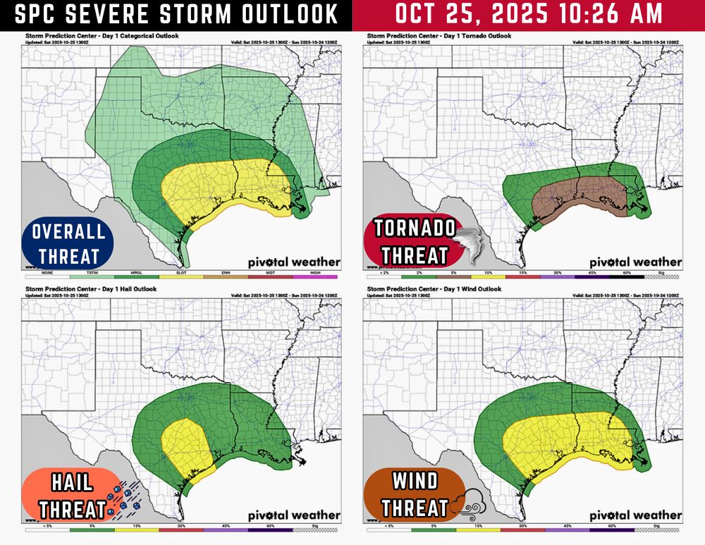
October 25, 2025 at 3:39 PM
TODAY: We have a Slight Risk of severe weather extending from Central Texas to Southeast Texas as additional storms should fire up by mid-afternoon moving from west to east. Everyone in the risk region stay weather aware today/tonight!
Another Severe Thunderstorm Watch has been issued, and this one is for #Houston and Southeast #Texas until 7 AM CDT 10/25. As the storm complex moves through from west to east it will bring scattered damaging wind gusts and sporadic hail. An isolated brief spin-up cannot be ruled out. #TxWx

October 25, 2025 at 6:55 AM
1:59 PM — Large hail is moving into FORT DAVIS, TX now! May be half-dollar size. Wind gusts up to 60 MPH.

October 24, 2025 at 7:05 PM
1:59 PM — Large hail is moving into FORT DAVIS, TX now! May be half-dollar size. Wind gusts up to 60 MPH.
1:23 PM - A Flash Flood Warning has been issued for the ODESSA area (Ector and Midland Counties). Approx 1-2” of rain per hour ongoing ☔️

October 24, 2025 at 6:27 PM
1:23 PM - A Flash Flood Warning has been issued for the ODESSA area (Ector and Midland Counties). Approx 1-2” of rain per hour ongoing ☔️
10/24 1:10PM - Damaging winds moving east/northeast into Odessa. Could impact Midland by 1:35 PM. Heads up! LIVE UPDATES: texasstormchasers.com/live

October 24, 2025 at 6:10 PM
10/24 1:10PM - Damaging winds moving east/northeast into Odessa. Could impact Midland by 1:35 PM. Heads up! LIVE UPDATES: texasstormchasers.com/live
10/24 12:15PM - Severe thunderstorms are expected to intensify this afternoon across West Texas, the Permian Basin, and the Big Bend. A Severe Thunderstorm Watch is in effect until 7 PM CT for areas including the Big Bend, Permian Basin, Concho Valley, Big Country, and West Texas.

October 24, 2025 at 5:17 PM
10/24 12:15PM - Severe thunderstorms are expected to intensify this afternoon across West Texas, the Permian Basin, and the Big Bend. A Severe Thunderstorm Watch is in effect until 7 PM CT for areas including the Big Bend, Permian Basin, Concho Valley, Big Country, and West Texas.
Good morning, y’all. Here are the updated infographics highlighting the overall severe weather and flash flooding potential today and tomorrow in Texas:


October 24, 2025 at 3:17 PM
Good morning, y’all. Here are the updated infographics highlighting the overall severe weather and flash flooding potential today and tomorrow in Texas: