


Jason Cooley
@stormserenader.bsky.social
Meteorologist, Storm Tracker, Musician, Father 3X. U of Oklahoma Alum. I track storms for Texas Storm Chasers and KTEN. Views expressed are my own and do not represent any organization or group I work with. Creator of Cool-E Road Trips. #PutitDownforAbbie
Still doing this! Above-average heat will continue to dominate the eastern 2/3rds of the nation into early next week. There are signs of a big cool down after that, but prepare for a stretch of toasty days until then. The western third of the country feels more Fall-like though!

October 6, 2025 at 4:06 PM
Still doing this! Above-average heat will continue to dominate the eastern 2/3rds of the nation into early next week. There are signs of a big cool down after that, but prepare for a stretch of toasty days until then. The western third of the country feels more Fall-like though!
A widespread frost/freeze is coming soon to the northwest US! While the eastern half of the country basks in warmth, colder air will be on the way to the western half around October 4th-6th.

September 30, 2025 at 4:17 PM
A widespread frost/freeze is coming soon to the northwest US! While the eastern half of the country basks in warmth, colder air will be on the way to the western half around October 4th-6th.
Beginning October on the warm side!
Here is the mid-range temperature outlook for October 5th-9th, highlighting above-average temps LIKELY across the eastern 2/3rds of the country. Toasty for this time of year in the Midwest to Northeast! Cooler trends coming in for the western third of the US!
Here is the mid-range temperature outlook for October 5th-9th, highlighting above-average temps LIKELY across the eastern 2/3rds of the country. Toasty for this time of year in the Midwest to Northeast! Cooler trends coming in for the western third of the US!

September 29, 2025 at 8:15 PM
Beginning October on the warm side!
Here is the mid-range temperature outlook for October 5th-9th, highlighting above-average temps LIKELY across the eastern 2/3rds of the country. Toasty for this time of year in the Midwest to Northeast! Cooler trends coming in for the western third of the US!
Here is the mid-range temperature outlook for October 5th-9th, highlighting above-average temps LIKELY across the eastern 2/3rds of the country. Toasty for this time of year in the Midwest to Northeast! Cooler trends coming in for the western third of the US!
A tornado watch has been issued for parts of Arkansas and Oklahoma until 10 PM CDT!

September 23, 2025 at 8:08 PM
A tornado watch has been issued for parts of Arkansas and Oklahoma until 10 PM CDT!
9/22: Lots of severe weather risk today/tonight in the US
The autumnal equinox is here and so is the chance for more severe storms across the country. Details on hazards and their locations in graphic:
The autumnal equinox is here and so is the chance for more severe storms across the country. Details on hazards and their locations in graphic:

September 22, 2025 at 6:45 PM
9/22: Lots of severe weather risk today/tonight in the US
The autumnal equinox is here and so is the chance for more severe storms across the country. Details on hazards and their locations in graphic:
The autumnal equinox is here and so is the chance for more severe storms across the country. Details on hazards and their locations in graphic:
Cat-5 Super Typhoon #Ragasa is bearing down on the Batones and Babuyan Islands in the west Pacific in the far northern Phillipines. Here is a look from the ISS. China also in the crosshairs later this week. Yikes!

September 21, 2025 at 3:56 PM
Cat-5 Super Typhoon #Ragasa is bearing down on the Batones and Babuyan Islands in the west Pacific in the far northern Phillipines. Here is a look from the ISS. China also in the crosshairs later this week. Yikes!
Got more than I bargained for
I was chasing this storm in Rosebud, Texas on April 12, 2022 and its hail core suddenly shifted direction, causing me to get inside a barrage of baseballs. It wasn’t my favorite, but it happens when you get aggressive in this line of work! #stormchasing
I was chasing this storm in Rosebud, Texas on April 12, 2022 and its hail core suddenly shifted direction, causing me to get inside a barrage of baseballs. It wasn’t my favorite, but it happens when you get aggressive in this line of work! #stormchasing
August 10, 2025 at 7:10 PM
Got more than I bargained for
I was chasing this storm in Rosebud, Texas on April 12, 2022 and its hail core suddenly shifted direction, causing me to get inside a barrage of baseballs. It wasn’t my favorite, but it happens when you get aggressive in this line of work! #stormchasing
I was chasing this storm in Rosebud, Texas on April 12, 2022 and its hail core suddenly shifted direction, causing me to get inside a barrage of baseballs. It wasn’t my favorite, but it happens when you get aggressive in this line of work! #stormchasing
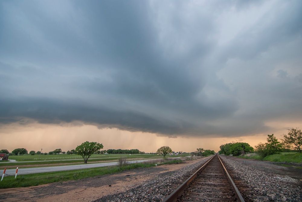
Minnesota and the surrounding area will be the focus for severe weather today with tornadoes, hail and damaging winds. Lower severe wind and hail chances extend southward into the Texas Panhandle.
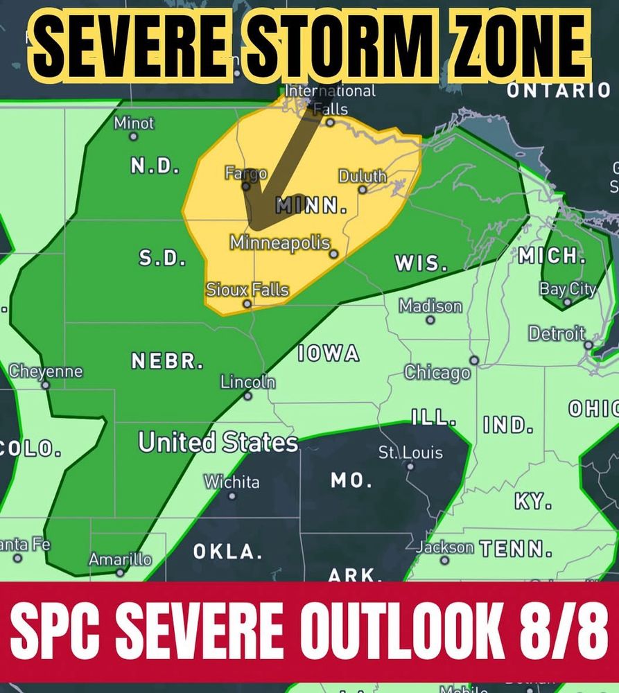
August 8, 2025 at 1:05 PM
Minnesota and the surrounding area will be the focus for severe weather today with tornadoes, hail and damaging winds. Lower severe wind and hail chances extend southward into the Texas Panhandle.
Amazing! NWS will be allowed to fill 450 more positions after deep cuts from DOGE earlier this year. We knew those cuts were a critical mistake to begin with. It’s good to see this for the sake of public safety and to have more great jobs. NWS SAVES LIVES.
August 7, 2025 at 10:14 PM
Amazing! NWS will be allowed to fill 450 more positions after deep cuts from DOGE earlier this year. We knew those cuts were a critical mistake to begin with. It’s good to see this for the sake of public safety and to have more great jobs. NWS SAVES LIVES.
An ABOVE NORMAL Atlantic Hurricane Season is the most likely scenario in the latest outlook from NOAA/NHC. The confidence in this is 50%, with 35% chance of near normal and 15% chance of below normal!
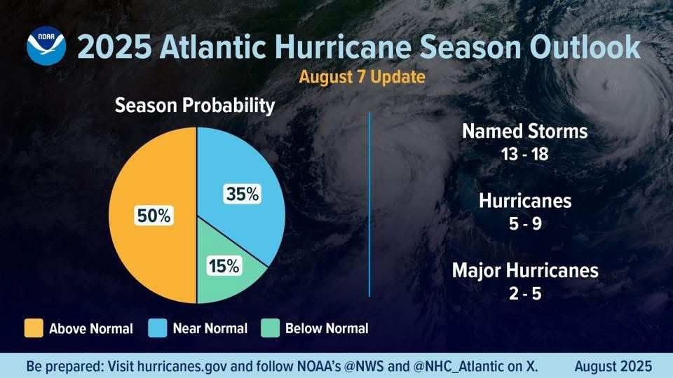
August 7, 2025 at 6:02 PM
An ABOVE NORMAL Atlantic Hurricane Season is the most likely scenario in the latest outlook from NOAA/NHC. The confidence in this is 50%, with 35% chance of near normal and 15% chance of below normal!
North Dakota will be under the gun today with a slight risk of tornadoes and enhanced risk of damaging wind and hail.
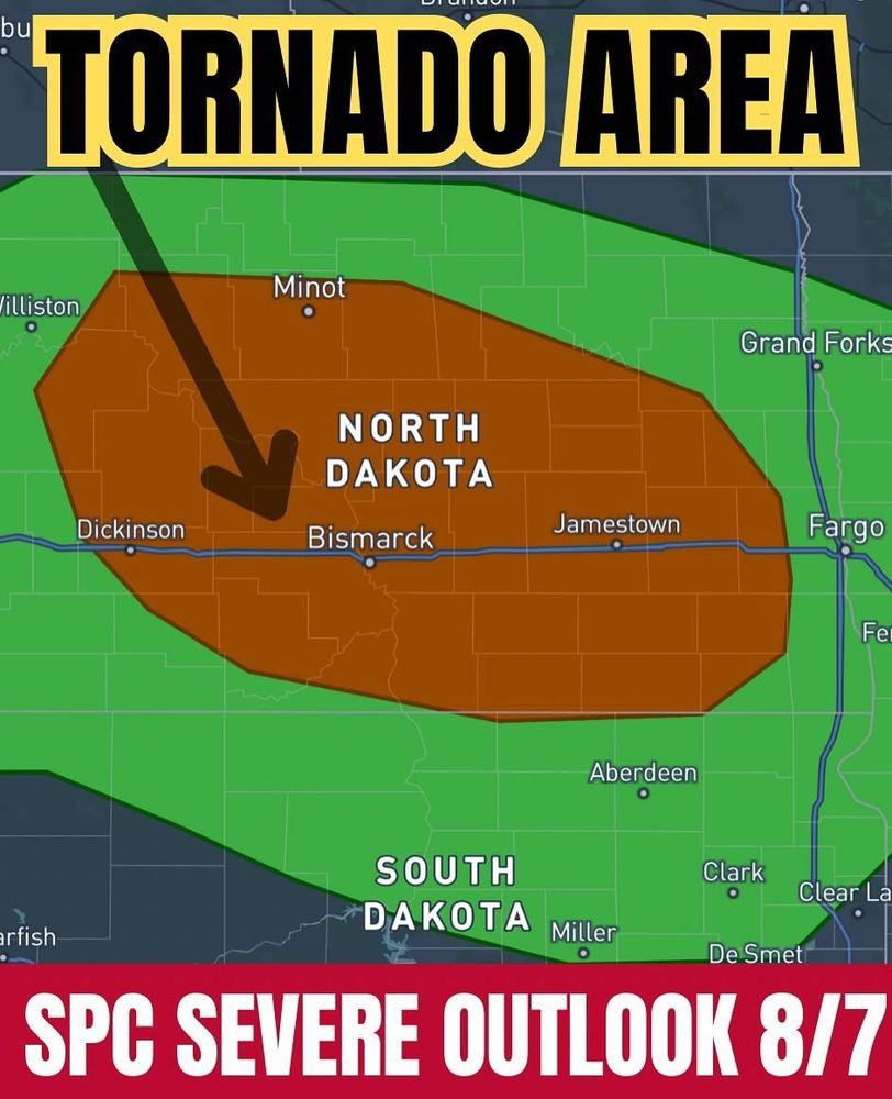
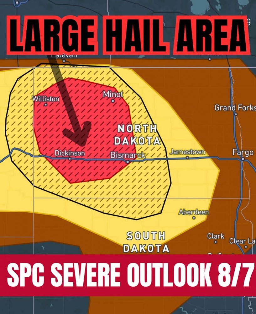
August 7, 2025 at 1:09 PM
North Dakota will be under the gun today with a slight risk of tornadoes and enhanced risk of damaging wind and hail.
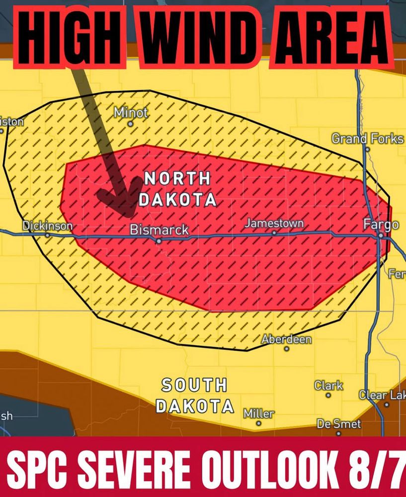
The next two days feature Enhanced Risk areas in North Dakota and Minnesota! Stay weather aware especially in the orange shaded regions. Widespread damaging winds will be the primary concern with a few tornadoes and instances of big hail. August 7-8th.
#severe #storm #weather #northdakota #ndwx
#severe #storm #weather #northdakota #ndwx
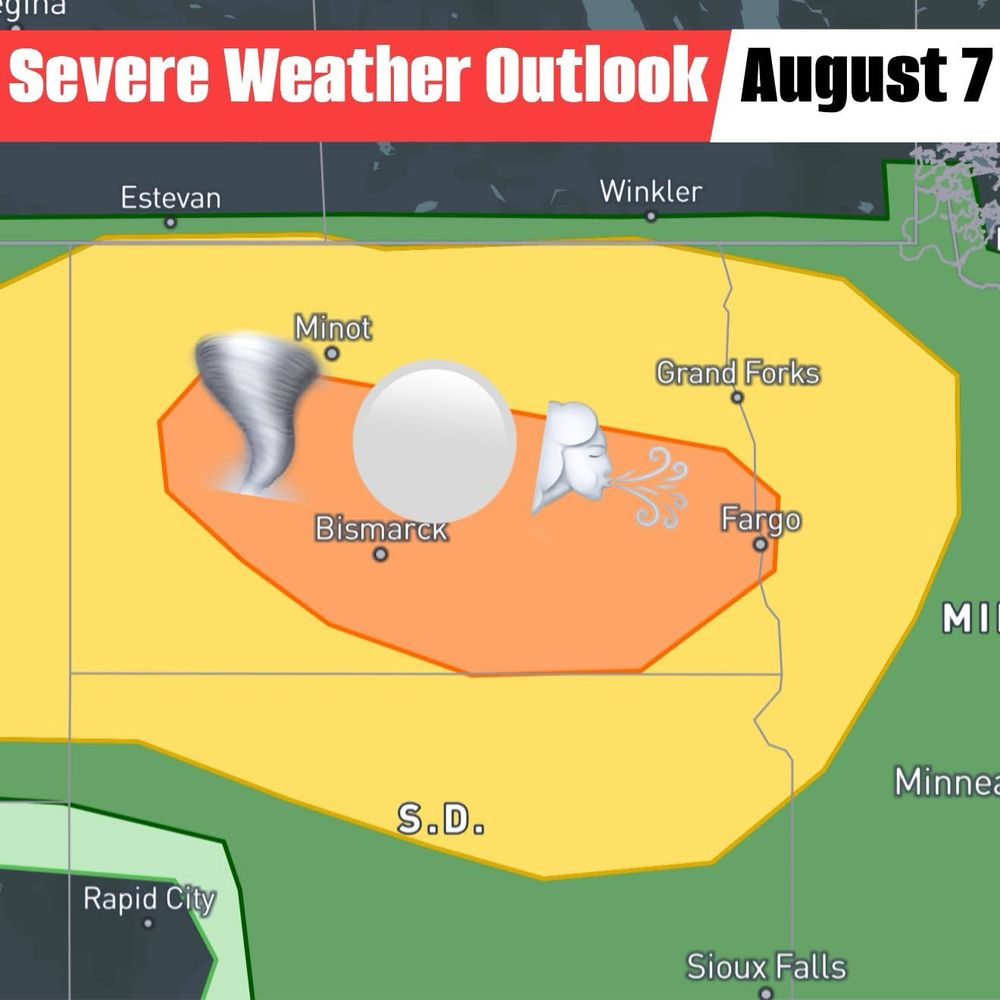
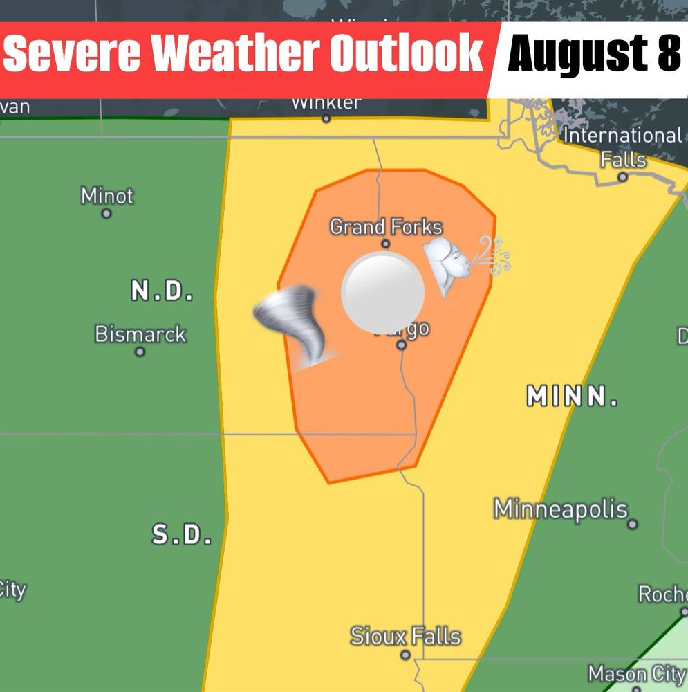
August 6, 2025 at 11:04 PM
The next two days feature Enhanced Risk areas in North Dakota and Minnesota! Stay weather aware especially in the orange shaded regions. Widespread damaging winds will be the primary concern with a few tornadoes and instances of big hail. August 7-8th.
#severe #storm #weather #northdakota #ndwx
#severe #storm #weather #northdakota #ndwx
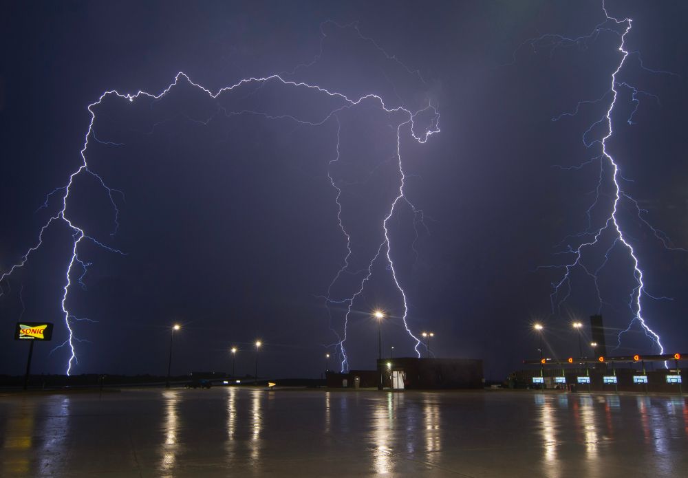
Photography of the Day: Storms that put on a structure and lightning show in North Texas on April 17, 2019.
#txwx #stormchaser #photography #weather
#txwx #stormchaser #photography #weather
August 6, 2025 at 12:14 AM
Photography of the Day: Storms that put on a structure and lightning show in North Texas on April 17, 2019.
#txwx #stormchaser #photography #weather
#txwx #stormchaser #photography #weather
A few tornadoes possible today (Aug 5) in the Dakotas!! May also see large hail and damaging winds across the tornado area. Stay safe, have multiple ways to receive warnings!
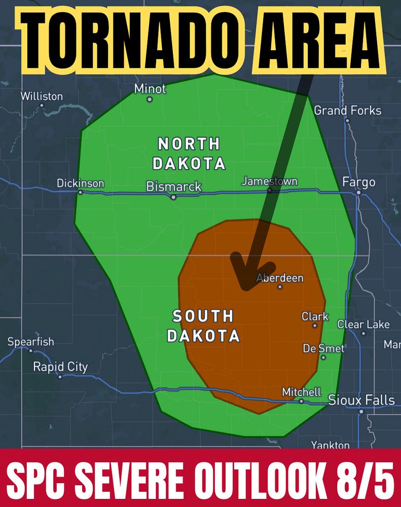
August 5, 2025 at 2:24 PM
A few tornadoes possible today (Aug 5) in the Dakotas!! May also see large hail and damaging winds across the tornado area. Stay safe, have multiple ways to receive warnings!
Photography of the Day: A nice sculpted supercell next to the Kansas City skyline on April 13, 2018.
#storm #stormchasing #weather #kansascity #kc
#storm #stormchasing #weather #kansascity #kc
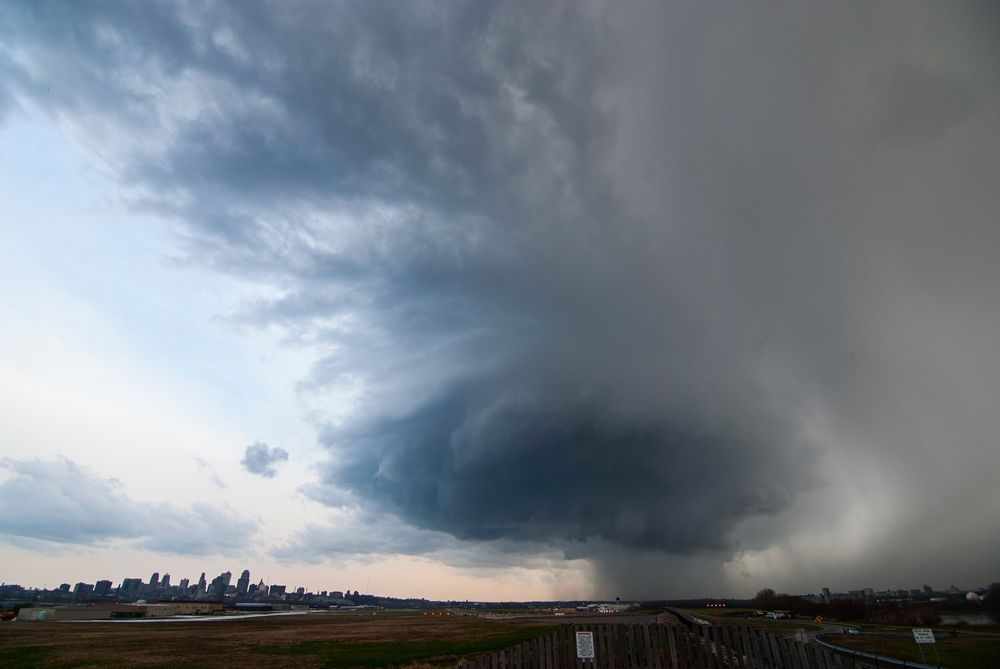
July 27, 2025 at 2:28 PM
Photography of the Day: A nice sculpted supercell next to the Kansas City skyline on April 13, 2018.
#storm #stormchasing #weather #kansascity #kc
#storm #stormchasing #weather #kansascity #kc
Flood footage: Disastrous Flash Flooding Wipes Out RV Park Near Georgetown, Texas
youtu.be/JSl5HXxVP0g
youtu.be/JSl5HXxVP0g
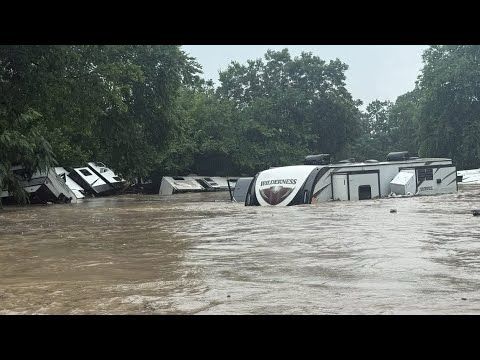
Disastrous Flash Flooding Wipes Out RV Park Near Georgetown, Texas
YouTube video by Texas Storm Chasers
youtu.be
July 5, 2025 at 9:35 PM
Flood footage: Disastrous Flash Flooding Wipes Out RV Park Near Georgetown, Texas
youtu.be/JSl5HXxVP0g
youtu.be/JSl5HXxVP0g
An amazing scene as this supercell tracked through the Texas Panhandle on April 11, 2015!
#supercellsunday #storm #stormchaser #weather
#supercellsunday #storm #stormchaser #weather
April 14, 2025 at 4:15 AM
An amazing scene as this supercell tracked through the Texas Panhandle on April 11, 2015!
#supercellsunday #storm #stormchaser #weather
#supercellsunday #storm #stormchaser #weather
🌪️+🌈 = CRAZY juxtaposition! This #tornado in Lockett, TX lined up so perfectly with a #rainbow! My best weather photos EVER were taken during this moment.
April 23, 2021 tornadoes in Northwest #Texas.
#txwx #storm #stormchasing #stormchaser #sky #amazing #twister #twisters #skydrama
April 23, 2021 tornadoes in Northwest #Texas.
#txwx #storm #stormchasing #stormchaser #sky #amazing #twister #twisters #skydrama
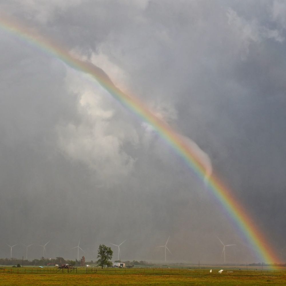
March 21, 2025 at 1:09 PM
This is a supercell storm that was getting ready to drop very large hail and a wedge #tornado near Elk City, Oklahoma on May 16, 2017. #stormchasing
March 10, 2025 at 10:59 PM
This is a supercell storm that was getting ready to drop very large hail and a wedge #tornado near Elk City, Oklahoma on May 16, 2017. #stormchasing
Reposted by Jason Cooley
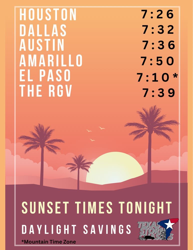
Wow it’s already after 6PM, where did the day go? We still have over an hour before sunset though thanks to Daylight Saving Time. #texas #daylightsavings
March 9, 2025 at 11:24 PM
Wow it’s already after 6PM, where did the day go? We still have over an hour before sunset though thanks to Daylight Saving Time. #texas #daylightsavings
Reposted by Jason Cooley
We have a risk of damaging hailstorms tonight across parts of North Texas. Get woken up to a call from David Reimer if and when you’re in the path of a significant storm with our partners at WeatherCall NexGen. You can sign up here: buff.ly/N5GB1Fx

March 8, 2025 at 1:23 AM
We have a risk of damaging hailstorms tonight across parts of North Texas. Get woken up to a call from David Reimer if and when you’re in the path of a significant storm with our partners at WeatherCall NexGen. You can sign up here: buff.ly/N5GB1Fx
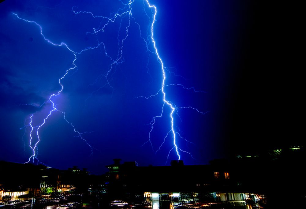
One of my favorite lightning chase days was June 12, 2018 in Buffalo, Oklahoma! #lightning #stormchasing #weather #sky #storm
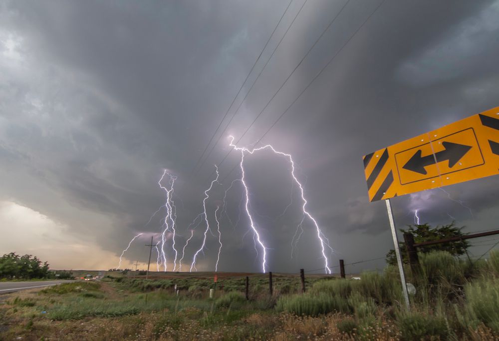
March 1, 2025 at 7:32 PM
One of my favorite lightning chase days was June 12, 2018 in Buffalo, Oklahoma! #lightning #stormchasing #weather #sky #storm
Sometimes even the innocuous storms that would seemingly be boring to chase can put on a great display. “Whale’s Mouth cloud formation in McKinney, TX on 6/7/2021. #stormchasers #weather #sky #storm
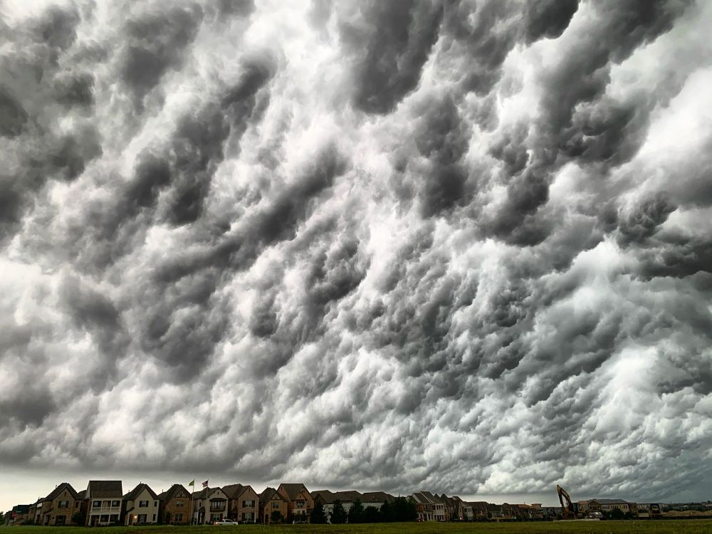
February 23, 2025 at 4:26 PM
Sometimes even the innocuous storms that would seemingly be boring to chase can put on a great display. “Whale’s Mouth cloud formation in McKinney, TX on 6/7/2021. #stormchasers #weather #sky #storm
A beastly #tornado in Coleridge, Nebraska on June 17, 2014! #stormchasers
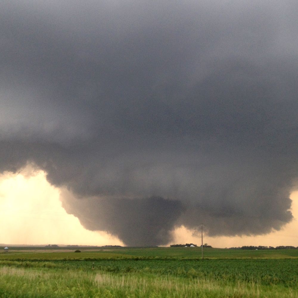
February 21, 2025 at 8:05 PM
A beastly #tornado in Coleridge, Nebraska on June 17, 2014! #stormchasers