


Sid Sperry
@spia-index.bsky.social
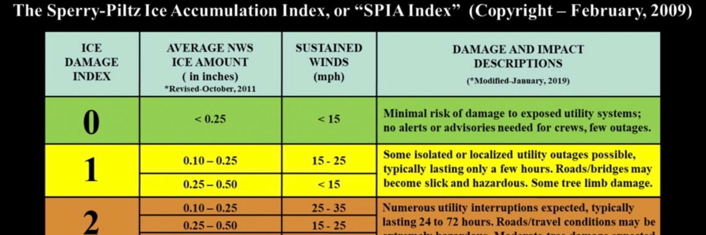
Retired electric utility executive; creator of the “Sperry-Piltz Ice Accumulation Index,” an impact-based, decision support forecast product used by electric & communications utilities across the CONUS. NCA4 (2018) Chapter 23. Website/Subs: SPIDItech.com
Poor Bermuda. Could it be impacted yet again by another Tropical Storm or Hurricane? Ugh.

October 6, 2025 at 1:45 AM
Poor Bermuda. Could it be impacted yet again by another Tropical Storm or Hurricane? Ugh.
Wait… I thought the Oil & Gas Industry was going to “drill, baby, drill” under this Administration, with THOUSANDS OF JOBS BEING CREATED?!?
(Photo & article from Associated Press)
(Photo & article from Associated Press)

September 3, 2025 at 8:13 PM
Wait… I thought the Oil & Gas Industry was going to “drill, baby, drill” under this Administration, with THOUSANDS OF JOBS BEING CREATED?!?
(Photo & article from Associated Press)
(Photo & article from Associated Press)
Newest member of the family. An 11-week old Bernedoodle named “Bernie Mack.” He’s a winner! And is getting along well with our Victorian Bulldog, Gracie Belle!


September 1, 2025 at 2:57 PM
Newest member of the family. An 11-week old Bernedoodle named “Bernie Mack.” He’s a winner! And is getting along well with our Victorian Bulldog, Gracie Belle!
Nothing like sleeping on your back. Gracie Belle - the Queen of “couch sleeping” - and, snoring! LOL!

August 3, 2025 at 1:59 AM
Nothing like sleeping on your back. Gracie Belle - the Queen of “couch sleeping” - and, snoring! LOL!
Here’s a map from the QuakeFeed App of the latest earthquake near our home east of Guthrie, OK. 3.2 magnitude, epicenter 3 miles north-northeast of Sperry Ranch.

July 24, 2025 at 6:49 PM
Here’s a map from the QuakeFeed App of the latest earthquake near our home east of Guthrie, OK. 3.2 magnitude, epicenter 3 miles north-northeast of Sperry Ranch.
Dueling outflow boundaries…

July 8, 2025 at 8:31 PM
Dueling outflow boundaries…
We’re NOT doing “fine” in Oklahoma. And the “Big Beautiful Bill” will only make things worse. Top 10 in Childhood Poverty; Top 10 in Least Educated. Time for change; it doesn’t have to be this way.

July 3, 2025 at 11:33 AM
We’re NOT doing “fine” in Oklahoma. And the “Big Beautiful Bill” will only make things worse. Top 10 in Childhood Poverty; Top 10 in Least Educated. Time for change; it doesn’t have to be this way.
Explaining the “NO CHEWING” rules to Gracie Bell. Doesn’t seem to be working…

May 24, 2025 at 3:27 PM
Explaining the “NO CHEWING” rules to Gracie Bell. Doesn’t seem to be working…
Close to 12” of snow possible in parts of northeast OK over next 24-36 hours. And, 1/4” ice possible across parts southeast OK & west-central AR. Treacherous temps, and driving conditions across much of OK, AR.


February 18, 2025 at 5:54 PM
Close to 12” of snow possible in parts of northeast OK over next 24-36 hours. And, 1/4” ice possible across parts southeast OK & west-central AR. Treacherous temps, and driving conditions across much of OK, AR.
And, so it begins. Second round of prescription drug price reduction negotiations for Medicare & Medicaid recipients is RESCINDED by Trump executive order, Day 1. Here’s the list of prescription drugs that would have been reduced in price in 2025:


January 22, 2025 at 12:39 AM
And, so it begins. Second round of prescription drug price reduction negotiations for Medicare & Medicaid recipients is RESCINDED by Trump executive order, Day 1. Here’s the list of prescription drugs that would have been reduced in price in 2025:
Long-Term Forecast Models per Pivotal Weather (GFS, ECMWF & NBM) show potential freezing rain event from Tuesday thru Friday of next week, Jan. 21 - 24. Still 4 or 5 days out from start of event, so there’s still uncertainty in footprint path and ice amounts-if any! More confidence by Saturday 1/18


January 16, 2025 at 5:01 PM
Long-Term Forecast Models per Pivotal Weather (GFS, ECMWF & NBM) show potential freezing rain event from Tuesday thru Friday of next week, Jan. 21 - 24. Still 4 or 5 days out from start of event, so there’s still uncertainty in footprint path and ice amounts-if any! More confidence by Saturday 1/18
Second round of winter weather to impact parts of TX, OK, AR, LA, TN, MS, AL, GA, SC, NC & VA Wednesday thru Sunday. Ice amounts currently in the 1/2” to 7/10” range; Snow amounts in the 2” to 8”+ range. Heaviest ice is forecast to be in south-central & northeast TX and northern LA, southern AR.


January 7, 2025 at 2:35 PM
Second round of winter weather to impact parts of TX, OK, AR, LA, TN, MS, AL, GA, SC, NC & VA Wednesday thru Sunday. Ice amounts currently in the 1/2” to 7/10” range; Snow amounts in the 2” to 8”+ range. Heaviest ice is forecast to be in south-central & northeast TX and northern LA, southern AR.
A nasty winter storm has already begun in parts of NE and KS this morning, and will be moving east over the next 72-hours. Our SPIA Index Ice Impact Forecast for Electric & Communications Utilities shows Level 4 & 5 impacts possible across parts KS, MO, IL and potentially KY. Prepare now for OUTAGES


January 4, 2025 at 2:34 PM
A nasty winter storm has already begun in parts of NE and KS this morning, and will be moving east over the next 72-hours. Our SPIA Index Ice Impact Forecast for Electric & Communications Utilities shows Level 4 & 5 impacts possible across parts KS, MO, IL and potentially KY. Prepare now for OUTAGES
Our Victorian Bulldog, Gracie Belle, resting easy tonight after an active holiday weekend with family - and a new canine friend, Miss Maple. At 7 months, she’s a solid 55 pounds - still growing!

December 30, 2024 at 3:35 AM
Our Victorian Bulldog, Gracie Belle, resting easy tonight after an active holiday weekend with family - and a new canine friend, Miss Maple. At 7 months, she’s a solid 55 pounds - still growing!
Our first rainfall of more than 1/4” in more than 35 days here at Sperry Ranch overnight. It’s a nice 0.87” in the gauge this morning! A welcome sight on Christmas Eve. Thank you, Lord!

December 24, 2024 at 2:11 PM
Our first rainfall of more than 1/4” in more than 35 days here at Sperry Ranch overnight. It’s a nice 0.87” in the gauge this morning! A welcome sight on Christmas Eve. Thank you, Lord!
SPIA Index Ice Impact Forecast at Level 5 now in the Mt. Washington area of New Hampshire. Max ice accretion in NWS grids forecast: 0.742”.


December 9, 2024 at 1:48 AM
SPIA Index Ice Impact Forecast at Level 5 now in the Mt. Washington area of New Hampshire. Max ice accretion in NWS grids forecast: 0.742”.
Levels 1 through 3 ice impacts possible in parts of northern New Hampshire over next 12-36 hours. Max ice in NWS grids: 0.33”.


December 8, 2024 at 2:23 PM
Levels 1 through 3 ice impacts possible in parts of northern New Hampshire over next 12-36 hours. Max ice in NWS grids: 0.33”.
Light ice accumulation across parts of WA, ID, MT, ND, SD, MN, WI, NY, VT & NH. Max ice in NWS forecast grids: 0.194”. SPIA Index Ice Impact Forecast: Levels 1 & 2.


December 8, 2024 at 4:01 AM
Light ice accumulation across parts of WA, ID, MT, ND, SD, MN, WI, NY, VT & NH. Max ice in NWS forecast grids: 0.194”. SPIA Index Ice Impact Forecast: Levels 1 & 2.
Some light icing this AM through tomorrow in parts of the Northeast Region. Max ice in NWS grids currently 0.104” higher elevation areas of WV. Current SPIA Index Ice Impact Forecast for Electric & Communications Utilities: Levels 1 & 2.


November 28, 2024 at 4:28 PM
Some light icing this AM through tomorrow in parts of the Northeast Region. Max ice in NWS grids currently 0.104” higher elevation areas of WV. Current SPIA Index Ice Impact Forecast for Electric & Communications Utilities: Levels 1 & 2.
Latest Ice Accretion Forecasts for Oregon and New Hampshire (most in high elevation areas). Max Ice in NWS Grids for OR: 0.175”; SPIA Index Ice Impact Forecast: Levels 1 & 2. Max Ice in NWS Grids for NH: 0.36” (Mt. Washington area); SPIA Index Ice Impact Forecast: Levels 1 thru 4.


November 21, 2024 at 11:59 PM
Latest Ice Accretion Forecasts for Oregon and New Hampshire (most in high elevation areas). Max Ice in NWS Grids for OR: 0.175”; SPIA Index Ice Impact Forecast: Levels 1 & 2. Max Ice in NWS Grids for NH: 0.36” (Mt. Washington area); SPIA Index Ice Impact Forecast: Levels 1 thru 4.
Up to 0.60” ice accretion in the forecast for parts northern NH over next 48-hrs (Mt. Washington area). Current SPIA Index Ice Impact Forecast is at Levels 1 thru 4.


November 21, 2024 at 2:12 PM
Up to 0.60” ice accretion in the forecast for parts northern NH over next 48-hrs (Mt. Washington area). Current SPIA Index Ice Impact Forecast is at Levels 1 thru 4.
Our Victorian Bulldog, Gracie Belle, has the perfect solution for a rainy Monday morning

November 18, 2024 at 3:01 PM
Our Victorian Bulldog, Gracie Belle, has the perfect solution for a rainy Monday morning
Storm is almost past us now. Heavy rain, high winds. But, no hail, not much thunder or lightning.

November 18, 2024 at 1:16 PM
Storm is almost past us now. Heavy rain, high winds. But, no hail, not much thunder or lightning.
Two of my favorite things: studies of ice accretion on electric distribution and transmission power lines… and… our Victorian Bulldog, Miss Gracie Belle!


November 18, 2024 at 4:19 AM
Two of my favorite things: studies of ice accretion on electric distribution and transmission power lines… and… our Victorian Bulldog, Miss Gracie Belle!

