


TROPICS: The Atlantic basin remains quiet and tropical storm formation is not expected for at least the next seven days.

November 4, 2025 at 11:38 AM
TROPICS: The Atlantic basin remains quiet and tropical storm formation is not expected for at least the next seven days.
Quite the pattern change ahead. Hotter, drier days ahead for the eastern and southeastern U.S. by Friday and the weekend.
The persistent upper trough near the Mississippi River (which has kept the weather unsettled) will be replaced by a strong upper ridge in a few days.
The persistent upper trough near the Mississippi River (which has kept the weather unsettled) will be replaced by a strong upper ridge in a few days.


June 17, 2025 at 9:19 PM
Quite the pattern change ahead. Hotter, drier days ahead for the eastern and southeastern U.S. by Friday and the weekend.
The persistent upper trough near the Mississippi River (which has kept the weather unsettled) will be replaced by a strong upper ridge in a few days.
The persistent upper trough near the Mississippi River (which has kept the weather unsettled) will be replaced by a strong upper ridge in a few days.
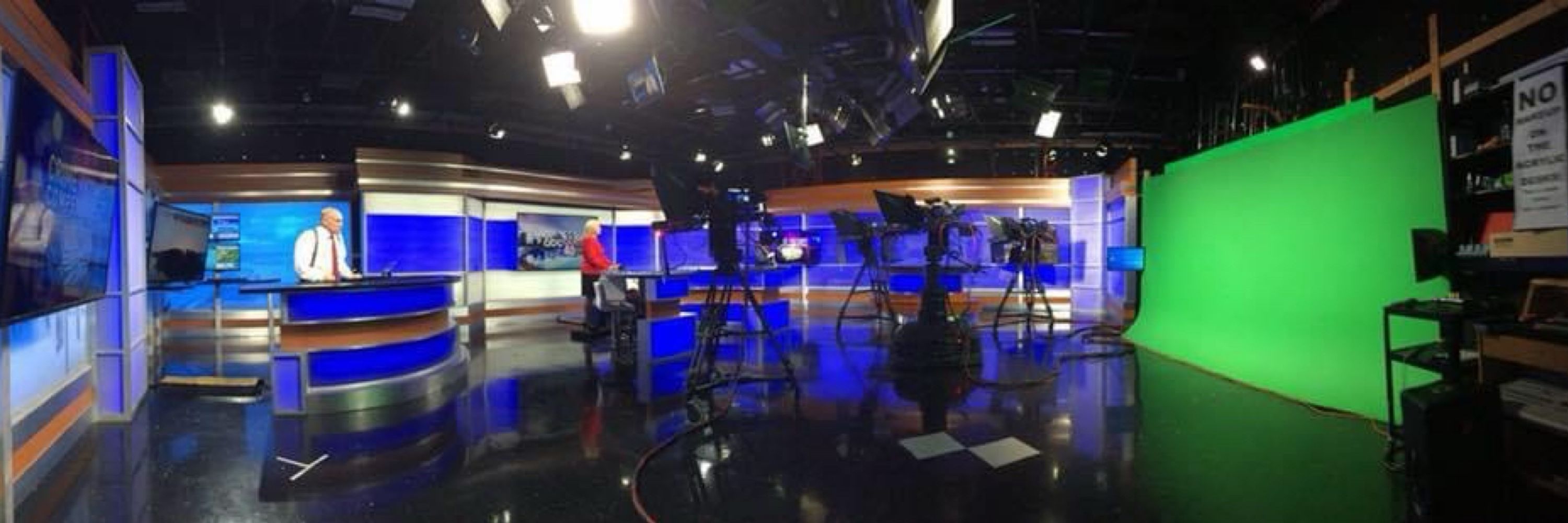
Good morning to everyone except this guy…

April 21, 2025 at 12:12 PM
Good morning to everyone except this guy…
There are over 14,000 power outages across Alabama this morning; most of them in the Shoals area...

April 6, 2025 at 12:31 PM
There are over 14,000 power outages across Alabama this morning; most of them in the Shoals area...

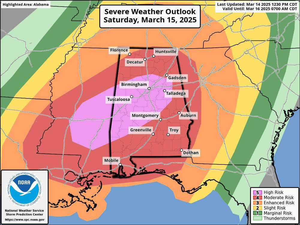
A high risk (level 5/5) has been defined for parts of AL and MS for “round two” tomorrow afternoon/night. A new video briefing will be up shortly.
March 14, 2025 at 5:37 PM
A high risk (level 5/5) has been defined for parts of AL and MS for “round two” tomorrow afternoon/night. A new video briefing will be up shortly.
This is going to be a great event at Ohio State… plan on attending if you can!

February 26, 2025 at 4:10 AM
This is going to be a great event at Ohio State… plan on attending if you can!
A tornado watch is an effect for much of Alabama until 4a CT. The main threat will be from strong, potentially damaging winds, but a few isolated tornadoes are possible.

February 16, 2025 at 3:26 AM
A tornado watch is an effect for much of Alabama until 4a CT. The main threat will be from strong, potentially damaging winds, but a few isolated tornadoes are possible.
Active days are ahead… A heavy rain threat tomorrow and Wednesday… Followed by severe weather potential and more heavy rain Saturday and Saturday night.


February 10, 2025 at 1:34 PM
Active days are ahead… A heavy rain threat tomorrow and Wednesday… Followed by severe weather potential and more heavy rain Saturday and Saturday night.
Impressive view of the dense fog over Birmingham this morning… Photo from Scott Thorne

January 28, 2025 at 1:07 PM
Impressive view of the dense fog over Birmingham this morning… Photo from Scott Thorne
MOBILE: The current NWS forecast for Mobile tomorrow is for 2-4 inches of snow.
The last snowfall to exceed 2 inches in Mobile was in March 1993 (the great "Blizzard of 93).
The record snowfall recorded for Mobile seems to be generally regarded as 6 inches in February of 1895.
The last snowfall to exceed 2 inches in Mobile was in March 1993 (the great "Blizzard of 93).
The record snowfall recorded for Mobile seems to be generally regarded as 6 inches in February of 1895.

January 20, 2025 at 12:57 PM
MOBILE: The current NWS forecast for Mobile tomorrow is for 2-4 inches of snow.
The last snowfall to exceed 2 inches in Mobile was in March 1993 (the great "Blizzard of 93).
The record snowfall recorded for Mobile seems to be generally regarded as 6 inches in February of 1895.
The last snowfall to exceed 2 inches in Mobile was in March 1993 (the great "Blizzard of 93).
The record snowfall recorded for Mobile seems to be generally regarded as 6 inches in February of 1895.
BRRR: Here are forecast temperatures and wind chill indices at 7a CT tomorrow.


January 20, 2025 at 12:11 AM
BRRR: Here are forecast temperatures and wind chill indices at 7a CT tomorrow.
Gatlinburg… video from Summer Guyton
January 19, 2025 at 7:11 PM
Gatlinburg… video from Summer Guyton
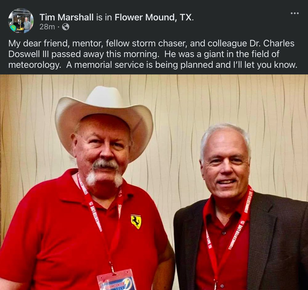
Very sad news. I learned more about severe local convective storms from Chuck Doswell than anyone else. He was a friend and mentor.
January 18, 2025 at 6:40 PM
Very sad news. I learned more about severe local convective storms from Chuck Doswell than anyone else. He was a friend and mentor.
Starship 7 debris over Turks and Caicos earlier this evening… video from Stacey Evans
January 17, 2025 at 1:42 AM
Starship 7 debris over Turks and Caicos earlier this evening… video from Stacey Evans
Here is the new probabilistic output from the European global model ensemble set (18Z) through next Wednesday. The chance of one inch or snow or greater has jumped up to over 50 percent over the southern half of Alabama.
Signals for a Deep South winter storm continue to show up next Tuesday…
Signals for a Deep South winter storm continue to show up next Tuesday…

January 17, 2025 at 12:08 AM
Here is the new probabilistic output from the European global model ensemble set (18Z) through next Wednesday. The chance of one inch or snow or greater has jumped up to over 50 percent over the southern half of Alabama.
Signals for a Deep South winter storm continue to show up next Tuesday…
Signals for a Deep South winter storm continue to show up next Tuesday…
The probability of a winter storm across the southern U.S. next week continues to increase based on new model data… I will have a new video briefing and discussion posted here by 3 PM. 

January 15, 2025 at 7:11 PM
The probability of a winter storm across the southern U.S. next week continues to increase based on new model data… I will have a new video briefing and discussion posted here by 3 PM. 
From Ron Burkett “Here’s a shot taken seconds before Mars slipped behind the moon. (Mars can be seen at about the 5:30 position)”

January 14, 2025 at 3:03 AM
From Ron Burkett “Here’s a shot taken seconds before Mars slipped behind the moon. (Mars can be seen at about the 5:30 position)”
DeSoto Falls yesterday… video from Brad Lackey
January 13, 2025 at 2:01 AM
DeSoto Falls yesterday… video from Brad Lackey
LOOKING AHEAD: Using pattern recognition, it sure looks like another shot of very cold Arctic air will invade the Deep South later this month.
How cold? Any snow or ice? Way too early to know.
How cold? Any snow or ice? Way too early to know.


January 11, 2025 at 9:15 PM
LOOKING AHEAD: Using pattern recognition, it sure looks like another shot of very cold Arctic air will invade the Deep South later this month.
How cold? Any snow or ice? Way too early to know.
How cold? Any snow or ice? Way too early to know.
Here is the progression of precipitation across Alabama tomorrow (HRRR)… For the northern half of the state it starts as a very messy wintry mix followed by a change over to cold rain.
January 9, 2025 at 2:21 PM
Here is the progression of precipitation across Alabama tomorrow (HRRR)… For the northern half of the state it starts as a very messy wintry mix followed by a change over to cold rain.
De-icing at BHM Airport this morning. Video from Kevin Henderson.
January 9, 2025 at 1:57 PM
De-icing at BHM Airport this morning. Video from Kevin Henderson.
The Palisades Fire and Eaton Fire continue their rapid growth near Los Angeles as both have scorched over 10,000 acres. Via @cira_csu
January 9, 2025 at 12:09 AM
The Palisades Fire and Eaton Fire continue their rapid growth near Los Angeles as both have scorched over 10,000 acres. Via @cira_csu
Good morning to everyone except this guy…

January 8, 2025 at 12:22 PM
Good morning to everyone except this guy…
New 00Z NBM depiction of snow potential Friday.
2-4” for North Alabama; locally higher amounts. Around 1-2” for the I-20 corridor.
It all begins early Friday morning in Alabama.
A winter storm watch will be issued early tomorrow.
2-4” for North Alabama; locally higher amounts. Around 1-2” for the I-20 corridor.
It all begins early Friday morning in Alabama.
A winter storm watch will be issued early tomorrow.

January 8, 2025 at 1:49 AM
New 00Z NBM depiction of snow potential Friday.
2-4” for North Alabama; locally higher amounts. Around 1-2” for the I-20 corridor.
It all begins early Friday morning in Alabama.
A winter storm watch will be issued early tomorrow.
2-4” for North Alabama; locally higher amounts. Around 1-2” for the I-20 corridor.
It all begins early Friday morning in Alabama.
A winter storm watch will be issued early tomorrow.