


Steve LaPointe WRGB-CBS6
@slapointewx.bsky.social
Chief Meteorologist at WRGB-CBS6 - Albany-Schenectady-Troy, NY
It’s a nice start to May in the Capital Region with a great evening sky and mild, pleasant breeze. This of course precedes what will be days of gloom in Our very near future. Womp womp

May 1, 2025 at 11:41 PM
It’s a nice start to May in the Capital Region with a great evening sky and mild, pleasant breeze. This of course precedes what will be days of gloom in Our very near future. Womp womp
The yard is really lighting up with spring color, flowers opening up fast with the warm weather


April 25, 2025 at 10:27 PM
The yard is really lighting up with spring color, flowers opening up fast with the warm weather
Nice sky over Schenectady right now

April 21, 2025 at 11:50 PM
Nice sky over Schenectady right now
shelf cloud going over the station, just in advance of a gusty downpour

April 19, 2025 at 11:24 PM
shelf cloud going over the station, just in advance of a gusty downpour
It’s faint but there’s a little solar halo action going on right now.

April 18, 2025 at 5:48 PM
It’s faint but there’s a little solar halo action going on right now.
Spring is lighting up in upstate NY, forsythia now coming into bloom - Clifton Park, April 17


April 17, 2025 at 4:22 PM
Spring is lighting up in upstate NY, forsythia now coming into bloom - Clifton Park, April 17
A little spring on this windy wintry feeling spring day. I tossed these bulbs in the woods years ago because they didn’t bloom any more in the yard. They naturalized and every year now I get this spring bonus in the woods

April 8, 2025 at 3:48 PM
A little spring on this windy wintry feeling spring day. I tossed these bulbs in the woods years ago because they didn’t bloom any more in the yard. They naturalized and every year now I get this spring bonus in the woods
Very cool evening sky with sprinkles in progress here at CBS6

April 3, 2025 at 11:36 PM
Very cool evening sky with sprinkles in progress here at CBS6
Nice 22 degree solar halo over Clifton park right now

March 28, 2025 at 3:15 PM
Nice 22 degree solar halo over Clifton park right now
Warm again today with temps. running a good 20° higher than typical. Background climate warming making the level of today's warmth 1.5 times more likely according to Climate Central's Climate Shift Index. Same air mass and pattern 50-60 years ago would still have been warm, just not this warm.


March 20, 2025 at 10:05 PM
Warm again today with temps. running a good 20° higher than typical. Background climate warming making the level of today's warmth 1.5 times more likely according to Climate Central's Climate Shift Index. Same air mass and pattern 50-60 years ago would still have been warm, just not this warm.
Climate Central's Climate Shift Index showing a strong connection to back ground climate warming in how high today's temps. climbed in the upper Mississippi valley with the level of warmth made 3-5 times more likely than if climate warming had not occurred.


March 15, 2025 at 12:34 AM
Climate Central's Climate Shift Index showing a strong connection to back ground climate warming in how high today's temps. climbed in the upper Mississippi valley with the level of warmth made 3-5 times more likely than if climate warming had not occurred.
St. Patrick's Day parade weather is looking good in Albany this Saturday...breezy, but that's Albany, mild and dry...similar conditions to how it was last year.

March 13, 2025 at 8:00 PM
St. Patrick's Day parade weather is looking good in Albany this Saturday...breezy, but that's Albany, mild and dry...similar conditions to how it was last year.
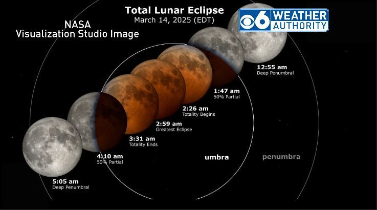
Total lunar eclipse on schedule for very early Friday morning...viewing conditions look pretty good for us in the Capital Region. Some patchy clouds around but clear periods too. Expect temperatures in the 30s with light wind conditions.

March 13, 2025 at 7:35 PM
Total lunar eclipse on schedule for very early Friday morning...viewing conditions look pretty good for us in the Capital Region. Some patchy clouds around but clear periods too. Expect temperatures in the 30s with light wind conditions.
Sunrise from Hallandale Beach, FL this morning. Rare on my shift to see a sunrise, but vacation does offer the rare opportunity


February 27, 2025 at 10:49 PM
Sunrise from Hallandale Beach, FL this morning. Rare on my shift to see a sunrise, but vacation does offer the rare opportunity
Saw the SS United States yesterday as she was passing Ft. Lauderdale on her way to the Gulf of Mexico where she’ll be sunk to make an artificial reef. Pretty awesome to see


February 27, 2025 at 2:20 PM
Saw the SS United States yesterday as she was passing Ft. Lauderdale on her way to the Gulf of Mexico where she’ll be sunk to make an artificial reef. Pretty awesome to see
High wind watch up from NWS for Sunday night and Monday as the concern for particularly strong and damaging wind is increasing. Peak gust potential 60-65 mph. With snow and ice likely on the trees from Sunday, the power outage potential in this type of wind scenario would be high.

February 15, 2025 at 4:44 PM
High wind watch up from NWS for Sunday night and Monday as the concern for particularly strong and damaging wind is increasing. Peak gust potential 60-65 mph. With snow and ice likely on the trees from Sunday, the power outage potential in this type of wind scenario would be high.
Our weekend storm will bring front end snow, then significant sleet and freezing rain on Sunday. Snow/sleet forecast is through noon Sunday and is sensitive to changeover times. Icing potential is significant on Sunday, power outages possible along with hazardous travel conditions.


February 15, 2025 at 2:23 AM
Our weekend storm will bring front end snow, then significant sleet and freezing rain on Sunday. Snow/sleet forecast is through noon Sunday and is sensitive to changeover times. Icing potential is significant on Sunday, power outages possible along with hazardous travel conditions.
After the wind tonight and tomorrow it's onto the next storm this weekend...long duration. Phase I will be a light intensity snow Sat PM/Night, 3-6" by 7am Sun. Phase II is more complex on Sunday with sleet and frz. rain. An ice storm for parts of the area is possible. More snow for the north.


February 14, 2025 at 1:59 AM
After the wind tonight and tomorrow it's onto the next storm this weekend...long duration. Phase I will be a light intensity snow Sat PM/Night, 3-6" by 7am Sun. Phase II is more complex on Sunday with sleet and frz. rain. An ice storm for parts of the area is possible. More snow for the north.
New wind advisory for parts of the area from 5pm today to 4am Friday. Strong west to northwest winds will be kicking in after a cold front goes by with gusts from 40-50 mph likely at times in the advisory area.

February 13, 2025 at 4:00 PM
New wind advisory for parts of the area from 5pm today to 4am Friday. Strong west to northwest winds will be kicking in after a cold front goes by with gusts from 40-50 mph likely at times in the advisory area.
Minor system tonight into Thursday with some snow, sleet, frz. rain and rain...light and patchy in nature, kicking in as patchy light snow after 7-8pm this evening. Icy surfaces and slick travel the main concern into Thur. AM. Strong gusty ESE wind to impact western New England and the Taconics


February 12, 2025 at 9:18 PM
Minor system tonight into Thursday with some snow, sleet, frz. rain and rain...light and patchy in nature, kicking in as patchy light snow after 7-8pm this evening. Icy surfaces and slick travel the main concern into Thur. AM. Strong gusty ESE wind to impact western New England and the Taconics
Faint lunar halo over the Capital Region around 11:40pm

February 12, 2025 at 4:39 AM
Faint lunar halo over the Capital Region around 11:40pm
This next storm Wed. eve. into Thu. will be more of a nuisance than anything else, but a combo of light snow, sleet, and frz. rain will make for slick surfaces and hazardous travel conditions until the temps come up. It will sputter Wed. eve. with precip. becoming more widespread later at night.


February 11, 2025 at 9:36 PM
This next storm Wed. eve. into Thu. will be more of a nuisance than anything else, but a combo of light snow, sleet, and frz. rain will make for slick surfaces and hazardous travel conditions until the temps come up. It will sputter Wed. eve. with precip. becoming more widespread later at night.
Radar view versus the camera view...how the lake effect snow shower over Schenectady looks at around 5:30pm


February 10, 2025 at 10:35 PM
Radar view versus the camera view...how the lake effect snow shower over Schenectady looks at around 5:30pm
Lots to watch this week with a storm missing us to the south for a change Tuesday night. But the one after that gets us Wednesday night into Thu. AM with a quick shot of snow, then some ice for slick roads. There will be another over the weekend as well as the storm train continues.


February 10, 2025 at 9:37 PM
Lots to watch this week with a storm missing us to the south for a change Tuesday night. But the one after that gets us Wednesday night into Thu. AM with a quick shot of snow, then some ice for slick roads. There will be another over the weekend as well as the storm train continues.
Relative routine, moderate snowfall for all coming in Saturday evening and departing Sunday morning. I'm looking at a widespread and general 5-9" of not too wet or too dry snow. Heaviest to fall between 10pm Sat. and 8am Sun. which is when roads will be impacted the most.


February 7, 2025 at 9:03 PM
Relative routine, moderate snowfall for all coming in Saturday evening and departing Sunday morning. I'm looking at a widespread and general 5-9" of not too wet or too dry snow. Heaviest to fall between 10pm Sat. and 8am Sun. which is when roads will be impacted the most.