


Josh
@severeweatherus.bsky.social
This account tracks severe weather and natural disasters in the U.S & Canada.
This includes tornadoes, hurricanes, earthquakes etc.
This includes tornadoes, hurricanes, earthquakes etc.
WOW! BEAUTIFUL near Millinocket, Maine last night!!
(Image: NEOC Starcam)
(Image: NEOC Starcam)

September 15, 2025 at 12:02 PM
WOW! BEAUTIFUL near Millinocket, Maine last night!!
(Image: NEOC Starcam)
(Image: NEOC Starcam)
It's been 24 years since the September 11, 2001 terrorist attacks in the United States that killed 2,977 innocent people.
Here is a photo of the sun rising over the New World Trade Center in New York City this morning.
We will NEVER forget.
(Image: EarthCam)
Here is a photo of the sun rising over the New World Trade Center in New York City this morning.
We will NEVER forget.
(Image: EarthCam)

September 11, 2025 at 12:41 PM
It's been 24 years since the September 11, 2001 terrorist attacks in the United States that killed 2,977 innocent people.
Here is a photo of the sun rising over the New World Trade Center in New York City this morning.
We will NEVER forget.
(Image: EarthCam)
Here is a photo of the sun rising over the New World Trade Center in New York City this morning.
We will NEVER forget.
(Image: EarthCam)
Wow!
Big severe thunderstorm with potential for damaging -- straightline winds moving into New York City! (Via webcam)
Big severe thunderstorm with potential for damaging -- straightline winds moving into New York City! (Via webcam)

September 6, 2025 at 7:08 PM
Wow!
Big severe thunderstorm with potential for damaging -- straightline winds moving into New York City! (Via webcam)
Big severe thunderstorm with potential for damaging -- straightline winds moving into New York City! (Via webcam)
Snowy scenes on Pikes Peak, Colorado this morning!
Winter is slowly getting closer...
Winter is slowly getting closer...

September 6, 2025 at 4:12 AM
Snowy scenes on Pikes Peak, Colorado this morning!
Winter is slowly getting closer...
Winter is slowly getting closer...
Wow! The Northern lights are visible near Isle Royale in the Upper Peninsula of Michigan. (Photo via the Isle Royale National Park).

September 2, 2025 at 3:44 AM
Wow! The Northern lights are visible near Isle Royale in the Upper Peninsula of Michigan. (Photo via the Isle Royale National Park).
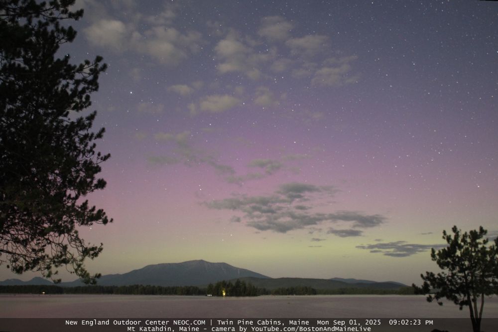
WOW!! Northern light show happening at the Twin Pine Cabins in Millinocket, Maine right now! (Photo via NEOC Starcam).

September 2, 2025 at 2:11 AM
WOW!! Northern light show happening at the Twin Pine Cabins in Millinocket, Maine right now! (Photo via NEOC Starcam).
The Northern Lights are now visible near Twin Pine Cabins, Maine!! (Via NEOC Starcam).
September 2, 2025 at 1:10 AM
The Northern Lights are now visible near Twin Pine Cabins, Maine!! (Via NEOC Starcam).
Maine has a glow starting to show! Here we go! As it continues to get dark, the northern lights will likely become even more visible and beautiful.
Here we go!!
Here we go!!

September 2, 2025 at 12:39 AM
Maine has a glow starting to show! Here we go! As it continues to get dark, the northern lights will likely become even more visible and beautiful.
Here we go!!
Here we go!!
Beautiful Crescent Moon tonight! Photo taken by me.

August 29, 2025 at 4:09 AM
Beautiful Crescent Moon tonight! Photo taken by me.
Wow! Check out this video from a webcam in Emerald Isle, North Carolina as waves are beginning to touch the top of a pier at high tide as Hurricane Erin will be making its closest approach to the Outer Banks of North Carolina. STAY out of the water!
August 20, 2025 at 11:45 PM
Wow! Check out this video from a webcam in Emerald Isle, North Carolina as waves are beginning to touch the top of a pier at high tide as Hurricane Erin will be making its closest approach to the Outer Banks of North Carolina. STAY out of the water!
Hurricane Erin looks crazy on satellite this afternoon! 😳
The time to prepare in the Outer Banks is coming to an end. Conditions are set to deteriorate this evening. This is a massive hurricane.
Hurricane hunters have observed 100+ MPH winds 100 miles from the center of the Erin which is insane.
The time to prepare in the Outer Banks is coming to an end. Conditions are set to deteriorate this evening. This is a massive hurricane.
Hurricane hunters have observed 100+ MPH winds 100 miles from the center of the Erin which is insane.

August 20, 2025 at 7:12 PM
Hurricane Erin looks crazy on satellite this afternoon! 😳
The time to prepare in the Outer Banks is coming to an end. Conditions are set to deteriorate this evening. This is a massive hurricane.
Hurricane hunters have observed 100+ MPH winds 100 miles from the center of the Erin which is insane.
The time to prepare in the Outer Banks is coming to an end. Conditions are set to deteriorate this evening. This is a massive hurricane.
Hurricane hunters have observed 100+ MPH winds 100 miles from the center of the Erin which is insane.
We are still about 2 hours away from this evening's high tide and water is already beginning to impact some areas along the Outer Banks. Here is the view along NC-12 in Buxton, North Carolina (courtesy NCDOT_NC12 ). Storm surge threat should increase later this evening along the Outer Banks.

August 19, 2025 at 7:17 PM
We are still about 2 hours away from this evening's high tide and water is already beginning to impact some areas along the Outer Banks. Here is the view along NC-12 in Buxton, North Carolina (courtesy NCDOT_NC12 ). Storm surge threat should increase later this evening along the Outer Banks.
Lightning flashes continue around the cloud covered eye of Hurricane Erin this evening as it passes near the Bahamas.
Video via NOAA/CIRA_CSU.
Video via NOAA/CIRA_CSU.
August 19, 2025 at 4:15 AM
Lightning flashes continue around the cloud covered eye of Hurricane Erin this evening as it passes near the Bahamas.
Video via NOAA/CIRA_CSU.
Video via NOAA/CIRA_CSU.
An incredible hi-res IR view of Hurricane Erin's impressive eye when it peaked at Category 5 as seen yesterday by GOES-East.
Still in awe. Absolutely insane. Still can't believe how fast Erin intensified.
Still in awe. Absolutely insane. Still can't believe how fast Erin intensified.
August 17, 2025 at 8:53 PM
An incredible hi-res IR view of Hurricane Erin's impressive eye when it peaked at Category 5 as seen yesterday by GOES-East.
Still in awe. Absolutely insane. Still can't believe how fast Erin intensified.
Still in awe. Absolutely insane. Still can't believe how fast Erin intensified.
View of Major Hurricane Erin tonight (8-16). Lots of lightning with this intense hurricane -- which is relatively rare for lightning to occur during hurricanes.
Video: NOAA/CIRA_CSU.
Video: NOAA/CIRA_CSU.
August 17, 2025 at 2:25 AM
View of Major Hurricane Erin tonight (8-16). Lots of lightning with this intense hurricane -- which is relatively rare for lightning to occur during hurricanes.
Video: NOAA/CIRA_CSU.
Video: NOAA/CIRA_CSU.
Category 5 Hurricane Erin looks like it has a skull now! Wow.

August 16, 2025 at 11:04 PM
Category 5 Hurricane Erin looks like it has a skull now! Wow.
The eye of Hurricane Erin is so tiny it appears cloud-filled. I wouldn’t be shocked if there’s winds of 175 mph or higher in Erin.
It's unbelievable how long this tight eyewall has stayed intact. Recon will be on their way to investigate this hurricane.
Erin is one for the history books.
It's unbelievable how long this tight eyewall has stayed intact. Recon will be on their way to investigate this hurricane.
Erin is one for the history books.

August 16, 2025 at 9:13 PM
The eye of Hurricane Erin is so tiny it appears cloud-filled. I wouldn’t be shocked if there’s winds of 175 mph or higher in Erin.
It's unbelievable how long this tight eyewall has stayed intact. Recon will be on their way to investigate this hurricane.
Erin is one for the history books.
It's unbelievable how long this tight eyewall has stayed intact. Recon will be on their way to investigate this hurricane.
Erin is one for the history books.
Put it in the textbook. Category 5 Hurricane Erin is likely intensifying even more northeast of Puerto Rico.
Life threatening flash flooding and even brief tornadoes are possible near the U.S Virgin Islands.
That eye is very wicked!
Life threatening flash flooding and even brief tornadoes are possible near the U.S Virgin Islands.
That eye is very wicked!

August 16, 2025 at 8:19 PM
Put it in the textbook. Category 5 Hurricane Erin is likely intensifying even more northeast of Puerto Rico.
Life threatening flash flooding and even brief tornadoes are possible near the U.S Virgin Islands.
That eye is very wicked!
Life threatening flash flooding and even brief tornadoes are possible near the U.S Virgin Islands.
That eye is very wicked!
Thank you everyone for the kind words and support!
I am beyond grateful for you all. Nearly at 700 followers on BlueSky.
I may not be perfect, but I try my best to cover severe weather/disasters across U.S and Canada.
Thank you for letting me do what I do! I am beyond grateful.
I am beyond grateful for you all. Nearly at 700 followers on BlueSky.
I may not be perfect, but I try my best to cover severe weather/disasters across U.S and Canada.
Thank you for letting me do what I do! I am beyond grateful.

August 13, 2025 at 8:09 PM
Thank you everyone for the kind words and support!
I am beyond grateful for you all. Nearly at 700 followers on BlueSky.
I may not be perfect, but I try my best to cover severe weather/disasters across U.S and Canada.
Thank you for letting me do what I do! I am beyond grateful.
I am beyond grateful for you all. Nearly at 700 followers on BlueSky.
I may not be perfect, but I try my best to cover severe weather/disasters across U.S and Canada.
Thank you for letting me do what I do! I am beyond grateful.
Photo from the USGS shows the Suicide Basin in Alaska during glacial outburst flooding yesterday from the Mendenhall Glacier in Juneau.
A State Disaster has been declared. The river has crested at 16.6 feet -- historic levels. Major flooding expected through this evening.
A State Disaster has been declared. The river has crested at 16.6 feet -- historic levels. Major flooding expected through this evening.

August 13, 2025 at 4:45 PM
Photo from the USGS shows the Suicide Basin in Alaska during glacial outburst flooding yesterday from the Mendenhall Glacier in Juneau.
A State Disaster has been declared. The river has crested at 16.6 feet -- historic levels. Major flooding expected through this evening.
A State Disaster has been declared. The river has crested at 16.6 feet -- historic levels. Major flooding expected through this evening.
BREAKING: Those are called clouds!
In particular, those are called Contrails in the 1st photo. They are the white streaks of clouds that jet aircraft leave behind in the sky.
In the 2nd photo: Those are CALLED Nimbostratus clouds!
Link to learn more about clouds!
search.usa.gov/search?v%3Ap...
In particular, those are called Contrails in the 1st photo. They are the white streaks of clouds that jet aircraft leave behind in the sky.
In the 2nd photo: Those are CALLED Nimbostratus clouds!
Link to learn more about clouds!
search.usa.gov/search?v%3Ap...

August 8, 2025 at 1:40 AM
BREAKING: Those are called clouds!
In particular, those are called Contrails in the 1st photo. They are the white streaks of clouds that jet aircraft leave behind in the sky.
In the 2nd photo: Those are CALLED Nimbostratus clouds!
Link to learn more about clouds!
search.usa.gov/search?v%3Ap...
In particular, those are called Contrails in the 1st photo. They are the white streaks of clouds that jet aircraft leave behind in the sky.
In the 2nd photo: Those are CALLED Nimbostratus clouds!
Link to learn more about clouds!
search.usa.gov/search?v%3Ap...
Incredible Gravity Waves in Nebraska this morning -- caught on satellite!

August 6, 2025 at 6:07 PM
Incredible Gravity Waves in Nebraska this morning -- caught on satellite!
For those in southeast California and southern Nevada:
Where is all the smoke coming from? The Gifford Fire north of Santa Barbara, California has burned nearly 50,000 acres & due to a persistent southwest flow.
This is a look of the fire as it continues to grow this evening.
Where is all the smoke coming from? The Gifford Fire north of Santa Barbara, California has burned nearly 50,000 acres & due to a persistent southwest flow.
This is a look of the fire as it continues to grow this evening.
August 4, 2025 at 1:38 AM
For those in southeast California and southern Nevada:
Where is all the smoke coming from? The Gifford Fire north of Santa Barbara, California has burned nearly 50,000 acres & due to a persistent southwest flow.
This is a look of the fire as it continues to grow this evening.
Where is all the smoke coming from? The Gifford Fire north of Santa Barbara, California has burned nearly 50,000 acres & due to a persistent southwest flow.
This is a look of the fire as it continues to grow this evening.
BREAKING: Those are called clouds.
Clouds are cool.
This is NOT weather warfare.
This is NOT biological manipulation.
This is NOT mass conditioning.
HAARP is just a harmless program from Alaska that studies the Earth's ionosphere using high powered radio waves that doesn't affect the weather.
Clouds are cool.
This is NOT weather warfare.
This is NOT biological manipulation.
This is NOT mass conditioning.
HAARP is just a harmless program from Alaska that studies the Earth's ionosphere using high powered radio waves that doesn't affect the weather.

August 3, 2025 at 5:07 PM
BREAKING: Those are called clouds.
Clouds are cool.
This is NOT weather warfare.
This is NOT biological manipulation.
This is NOT mass conditioning.
HAARP is just a harmless program from Alaska that studies the Earth's ionosphere using high powered radio waves that doesn't affect the weather.
Clouds are cool.
This is NOT weather warfare.
This is NOT biological manipulation.
This is NOT mass conditioning.
HAARP is just a harmless program from Alaska that studies the Earth's ionosphere using high powered radio waves that doesn't affect the weather.
Snow in July? Why not. Dusting of snow fell today at Pike Peaks, Colorado.

July 29, 2025 at 8:32 PM
Snow in July? Why not. Dusting of snow fell today at Pike Peaks, Colorado.