


Scott Sabol Meteorologist CBM,CCM,CDM
@scottsabolfox8.bsky.social
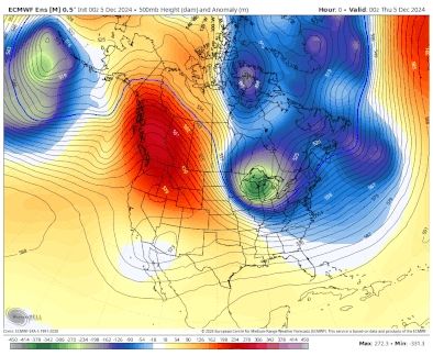
Pattern across the Eastern United States will slowly shift milder starting this weekend and into next week. Long range ensembles show central US trough by Christmas week. Will this start to migrate East in upcoming model depictions signifying another period of cold?
December 5, 2024 at 10:14 PM
Pattern across the Eastern United States will slowly shift milder starting this weekend and into next week. Long range ensembles show central US trough by Christmas week. Will this start to migrate East in upcoming model depictions signifying another period of cold?
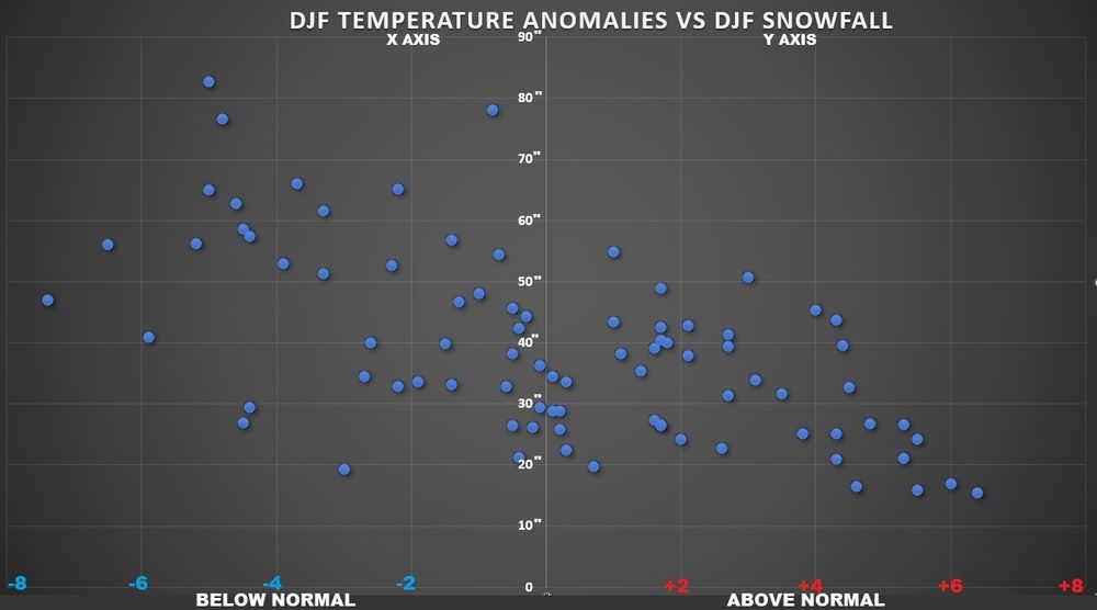
Here's a plot of avg temperature departures for NE Ohio December- February last 60 yrs. Y-axis is total snowfall DJF. Left on x-axis below normal temps. Right above normal temps. Above normal Ts strongly correlate to low snowfall. Relationship is more scattered with colder temps
December 5, 2024 at 9:51 PM
Here's a plot of avg temperature departures for NE Ohio December- February last 60 yrs. Y-axis is total snowfall DJF. Left on x-axis below normal temps. Right above normal temps. Above normal Ts strongly correlate to low snowfall. Relationship is more scattered with colder temps
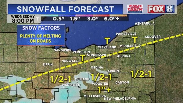
Before the lake effect begins late Friday, next system late tomorrow evening/tomorrow night. Any rain and snow accumulation would be mainly between midnight and 7:00 a.m. Thanksgiving. Rest of Thanksgiving looks much better with temperatures near 40°
November 26, 2024 at 5:24 PM
Before the lake effect begins late Friday, next system late tomorrow evening/tomorrow night. Any rain and snow accumulation would be mainly between midnight and 7:00 a.m. Thanksgiving. Rest of Thanksgiving looks much better with temperatures near 40°
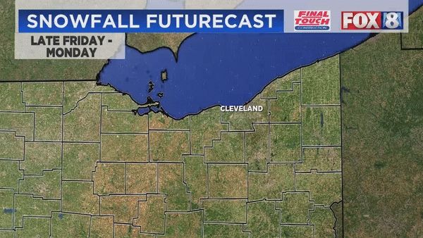
Based upon a more westerly fetch starting late Friday through early next week, these are the areas that will receive the most snow. Notice no numbers on this map yet. Way too early to pinpoint with hyper local accuracy. See my previous post on the lake effect parameters
November 26, 2024 at 5:22 PM
Based upon a more westerly fetch starting late Friday through early next week, these are the areas that will receive the most snow. Notice no numbers on this map yet. Way too early to pinpoint with hyper local accuracy. See my previous post on the lake effect parameters
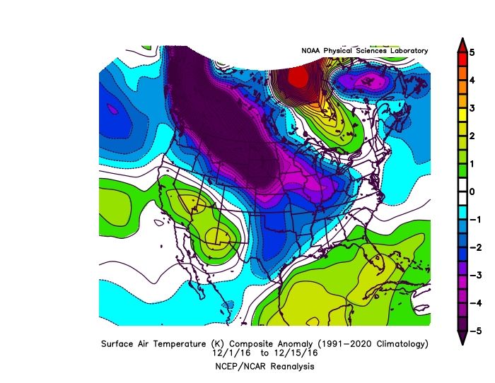
The last time we had below normal temperatures the first half of December in northern Ohio was 2016 & 2017. Here's a snapshot of what 2016 looked like across North America.
November 26, 2024 at 5:07 PM
The last time we had below normal temperatures the first half of December in northern Ohio was 2016 & 2017. Here's a snapshot of what 2016 looked like across North America.
The last time we had a 6-day stretch between 11-24 thru 12-7 as cold as what we're going to see in Northern Ohio starting this weekend into next week was in 2010!
November 26, 2024 at 5:04 PM
The last time we had a 6-day stretch between 11-24 thru 12-7 as cold as what we're going to see in Northern Ohio starting this weekend into next week was in 2010!
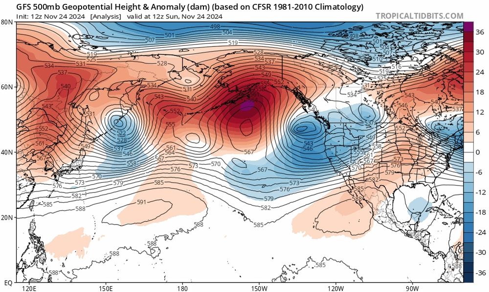
Another vantage point showing the cold draining Southeast into the heart of North America late this week and into the weekend
November 25, 2024 at 4:54 PM
Another vantage point showing the cold draining Southeast into the heart of North America late this week and into the weekend
We needed the pattern to shift allowing for the cold to transfer over the pole and into central Canada. Notice the big Ridge over Alaska and the Bering Sea?
November 25, 2024 at 4:53 PM
We needed the pattern to shift allowing for the cold to transfer over the pole and into central Canada. Notice the big Ridge over Alaska and the Bering Sea?
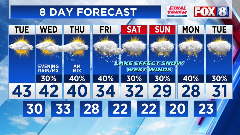
Here's the 8-day forecast through the end of next week. Although we get a break from the cold Sunday and Monday, it reloads Thanksgiving weekend. Higher probability for Lake effect snow. Stay tuned
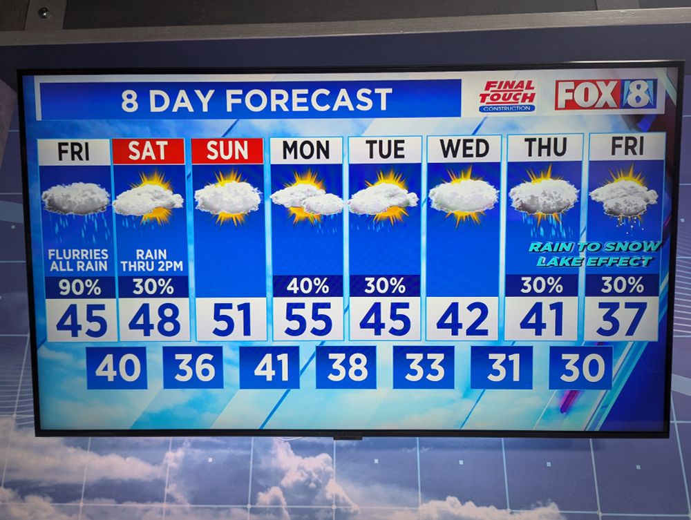
November 22, 2024 at 7:16 PM
Here's the 8-day forecast through the end of next week. Although we get a break from the cold Sunday and Monday, it reloads Thanksgiving weekend. Higher probability for Lake effect snow. Stay tuned
Friday morning radar 7:30 a.m. The Northern Ohio
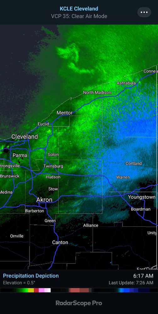
November 22, 2024 at 12:27 PM
Friday morning radar 7:30 a.m. The Northern Ohio
I was going through some old photos I took years ago. Here's one from Nicaragua. Enjoy on this cloudy and snowy evening

November 22, 2024 at 12:02 AM
I was going through some old photos I took years ago. Here's one from Nicaragua. Enjoy on this cloudy and snowy evening
A large band of moderate to heavy lake effect snow is moving Southeast. Expect its arrival in Cleveland and in the western suburbs back into Lorain County between 7:30 and 8:30
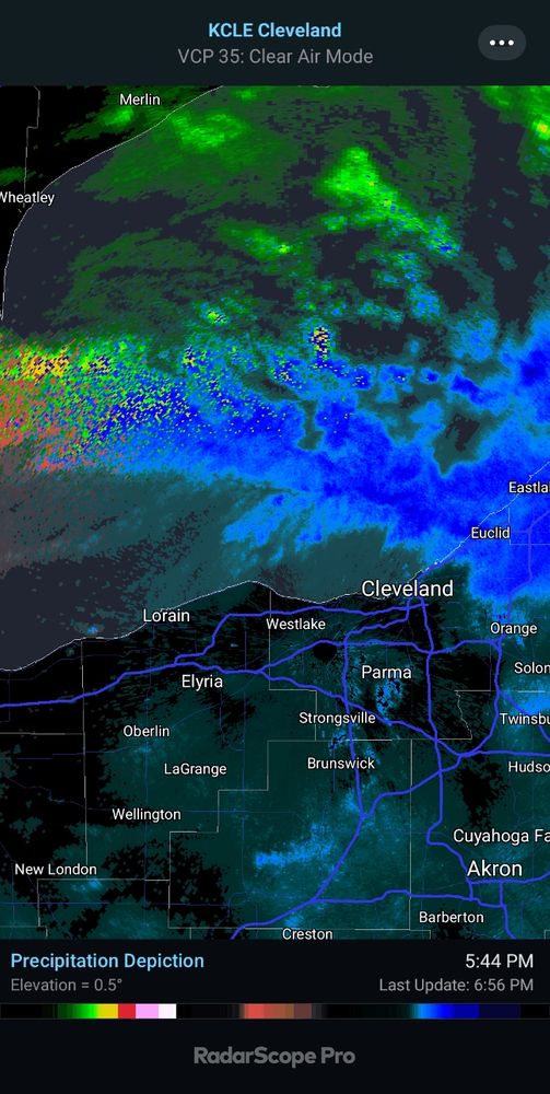
November 21, 2024 at 11:58 PM
A large band of moderate to heavy lake effect snow is moving Southeast. Expect its arrival in Cleveland and in the western suburbs back into Lorain County between 7:30 and 8:30
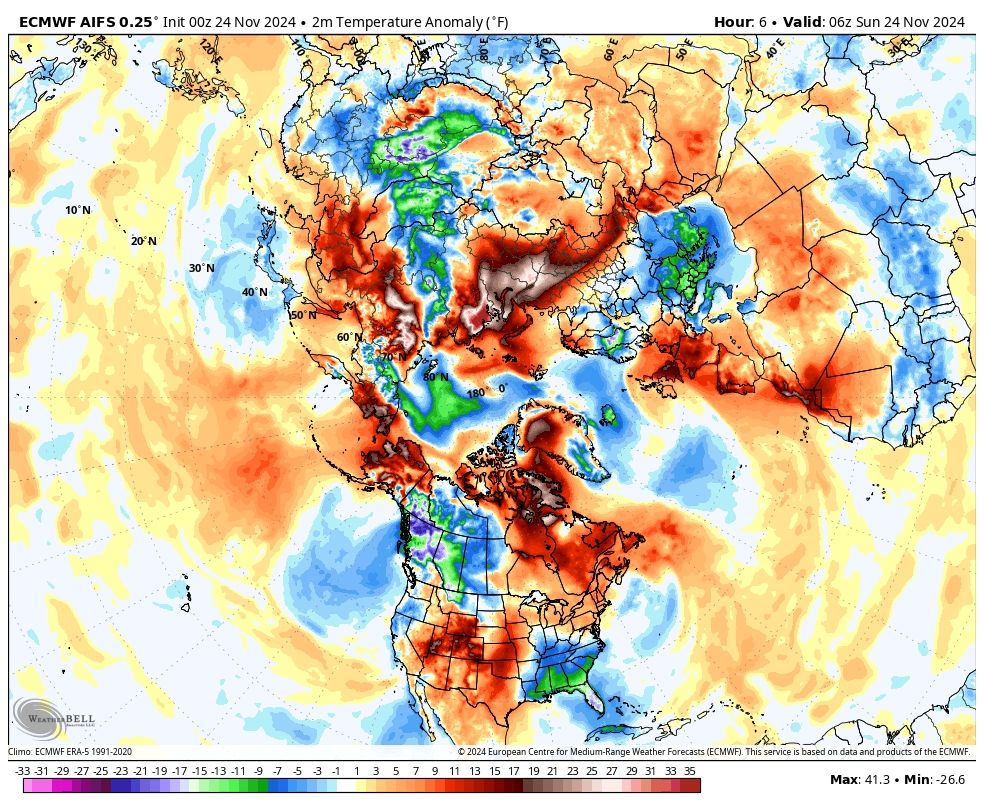
General circulation across the northern hemisphere with ridge and trough positions driving the currently colder eastern US. Will this establish itself heading into early December?
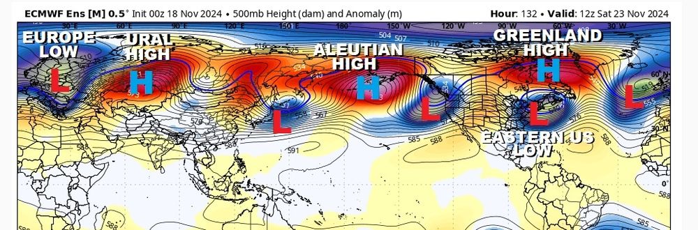
November 21, 2024 at 1:55 PM
General circulation across the northern hemisphere with ridge and trough positions driving the currently colder eastern US. Will this establish itself heading into early December?
Here is a look at Northern Ohio temperatures each day vs average since September 15th. Red days are above normal. Blue days have been below normal.
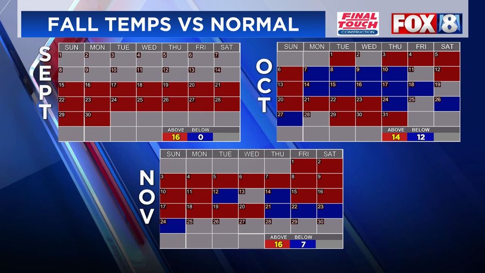
November 19, 2024 at 7:20 PM
Here is a look at Northern Ohio temperatures each day vs average since September 15th. Red days are above normal. Blue days have been below normal.