


Samuel Camp WX
@samuelcampwx.bsky.social
Weather Content Manager for @tnvalleyweather.com | Multi-Media Journalist for Live Storms Media & X Sports Network | ESPN Video Production |🌪️=3 | University of North Alabama 28’
https://linktr.ee/samuelcamp_wx
https://linktr.ee/samuelcamp_wx
Definitely a system of some sort (winter or rain) is possible during the early to mid next week time frame. This is just something to watch for trends at this time to see if there is another winter threat for the area.
#alwx #mswx #tnwx #tnvalleyweather
#alwx #mswx #tnwx #tnvalleyweather

January 12, 2025 at 6:42 PM
Definitely a system of some sort (winter or rain) is possible during the early to mid next week time frame. This is just something to watch for trends at this time to see if there is another winter threat for the area.
#alwx #mswx #tnwx #tnvalleyweather
#alwx #mswx #tnwx #tnvalleyweather
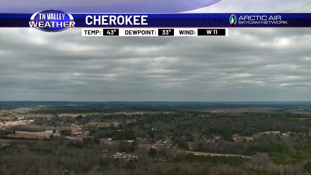
The snow is beginning to melt away again this morning as sunshine prevails and temps rise above freezing across the valley. A few slick spots remain on some of the back roads and highways but most of that should melt today with highs in the lower 40s.
#alwx #tnwx #mswx #tnvalleyweather
#alwx #tnwx #mswx #tnvalleyweather

January 12, 2025 at 4:13 PM
The snow is beginning to melt away again this morning as sunshine prevails and temps rise above freezing across the valley. A few slick spots remain on some of the back roads and highways but most of that should melt today with highs in the lower 40s.
#alwx #tnwx #mswx #tnvalleyweather
#alwx #tnwx #mswx #tnvalleyweather
Final Look: Model data continues to move back and forth late tonight. Data over the past 24 hours suggested that warmer air would try to move north into part of our area, causing more sleet and ice issues while lowering snow totals. Model data tonight, however, has shifted slightly back.
#alwx #tnwx
#alwx #tnwx


January 10, 2025 at 4:34 AM
It's pretty rough out in Little Rock, AR, this afternoon. 👀

January 9, 2025 at 9:58 PM
It's pretty rough out in Little Rock, AR, this afternoon. 👀
We are now getting into the range of the high-resolution HRRR model data that goes as far out as noon on Friday and the high-resolution NAM data that goes as far out as early Saturday. Both models are showing 2-4+ inches of snow area-wide by noon on Friday while snow is still falling.
#alwx #tnwx
#alwx #tnwx
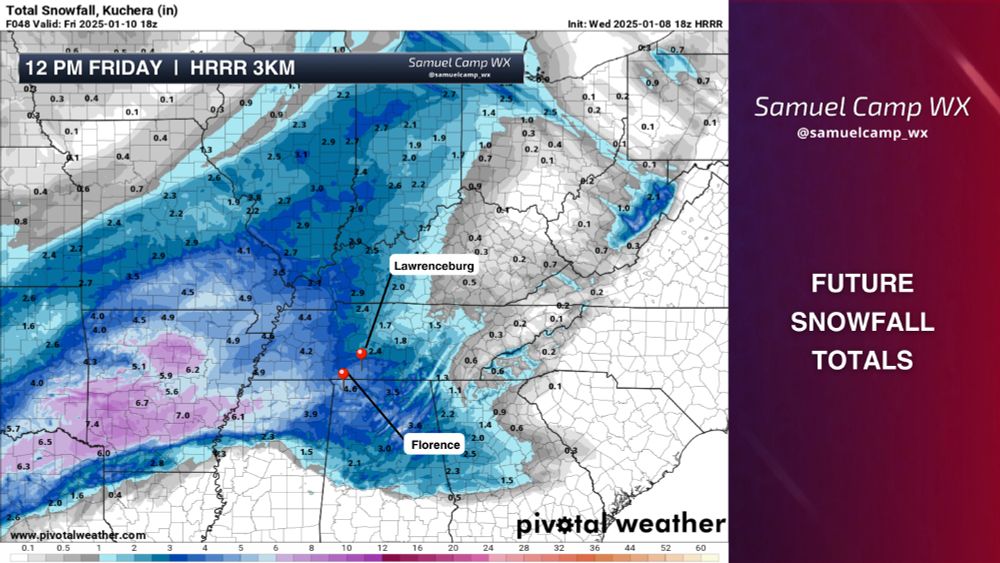

January 8, 2025 at 7:59 PM
Is this the best y'all can do? A winter storm is coming, and over half of Lexington’s milk supply is still on the shelfs. 😭

January 8, 2025 at 3:48 AM
Is this the best y'all can do? A winter storm is coming, and over half of Lexington’s milk supply is still on the shelfs. 😭

January 6, 2025 at 10:34 PM
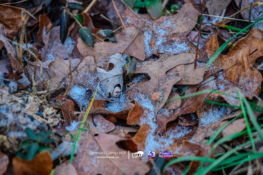
This is the most snow I could find on the ground at the studios in Lawrenceburg. Did anyone else get snow today?
#alwx #tnwx #mswx #tnvalleyweather
#alwx #tnwx #mswx #tnvalleyweather
January 6, 2025 at 7:52 PM
This is the most snow I could find on the ground at the studios in Lawrenceburg. Did anyone else get snow today?
#alwx #tnwx #mswx #tnvalleyweather
#alwx #tnwx #mswx #tnvalleyweather

A possible tornado touched down just a few minutes ago in the Vina, AL community in extreme west Alabama.
#alwx #tnvalleyweather
#alwx #tnvalleyweather

January 6, 2025 at 2:05 AM
A possible tornado touched down just a few minutes ago in the Vina, AL community in extreme west Alabama.
#alwx #tnvalleyweather
#alwx #tnvalleyweather


January 3, 2025 at 11:44 PM
Looking back through hundreds of different pictures from this past year, I would have to say that this picture of the Northern Lights visible on October 10th, 2024, would be my favorite.
📍Central Heights, AL
#alwx #tnvalleyweather
📍Central Heights, AL
#alwx #tnvalleyweather

January 2, 2025 at 6:57 PM
Looking back through hundreds of different pictures from this past year, I would have to say that this picture of the Northern Lights visible on October 10th, 2024, would be my favorite.
📍Central Heights, AL
#alwx #tnvalleyweather
📍Central Heights, AL
#alwx #tnvalleyweather
Is there the possibility of a few snowflakes or sleet falling sometime around then? Yes. Will a "MASSIVE WINTER STORM" occur in our area early next week? No.
More info on my Facebook and X account.
More info on my Facebook and X account.


January 1, 2025 at 10:35 PM
Is there the possibility of a few snowflakes or sleet falling sometime around then? Yes. Will a "MASSIVE WINTER STORM" occur in our area early next week? No.
More info on my Facebook and X account.
More info on my Facebook and X account.
Temps are cooler this afternoon compared to the past few days, with temps in the 40s all across the Tennessee Valley. Daily highs in the 40s and lows in the 20s will continue until a more significant cooldown occurs early next week, dropping highs into the 30s.
#alwx #tnwx #mswx #tnvalleyweathwer
#alwx #tnwx #mswx #tnvalleyweathwer
January 1, 2025 at 6:06 PM
Temps are cooler this afternoon compared to the past few days, with temps in the 40s all across the Tennessee Valley. Daily highs in the 40s and lows in the 20s will continue until a more significant cooldown occurs early next week, dropping highs into the 30s.
#alwx #tnwx #mswx #tnvalleyweathwer
#alwx #tnwx #mswx #tnvalleyweathwer
Happy New Year everyone!

January 1, 2025 at 5:59 AM
Happy New Year everyone!
A 30-ish-degree temperature difference is being modeled between the EURO and the GFS for early next week's storm system. While the GFS shows freezing rain with temperatures in the 20s and 30s, the EURO shows rain and thunderstorms with temperatures in the 60s area-wide.
#alwx #tnwx #mswx
#alwx #tnwx #mswx


December 31, 2024 at 7:09 PM
Here are a few images this morning out of Downtown Athens, AL where a likely tornado tracked through the area. I will be out surveying and documenting the damage this afternoon. NWS HSV is out surveying the area this morning as well.
📸- City of Athens, AL (Public Relations)
#alwx #tnvalleyweather
📸- City of Athens, AL (Public Relations)
#alwx #tnvalleyweather


December 29, 2024 at 4:00 PM
Here are a few images this morning out of Downtown Athens, AL where a likely tornado tracked through the area. I will be out surveying and documenting the damage this afternoon. NWS HSV is out surveying the area this morning as well.
📸- City of Athens, AL (Public Relations)
#alwx #tnvalleyweather
📸- City of Athens, AL (Public Relations)
#alwx #tnvalleyweather
I will be headed to survey this afternoon what appears to be a possible tornado track from tonight's storms through downtown Athens, AL.
📸- Limestone County EMA / UAH ARMOR Radar
#alwx #tnvalleyweather
📸- Limestone County EMA / UAH ARMOR Radar
#alwx #tnvalleyweather


December 29, 2024 at 7:36 AM
I will be headed to survey this afternoon what appears to be a possible tornado track from tonight's storms through downtown Athens, AL.
📸- Limestone County EMA / UAH ARMOR Radar
#alwx #tnvalleyweather
📸- Limestone County EMA / UAH ARMOR Radar
#alwx #tnvalleyweather
A Moderate Risk (4/5) remains in place for parts of Louisiana, Texas, Mississippi, Alabama, and Arkansas through tonight. Several tornadoes (some of which significant) damage winds, and large hail are all possible through tonight across the risk area.
#alwx #mswx #txwx #lawx #arwx
#alwx #mswx #txwx #lawx #arwx

December 28, 2024 at 8:01 PM
Our thinking locally has not changed. We are remaining CAUTIOUS for your safety and are monitoring the POSSIBILITY of a few severe storms with 50-65 mph winds or a tornado threat overnight tonight. We will STILL be staffed and ready to provide live coverage
#tnvalleyweather #tnwx #alwx #mswx
#tnvalleyweather #tnwx #alwx #mswx

December 28, 2024 at 2:50 PM
Our thinking locally has not changed. We are remaining CAUTIOUS for your safety and are monitoring the POSSIBILITY of a few severe storms with 50-65 mph winds or a tornado threat overnight tonight. We will STILL be staffed and ready to provide live coverage
#tnvalleyweather #tnwx #alwx #mswx
#tnvalleyweather #tnwx #alwx #mswx
A few severe storms are possible tomorrow evening and into the overnight hours after daytime highs climb into the upper 60s. Behind the front, temps will level into the lower 60s for Sunday and Monday before dropping back into the 50s and 40s on Tuesday.
#alwx #tnwx #mswx #tnvalleyweather
#alwx #tnwx #mswx #tnvalleyweather

December 27, 2024 at 9:47 PM
A few severe storms are possible tomorrow evening and into the overnight hours after daytime highs climb into the upper 60s. Behind the front, temps will level into the lower 60s for Sunday and Monday before dropping back into the 50s and 40s on Tuesday.
#alwx #tnwx #mswx #tnvalleyweather
#alwx #tnwx #mswx #tnvalleyweather
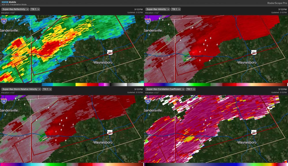
TDS just to the west of Waynesboro in southeast Mississippi this afternoon. Tornado warning continues till 3:45 pm for Wayne County, MS.
#mswx
#mswx
December 27, 2024 at 9:15 PM
TDS just to the west of Waynesboro in southeast Mississippi this afternoon. Tornado warning continues till 3:45 pm for Wayne County, MS.
#mswx
#mswx
