


Ice Cream O'Clock
@ryanoneil.bsky.social
Nerd and geek, ADHD, GIS
he/him
he/him
#30DayMapChallenge
Day 14: OpenStreetMap
My idea here is show how important colors (and font size) are important in making a good map 😀
Day 14: OpenStreetMap
My idea here is show how important colors (and font size) are important in making a good map 😀

November 14, 2025 at 11:43 PM
#30DayMapChallenge
Day 14: OpenStreetMap
My idea here is show how important colors (and font size) are important in making a good map 😀
Day 14: OpenStreetMap
My idea here is show how important colors (and font size) are important in making a good map 😀
#30DayMapChallenge
Day 13 10 minute map
I did briefly think about mapping 10 minutes, (10') but this was just much quicker 😀
Also, SO MANY DAMS! I knew there were a lot but goodness.
Day 13 10 minute map
I did briefly think about mapping 10 minutes, (10') but this was just much quicker 😀
Also, SO MANY DAMS! I knew there were a lot but goodness.

November 13, 2025 at 8:27 PM
#30DayMapChallenge
Day 13 10 minute map
I did briefly think about mapping 10 minutes, (10') but this was just much quicker 😀
Also, SO MANY DAMS! I knew there were a lot but goodness.
Day 13 10 minute map
I did briefly think about mapping 10 minutes, (10') but this was just much quicker 😀
Also, SO MANY DAMS! I knew there were a lot but goodness.

November 12, 2025 at 7:42 PM

November 12, 2025 at 7:40 PM

November 9, 2025 at 10:21 PM
#30DayMapChallenge
Day 8: Urban
This is a map of urban areas in the US -- 500 or more people per square mile. About 260 million of about 340 million Americans live in urban areas.
Day 8: Urban
This is a map of urban areas in the US -- 500 or more people per square mile. About 260 million of about 340 million Americans live in urban areas.

November 8, 2025 at 8:56 PM
#30DayMapChallenge
Day 8: Urban
This is a map of urban areas in the US -- 500 or more people per square mile. About 260 million of about 340 million Americans live in urban areas.
Day 8: Urban
This is a map of urban areas in the US -- 500 or more people per square mile. About 260 million of about 340 million Americans live in urban areas.
#30DayMapChallenge
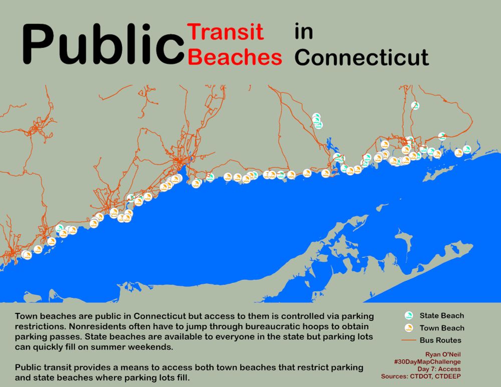
Day 7: Accessibility
Town beaches in Connecticut are notorious for restricting access for nonresidents via restricting access to parking passes. Parking lots at states often fill quickly on summer weekends.
Enter public transit.
Day 7: Accessibility
Town beaches in Connecticut are notorious for restricting access for nonresidents via restricting access to parking passes. Parking lots at states often fill quickly on summer weekends.
Enter public transit.
November 7, 2025 at 3:34 PM
#30DayMapChallenge
Day 7: Accessibility
Town beaches in Connecticut are notorious for restricting access for nonresidents via restricting access to parking passes. Parking lots at states often fill quickly on summer weekends.
Enter public transit.
Day 7: Accessibility
Town beaches in Connecticut are notorious for restricting access for nonresidents via restricting access to parking passes. Parking lots at states often fill quickly on summer weekends.
Enter public transit.
#30DayMapChallenge
Day 6: Dimensions
I used time as the dimension here. Looking at the racial segregation in the Greater Hartford area in 1980 and 2020. Interesting to see how People of Color moved into Bloomfield, Windsor, and East Hartford (and Manchester a little bit) but no other towns.
Day 6: Dimensions
I used time as the dimension here. Looking at the racial segregation in the Greater Hartford area in 1980 and 2020. Interesting to see how People of Color moved into Bloomfield, Windsor, and East Hartford (and Manchester a little bit) but no other towns.

November 6, 2025 at 3:25 PM
#30DayMapChallenge
Day 6: Dimensions
I used time as the dimension here. Looking at the racial segregation in the Greater Hartford area in 1980 and 2020. Interesting to see how People of Color moved into Bloomfield, Windsor, and East Hartford (and Manchester a little bit) but no other towns.
Day 6: Dimensions
I used time as the dimension here. Looking at the racial segregation in the Greater Hartford area in 1980 and 2020. Interesting to see how People of Color moved into Bloomfield, Windsor, and East Hartford (and Manchester a little bit) but no other towns.

November 5, 2025 at 7:04 PM
Outside right now. Thanks a lot, Standard Time

November 4, 2025 at 9:36 PM
Outside right now. Thanks a lot, Standard Time

November 4, 2025 at 1:32 PM
Day 3: Polygons
Comparing the size of some US states and national parks and then a few other geographic units including Greenland and Africa.
Also first time making an animated GIF 🙂
#30DayMapChallenge
Comparing the size of some US states and national parks and then a few other geographic units including Greenland and Africa.
Also first time making an animated GIF 🙂
#30DayMapChallenge
November 3, 2025 at 5:06 PM
Day 3: Polygons
Comparing the size of some US states and national parks and then a few other geographic units including Greenland and Africa.
Also first time making an animated GIF 🙂
#30DayMapChallenge
Comparing the size of some US states and national parks and then a few other geographic units including Greenland and Africa.
Also first time making an animated GIF 🙂
#30DayMapChallenge
#30DayMapChallenge
Day 2: Lines
The state route numbers in CT aren't laid out systematically like Interstate numbers 😀
Day 2: Lines
The state route numbers in CT aren't laid out systematically like Interstate numbers 😀

November 2, 2025 at 3:06 PM
#30DayMapChallenge
Day 2: Lines
The state route numbers in CT aren't laid out systematically like Interstate numbers 😀
Day 2: Lines
The state route numbers in CT aren't laid out systematically like Interstate numbers 😀
@lyndacarter.bsky.social Here's my wife in 2012 as Wonder Woman. She made the costume herself (along with a George Reeves B&W Superman costume for me).
She's only become superheroic in the time since 🥰
She's only become superheroic in the time since 🥰

November 1, 2025 at 10:43 PM
@lyndacarter.bsky.social Here's my wife in 2012 as Wonder Woman. She made the costume herself (along with a George Reeves B&W Superman costume for me).
She's only become superheroic in the time since 🥰
She's only become superheroic in the time since 🥰
#30DayMapChallenge
Day 1: Points
County-level population in Ireland (excluding Northern Ireland) from 1841 (prior to the Great Hunger) through 2022
Day 1: Points
County-level population in Ireland (excluding Northern Ireland) from 1841 (prior to the Great Hunger) through 2022

November 1, 2025 at 3:40 PM
#30DayMapChallenge
Day 1: Points
County-level population in Ireland (excluding Northern Ireland) from 1841 (prior to the Great Hunger) through 2022
Day 1: Points
County-level population in Ireland (excluding Northern Ireland) from 1841 (prior to the Great Hunger) through 2022
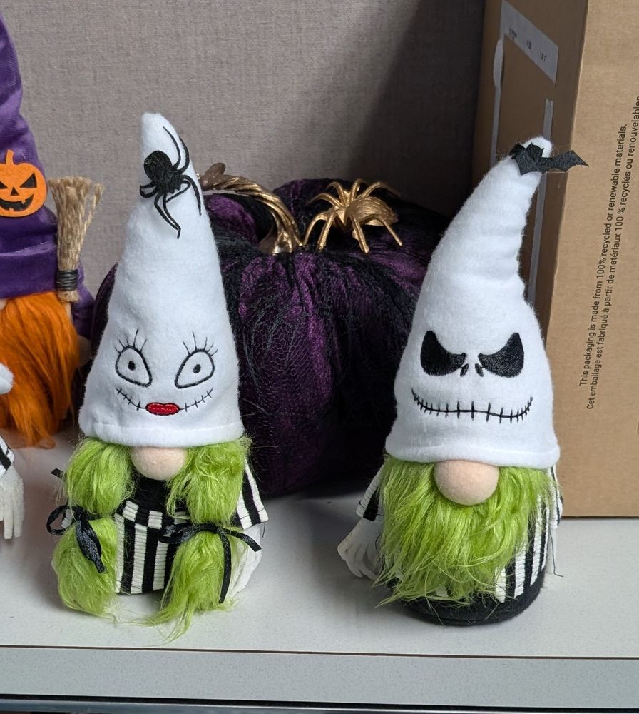
I get what they were going for if they were going for "gnomes in the Klan celebrating Halloween"
October 28, 2025 at 12:47 PM
I get what they were going for if they were going for "gnomes in the Klan celebrating Halloween"
Okay, here's a nice autumn tree to make up for that joke

October 24, 2025 at 8:58 PM
Okay, here's a nice autumn tree to make up for that joke
Much easier to catch than those fast bumps

October 16, 2025 at 11:00 AM
Much easier to catch than those fast bumps
Wearing this sweater
Also, hanging my jacket on the outside of my cube, putting something on top of the cube shelving cabinet
Also, hanging my jacket on the outside of my cube, putting something on top of the cube shelving cabinet

May 19, 2025 at 4:26 PM
Wearing this sweater
Also, hanging my jacket on the outside of my cube, putting something on top of the cube shelving cabinet
Also, hanging my jacket on the outside of my cube, putting something on top of the cube shelving cabinet


POST A FICTIONAL CHARACTER WHO U THINK WULD BE A ANTIVAXXER
HARD MODE: NO VILLAINS
HARD MODE: NO VILLAINS

March 20, 2025 at 2:46 AM
POST A FICTIONAL CHARACTER WHO U THINK WULD BE A ANTIVAXXER
HARD MODE: NO VILLAINS
HARD MODE: NO VILLAINS
The Gulf of Bluey. She would be so excited! "For real life?!"

February 19, 2025 at 7:55 PM
The Gulf of Bluey. She would be so excited! "For real life?!"
Lollipops used to be bigger. That's why Trump won.
Can all of these dumb assholes move to their own country, please?
Can all of these dumb assholes move to their own country, please?

February 6, 2025 at 4:43 PM
Lollipops used to be bigger. That's why Trump won.
Can all of these dumb assholes move to their own country, please?
Can all of these dumb assholes move to their own country, please?
