


@remcrowder.bsky.social
Severe Thunderstorm Warning for...
Northeastern Gibson County in southwestern Indiana...
Pike County in southwestern Indiana...
* Until 845 PM CDT/945 PM EDT/.
Northeastern Gibson County in southwestern Indiana...
Pike County in southwestern Indiana...
* Until 845 PM CDT/945 PM EDT/.

August 13, 2025 at 1:02 AM
Severe Thunderstorm Warning for...
Northeastern Gibson County in southwestern Indiana...
Pike County in southwestern Indiana...
* Until 845 PM CDT/945 PM EDT/.
Northeastern Gibson County in southwestern Indiana...
Pike County in southwestern Indiana...
* Until 845 PM CDT/945 PM EDT/.
Severe Thunderstorm Warning for...
West central Warrick County in southwestern Indiana...
Northeastern Vanderburgh County in southwestern Indiana...
* Until 815 PM CDT.
West central Warrick County in southwestern Indiana...
Northeastern Vanderburgh County in southwestern Indiana...
* Until 815 PM CDT.

August 13, 2025 at 12:49 AM
Severe Thunderstorm Warning for...
West central Warrick County in southwestern Indiana...
Northeastern Vanderburgh County in southwestern Indiana...
* Until 815 PM CDT.
West central Warrick County in southwestern Indiana...
Northeastern Vanderburgh County in southwestern Indiana...
* Until 815 PM CDT.
When Taylor announces a new album and the AP gives it the “Breaking” tag, you know she is powerful.

August 12, 2025 at 4:51 AM
When Taylor announces a new album and the AP gives it the “Breaking” tag, you know she is powerful.
Severe Thunderstorm Warning for...
Southwestern Spencer County in southwestern Indiana...
Daviess County in northwestern Kentucky...
East central Henderson County in northwestern Kentucky...
* Until 830 PM CDT.
Southwestern Spencer County in southwestern Indiana...
Daviess County in northwestern Kentucky...
East central Henderson County in northwestern Kentucky...
* Until 830 PM CDT.

July 29, 2025 at 12:52 AM
Severe Thunderstorm Warning for...
Southwestern Spencer County in southwestern Indiana...
Daviess County in northwestern Kentucky...
East central Henderson County in northwestern Kentucky...
* Until 830 PM CDT.
Southwestern Spencer County in southwestern Indiana...
Daviess County in northwestern Kentucky...
East central Henderson County in northwestern Kentucky...
* Until 830 PM CDT.
Severe Thunderstorm Warning for...
Central Knox County in southwestern Indiana...
Southwestern Daviess County in southwestern Indiana...
* Until 800 PM EDT.
Central Knox County in southwestern Indiana...
Southwestern Daviess County in southwestern Indiana...
* Until 800 PM EDT.

July 28, 2025 at 11:21 PM
Severe Thunderstorm Warning for...
Central Knox County in southwestern Indiana...
Southwestern Daviess County in southwestern Indiana...
* Until 800 PM EDT.
Central Knox County in southwestern Indiana...
Southwestern Daviess County in southwestern Indiana...
* Until 800 PM EDT.
Heat Advisory is in effect from Saturday afternoon until Tuesday evening. Heat index values between 100 to 108 degrees are expected with the first heat wave of the season.

June 20, 2025 at 11:48 AM
Heat Advisory is in effect from Saturday afternoon until Tuesday evening. Heat index values between 100 to 108 degrees are expected with the first heat wave of the season.
Tornado Watch has been issued for parts of Illinois, Indiana, Kentucky and Missouri until 8 PM CDT

June 18, 2025 at 7:09 PM
Tornado Watch has been issued for parts of Illinois, Indiana, Kentucky and Missouri until 8 PM CDT
* Flash Flood Warning for... East Central Vanderburgh County in southwestern Indiana... Southwestern Warrick County in southwestern Indiana...
* Until midnight CDT tonight.
* Until midnight CDT tonight.

June 15, 2025 at 12:34 AM
* Flash Flood Warning for... East Central Vanderburgh County in southwestern Indiana... Southwestern Warrick County in southwestern Indiana...
* Until midnight CDT tonight.
* Until midnight CDT tonight.
FLASH FLOOD EMERGENCY for western Evansville including the Mechanicsville, Red Bank, Airport and Harwood neighborhoods until 10:15pm CT

June 13, 2025 at 11:18 PM
FLASH FLOOD EMERGENCY for western Evansville including the Mechanicsville, Red Bank, Airport and Harwood neighborhoods until 10:15pm CT
Severe Thunderstorm Warning including Evansville IN, Highland IN and Melody Hill IN until 4:45 PM CDT

June 13, 2025 at 9:19 PM
Severe Thunderstorm Warning including Evansville IN, Highland IN and Melody Hill IN until 4:45 PM CDT
Tornado Warning including Chrisney IN and Lamar IN until 5:45 PM CDT

June 7, 2025 at 9:58 PM
Tornado Warning including Chrisney IN and Lamar IN until 5:45 PM CDT
Tornado Watch has been issued for parts of Alabama, Georgia, Illinois, Indiana, Kentucky and Tennessee until 10 PM CDT

May 20, 2025 at 7:40 PM
Tornado Watch has been issued for parts of Alabama, Georgia, Illinois, Indiana, Kentucky and Tennessee until 10 PM CDT
Severe Thunderstorm Warning including Evansville IN, Henderson KY and Mount Vernon IN until 8:45 PM CDT. This storm will contain wind gusts to 70 MPH!
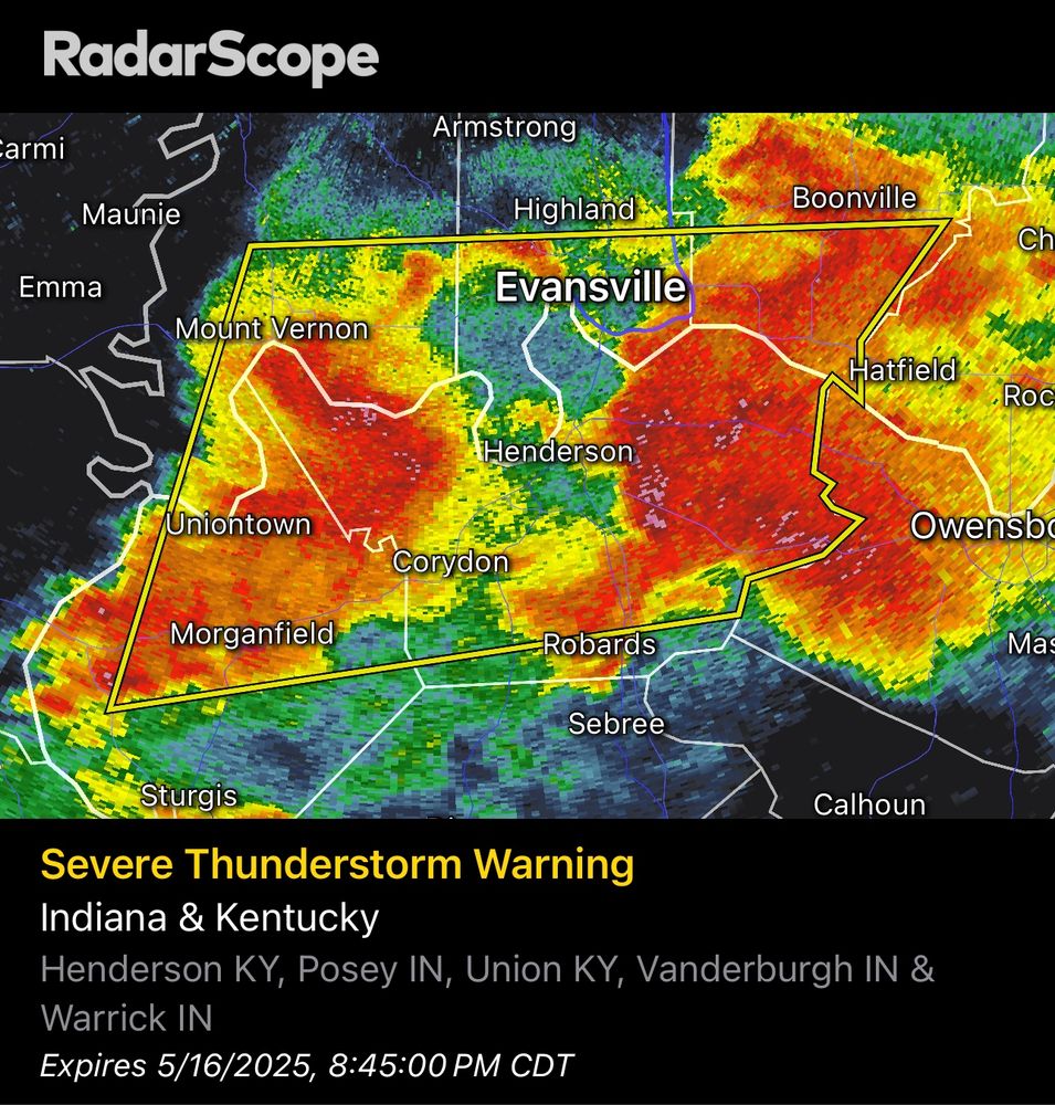
May 17, 2025 at 12:55 AM
Severe Thunderstorm Warning including Evansville IN, Henderson KY and Mount Vernon IN until 8:45 PM CDT. This storm will contain wind gusts to 70 MPH!
Union County EMA confirmed tornado southwest of Morganfield #tristatewx

May 17, 2025 at 12:28 AM
Union County EMA confirmed tornado southwest of Morganfield #tristatewx
Tornado Warning including Henderson KY, Morganfield KY and Shawneetown IL until 8:00 PM CDT

May 17, 2025 at 12:16 AM
Tornado Warning including Henderson KY, Morganfield KY and Shawneetown IL until 8:00 PM CDT
Tornado Emergency including Marion IL, Harrisburg IL and Carrier Mills IL until 7:00 PM CDT


May 16, 2025 at 11:28 PM
Tornado Emergency including Marion IL, Harrisburg IL and Carrier Mills IL until 7:00 PM CDT
Severe Thunderstorm Warning including Norris City IL, Poseyville IN and New Harmony IN until 7:00 PM CDT

May 16, 2025 at 11:19 PM
Severe Thunderstorm Warning including Norris City IL, Poseyville IN and New Harmony IN until 7:00 PM CDT
Tornado Warning including Princeton KY, Dawson Springs KY and Eddyville KY until 6:15 PM CDT

May 16, 2025 at 10:36 PM
Tornado Warning including Princeton KY, Dawson Springs KY and Eddyville KY until 6:15 PM CDT
A tornado watch has been issued for parts of Illinois, Indiana, Kentucky and Missouri until 10 PM CDT

May 16, 2025 at 8:12 PM
A tornado watch has been issued for parts of Illinois, Indiana, Kentucky and Missouri until 10 PM CDT

A severe thunderstorm watch has been issued for parts of Illinois, Indiana and Kentucky until 8 PM CDT

April 29, 2025 at 6:34 PM
A severe thunderstorm watch has been issued for parts of Illinois, Indiana and Kentucky until 8 PM CDT
NWS Paducah radar estimates about 12” has fallen since 11AM WEDNESDAY over Mayfield and Benton

April 5, 2025 at 10:46 PM
NWS Paducah radar estimates about 12” has fallen since 11AM WEDNESDAY over Mayfield and Benton
Flash Flood Warning including Evansville IN, Owensboro KY and Boonville IN until 8:45 PM CDT

April 5, 2025 at 7:53 PM
Flash Flood Warning including Evansville IN, Owensboro KY and Boonville IN until 8:45 PM CDT
Green is Flash Flood Warnings

April 5, 2025 at 3:57 AM
Green is Flash Flood Warnings
Flash Flood Warning including Evansville IN, Princeton IN and Mount Vernon IN until 4:45 AM CDT

April 5, 2025 at 3:48 AM
Flash Flood Warning including Evansville IN, Princeton IN and Mount Vernon IN until 4:45 AM CDT