


PΞTΞ
@rearflank.bsky.social
Hurricane #Melissa made landfall over Jamaica as a category 5 with wind of 185mph.
With a pressure of 892 millibars, it is now tied as the 3rd strongest hurricane ever in the Atlantic. It is also the strongest hurricane to ever hit Jamaica
With a pressure of 892 millibars, it is now tied as the 3rd strongest hurricane ever in the Atlantic. It is also the strongest hurricane to ever hit Jamaica
October 28, 2025 at 5:34 PM
Hurricane #Melissa made landfall over Jamaica as a category 5 with wind of 185mph.
With a pressure of 892 millibars, it is now tied as the 3rd strongest hurricane ever in the Atlantic. It is also the strongest hurricane to ever hit Jamaica
With a pressure of 892 millibars, it is now tied as the 3rd strongest hurricane ever in the Atlantic. It is also the strongest hurricane to ever hit Jamaica
October 10, 2025 at 2:13 AM
We are starting to see a few storms firing up now in PA and North Jersey.
South Jersey remains dry through at least 5:00. Strong storms are likely late afternoon and tonight.
#NJwx
South Jersey remains dry through at least 5:00. Strong storms are likely late afternoon and tonight.
#NJwx
September 6, 2025 at 5:02 PM
We are starting to see a few storms firing up now in PA and North Jersey.
South Jersey remains dry through at least 5:00. Strong storms are likely late afternoon and tonight.
#NJwx
South Jersey remains dry through at least 5:00. Strong storms are likely late afternoon and tonight.
#NJwx
Hurricane Erin has now strengthened into a category 5 with wind of 160mph.
The last category 5 in the Atlantic was Milton in October 2024.
The last category 5 in the Atlantic was Milton in October 2024.


August 16, 2025 at 3:25 PM
Hurricane Erin has now strengthened into a category 5 with wind of 160mph.
The last category 5 in the Atlantic was Milton in October 2024.
The last category 5 in the Atlantic was Milton in October 2024.
#Erin became a hurricane this morning — the first hurricane this season.
It is expected to become a major hurricane by Sunday. No threat to the U.S.
It is expected to become a major hurricane by Sunday. No threat to the U.S.

August 15, 2025 at 8:57 PM
#Erin became a hurricane this morning — the first hurricane this season.
It is expected to become a major hurricane by Sunday. No threat to the U.S.
It is expected to become a major hurricane by Sunday. No threat to the U.S.
Tropical Storm #Erin has formed in the Atlantic — making it the 5th named storm this season.
Models are forecasting that it will head west, but eventually turn north. No threat tor the U.S. at this time.
Models are forecasting that it will head west, but eventually turn north. No threat tor the U.S. at this time.


August 11, 2025 at 3:11 PM
Tropical Storm #Erin has formed in the Atlantic — making it the 5th named storm this season.
Models are forecasting that it will head west, but eventually turn north. No threat tor the U.S. at this time.
Models are forecasting that it will head west, but eventually turn north. No threat tor the U.S. at this time.
A beautiful start to the weekend as temps are in the 70s at the Shore and around 80 inland with low humidity.
We stay dry tomorrow and Sunday with sun and clouds. Mid to upper 80s for highs. Humidity stays low.
#NJwx
We stay dry tomorrow and Sunday with sun and clouds. Mid to upper 80s for highs. Humidity stays low.
#NJwx

August 8, 2025 at 7:30 PM
A beautiful start to the weekend as temps are in the 70s at the Shore and around 80 inland with low humidity.
We stay dry tomorrow and Sunday with sun and clouds. Mid to upper 80s for highs. Humidity stays low.
#NJwx
We stay dry tomorrow and Sunday with sun and clouds. Mid to upper 80s for highs. Humidity stays low.
#NJwx


Welcome to August, when hurricane season typically ramps up. The National Hurricane Center is watching 3 areas that could become tropical.
www.nhc.noaa.gov
www.nhc.noaa.gov

August 3, 2025 at 5:57 PM
Welcome to August, when hurricane season typically ramps up. The National Hurricane Center is watching 3 areas that could become tropical.
www.nhc.noaa.gov
www.nhc.noaa.gov
Good morning! It is feeling refreshing out there as temps are MUCH cooler from earlier this week. Highs stay in the 70s under cloudy skies. There could be drizzle in spots.
#NJwx
#NJwx

August 1, 2025 at 2:34 PM
Good morning! It is feeling refreshing out there as temps are MUCH cooler from earlier this week. Highs stay in the 70s under cloudy skies. There could be drizzle in spots.
#NJwx
#NJwx
The bulk of the rain will push out between 8p-midnight from west to east. Additional rain and storms could develop overnight at the Shore. Temps fall into the mid 60s by sunrise.
#NJwx
#NJwx
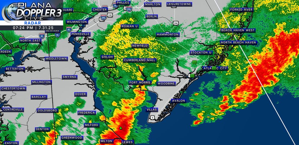
July 31, 2025 at 11:26 PM
The bulk of the rain will push out between 8p-midnight from west to east. Additional rain and storms could develop overnight at the Shore. Temps fall into the mid 60s by sunrise.
#NJwx
#NJwx
Heavy rain and thunderstorms will continue to move through South Jersey over the next couple of hours. Flash flooding is the biggest threat.
#NJwx
#NJwx
July 31, 2025 at 8:39 PM
Heavy rain and thunderstorms will continue to move through South Jersey over the next couple of hours. Flash flooding is the biggest threat.
#NJwx
#NJwx
Severe Thunderstorm Warning until 3:45p for parts of Salem, Camden , Gloucester county (NJ) Philly (PA)
60mph wind gusts and penny size hail possible
60mph wind gusts and penny size hail possible

July 31, 2025 at 6:58 PM
Severe Thunderstorm Warning until 3:45p for parts of Salem, Camden , Gloucester county (NJ) Philly (PA)
60mph wind gusts and penny size hail possible
60mph wind gusts and penny size hail possible
Flash flooding is becoming an issue along and I-95 and 295 in Salem, Gloucester, Camden and the Philly metro. If you are on the road, turn around when you see flooding. These storms could also produce frequent lightning, gusty winds and small hail.
#NJwx
#NJwx

July 31, 2025 at 6:49 PM
Flash flooding is becoming an issue along and I-95 and 295 in Salem, Gloucester, Camden and the Philly metro. If you are on the road, turn around when you see flooding. These storms could also produce frequent lightning, gusty winds and small hail.
#NJwx
#NJwx
Severe Thunderstorm WATCH until 8p tonight for all of South Jersey and Philly. Storms have the potential to produce frequent lightning, gusty winds and flooding.
#NJwx
#NJwx

July 31, 2025 at 5:27 PM
Severe Thunderstorm WATCH until 8p tonight for all of South Jersey and Philly. Storms have the potential to produce frequent lightning, gusty winds and flooding.
#NJwx
#NJwx
Widespread downpours and storms have developed across PA and MD. This will all slide eastward through the afternoon. Flash flooding will be the biggest issue along with frequent lightning and gusty winds. Stay alert for warnings.
#NJwx
#NJwx

July 31, 2025 at 4:44 PM
Widespread downpours and storms have developed across PA and MD. This will all slide eastward through the afternoon. Flash flooding will be the biggest issue along with frequent lightning and gusty winds. Stay alert for warnings.
#NJwx
#NJwx
Severe Thunderstorm WATCH coming soon to South Jersey. Storm Prediction Center is mentioning the potential for damaging wind and a tornado
#NJwx
#NJwx

July 31, 2025 at 3:36 PM
Severe Thunderstorm WATCH coming soon to South Jersey. Storm Prediction Center is mentioning the potential for damaging wind and a tornado
#NJwx
#NJwx
Good morning! Clouds build through midday with breaks of sun. Highs in the upper 80s. Rain and storms pop up after 3p. Flash flooding, lightning and gusty winds are possible. PLEASE stay alert for warnings and take action if your area is prone to flooding. Everything clears out by midnight.
#NJwx
#NJwx


July 31, 2025 at 1:09 PM
Good morning! Clouds build through midday with breaks of sun. Highs in the upper 80s. Rain and storms pop up after 3p. Flash flooding, lightning and gusty winds are possible. PLEASE stay alert for warnings and take action if your area is prone to flooding. Everything clears out by midnight.
#NJwx
#NJwx
It's another toasty day across South Jersey with temps in the 90s and a heat index over 100. Sun and clouds mix the rest of the day. Some clouds build in tonight. Watch for an isolated shower or thunderstorm
Heavy storms are likely tomorrow afternoon-night. Flooding and severe storms possible
#NJwx
Heavy storms are likely tomorrow afternoon-night. Flooding and severe storms possible
#NJwx

July 30, 2025 at 7:47 PM
It's another toasty day across South Jersey with temps in the 90s and a heat index over 100. Sun and clouds mix the rest of the day. Some clouds build in tonight. Watch for an isolated shower or thunderstorm
Heavy storms are likely tomorrow afternoon-night. Flooding and severe storms possible
#NJwx
Heavy storms are likely tomorrow afternoon-night. Flooding and severe storms possible
#NJwx
It's another warm and humid day with temps in the upper 80s. Skies will remain mostly cloudy with breaks of sun. Scattered downpours and thunderstorms are likely through sunset.
#NJwx
#NJwx

July 27, 2025 at 5:38 PM
It's another warm and humid day with temps in the upper 80s. Skies will remain mostly cloudy with breaks of sun. Scattered downpours and thunderstorms are likely through sunset.
#NJwx
#NJwx
Clouds are beginning to move in from the west. Skies will remain cloudy through the rest of today with breaks of sun. There could be a scattered shower or thunderstorm around later this afternoon into tonight.
#NJwx
#NJwx

July 26, 2025 at 7:53 PM
Clouds are beginning to move in from the west. Skies will remain cloudy through the rest of today with breaks of sun. There could be a scattered shower or thunderstorm around later this afternoon into tonight.
#NJwx
#NJwx


