


Pablo Valenzuela-Casasempere
@pvalenzuelac.bsky.social
I overcome these with three empirical strategies: 1) comparing displaced and adjacent individuals to their unaffected neighbors, 2) matching to potential controls living >2km of highways, and 3) digitizing 100 Federal highway plans and using those who would have been affected if the maps were built.

November 19, 2024 at 10:17 PM
I overcome these with three empirical strategies: 1) comparing displaced and adjacent individuals to their unaffected neighbors, 2) matching to potential controls living >2km of highways, and 3) digitizing 100 Federal highway plans and using those who would have been affected if the maps were built.
I tackle these challenges by developing a **novel way to identify and track people displaced** by highway construction. Using geocoded 1940 census addresses linked to the highway network, I follow residents across time using mortality records from 1995-2005 linked to the census

November 19, 2024 at 10:16 PM
I tackle these challenges by developing a **novel way to identify and track people displaced** by highway construction. Using geocoded 1940 census addresses linked to the highway network, I follow residents across time using mortality records from 1995-2005 linked to the census
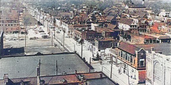
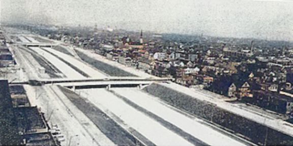
The Interstate Highway System (IHS) construction is ideal for studying these dynamics. Why? Over 4,500 km were built in cities with no relocation aid for displaced residents in its first decade.


November 19, 2024 at 10:15 PM
The Interstate Highway System (IHS) construction is ideal for studying these dynamics. Why? Over 4,500 km were built in cities with no relocation aid for displaced residents in its first decade.
How do major infrastructure projects reshape the lives of those displaced and those residing in affected communities? In my JMP, I answer this question in the context of the construction of the Interstate Highway System.🛣️🚧
A thread of my results 🧵🧵 #EconJMP
A thread of my results 🧵🧵 #EconJMP
November 19, 2024 at 10:14 PM
How do major infrastructure projects reshape the lives of those displaced and those residing in affected communities? In my JMP, I answer this question in the context of the construction of the Interstate Highway System.🛣️🚧
A thread of my results 🧵🧵 #EconJMP
A thread of my results 🧵🧵 #EconJMP