


Planetary Ecologist
@planetaryecologist.mastodon.social.ap.brid.gy
#bot that post twice a day a random #wikipedia page on biological and Earth sciences
"Kynes looked at Jessica, said: 'The newcomer to Arrakis […]
[bridged from https://mastodon.social/@planetaryecologist on the fediverse by https://fed.brid.gy/ ]
"Kynes looked at Jessica, said: 'The newcomer to Arrakis […]
[bridged from https://mastodon.social/@planetaryecologist on the fediverse by https://fed.brid.gy/ ]
Acoustic seabed classification (Oceanography 🌊)
Acoustic seabed classification is the partitioning of a seabed acoustic image into discrete physical entities or classes. This is a particularly active area of development in the field of seabed mapping, marine geophysics, underwater acoustics and […]
Acoustic seabed classification is the partitioning of a seabed acoustic image into discrete physical entities or classes. This is a particularly active area of development in the field of seabed mapping, marine geophysics, underwater acoustics and […]
Original post on mastodon.social
mastodon.social
December 27, 2025 at 7:09 AM
Acoustic seabed classification (Oceanography 🌊)
Acoustic seabed classification is the partitioning of a seabed acoustic image into discrete physical entities or classes. This is a particularly active area of development in the field of seabed mapping, marine geophysics, underwater acoustics and […]
Acoustic seabed classification is the partitioning of a seabed acoustic image into discrete physical entities or classes. This is a particularly active area of development in the field of seabed mapping, marine geophysics, underwater acoustics and […]
Lode (Mineralogy 💎)
In geology, a lode is a deposit of metalliferous ore that fills or is embedded in a fracture in a rock formation or a vein of ore that is deposited or embedded between layers of rock. The current meaning dates from the 17th century, being an expansion of an earlier sense of […]
In geology, a lode is a deposit of metalliferous ore that fills or is embedded in a fracture in a rock formation or a vein of ore that is deposited or embedded between layers of rock. The current meaning dates from the 17th century, being an expansion of an earlier sense of […]
Original post on mastodon.social
mastodon.social
December 26, 2025 at 7:09 PM
Lode (Mineralogy 💎)
In geology, a lode is a deposit of metalliferous ore that fills or is embedded in a fracture in a rock formation or a vein of ore that is deposited or embedded between layers of rock. The current meaning dates from the 17th century, being an expansion of an earlier sense of […]
In geology, a lode is a deposit of metalliferous ore that fills or is embedded in a fracture in a rock formation or a vein of ore that is deposited or embedded between layers of rock. The current meaning dates from the 17th century, being an expansion of an earlier sense of […]
Planosol (Pedology 🟤)
A Planosol in the World Reference Base for Soil Resources is a soil with a light-coloured, coarse-textured, surface horizon that shows signs of periodic water stagnation and abruptly overlies a dense, slowly permeable subsoil with significantly more clay than the surface […]
A Planosol in the World Reference Base for Soil Resources is a soil with a light-coloured, coarse-textured, surface horizon that shows signs of periodic water stagnation and abruptly overlies a dense, slowly permeable subsoil with significantly more clay than the surface […]
Original post on mastodon.social
mastodon.social
December 25, 2025 at 7:10 PM
Planosol (Pedology 🟤)
A Planosol in the World Reference Base for Soil Resources is a soil with a light-coloured, coarse-textured, surface horizon that shows signs of periodic water stagnation and abruptly overlies a dense, slowly permeable subsoil with significantly more clay than the surface […]
A Planosol in the World Reference Base for Soil Resources is a soil with a light-coloured, coarse-textured, surface horizon that shows signs of periodic water stagnation and abruptly overlies a dense, slowly permeable subsoil with significantly more clay than the surface […]
Resource fragmentation hypothesis (Zoology 🦥)
The resource fragmentation hypothesis was first proposed by Janzen & Pond, and says that as species richness becomes large there is not a linear increase in the number of parasitoid species that can be supported. The mechanism for this hyperbolic […]
The resource fragmentation hypothesis was first proposed by Janzen & Pond, and says that as species richness becomes large there is not a linear increase in the number of parasitoid species that can be supported. The mechanism for this hyperbolic […]
Original post on mastodon.social
mastodon.social
December 25, 2025 at 7:13 AM
Resource fragmentation hypothesis (Zoology 🦥)
The resource fragmentation hypothesis was first proposed by Janzen & Pond, and says that as species richness becomes large there is not a linear increase in the number of parasitoid species that can be supported. The mechanism for this hyperbolic […]
The resource fragmentation hypothesis was first proposed by Janzen & Pond, and says that as species richness becomes large there is not a linear increase in the number of parasitoid species that can be supported. The mechanism for this hyperbolic […]
GEOS-3 (Oceanography 🌊)
GEOS-3, or Geodynamics Experimental Ocean Satellite 3, or GEOS-C, was the third and final satellite as part of NASA's Geodetic Earth Orbiting Satellite/Geodynamics Experimental Ocean Satellite program to better understand and test satellite tracking systems. For GEOS 1 […]
GEOS-3, or Geodynamics Experimental Ocean Satellite 3, or GEOS-C, was the third and final satellite as part of NASA's Geodetic Earth Orbiting Satellite/Geodynamics Experimental Ocean Satellite program to better understand and test satellite tracking systems. For GEOS 1 […]
Original post on mastodon.social
mastodon.social
December 24, 2025 at 7:08 PM
GEOS-3 (Oceanography 🌊)
GEOS-3, or Geodynamics Experimental Ocean Satellite 3, or GEOS-C, was the third and final satellite as part of NASA's Geodetic Earth Orbiting Satellite/Geodynamics Experimental Ocean Satellite program to better understand and test satellite tracking systems. For GEOS 1 […]
GEOS-3, or Geodynamics Experimental Ocean Satellite 3, or GEOS-C, was the third and final satellite as part of NASA's Geodetic Earth Orbiting Satellite/Geodynamics Experimental Ocean Satellite program to better understand and test satellite tracking systems. For GEOS 1 […]
Zinc cycle (Biogeochemical cycle 🔄)
The zinc cycle is a biogeochemical cycle that transports zinc through the lithosphere, hydrosphere, and biosphere.
https://en.wikipedia.org/wiki/Zinc_cycle
#zinccycle #zinc #biogeochemicalcycle
The zinc cycle is a biogeochemical cycle that transports zinc through the lithosphere, hydrosphere, and biosphere.
https://en.wikipedia.org/wiki/Zinc_cycle
#zinccycle #zinc #biogeochemicalcycle

Zinc cycle - Wikipedia
en.wikipedia.org
December 24, 2025 at 7:15 AM
Zinc cycle (Biogeochemical cycle 🔄)
The zinc cycle is a biogeochemical cycle that transports zinc through the lithosphere, hydrosphere, and biosphere.
https://en.wikipedia.org/wiki/Zinc_cycle
#zinccycle #zinc #biogeochemicalcycle
The zinc cycle is a biogeochemical cycle that transports zinc through the lithosphere, hydrosphere, and biosphere.
https://en.wikipedia.org/wiki/Zinc_cycle
#zinccycle #zinc #biogeochemicalcycle
Magma supply rate (Volcanology 🌋)
The magma supply rate measures the production rate of magma at a volcano. Global magma production rates on Earth are about 20–25 cubic kilometres per year.
https://en.wikipedia.org/wiki/Magma_supply_rate
#magmasupplyrate #volcanology
The magma supply rate measures the production rate of magma at a volcano. Global magma production rates on Earth are about 20–25 cubic kilometres per year.
https://en.wikipedia.org/wiki/Magma_supply_rate
#magmasupplyrate #volcanology
Magma supply rate - Wikipedia
en.wikipedia.org
December 23, 2025 at 7:10 PM
Magma supply rate (Volcanology 🌋)
The magma supply rate measures the production rate of magma at a volcano. Global magma production rates on Earth are about 20–25 cubic kilometres per year.
https://en.wikipedia.org/wiki/Magma_supply_rate
#magmasupplyrate #volcanology
The magma supply rate measures the production rate of magma at a volcano. Global magma production rates on Earth are about 20–25 cubic kilometres per year.
https://en.wikipedia.org/wiki/Magma_supply_rate
#magmasupplyrate #volcanology
Statherian (Geological periods 🌍)
The Statherian Period is the final geologic period in the Paleoproterozoic Era and lasted from 1800 Mya to 1600 Mya. Instead of being based on stratigraphy, these dates are defined chronometrically. The period was characterized on most continents by either new […]
The Statherian Period is the final geologic period in the Paleoproterozoic Era and lasted from 1800 Mya to 1600 Mya. Instead of being based on stratigraphy, these dates are defined chronometrically. The period was characterized on most continents by either new […]
Original post on mastodon.social
mastodon.social
December 23, 2025 at 7:15 AM
Statherian (Geological periods 🌍)
The Statherian Period is the final geologic period in the Paleoproterozoic Era and lasted from 1800 Mya to 1600 Mya. Instead of being based on stratigraphy, these dates are defined chronometrically. The period was characterized on most continents by either new […]
The Statherian Period is the final geologic period in the Paleoproterozoic Era and lasted from 1800 Mya to 1600 Mya. Instead of being based on stratigraphy, these dates are defined chronometrically. The period was characterized on most continents by either new […]
Chorology (Biogeography 🌍)
Chorology can mean the study of the causal relations between geographical phenomena occurring within a particular region the study of the spatial distribution of organisms.
https://en.wikipedia.org/wiki/Chorology
#chorology #biogeography
Chorology can mean the study of the causal relations between geographical phenomena occurring within a particular region the study of the spatial distribution of organisms.
https://en.wikipedia.org/wiki/Chorology
#chorology #biogeography

Chorology - Wikipedia
en.wikipedia.org
December 22, 2025 at 7:09 PM
Chorology (Biogeography 🌍)
Chorology can mean the study of the causal relations between geographical phenomena occurring within a particular region the study of the spatial distribution of organisms.
https://en.wikipedia.org/wiki/Chorology
#chorology #biogeography
Chorology can mean the study of the causal relations between geographical phenomena occurring within a particular region the study of the spatial distribution of organisms.
https://en.wikipedia.org/wiki/Chorology
#chorology #biogeography
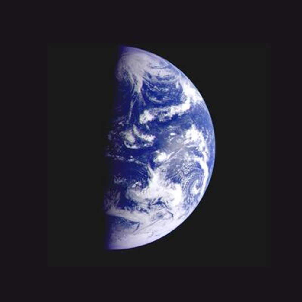
Spherical Earth (Cartography 🗺️)
Spherical Earth or Earth's curvature refers to the approximation of the figure of the Earth as a sphere. The earliest documented mention of the concept dates from around the 5th century BC, when it appears in the writings of Greek philosophers. In the 3rd […]
Spherical Earth or Earth's curvature refers to the approximation of the figure of the Earth as a sphere. The earliest documented mention of the concept dates from around the 5th century BC, when it appears in the writings of Greek philosophers. In the 3rd […]
Original post on mastodon.social
mastodon.social
December 22, 2025 at 7:15 AM
Spherical Earth (Cartography 🗺️)
Spherical Earth or Earth's curvature refers to the approximation of the figure of the Earth as a sphere. The earliest documented mention of the concept dates from around the 5th century BC, when it appears in the writings of Greek philosophers. In the 3rd […]
Spherical Earth or Earth's curvature refers to the approximation of the figure of the Earth as a sphere. The earliest documented mention of the concept dates from around the 5th century BC, when it appears in the writings of Greek philosophers. In the 3rd […]
Ekman spiral (Oceanography 🌊)
Ekman transport is part of Ekman motion theory, first investigated in 1902 by Vagn Walfrid Ekman. Winds are the main source of energy for ocean circulation, and Ekman transport is a component of wind-driven ocean current. Ekman transport occurs when ocean surface […]
Ekman transport is part of Ekman motion theory, first investigated in 1902 by Vagn Walfrid Ekman. Winds are the main source of energy for ocean circulation, and Ekman transport is a component of wind-driven ocean current. Ekman transport occurs when ocean surface […]
Original post on mastodon.social
mastodon.social
December 21, 2025 at 7:01 PM
Ekman spiral (Oceanography 🌊)
Ekman transport is part of Ekman motion theory, first investigated in 1902 by Vagn Walfrid Ekman. Winds are the main source of energy for ocean circulation, and Ekman transport is a component of wind-driven ocean current. Ekman transport occurs when ocean surface […]
Ekman transport is part of Ekman motion theory, first investigated in 1902 by Vagn Walfrid Ekman. Winds are the main source of energy for ocean circulation, and Ekman transport is a component of wind-driven ocean current. Ekman transport occurs when ocean surface […]
List of karst areas in Estonia (Karst 🌍)
This is the list of karst areas located in Estonia. The list is incomplete.
https://en.wikipedia.org/wiki/List_of_karst_areas_in_Estonia
#listofkarstareasinestonia #karst
This is the list of karst areas located in Estonia. The list is incomplete.
https://en.wikipedia.org/wiki/List_of_karst_areas_in_Estonia
#listofkarstareasinestonia #karst

List of karst areas in Estonia - Wikipedia
en.wikipedia.org
December 21, 2025 at 7:10 AM
List of karst areas in Estonia (Karst 🌍)
This is the list of karst areas located in Estonia. The list is incomplete.
https://en.wikipedia.org/wiki/List_of_karst_areas_in_Estonia
#listofkarstareasinestonia #karst
This is the list of karst areas located in Estonia. The list is incomplete.
https://en.wikipedia.org/wiki/List_of_karst_areas_in_Estonia
#listofkarstareasinestonia #karst
Necromeny (Parasitology 🧬)
Necromeny is a symbiotic relationship where an animal infects a host and waits inside its body until its death, at which point it develops and completes its life-cycle on the cadaver, feeding on the decaying matter and the subsequent bacterial growth. As the […]
Necromeny is a symbiotic relationship where an animal infects a host and waits inside its body until its death, at which point it develops and completes its life-cycle on the cadaver, feeding on the decaying matter and the subsequent bacterial growth. As the […]
Original post on mastodon.social
mastodon.social
December 20, 2025 at 7:04 PM
Necromeny (Parasitology 🧬)
Necromeny is a symbiotic relationship where an animal infects a host and waits inside its body until its death, at which point it develops and completes its life-cycle on the cadaver, feeding on the decaying matter and the subsequent bacterial growth. As the […]
Necromeny is a symbiotic relationship where an animal infects a host and waits inside its body until its death, at which point it develops and completes its life-cycle on the cadaver, feeding on the decaying matter and the subsequent bacterial growth. As the […]
Desert riparian (Biomes 🌍)
Desert riparian is a North American desert vegetation type occurring in the bottoms of valleys, canyons, and other watercourses that have water at or near the surface most of the year. The visual character is of large, lush, perennial green trees surrounded by dry […]
Desert riparian is a North American desert vegetation type occurring in the bottoms of valleys, canyons, and other watercourses that have water at or near the surface most of the year. The visual character is of large, lush, perennial green trees surrounded by dry […]
Original post on mastodon.social
mastodon.social
December 20, 2025 at 7:09 AM
Desert riparian (Biomes 🌍)
Desert riparian is a North American desert vegetation type occurring in the bottoms of valleys, canyons, and other watercourses that have water at or near the surface most of the year. The visual character is of large, lush, perennial green trees surrounded by dry […]
Desert riparian is a North American desert vegetation type occurring in the bottoms of valleys, canyons, and other watercourses that have water at or near the surface most of the year. The visual character is of large, lush, perennial green trees surrounded by dry […]
National Biodiversity Centre (Singapore) (Biodiversity 🦗)
The National Biodiversity Centre is a branch of the National Parks Board and serves as Singapore's one-stop centre for biodiversity-related information and activities. It manages all available information and data on biodiversity in […]
The National Biodiversity Centre is a branch of the National Parks Board and serves as Singapore's one-stop centre for biodiversity-related information and activities. It manages all available information and data on biodiversity in […]
Original post on mastodon.social
mastodon.social
December 19, 2025 at 7:09 PM
National Biodiversity Centre (Singapore) (Biodiversity 🦗)
The National Biodiversity Centre is a branch of the National Parks Board and serves as Singapore's one-stop centre for biodiversity-related information and activities. It manages all available information and data on biodiversity in […]
The National Biodiversity Centre is a branch of the National Parks Board and serves as Singapore's one-stop centre for biodiversity-related information and activities. It manages all available information and data on biodiversity in […]
Jordan's rule (Ecogeographic rules 🌍)
Jordan's rule is an ecogeographical rule that describes the inverse relationship between water temperature and meristic characteristics in various species of fish. The most commonly observed relationship is that fin ray, vertebrae, or scale numbers increase […]
Jordan's rule is an ecogeographical rule that describes the inverse relationship between water temperature and meristic characteristics in various species of fish. The most commonly observed relationship is that fin ray, vertebrae, or scale numbers increase […]
Original post on mastodon.social
mastodon.social
December 19, 2025 at 7:13 AM
Jordan's rule (Ecogeographic rules 🌍)
Jordan's rule is an ecogeographical rule that describes the inverse relationship between water temperature and meristic characteristics in various species of fish. The most commonly observed relationship is that fin ray, vertebrae, or scale numbers increase […]
Jordan's rule is an ecogeographical rule that describes the inverse relationship between water temperature and meristic characteristics in various species of fish. The most commonly observed relationship is that fin ray, vertebrae, or scale numbers increase […]
Forest floor (Biogeochemical cycle 🔄)
The forest floor, also called detritus or duff, is the part of a forest ecosystem that mediates between the living, aboveground portion of the forest and the mineral soil, principally composed of dead and decaying plant matter such as rotting wood and shed […]
The forest floor, also called detritus or duff, is the part of a forest ecosystem that mediates between the living, aboveground portion of the forest and the mineral soil, principally composed of dead and decaying plant matter such as rotting wood and shed […]
Original post on mastodon.social
mastodon.social
December 18, 2025 at 7:13 PM
Forest floor (Biogeochemical cycle 🔄)
The forest floor, also called detritus or duff, is the part of a forest ecosystem that mediates between the living, aboveground portion of the forest and the mineral soil, principally composed of dead and decaying plant matter such as rotting wood and shed […]
The forest floor, also called detritus or duff, is the part of a forest ecosystem that mediates between the living, aboveground portion of the forest and the mineral soil, principally composed of dead and decaying plant matter such as rotting wood and shed […]
Desert pavement (Deserts 🏜️)
A desert pavement, also called reg, serir, gibber, or saï is a desert surface covered with closely packed, interlocking angular or rounded rock fragments of pebble and cobble size. They typically top alluvial fans. Desert varnish collects on the exposed surface […]
A desert pavement, also called reg, serir, gibber, or saï is a desert surface covered with closely packed, interlocking angular or rounded rock fragments of pebble and cobble size. They typically top alluvial fans. Desert varnish collects on the exposed surface […]
Original post on mastodon.social
mastodon.social
December 18, 2025 at 7:13 AM
Desert pavement (Deserts 🏜️)
A desert pavement, also called reg, serir, gibber, or saï is a desert surface covered with closely packed, interlocking angular or rounded rock fragments of pebble and cobble size. They typically top alluvial fans. Desert varnish collects on the exposed surface […]
A desert pavement, also called reg, serir, gibber, or saï is a desert surface covered with closely packed, interlocking angular or rounded rock fragments of pebble and cobble size. They typically top alluvial fans. Desert varnish collects on the exposed surface […]
Karst (Karst 🌍)
Karst is a topography formed from the dissolution of soluble carbonate rocks such as limestone and dolomite. It is characterized by features like poljes above and drainage systems with sinkholes and caves underground. There is some evidence that karst may occur in more […]
Karst is a topography formed from the dissolution of soluble carbonate rocks such as limestone and dolomite. It is characterized by features like poljes above and drainage systems with sinkholes and caves underground. There is some evidence that karst may occur in more […]
Original post on mastodon.social
mastodon.social
December 17, 2025 at 7:11 PM
Karst (Karst 🌍)
Karst is a topography formed from the dissolution of soluble carbonate rocks such as limestone and dolomite. It is characterized by features like poljes above and drainage systems with sinkholes and caves underground. There is some evidence that karst may occur in more […]
Karst is a topography formed from the dissolution of soluble carbonate rocks such as limestone and dolomite. It is characterized by features like poljes above and drainage systems with sinkholes and caves underground. There is some evidence that karst may occur in more […]
Bar (river morphology) (Hydrology 💧)
A bar in a river is an elevated region of sediment that has been deposited by the flow. Types of bars include mid-channel bars, point bars, and mouth bars. The locations of bars are determined by the geometry of the river and the flow through it. Bars […]
A bar in a river is an elevated region of sediment that has been deposited by the flow. Types of bars include mid-channel bars, point bars, and mouth bars. The locations of bars are determined by the geometry of the river and the flow through it. Bars […]
Original post on mastodon.social
mastodon.social
December 17, 2025 at 7:14 AM
Bar (river morphology) (Hydrology 💧)
A bar in a river is an elevated region of sediment that has been deposited by the flow. Types of bars include mid-channel bars, point bars, and mouth bars. The locations of bars are determined by the geometry of the river and the flow through it. Bars […]
A bar in a river is an elevated region of sediment that has been deposited by the flow. Types of bars include mid-channel bars, point bars, and mouth bars. The locations of bars are determined by the geometry of the river and the flow through it. Bars […]
Remote sensing (oceanography) (Oceanography 🌊)
Remote sensing in oceanography is a widely used observational technique which enables researchers to acquire data of a location without physically measuring at that location. Remote sensing in oceanography mostly refers to measuring properties of […]
Remote sensing in oceanography is a widely used observational technique which enables researchers to acquire data of a location without physically measuring at that location. Remote sensing in oceanography mostly refers to measuring properties of […]
Original post on mastodon.social
mastodon.social
December 16, 2025 at 7:12 PM
Remote sensing (oceanography) (Oceanography 🌊)
Remote sensing in oceanography is a widely used observational technique which enables researchers to acquire data of a location without physically measuring at that location. Remote sensing in oceanography mostly refers to measuring properties of […]
Remote sensing in oceanography is a widely used observational technique which enables researchers to acquire data of a location without physically measuring at that location. Remote sensing in oceanography mostly refers to measuring properties of […]
Thicket (Habitat 🌄)
A thicket is a very dense stand of trees or tall shrubs, often dominated by only one or a few species, to the exclusion of all others. They may be formed by species that shed large numbers of highly viable seeds that are able to germinate in the shelter of the maternal […]
A thicket is a very dense stand of trees or tall shrubs, often dominated by only one or a few species, to the exclusion of all others. They may be formed by species that shed large numbers of highly viable seeds that are able to germinate in the shelter of the maternal […]
Original post on mastodon.social
mastodon.social
December 16, 2025 at 7:15 AM
Thicket (Habitat 🌄)
A thicket is a very dense stand of trees or tall shrubs, often dominated by only one or a few species, to the exclusion of all others. They may be formed by species that shed large numbers of highly viable seeds that are able to germinate in the shelter of the maternal […]
A thicket is a very dense stand of trees or tall shrubs, often dominated by only one or a few species, to the exclusion of all others. They may be formed by species that shed large numbers of highly viable seeds that are able to germinate in the shelter of the maternal […]
Taxon (Organisms 🐞)
In biology, a taxon is a group of one or more populations of an organism, or organisms, as seen by taxonomists to form a biological unit;. Although neither is required, a taxon, once its description has become established, is usually known by a particular name and is given a […]
In biology, a taxon is a group of one or more populations of an organism, or organisms, as seen by taxonomists to form a biological unit;. Although neither is required, a taxon, once its description has become established, is usually known by a particular name and is given a […]
Original post on mastodon.social
mastodon.social
December 15, 2025 at 7:17 PM
Taxon (Organisms 🐞)
In biology, a taxon is a group of one or more populations of an organism, or organisms, as seen by taxonomists to form a biological unit;. Although neither is required, a taxon, once its description has become established, is usually known by a particular name and is given a […]
In biology, a taxon is a group of one or more populations of an organism, or organisms, as seen by taxonomists to form a biological unit;. Although neither is required, a taxon, once its description has become established, is usually known by a particular name and is given a […]
Cretaceous (Geological periods 🌍)
The Cretaceous is a geologic period that lasted from about 143.1 to 66 Ma. It is the third and final period of the Mesozoic Era, as well as the longest. At around 77.1 million years, it is the ninth and longest geological period of the entire Phanerozoic. The […]
The Cretaceous is a geologic period that lasted from about 143.1 to 66 Ma. It is the third and final period of the Mesozoic Era, as well as the longest. At around 77.1 million years, it is the ninth and longest geological period of the entire Phanerozoic. The […]
Original post on mastodon.social
mastodon.social
December 15, 2025 at 7:23 AM
Cretaceous (Geological periods 🌍)
The Cretaceous is a geologic period that lasted from about 143.1 to 66 Ma. It is the third and final period of the Mesozoic Era, as well as the longest. At around 77.1 million years, it is the ninth and longest geological period of the entire Phanerozoic. The […]
The Cretaceous is a geologic period that lasted from about 143.1 to 66 Ma. It is the third and final period of the Mesozoic Era, as well as the longest. At around 77.1 million years, it is the ninth and longest geological period of the entire Phanerozoic. The […]
Central Highlands (Madagascar) (Biogeography 🌍)
The Central Highlands, Central High Plateau, or Hautes-Terres are a mountainous biogeographical region in central Madagascar. They include the contiguous part of the island's interior above 800 m elevation. The Central Highlands are separated from […]
The Central Highlands, Central High Plateau, or Hautes-Terres are a mountainous biogeographical region in central Madagascar. They include the contiguous part of the island's interior above 800 m elevation. The Central Highlands are separated from […]
Original post on mastodon.social
mastodon.social
December 14, 2025 at 7:13 PM
Central Highlands (Madagascar) (Biogeography 🌍)
The Central Highlands, Central High Plateau, or Hautes-Terres are a mountainous biogeographical region in central Madagascar. They include the contiguous part of the island's interior above 800 m elevation. The Central Highlands are separated from […]
The Central Highlands, Central High Plateau, or Hautes-Terres are a mountainous biogeographical region in central Madagascar. They include the contiguous part of the island's interior above 800 m elevation. The Central Highlands are separated from […]