


Phil Stooke
@philstooke.mastodon.social.ap.brid.gy
Professor Emeritus, University of Western Ontario. Space exploration and planetary cartography, historical and present. A longtime poster on […]
🌉 bridged from ⁂ https://mastodon.social/@PhilStooke, follow @ap.brid.gy to interact
🌉 bridged from ⁂ https://mastodon.social/@PhilStooke, follow @ap.brid.gy to interact
The next mission to launch to Venus was NASA's Pioneer Venus mission, with two components. Here is a NASA look back on its 4oth anniversary:
https://www.nasa.gov/centers-and-facilities/ames/40-years-ago-pioneers-encounter-venus/
The mission consisted of an […]
[Original post on mastodon.social]
https://www.nasa.gov/centers-and-facilities/ames/40-years-ago-pioneers-encounter-venus/
The mission consisted of an […]
[Original post on mastodon.social]

November 26, 2025 at 7:38 AM
The next mission to launch to Venus was NASA's Pioneer Venus mission, with two components. Here is a NASA look back on its 4oth anniversary:
https://www.nasa.gov/centers-and-facilities/ames/40-years-ago-pioneers-encounter-venus/
The mission consisted of an […]
[Original post on mastodon.social]
https://www.nasa.gov/centers-and-facilities/ames/40-years-ago-pioneers-encounter-venus/
The mission consisted of an […]
[Original post on mastodon.social]
This all looks very nice, but we still don't know much about what is being seen. Take the very bright area Maxwell at the top - is it a mountain range or a canyon like Juventae Chasma on Mars? We only know it's rough. (Now we know it's a mountain) What about the dark smooth area with a bright […]
Original post on mastodon.social
mastodon.social
November 25, 2025 at 8:06 AM
This all looks very nice, but we still don't know much about what is being seen. Take the very bright area Maxwell at the top - is it a mountain range or a canyon like Juventae Chasma on Mars? We only know it's rough. (Now we know it's a mountain) What about the dark smooth area with a bright […]
Around the time of Veneras 9 and 10, Earth-based radar mapping was improving. This map is a composite of two radar datasets from this period, reprojected to the azimuthal projection I always use for global maps.
One paper was this:
Campbell, D.B. and Burns […]
[Original post on mastodon.social]
One paper was this:
Campbell, D.B. and Burns […]
[Original post on mastodon.social]

November 25, 2025 at 7:59 AM
Around the time of Veneras 9 and 10, Earth-based radar mapping was improving. This map is a composite of two radar datasets from this period, reprojected to the azimuthal projection I always use for global maps.
One paper was this:
Campbell, D.B. and Burns […]
[Original post on mastodon.social]
One paper was this:
Campbell, D.B. and Burns […]
[Original post on mastodon.social]
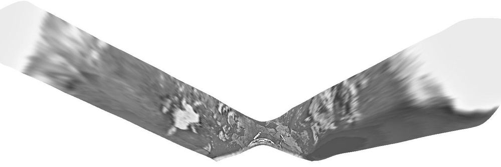
Here is a rather crudely reprojected version of the Venera 10 panorama. Once again we don't know the orientation of this map. The lander ended up on a patch of flat rocky slabs, and there seem to be similar rocky areas on each horizon, left and right. Between […]
[Original post on mastodon.social]
[Original post on mastodon.social]
November 24, 2025 at 7:46 AM
Here is a rather crudely reprojected version of the Venera 10 panorama. Once again we don't know the orientation of this map. The lander ended up on a patch of flat rocky slabs, and there seem to be similar rocky areas on each horizon, left and right. Between […]
[Original post on mastodon.social]
[Original post on mastodon.social]
My pal and occasional co-author Ted Stryk made them - with good intentions, to help people get some idea of what Venus looks like on the surface, because the Russian panorama format is harder to understand. I'm not sure it is really a good idea to do this just because people can get the wrong […]
Original post on mastodon.social
mastodon.social
November 23, 2025 at 7:44 AM
My pal and occasional co-author Ted Stryk made them - with good intentions, to help people get some idea of what Venus looks like on the surface, because the Russian panorama format is harder to understand. I'm not sure it is really a good idea to do this just because people can get the wrong […]
We have seen the Venera 9 and 10 panoramas, but take a look at this from the Planetary Society:
https://www.planetary.org/space-images/rectified-vs-original-venera-9-and-10-panoramas
(presented without any explanation on that page). This version has more detail […]
https://www.planetary.org/space-images/rectified-vs-original-venera-9-and-10-panoramas
(presented without any explanation on that page). This version has more detail […]
Original post on mastodon.social
mastodon.social
November 23, 2025 at 7:37 AM
We have seen the Venera 9 and 10 panoramas, but take a look at this from the Planetary Society:
https://www.planetary.org/space-images/rectified-vs-original-venera-9-and-10-panoramas
(presented without any explanation on that page). This version has more detail […]
https://www.planetary.org/space-images/rectified-vs-original-venera-9-and-10-panoramas
(presented without any explanation on that page). This version has more detail […]
Here is an old Soviet version of the Venera 10 image, a bit too contrasty so details get lost especially at the horizon. But what we see is different from Venera 9's boulders. This is a nearly flat area with platy slabs of rock interspersed with darker […]
[Original post on mastodon.social]
[Original post on mastodon.social]

November 22, 2025 at 7:40 AM
Here is an old Soviet version of the Venera 10 image, a bit too contrasty so details get lost especially at the horizon. But what we see is different from Venera 9's boulders. This is a nearly flat area with platy slabs of rock interspersed with darker […]
[Original post on mastodon.social]
[Original post on mastodon.social]
OK, what did Venera 10 see? This is the link I gave earlier to Don Mitchell's page about Venus images:
http://mentallandscape.com/C_CatalogVenus.htm
and here is the raw Venera 10 image:
http://mentallandscape.com/C_Venera10.jpg
His expert processing gives us this […]
http://mentallandscape.com/C_CatalogVenus.htm
and here is the raw Venera 10 image:
http://mentallandscape.com/C_Venera10.jpg
His expert processing gives us this […]
Original post on mastodon.social
mastodon.social
November 22, 2025 at 7:29 AM
OK, what did Venera 10 see? This is the link I gave earlier to Don Mitchell's page about Venus images:
http://mentallandscape.com/C_CatalogVenus.htm
and here is the raw Venera 10 image:
http://mentallandscape.com/C_Venera10.jpg
His expert processing gives us this […]
http://mentallandscape.com/C_CatalogVenus.htm
and here is the raw Venera 10 image:
http://mentallandscape.com/C_Venera10.jpg
His expert processing gives us this […]
If Venera 10 landed in the hills, I might expect a landscape similar to that at Venera 9's site, lots of blocks where the rock has been broken by dense patterns of faults. But it didn't see that. Tomorrow we will see what the second image of the surface of Venus revealed.
#venus #venera10
#venus #venera10
November 21, 2025 at 7:34 AM
The south part of the map contains a large volcanic shield (Samodiva Mons) which has released lava flows showing up as brighter lobate markings extending north and east from the shield. The 300 km circle is the landing location - it could be anywhere in there. The closeup, 100 km wide, shows the […]
Original post on mastodon.social
mastodon.social
November 21, 2025 at 7:30 AM
The south part of the map contains a large volcanic shield (Samodiva Mons) which has released lava flows showing up as brighter lobate markings extending north and east from the shield. The 300 km circle is the landing location - it could be anywhere in there. The closeup, 100 km wide, shows the […]
Venera 10 landed in the area shown here at two scales - at left a map spanning 500 km shows major landforms, at right, full Magellan resolution gives us details of part of the landing ellipse. We see mixed geology - the dark areas are smooth (ish) plains […]
[Original post on mastodon.social]
[Original post on mastodon.social]

November 21, 2025 at 7:24 AM
Venera 10 landed in the area shown here at two scales - at left a map spanning 500 km shows major landforms, at right, full Magellan resolution gives us details of part of the landing ellipse. We see mixed geology - the dark areas are smooth (ish) plains […]
[Original post on mastodon.social]
[Original post on mastodon.social]
Venera 10 launched 6 days after V9 (14 June '75) and landed 3 days after its sibling (25 October). This map shows the area. Like Venera 9 it was east of Beta Regio, but 1500 km further south. As with all landers so far the target was essentially unknown, only […]
[Original post on mastodon.social]
[Original post on mastodon.social]

November 20, 2025 at 7:17 AM
Venera 10 launched 6 days after V9 (14 June '75) and landed 3 days after its sibling (25 October). This map shows the area. Like Venera 9 it was east of Beta Regio, but 1500 km further south. As with all landers so far the target was essentially unknown, only […]
[Original post on mastodon.social]
[Original post on mastodon.social]
... but when Magellan images became available they attracted more attention […]
Original post on mastodon.social
mastodon.social
November 19, 2025 at 7:28 AM
... but when Magellan images became available they attracted more attention […]
When we looked at Soviet lunar missions I showed the Luna 22 bistatic radar image of part of the Moon. It didn't tell us much we didn't know about the Moon (rocky surfaces and slopes facing the radar will reflect it on to the detector). But a year later Venera 9 used bistatic radar to study […]
Original post on mastodon.social
mastodon.social
November 19, 2025 at 7:20 AM
When we looked at Soviet lunar missions I showed the Luna 22 bistatic radar image of part of the Moon. It didn't tell us much we didn't know about the Moon (rocky surfaces and slopes facing the radar will reflect it on to the detector). But a year later Venera 9 used bistatic radar to study […]
Here's that map with its crudely separated section. But what's this? Why have I rotated it? As far as I can tell there is absolutely no information about the orientation of the map, so here it is in an arbitrary orientation. I suppose a whole-sky image might […]
[Original post on mastodon.social]
[Original post on mastodon.social]

November 18, 2025 at 7:43 AM
Here's that map with its crudely separated section. But what's this? Why have I rotated it? As far as I can tell there is absolutely no information about the orientation of the map, so here it is in an arbitrary orientation. I suppose a whole-sky image might […]
[Original post on mastodon.social]
[Original post on mastodon.social]
A small point and a big one about yesterday's map made from the Venera 9 panorama. First, at the left end we see a more distant hillside (or possibly two) beyond a near horizon (or perhaps two). I should have separated the bit beyond the closest horizon to suggest an intervening valley - I'll […]
Original post on mastodon.social
mastodon.social
November 18, 2025 at 7:35 AM
A small point and a big one about yesterday's map made from the Venera 9 panorama. First, at the left end we see a more distant hillside (or possibly two) beyond a near horizon (or perhaps two). I should have separated the bit beyond the closest horizon to suggest an intervening valley - I'll […]
I wanted to be able to map the Venera landing sites. We should be able to project the panoramas to a map geometry. I'm not clever enough to figure it out, but veteran space artist Don Davis published drawn maps for Veneras 9 and 10, so I had a start. He […]
[Original post on mastodon.social]
[Original post on mastodon.social]

November 17, 2025 at 8:08 AM
I wanted to be able to map the Venera landing sites. We should be able to project the panoramas to a map geometry. I'm not clever enough to figure it out, but veteran space artist Don Davis published drawn maps for Veneras 9 and 10, so I had a start. He […]
[Original post on mastodon.social]
[Original post on mastodon.social]
I want to make a map of this Venera 9 site. To start, here is a Soviet-era version of the panorama. I do want to emphasize what an incredible advance this was - the first image of the landscape of another planet, taken in October 1975, before the Viking […]
[Original post on mastodon.social]
[Original post on mastodon.social]

November 17, 2025 at 8:04 AM
I want to make a map of this Venera 9 site. To start, here is a Soviet-era version of the panorama. I do want to emphasize what an incredible advance this was - the first image of the landscape of another planet, taken in October 1975, before the Viking […]
[Original post on mastodon.social]
[Original post on mastodon.social]
We are probably looking across a valley at a slope on the other side, and right in the corner is a glimpse of a triangle of light. It's darker than the sky on the right - is it another hillside farther away? We see so little of it and the image is so damaged in that area that we don't really […]
Original post on mastodon.social
mastodon.social
November 16, 2025 at 8:16 AM
We are probably looking across a valley at a slope on the other side, and right in the corner is a glimpse of a triangle of light. It's darker than the sky on the right - is it another hillside farther away? We see so little of it and the image is so damaged in that area that we don't really […]
First impressions: it's very rocky, a landscape of broken chunks of rock, some of them looking rounded (maybe by sandblasting as surface winds blow sediment around). Some look like they may be made of 2 or more layers. Between them is a gravelly surface. At right the horizon has rocks seen in […]
Original post on mastodon.social
mastodon.social
November 16, 2025 at 8:14 AM
First impressions: it's very rocky, a landscape of broken chunks of rock, some of them looking rounded (maybe by sandblasting as surface winds blow sediment around). Some look like they may be made of 2 or more layers. Between them is a gravelly surface. At right the horizon has rocks seen in […]
This view on Don Mitchell's page shows how the original pan has many gaps (during which other telemetry was transmitted), how some of them can be patched from the second pan, and finally how the remaining gaps can be patched by interpolating. That's to make it look good, it doesn't add any new […]
Original post on mastodon.social
mastodon.social
November 16, 2025 at 8:05 AM
This view on Don Mitchell's page shows how the original pan has many gaps (during which other telemetry was transmitted), how some of them can be patched from the second pan, and finally how the remaining gaps can be patched by interpolating. That's to make it look good, it doesn't add any new […]
The link I posted earlier shows the Venera 9 panorama - here is the image in its raw form:
http://mentallandscape.com/C_Venera09.jpg
Don Mitchell explains how it was taken. A scanner runs from left to right across the scene, looking out at the horizon at left and right but down at the […]
http://mentallandscape.com/C_Venera09.jpg
Don Mitchell explains how it was taken. A scanner runs from left to right across the scene, looking out at the horizon at left and right but down at the […]
Original post on mastodon.social
mastodon.social
November 16, 2025 at 7:56 AM
The link I posted earlier shows the Venera 9 panorama - here is the image in its raw form:
http://mentallandscape.com/C_Venera09.jpg
Don Mitchell explains how it was taken. A scanner runs from left to right across the scene, looking out at the horizon at left and right but down at the […]
http://mentallandscape.com/C_Venera09.jpg
Don Mitchell explains how it was taken. A scanner runs from left to right across the scene, looking out at the horizon at left and right but down at the […]
If fractured cut the lava channel they are younger than the channel. It's hard to tell where the lava came from, probably one of the set of north-south fractures west of the channel. The 'chasma' is a broad rift valley. The image in this post shows the site […]
[Original post on mastodon.social]
[Original post on mastodon.social]

November 15, 2025 at 7:40 AM
If fractured cut the lava channel they are younger than the channel. It's hard to tell where the lava came from, probably one of the set of north-south fractures west of the channel. The 'chasma' is a broad rift valley. The image in this post shows the site […]
[Original post on mastodon.social]
[Original post on mastodon.social]
I missed a day so I will do two maps today. We are zooming in on the Venera 9 landing site. Yesterday it looked rough. This map shows a very fractured surface, cracks large and small all over the image. There were some gaps in radar coverage which I filled in […]
[Original post on mastodon.social]
[Original post on mastodon.social]

November 15, 2025 at 7:29 AM
I missed a day so I will do two maps today. We are zooming in on the Venera 9 landing site. Yesterday it looked rough. This map shows a very fractured surface, cracks large and small all over the image. There were some gaps in radar coverage which I filled in […]
[Original post on mastodon.social]
[Original post on mastodon.social]