


Philippe Rufin
@philrufin.bsky.social
Geographer interested in 🛰️ EarthObservation for 🌿agriculture, 💧water resources, and 🌍 sustainable land management.
F.R.S. FNRS Postdoctoral Fellow 🇪🇺
Earth & Life Institute - UCLouvain 🇧🇪
Earth Observation Lab - HUBerlin 🇩🇪
F.R.S. FNRS Postdoctoral Fellow 🇪🇺
Earth & Life Institute - UCLouvain 🇧🇪
Earth Observation Lab - HUBerlin 🇩🇪
Despite free access to petabytes of satellite data, cloud computing platforms, and a wealth of high-performing computer vision models, satellite-based field delineation simply doesn´t work in landscapes dominated by smallholders (fragmented, heterogeneous, and dynamic)!

July 17, 2025 at 10:25 AM
Despite free access to petabytes of satellite data, cloud computing platforms, and a wealth of high-performing computer vision models, satellite-based field delineation simply doesn´t work in landscapes dominated by smallholders (fragmented, heterogeneous, and dynamic)!
🌍 🛰️ 🌱 🌽👨🏿🌾🛖💻⚙️
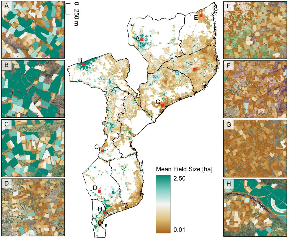
Preprint on national-scale satellite-based crop field delineation in smallholder landscapes is out:
doi.org/10.48550/arX...
🌍 🛰️ 🌱 🌽👨🏿🌾🛖💻⚙️
Preprint on national-scale satellite-based crop field delineation in smallholder landscapes is out:
doi.org/10.48550/arX...
🌍 🛰️ 🌱 🌽👨🏿🌾🛖💻⚙️
July 17, 2025 at 10:25 AM
🌍 🛰️ 🌱 🌽👨🏿🌾🛖💻⚙️
Preprint on national-scale satellite-based crop field delineation in smallholder landscapes is out:
doi.org/10.48550/arX...
🌍 🛰️ 🌱 🌽👨🏿🌾🛖💻⚙️
Preprint on national-scale satellite-based crop field delineation in smallholder landscapes is out:
doi.org/10.48550/arX...
🌍 🛰️ 🌱 🌽👨🏿🌾🛖💻⚙️
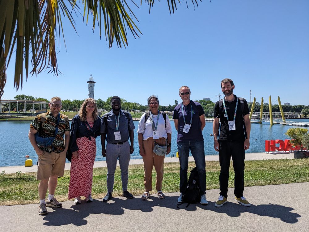
Great in-person meeting of the entire SEN4MOZ @eoafrica-rd.org project team at #LPS25! @humboldteolab.bsky.social
June 25, 2025 at 3:08 PM
Great in-person meeting of the entire SEN4MOZ @eoafrica-rd.org project team at #LPS25! @humboldteolab.bsky.social
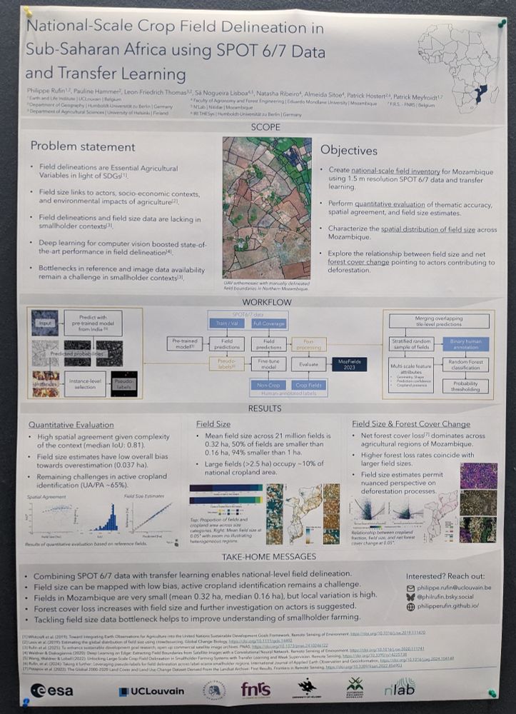
#LPS25 poster alert: National scale field delineation in #Mozambique using 1.5m SPOT data, mapping field size & linking to #deforestation. Come by @ Hall X5, Poster S18.
June 25, 2025 at 9:23 AM
#LPS25 poster alert: National scale field delineation in #Mozambique using 1.5m SPOT data, mapping field size & linking to #deforestation. Come by @ Hall X5, Poster S18.
New #IEEE GRSM paper on responsible #AI for #EarthObservation! AI for EO data analysis holds great promise in addressing global challenges but simultaneously needs a careful examination of the dimensions of responsibility. We reviewed them in this #openaccess article: doi.org/10.1109/MGRS...

March 3, 2025 at 8:01 PM
New #IEEE GRSM paper on responsible #AI for #EarthObservation! AI for EO data analysis holds great promise in addressing global challenges but simultaneously needs a careful examination of the dimensions of responsibility. We reviewed them in this #openaccess article: doi.org/10.1109/MGRS...
Commercial very-high-resolution satellite imagery is crucial for monitoring smallholder farming systems (SDG 2), but paywalls block innovation and progress.
We call for open access to these data for sustainability-centered research in @pnas.org!
Read the full text here: doi.org/10.1073/pnas...
We call for open access to these data for sustainability-centered research in @pnas.org!
Read the full text here: doi.org/10.1073/pnas...

February 12, 2025 at 10:11 PM
Commercial very-high-resolution satellite imagery is crucial for monitoring smallholder farming systems (SDG 2), but paywalls block innovation and progress.
We call for open access to these data for sustainability-centered research in @pnas.org!
Read the full text here: doi.org/10.1073/pnas...
We call for open access to these data for sustainability-centered research in @pnas.org!
Read the full text here: doi.org/10.1073/pnas...
Return of the good times: the Earth Observation Lab of @humboldtuni.bsky.social has joined Bluesky: Follow @humboldteolab.bsky.social for all things terrestrial remote sensing and geospatial at large!

February 12, 2025 at 3:52 PM
Return of the good times: the Earth Observation Lab of @humboldtuni.bsky.social has joined Bluesky: Follow @humboldteolab.bsky.social for all things terrestrial remote sensing and geospatial at large!
Review paper condensing 163 papers on mapping smallholder agriculture in West Africa shows breakdown of first-author affiliations and funding sources - both more than 50% Europe & North America: doi.org/10.3390/land...

January 24, 2025 at 9:51 PM
Review paper condensing 163 papers on mapping smallholder agriculture in West Africa shows breakdown of first-author affiliations and funding sources - both more than 50% Europe & North America: doi.org/10.3390/land...
I´m compiling (high-impact) papers using #remotesensing data products for causal inference in a wrong way, e.g., by not properly accounting for class semantics, non-random error structures, temporal inconsistencies, methods updates, all of it. Please share or DM! #EOchat

January 8, 2025 at 2:29 PM
I´m compiling (high-impact) papers using #remotesensing data products for causal inference in a wrong way, e.g., by not properly accounting for class semantics, non-random error structures, temporal inconsistencies, methods updates, all of it. Please share or DM! #EOchat
Lyndon Estes et al. presents a region-wide, multi-year (2017-2023) set of #EarthObservation crop field boundary labels for #Africa: arxiv.org/pdf/2412.18483
Data containing 30k+ fields collected from @planetlabs.bsky.social NICFI data available here: zenodo.org/records/1106...
Data containing 30k+ fields collected from @planetlabs.bsky.social NICFI data available here: zenodo.org/records/1106...

January 6, 2025 at 2:00 PM
Lyndon Estes et al. presents a region-wide, multi-year (2017-2023) set of #EarthObservation crop field boundary labels for #Africa: arxiv.org/pdf/2412.18483
Data containing 30k+ fields collected from @planetlabs.bsky.social NICFI data available here: zenodo.org/records/1106...
Data containing 30k+ fields collected from @planetlabs.bsky.social NICFI data available here: zenodo.org/records/1106...
Nearly all #EarthObservation-based #cropland maps across #SubSaharanAfrica include fallows in their cropland definition:
🛰️mapped cropland ≠ actively used cropland🌽
We used @Climateforest #PlanetScopenetScope#timeseriesmeseries to map active cropland and short fallows 👇
🛰️mapped cropland ≠ actively used cropland🌽
We used @Climateforest #PlanetScopenetScope#timeseriesmeseries to map active cropland and short fallows 👇

January 3, 2025 at 12:59 PM
Nearly all #EarthObservation-based #cropland maps across #SubSaharanAfrica include fallows in their cropland definition:
🛰️mapped cropland ≠ actively used cropland🌽
We used @Climateforest #PlanetScopenetScope#timeseriesmeseries to map active cropland and short fallows 👇
🛰️mapped cropland ≠ actively used cropland🌽
We used @Climateforest #PlanetScopenetScope#timeseriesmeseries to map active cropland and short fallows 👇


Ever heard the term machambas? If not, read this short piece and get some impressions of #smallholder #agriculture in #Mozambique: https://erc-midland.earth/2022/05/23/machambas/

January 3, 2025 at 12:59 PM
Ever heard the term machambas? If not, read this short piece and get some impressions of #smallholder #agriculture in #Mozambique: https://erc-midland.earth/2022/05/23/machambas/
#LPS22 day 1 poster session: does image texture relate to field size (<5ha) in #smallholder systems? Come and find an answer at poster board 144, close to the drinks!

January 3, 2025 at 12:59 PM
#LPS22 day 1 poster session: does image texture relate to field size (<5ha) in #smallholder systems? Come and find an answer at poster board 144, close to the drinks!
Check out our new @EarthArXiv pre-print on using @climateforest NICFI´s @planet mosaics for large-area#landcoverr#mappingg in tropical#smallholderr systems: https://doi.org/10.31223/X5P62Fð�§µ

January 3, 2025 at 12:59 PM
Check out our new @EarthArXiv pre-print on using @climateforest NICFI´s @planet mosaics for large-area#landcoverr#mappingg in tropical#smallholderr systems: https://doi.org/10.31223/X5P62Fð�§µ
Latest @landusescience paper using #Landsat time series for mapping dry season cropping in largest #irrigation scheme of #Turkey now fully #openaccess: https://doi.org/10.1080/1747423X.2020.1858198

January 3, 2025 at 12:58 PM
Latest @landusescience paper using #Landsat time series for mapping dry season cropping in largest #irrigation scheme of #Turkey now fully #openaccess: https://doi.org/10.1080/1747423X.2020.1858198
Teaching #earthobservation to @HumboldtUni
´s#geographyy students is fun again, despite online-only classrooms. Check out the new online#teachingg materials for#BScc &#MScc#remotesensingg#seminarss:
http://hu.berlin/geo_rs | http://hu.berlin/gcg_eo
´s#geographyy students is fun again, despite online-only classrooms. Check out the new online#teachingg materials for#BScc &#MScc#remotesensingg#seminarss:
http://hu.berlin/geo_rs | http://hu.berlin/gcg_eo

January 3, 2025 at 12:58 PM
Teaching #earthobservation to @HumboldtUni
´s#geographyy students is fun again, despite online-only classrooms. Check out the new online#teachingg materials for#BScc &#MScc#remotesensingg#seminarss:
http://hu.berlin/geo_rs | http://hu.berlin/gcg_eo
´s#geographyy students is fun again, despite online-only classrooms. Check out the new online#teachingg materials for#BScc &#MScc#remotesensingg#seminarss:
http://hu.berlin/geo_rs | http://hu.berlin/gcg_eo
Teaching #EarthObservation online this term. Includes optical #remotesensing of land surfaces using #Rstats & @qgis, much of it #Landsat #timeseries analysis. Weekly assignments here: http://eo.hu-geomatics.de/ Feedback welcome!

January 3, 2025 at 12:58 PM
Teaching #EarthObservation online this term. Includes optical #remotesensing of land surfaces using #Rstats & @qgis, much of it #Landsat #timeseries analysis. Weekly assignments here: http://eo.hu-geomatics.de/ Feedback welcome!
#LPS19 finale: @d__frantz' #FORCE_EO tools enabled my #PhD paper on #mapping of #agricultural sytems of Turkey!

January 3, 2025 at 12:58 PM
#LPS19 finale: @d__frantz' #FORCE_EO tools enabled my #PhD paper on #mapping of #agricultural sytems of Turkey!
Complex landscapes profit from 10m res: check how we use land surface #phenology from #Sentinel2 for mapping #tree cover on #olive groves! #LPS19 poster zone A, panel 18!

January 3, 2025 at 12:58 PM
Complex landscapes profit from 10m res: check how we use land surface #phenology from #Sentinel2 for mapping #tree cover on #olive groves! #LPS19 poster zone A, panel 18!
Great presentation of our work on #land surface #phenology mapping enabled by #Landsat #timeseries! 2M square km of #phenometrics shown @ #LPS19 #savannah session by @MarcelSchwieder!

January 3, 2025 at 12:58 PM
Great presentation of our work on #land surface #phenology mapping enabled by #Landsat #timeseries! 2M square km of #phenometrics shown @ #LPS19 #savannah session by @MarcelSchwieder!
Use the #FORCE_EO for #Landsat & #Sentinel2 processing - learn more on friday afternoon! Talk by @d__frantz in the #LPS19 #ARD session, 3:15 @ Amber!

January 3, 2025 at 12:58 PM
Use the #FORCE_EO for #Landsat & #Sentinel2 processing - learn more on friday afternoon! Talk by @d__frantz in the #LPS19 #ARD session, 3:15 @ Amber!
Cool to see new #remotesensing datasets: VENµS data for#cropp type mapping presented in#LPS199#phenologyy session by @USDA's F. Gao!

January 3, 2025 at 12:58 PM
Cool to see new #remotesensing datasets: VENµS data for#cropp type mapping presented in#LPS199#phenologyy session by @USDA's F. Gao!