


Pete Macharia, PhD
@pete-m-m.bsky.social
GIS | Geospatial health | Spatial epidemiology |
| Based @itmantwerp.bsky.social | Funded by @fwovlaanderen.bsky.social | Visiting Scientist @ KEMRI-Wellcome Trust Research Programme | https://www.petermacharia.com/
| Based @itmantwerp.bsky.social | Funded by @fwovlaanderen.bsky.social | Visiting Scientist @ KEMRI-Wellcome Trust Research Programme | https://www.petermacharia.com/
Big data in modelling #geographical accessibility to healthcare: a scoping review protocol
Big data is transforming how we understand #spatial access to services (closer-to-reality estimates). We are cataloguing these
bmjopen.bmj.com/content/15/1...
@itmantwerp.bsky.social
#GISChat #GeoHealth
Big data is transforming how we understand #spatial access to services (closer-to-reality estimates). We are cataloguing these
bmjopen.bmj.com/content/15/1...
@itmantwerp.bsky.social
#GISChat #GeoHealth
Big data in modelling geographical accessibility to healthcare: a scoping review protocol
Introduction Research on modelling geographical accessibility to healthcare services has witnessed rapid methodological advancement and refinement. One of the contributing factors is the increasing av...
bmjopen.bmj.com
October 22, 2025 at 9:24 AM
Big data in modelling #geographical accessibility to healthcare: a scoping review protocol
Big data is transforming how we understand #spatial access to services (closer-to-reality estimates). We are cataloguing these
bmjopen.bmj.com/content/15/1...
@itmantwerp.bsky.social
#GISChat #GeoHealth
Big data is transforming how we understand #spatial access to services (closer-to-reality estimates). We are cataloguing these
bmjopen.bmj.com/content/15/1...
@itmantwerp.bsky.social
#GISChat #GeoHealth
Not all cities are the same: different tales of maternal health indicators in 62 SSA conurbations (pre-print)
Coverage indicators on utilisation, content & continuity of care for maternal & newborn care
A typology of performance
www.researchsquare.com/article/rs-7...
@itmantwerp.bsky.social
Coverage indicators on utilisation, content & continuity of care for maternal & newborn care
A typology of performance
www.researchsquare.com/article/rs-7...
@itmantwerp.bsky.social
Not all cities are the same: different tales of maternal health indicators in 62 sub-Saharan African conurbations
Background: Sub-Saharan Africa (SSA) accounts for the majority of global maternal and perinatal deaths. Maternal healthcare service provision in SSA cities is not commensurate with the region's fastes...
www.researchsquare.com
October 15, 2025 at 8:42 AM
Not all cities are the same: different tales of maternal health indicators in 62 SSA conurbations (pre-print)
Coverage indicators on utilisation, content & continuity of care for maternal & newborn care
A typology of performance
www.researchsquare.com/article/rs-7...
@itmantwerp.bsky.social
Coverage indicators on utilisation, content & continuity of care for maternal & newborn care
A typology of performance
www.researchsquare.com/article/rs-7...
@itmantwerp.bsky.social
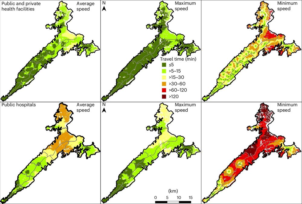
Modelling geographical accessibility & inequalities to childbirth services in the Grand Nokoué Metropolitan Area, Benin
Access varied by wealth, urbanicity, & travel speed
@itmantwerp.bsky.social
Read our new paper: link.springer.com/article/10.1...
#gischat #geospatial #GeoHealth #HealthEquity
Access varied by wealth, urbanicity, & travel speed
@itmantwerp.bsky.social
Read our new paper: link.springer.com/article/10.1...
#gischat #geospatial #GeoHealth #HealthEquity

September 10, 2025 at 6:29 AM
Modelling geographical accessibility & inequalities to childbirth services in the Grand Nokoué Metropolitan Area, Benin
Access varied by wealth, urbanicity, & travel speed
@itmantwerp.bsky.social
Read our new paper: link.springer.com/article/10.1...
#gischat #geospatial #GeoHealth #HealthEquity
Access varied by wealth, urbanicity, & travel speed
@itmantwerp.bsky.social
Read our new paper: link.springer.com/article/10.1...
#gischat #geospatial #GeoHealth #HealthEquity
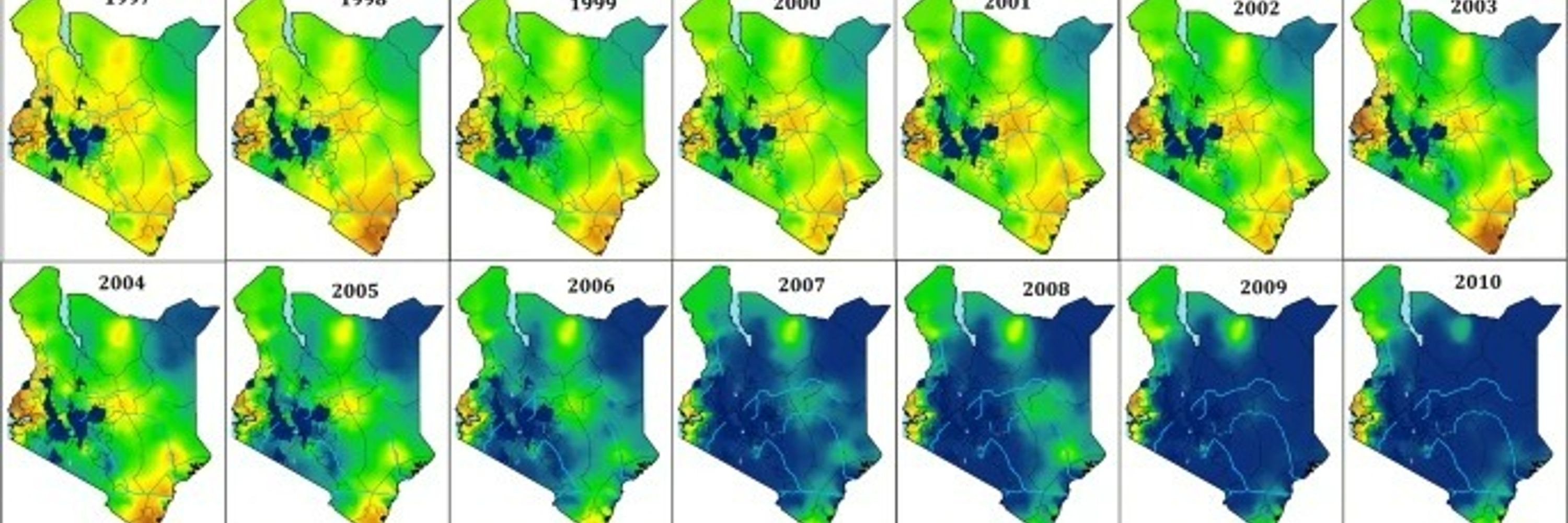
How far is your closest hospital or clinic? Public health researchers explain why Africa needs up-to-date health facility databases.
See our recent article in @africa.theconversation.com
theconversation.com/how-far-is-y...
See our recent article in @africa.theconversation.com
theconversation.com/how-far-is-y...

How far is your closest hospital or clinic? Public health researchers explain why Africa needs up-to-date health facility databases
Health lists support informed decision-making to enhance the delivery of services at various levels.
theconversation.com
July 2, 2025 at 4:09 PM
How far is your closest hospital or clinic? Public health researchers explain why Africa needs up-to-date health facility databases.
See our recent article in @africa.theconversation.com
theconversation.com/how-far-is-y...
See our recent article in @africa.theconversation.com
theconversation.com/how-far-is-y...
Published: 𝐏𝐚𝐞𝐝𝐢𝐚𝐭𝐫𝐢𝐜 𝐚𝐧𝐚𝐞𝐦𝐢𝐚 𝐢𝐧 𝐫𝐮𝐫𝐚𝐥 𝐊𝐞𝐧𝐲𝐚 𝐚𝐧𝐝 𝐭𝐡𝐞 𝐫𝐨𝐥𝐞 𝐨𝐟 𝐭𝐫𝐚𝐯𝐞𝐥 𝐭𝐢𝐦𝐞 𝐭𝐨 𝐞𝐦𝐞𝐫𝐠𝐞𝐧𝐜𝐲 𝐜𝐚𝐫𝐞 𝐬𝐞𝐫𝐯𝐢𝐜𝐞𝐬, led by @halolemoses.bsky.social
Travel time associated with the severity of anaemia presentation at admission
#gischat #geospatial #GeoHealth #HealthEquity
Read more: doi.org/10.3389/fepi...
Travel time associated with the severity of anaemia presentation at admission
#gischat #geospatial #GeoHealth #HealthEquity
Read more: doi.org/10.3389/fepi...


May 16, 2025 at 10:05 AM
Published: 𝐏𝐚𝐞𝐝𝐢𝐚𝐭𝐫𝐢𝐜 𝐚𝐧𝐚𝐞𝐦𝐢𝐚 𝐢𝐧 𝐫𝐮𝐫𝐚𝐥 𝐊𝐞𝐧𝐲𝐚 𝐚𝐧𝐝 𝐭𝐡𝐞 𝐫𝐨𝐥𝐞 𝐨𝐟 𝐭𝐫𝐚𝐯𝐞𝐥 𝐭𝐢𝐦𝐞 𝐭𝐨 𝐞𝐦𝐞𝐫𝐠𝐞𝐧𝐜𝐲 𝐜𝐚𝐫𝐞 𝐬𝐞𝐫𝐯𝐢𝐜𝐞𝐬, led by @halolemoses.bsky.social
Travel time associated with the severity of anaemia presentation at admission
#gischat #geospatial #GeoHealth #HealthEquity
Read more: doi.org/10.3389/fepi...
Travel time associated with the severity of anaemia presentation at admission
#gischat #geospatial #GeoHealth #HealthEquity
Read more: doi.org/10.3389/fepi...
When health data go dark: the importance of the DHS Program and imagining its future
We discuss;
Consequences on the tracking of population health outcomes & behaviours.
Implications for national decision-makers & the global health community
Potential paths forward
doi.org/10.1186/s129...
We discuss;
Consequences on the tracking of population health outcomes & behaviours.
Implications for national decision-makers & the global health community
Potential paths forward
doi.org/10.1186/s129...
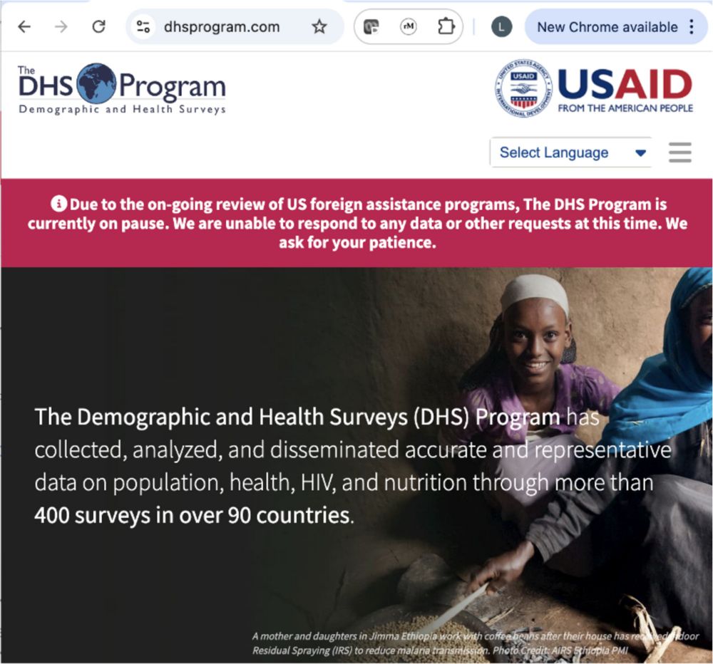
When health data go dark: the importance of the DHS Program and imagining its future - BMC Medicine
Background The suspension and/or termination of many programmes funded through the United States Agency for International Development (USAID) by the new US administration has severe short- and long-te...
doi.org
April 28, 2025 at 6:02 AM
When health data go dark: the importance of the DHS Program and imagining its future
We discuss;
Consequences on the tracking of population health outcomes & behaviours.
Implications for national decision-makers & the global health community
Potential paths forward
doi.org/10.1186/s129...
We discuss;
Consequences on the tracking of population health outcomes & behaviours.
Implications for national decision-makers & the global health community
Potential paths forward
doi.org/10.1186/s129...
Inequities in #spatial access to childbirth care in Conakry, Guinea. Published in Nature Cities
► Disparities in #geographic access to facilities providing childbirth care
► Driven by skewed spatial distribution of facilities, heavy traffic & socio-economic disadvantage
doi.org/10.1038/s442...
► Disparities in #geographic access to facilities providing childbirth care
► Driven by skewed spatial distribution of facilities, heavy traffic & socio-economic disadvantage
doi.org/10.1038/s442...
April 23, 2025 at 12:38 PM
Inequities in #spatial access to childbirth care in Conakry, Guinea. Published in Nature Cities
► Disparities in #geographic access to facilities providing childbirth care
► Driven by skewed spatial distribution of facilities, heavy traffic & socio-economic disadvantage
doi.org/10.1038/s442...
► Disparities in #geographic access to facilities providing childbirth care
► Driven by skewed spatial distribution of facilities, heavy traffic & socio-economic disadvantage
doi.org/10.1038/s442...
Fully Funded PhD Studentships in Spatial Data Science or Geographic Information Science geods.ac.uk/2025/03/19/f...
#GISchat #GeoSky #GeoHealth
#GISchat #GeoSky #GeoHealth

Fully Funded PhD Studentships in Spatial Data Science or Geographic Information Science
About the PhD studentships We invite applications for two funded PhD studentships situated on topics that sit at the intersection of geographic information science and the creation of groundbreakin…
geods.ac.uk
April 15, 2025 at 6:23 PM
Fully Funded PhD Studentships in Spatial Data Science or Geographic Information Science geods.ac.uk/2025/03/19/f...
#GISchat #GeoSky #GeoHealth
#GISchat #GeoSky #GeoHealth
Reposted by Pete Macharia, PhD

#ResearchHighlight from Peter Macharia, KWTRP
Putting health facilities on the map: a renewed call to create geolocated, comprehensive, updated, openly licensed #dataset of health facilities
Read more 👉 www.ndm.ac/tropmed.res-hi
Publication 👉 bmcmedicine.biomedcentral.com/articles/10....
Putting health facilities on the map: a renewed call to create geolocated, comprehensive, updated, openly licensed #dataset of health facilities
Read more 👉 www.ndm.ac/tropmed.res-hi
Publication 👉 bmcmedicine.biomedcentral.com/articles/10....

April 15, 2025 at 8:59 AM
#ResearchHighlight from Peter Macharia, KWTRP
Putting health facilities on the map: a renewed call to create geolocated, comprehensive, updated, openly licensed #dataset of health facilities
Read more 👉 www.ndm.ac/tropmed.res-hi
Publication 👉 bmcmedicine.biomedcentral.com/articles/10....
Putting health facilities on the map: a renewed call to create geolocated, comprehensive, updated, openly licensed #dataset of health facilities
Read more 👉 www.ndm.ac/tropmed.res-hi
Publication 👉 bmcmedicine.biomedcentral.com/articles/10....
𝗣𝘂𝘁𝘁𝗶𝗻𝗴 𝗵𝗲𝗮𝗹𝘁𝗵 𝗳𝗮𝗰𝗶𝗹𝗶𝘁𝗶𝗲𝘀 𝗼𝗻 𝘁𝗵𝗲 𝗺𝗮𝗽 𝗶𝗻 𝘀𝘂𝗯-𝗦𝗮𝗵𝗮𝗿𝗮𝗻 𝗔𝗳𝗿𝗶𝗰𝗮
A (renewed) call to create geolocated, comprehensive, updated, openly licensed dataset of health facilities in SSA.
In #BMCMedicine! bmcmedicine.biomedcentral.com/articles/10....
#GISchat #GeoSky #GeoHealth, @itmantwerp.bsky.social
A (renewed) call to create geolocated, comprehensive, updated, openly licensed dataset of health facilities in SSA.
In #BMCMedicine! bmcmedicine.biomedcentral.com/articles/10....
#GISchat #GeoSky #GeoHealth, @itmantwerp.bsky.social

Putting health facilities on the map: a renewed call to create geolocated, comprehensive, updated, openly licensed dataset of health facilities in sub-Saharan African countries - BMC Medicine
Background Healthcare service provision, planning, and management depend on the availability of a geolocated, up-to-date, comprehensive health facility database (HFDB) to adequately meet a population’...
bmcmedicine.biomedcentral.com
April 8, 2025 at 6:17 AM
𝗣𝘂𝘁𝘁𝗶𝗻𝗴 𝗵𝗲𝗮𝗹𝘁𝗵 𝗳𝗮𝗰𝗶𝗹𝗶𝘁𝗶𝗲𝘀 𝗼𝗻 𝘁𝗵𝗲 𝗺𝗮𝗽 𝗶𝗻 𝘀𝘂𝗯-𝗦𝗮𝗵𝗮𝗿𝗮𝗻 𝗔𝗳𝗿𝗶𝗰𝗮
A (renewed) call to create geolocated, comprehensive, updated, openly licensed dataset of health facilities in SSA.
In #BMCMedicine! bmcmedicine.biomedcentral.com/articles/10....
#GISchat #GeoSky #GeoHealth, @itmantwerp.bsky.social
A (renewed) call to create geolocated, comprehensive, updated, openly licensed dataset of health facilities in SSA.
In #BMCMedicine! bmcmedicine.biomedcentral.com/articles/10....
#GISchat #GeoSky #GeoHealth, @itmantwerp.bsky.social
𝗪𝗵𝗲𝗻 𝗵𝗲𝗮𝗹𝘁𝗵 𝗱𝗮𝘁𝗮 𝗴𝗼 𝗱𝗮𝗿𝗸: In this commentary, we draw attention to the consequence of suspending USAID funding to the Demographic and Health Surveys
www.itg.be/en/health-st...
@jilmolenaar.bsky.social @m-mariealice.bsky.social @alichristou.bsky.social @wongkerry.bsky.social @lenkabenova.bsky.social
www.itg.be/en/health-st...
@jilmolenaar.bsky.social @m-mariealice.bsky.social @alichristou.bsky.social @wongkerry.bsky.social @lenkabenova.bsky.social

When health data go dark
A call to restore DHS Program funding
www.itg.be
February 13, 2025 at 4:45 PM
𝗪𝗵𝗲𝗻 𝗵𝗲𝗮𝗹𝘁𝗵 𝗱𝗮𝘁𝗮 𝗴𝗼 𝗱𝗮𝗿𝗸: In this commentary, we draw attention to the consequence of suspending USAID funding to the Demographic and Health Surveys
www.itg.be/en/health-st...
@jilmolenaar.bsky.social @m-mariealice.bsky.social @alichristou.bsky.social @wongkerry.bsky.social @lenkabenova.bsky.social
www.itg.be/en/health-st...
@jilmolenaar.bsky.social @m-mariealice.bsky.social @alichristou.bsky.social @wongkerry.bsky.social @lenkabenova.bsky.social
Reposted by Pete Macharia, PhD

Hooray! Our paper (led by Emily Nightingale) is out.
Inferring the regional distribution of Visceral Leishmaniasis incidence from data at different spatial scales.
w/ @grahammedley.bsky.social and others.
www.nature.com/articles/s43...
Inferring the regional distribution of Visceral Leishmaniasis incidence from data at different spatial scales.
w/ @grahammedley.bsky.social and others.
www.nature.com/articles/s43...

November 21, 2024 at 10:58 AM
Hooray! Our paper (led by Emily Nightingale) is out.
Inferring the regional distribution of Visceral Leishmaniasis incidence from data at different spatial scales.
w/ @grahammedley.bsky.social and others.
www.nature.com/articles/s43...
Inferring the regional distribution of Visceral Leishmaniasis incidence from data at different spatial scales.
w/ @grahammedley.bsky.social and others.
www.nature.com/articles/s43...
Hi Bluesky. I am a #spatial epidemiologist: #rspatial, #geohealth, #gischat
I work on spatial health metrics for an improved understanding of maternal health disparities in urban SSA.
Eg., #geographic access, marginalisation, coverage & disease prevalence
Let's connect: www.petermacharia.com
I work on spatial health metrics for an improved understanding of maternal health disparities in urban SSA.
Eg., #geographic access, marginalisation, coverage & disease prevalence
Let's connect: www.petermacharia.com

Petermacharia | Spatial analysis | GIS | Kenya
Petermacharia has an interest in GIS, Mapping, Spatial analysis, spatial access to healthcare and disease mapping.
www.petermacharia.com
November 16, 2024 at 9:47 PM
Hi Bluesky. I am a #spatial epidemiologist: #rspatial, #geohealth, #gischat
I work on spatial health metrics for an improved understanding of maternal health disparities in urban SSA.
Eg., #geographic access, marginalisation, coverage & disease prevalence
Let's connect: www.petermacharia.com
I work on spatial health metrics for an improved understanding of maternal health disparities in urban SSA.
Eg., #geographic access, marginalisation, coverage & disease prevalence
Let's connect: www.petermacharia.com
Looking forward to the International Conference on Urban Health in Marrakesh (18-21/11/24)
◾I will present ongoing work where we monitor hourly temperature in >30 locations in Lubumbashi city
◾This includes measurement in delivery rooms & within the compound of health facilities
www.icuh2024.org
◾I will present ongoing work where we monitor hourly temperature in >30 locations in Lubumbashi city
◾This includes measurement in delivery rooms & within the compound of health facilities
www.icuh2024.org


November 15, 2024 at 8:41 AM
Looking forward to the International Conference on Urban Health in Marrakesh (18-21/11/24)
◾I will present ongoing work where we monitor hourly temperature in >30 locations in Lubumbashi city
◾This includes measurement in delivery rooms & within the compound of health facilities
www.icuh2024.org
◾I will present ongoing work where we monitor hourly temperature in >30 locations in Lubumbashi city
◾This includes measurement in delivery rooms & within the compound of health facilities
www.icuh2024.org
November 14, 2024 at 6:52 AM
"This #map represents what I know": the power of putting Lubumbashi’s #maternal healthcare services on the map
"Keeping the maps accurate therefore requires a continuous effort, which is unlikely to happen without local ownership."
www.itg.be/fr/histoires...
www.itg.be/en/health-st...
"Keeping the maps accurate therefore requires a continuous effort, which is unlikely to happen without local ownership."
www.itg.be/fr/histoires...
www.itg.be/en/health-st...

Mapping Lubumbashi’s maternal healthcare services
Recently, health system managers & stakeholders provided input on preliminary maps of maternal & newborn healthcare facilities in Lubumbashi
www.itg.be
November 12, 2024 at 6:27 AM
"This #map represents what I know": the power of putting Lubumbashi’s #maternal healthcare services on the map
"Keeping the maps accurate therefore requires a continuous effort, which is unlikely to happen without local ownership."
www.itg.be/fr/histoires...
www.itg.be/en/health-st...
"Keeping the maps accurate therefore requires a continuous effort, which is unlikely to happen without local ownership."
www.itg.be/fr/histoires...
www.itg.be/en/health-st...