


Paul P Murphy, CNN
@paulpmurphy.bsky.social
Reporter. Red Sox fan.
This Maxar false color infrared image is horrific.
The red is the vegetation that's left. The black scar in Altadena and the side of the San Gabriel Mountains, is the burn scar.
It cuts so far into Altadena.
The smoke plume is the Eaton Fire still burning.
www.cnn.com/weather/live...
The red is the vegetation that's left. The black scar in Altadena and the side of the San Gabriel Mountains, is the burn scar.
It cuts so far into Altadena.
The smoke plume is the Eaton Fire still burning.
www.cnn.com/weather/live...

January 10, 2025 at 11:01 PM
This Maxar false color infrared image is horrific.
The red is the vegetation that's left. The black scar in Altadena and the side of the San Gabriel Mountains, is the burn scar.
It cuts so far into Altadena.
The smoke plume is the Eaton Fire still burning.
www.cnn.com/weather/live...
The red is the vegetation that's left. The black scar in Altadena and the side of the San Gabriel Mountains, is the burn scar.
It cuts so far into Altadena.
The smoke plume is the Eaton Fire still burning.
www.cnn.com/weather/live...
What a different 24 hours makes.
The Eaton fire had much of Altadena, California ablaze yesterday (image 1). Today, many of the fires (in orange) that Maxar Technologies detected with their shortwave infrared sensor are out (image 2).
The Eaton fire had much of Altadena, California ablaze yesterday (image 1). Today, many of the fires (in orange) that Maxar Technologies detected with their shortwave infrared sensor are out (image 2).


January 10, 2025 at 3:40 AM
What a different 24 hours makes.
The Eaton fire had much of Altadena, California ablaze yesterday (image 1). Today, many of the fires (in orange) that Maxar Technologies detected with their shortwave infrared sensor are out (image 2).
The Eaton fire had much of Altadena, California ablaze yesterday (image 1). Today, many of the fires (in orange) that Maxar Technologies detected with their shortwave infrared sensor are out (image 2).
What's in the area where the Eaton Fire started?
- Hiking trails
- Two major power transmission lines for Southern California Edison (220kV and 66kV). CNN reached out to SCE for comment but didn't immediately get a response.
- Hiking trails
- Two major power transmission lines for Southern California Edison (220kV and 66kV). CNN reached out to SCE for comment but didn't immediately get a response.

January 9, 2025 at 8:33 PM
What's in the area where the Eaton Fire started?
- Hiking trails
- Two major power transmission lines for Southern California Edison (220kV and 66kV). CNN reached out to SCE for comment but didn't immediately get a response.
- Hiking trails
- Two major power transmission lines for Southern California Edison (220kV and 66kV). CNN reached out to SCE for comment but didn't immediately get a response.
Where did the Eaton Fire start:
- @calfire.bsky.social says 618p on Wednesday
- OroraTech data detects hotspot in Eaton Creek area @ 635p (area in red).
- @calfire.bsky.social says 618p on Wednesday
- OroraTech data detects hotspot in Eaton Creek area @ 635p (area in red).

January 9, 2025 at 8:32 PM
Where did the Eaton Fire start:
- @calfire.bsky.social says 618p on Wednesday
- OroraTech data detects hotspot in Eaton Creek area @ 635p (area in red).
- @calfire.bsky.social says 618p on Wednesday
- OroraTech data detects hotspot in Eaton Creek area @ 635p (area in red).
Where did the Palisades Fire start:
- @calfire.bsky.social says 1030a on
Tuesday
- OroraTech data detects hotspot in area east the Summit neighborhood @ 1035a
- @esa.int image @ 1037a shows large smoke plume rising from the ignition site.
- @calfire.bsky.social says 1030a on
Tuesday
- OroraTech data detects hotspot in area east the Summit neighborhood @ 1035a
- @esa.int image @ 1037a shows large smoke plume rising from the ignition site.

January 9, 2025 at 8:28 PM
Where did the Palisades Fire start:
- @calfire.bsky.social says 1030a on
Tuesday
- OroraTech data detects hotspot in area east the Summit neighborhood @ 1035a
- @esa.int image @ 1037a shows large smoke plume rising from the ignition site.
- @calfire.bsky.social says 1030a on
Tuesday
- OroraTech data detects hotspot in area east the Summit neighborhood @ 1035a
- @esa.int image @ 1037a shows large smoke plume rising from the ignition site.
This is a Maxar Technologies sat image with SWIR that shows the Palisade fire this morning at 1045a.
Anything in orange is on fire. The coast/PCH is on the bottom.
Anything in orange is on fire. The coast/PCH is on the bottom.

January 9, 2025 at 3:45 AM
This is a Maxar Technologies sat image with SWIR that shows the Palisade fire this morning at 1045a.
Anything in orange is on fire. The coast/PCH is on the bottom.
Anything in orange is on fire. The coast/PCH is on the bottom.
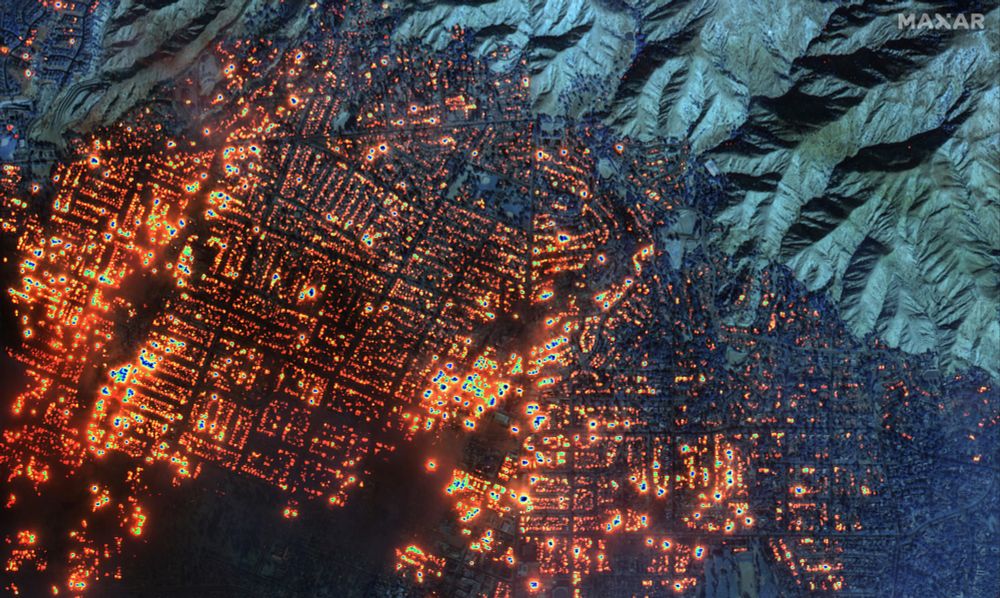
This Maxar Technologies sat image with SWIR shows what was on fire in Altadena, California this morning at 10:45 a.m. local time.
Nearly everything.
Nearly everything.
January 9, 2025 at 1:36 AM
This Maxar Technologies sat image with SWIR shows what was on fire in Altadena, California this morning at 10:45 a.m. local time.
Nearly everything.
Nearly everything.