


Paul Huttner
@paulhuttnerweather.bsky.social
MPR News chief meteorologist. Weather, guitars, and sunsets make me happy.

November 26, 2025 at 1:27 AM
Latest Monday evening 0Z HRRR continues southward trend with Tuesday storm. If verified that would increase snowfall totals forecast for MSP area by Wednesday AM. Stay tuned, snowfall forecast may "inch up" Tuesday before the snow flies.
#mnwx
#mnwx

November 25, 2025 at 1:56 AM
Latest Monday evening 0Z HRRR continues southward trend with Tuesday storm. If verified that would increase snowfall totals forecast for MSP area by Wednesday AM. Stay tuned, snowfall forecast may "inch up" Tuesday before the snow flies.
#mnwx
#mnwx
First REAL wintry storm much of MN Tue-Wed AM. ❄️
Snow NW after midnight - spreads across the north Tuesday.
Heaviest wind-driven snow w/ 40 mph+ gusts northern half of MN.
Quick burst of 1"-3" Twin Cities Tue night-Wed AM.
Windy/slick Wed AM commute MSP.
It begins...
#mnwx
Snow NW after midnight - spreads across the north Tuesday.
Heaviest wind-driven snow w/ 40 mph+ gusts northern half of MN.
Quick burst of 1"-3" Twin Cities Tue night-Wed AM.
Windy/slick Wed AM commute MSP.
It begins...
#mnwx

November 24, 2025 at 9:06 PM
First REAL wintry storm much of MN Tue-Wed AM. ❄️
Snow NW after midnight - spreads across the north Tuesday.
Heaviest wind-driven snow w/ 40 mph+ gusts northern half of MN.
Quick burst of 1"-3" Twin Cities Tue night-Wed AM.
Windy/slick Wed AM commute MSP.
It begins...
#mnwx
Snow NW after midnight - spreads across the north Tuesday.
Heaviest wind-driven snow w/ 40 mph+ gusts northern half of MN.
Quick burst of 1"-3" Twin Cities Tue night-Wed AM.
Windy/slick Wed AM commute MSP.
It begins...
#mnwx
Watching rain to windy snow scenario Tuesday into Wednesday morning. Best chance for significant accumulations north of MSP through northern half of Minnesota.
Could be gnarly travel especially north of MSP Tuesday night Wed AM.
Stay tuned...
#mnwx
Could be gnarly travel especially north of MSP Tuesday night Wed AM.
Stay tuned...
#mnwx

November 23, 2025 at 8:59 PM
Watching rain to windy snow scenario Tuesday into Wednesday morning. Best chance for significant accumulations north of MSP through northern half of Minnesota.
Could be gnarly travel especially north of MSP Tuesday night Wed AM.
Stay tuned...
#mnwx
Could be gnarly travel especially north of MSP Tuesday night Wed AM.
Stay tuned...
#mnwx
European model trending toward rain changing to accumulating snow next Tuesday.
Keeping an eye on this as we approach pre-Thanksgiving travel!
#mnwx
Keeping an eye on this as we approach pre-Thanksgiving travel!
#mnwx

November 20, 2025 at 11:49 PM
European model trending toward rain changing to accumulating snow next Tuesday.
Keeping an eye on this as we approach pre-Thanksgiving travel!
#mnwx
Keeping an eye on this as we approach pre-Thanksgiving travel!
#mnwx
And so it begins!
Slushy snow ❄️ accumulations likely overnight especially S of MSP.
NWS graphic seems reasonable given latest models.
Locally higher totals possible within the wider snow zone.
Let the games begin.
#mnwx
Slushy snow ❄️ accumulations likely overnight especially S of MSP.
NWS graphic seems reasonable given latest models.
Locally higher totals possible within the wider snow zone.
Let the games begin.
#mnwx

November 17, 2025 at 6:23 PM
And so it begins!
Slushy snow ❄️ accumulations likely overnight especially S of MSP.
NWS graphic seems reasonable given latest models.
Locally higher totals possible within the wider snow zone.
Let the games begin.
#mnwx
Slushy snow ❄️ accumulations likely overnight especially S of MSP.
NWS graphic seems reasonable given latest models.
Locally higher totals possible within the wider snow zone.
Let the games begin.
#mnwx

Just incredible.
Best aurora show I've ever seen in Minnesota.
Green, red, and pink curtains from horizon to directly overhead.
Surreal.
Seeing some amazing pictures tonight.
I captured this around 8:30 p.m. in Victoria, MN.
Hope you saw it!
#mnwx
#northernlights
Best aurora show I've ever seen in Minnesota.
Green, red, and pink curtains from horizon to directly overhead.
Surreal.
Seeing some amazing pictures tonight.
I captured this around 8:30 p.m. in Victoria, MN.
Hope you saw it!
#mnwx
#northernlights

November 12, 2025 at 3:23 AM
Just incredible.
Best aurora show I've ever seen in Minnesota.
Green, red, and pink curtains from horizon to directly overhead.
Surreal.
Seeing some amazing pictures tonight.
I captured this around 8:30 p.m. in Victoria, MN.
Hope you saw it!
#mnwx
#northernlights
Best aurora show I've ever seen in Minnesota.
Green, red, and pink curtains from horizon to directly overhead.
Surreal.
Seeing some amazing pictures tonight.
I captured this around 8:30 p.m. in Victoria, MN.
Hope you saw it!
#mnwx
#northernlights
We clipped what could be the last crop of dahlias at the Weather Lab today.
Freezing temperatures are likely the next two mornings. Coldest nights of fall so far ahead.
#mnwx
www.mprnews.org/story/2025/1...
Freezing temperatures are likely the next two mornings. Coldest nights of fall so far ahead.
#mnwx
www.mprnews.org/story/2025/1...

October 22, 2025 at 7:39 PM
We clipped what could be the last crop of dahlias at the Weather Lab today.
Freezing temperatures are likely the next two mornings. Coldest nights of fall so far ahead.
#mnwx
www.mprnews.org/story/2025/1...
Freezing temperatures are likely the next two mornings. Coldest nights of fall so far ahead.
#mnwx
www.mprnews.org/story/2025/1...
Our cool and soggy Tuesday gives way to warmer air again by Thursday into Friday. 🌧️
This is the first significant rain in more than 3 weeks for much of southern Minnesota!
#mnwx
www.mprnews.org/story/2025/1...
This is the first significant rain in more than 3 weeks for much of southern Minnesota!
#mnwx
www.mprnews.org/story/2025/1...

October 14, 2025 at 8:26 PM
Our cool and soggy Tuesday gives way to warmer air again by Thursday into Friday. 🌧️
This is the first significant rain in more than 3 weeks for much of southern Minnesota!
#mnwx
www.mprnews.org/story/2025/1...
This is the first significant rain in more than 3 weeks for much of southern Minnesota!
#mnwx
www.mprnews.org/story/2025/1...
Soggy Friday continues. 🌧️
Numerous rain showers around Minnesota now moving northward.
Garden variety lighting and thunder arcing around Mankato.
Keep the umbrella handy. ☔️
#mnwx
Numerous rain showers around Minnesota now moving northward.
Garden variety lighting and thunder arcing around Mankato.
Keep the umbrella handy. ☔️
#mnwx

September 19, 2025 at 7:35 PM
Soggy Friday continues. 🌧️
Numerous rain showers around Minnesota now moving northward.
Garden variety lighting and thunder arcing around Mankato.
Keep the umbrella handy. ☔️
#mnwx
Numerous rain showers around Minnesota now moving northward.
Garden variety lighting and thunder arcing around Mankato.
Keep the umbrella handy. ☔️
#mnwx
Warm enough for ya? 🌡️
We hit 90F today in the Twin Cities for the 12th time this year.
80s tomorrow with scattered PM thunderstorms possible from MSP westward.
#mnwx
We hit 90F today in the Twin Cities for the 12th time this year.
80s tomorrow with scattered PM thunderstorms possible from MSP westward.
#mnwx

September 16, 2025 at 7:11 PM
Warm enough for ya? 🌡️
We hit 90F today in the Twin Cities for the 12th time this year.
80s tomorrow with scattered PM thunderstorms possible from MSP westward.
#mnwx
We hit 90F today in the Twin Cities for the 12th time this year.
80s tomorrow with scattered PM thunderstorms possible from MSP westward.
#mnwx

Giant severe thunderstorm watch covers most of Minnesota 'til 4 am.
Squall line/MCS may produce 70-80 mph winds.
MSP storms likely after midnight.
Please have a shelter in mind if camping and have a way to hear warnings overnight!
#mnwx
Squall line/MCS may produce 70-80 mph winds.
MSP storms likely after midnight.
Please have a shelter in mind if camping and have a way to hear warnings overnight!
#mnwx

August 9, 2025 at 2:46 AM
Giant severe thunderstorm watch covers most of Minnesota 'til 4 am.
Squall line/MCS may produce 70-80 mph winds.
MSP storms likely after midnight.
Please have a shelter in mind if camping and have a way to hear warnings overnight!
#mnwx
Squall line/MCS may produce 70-80 mph winds.
MSP storms likely after midnight.
Please have a shelter in mind if camping and have a way to hear warnings overnight!
#mnwx
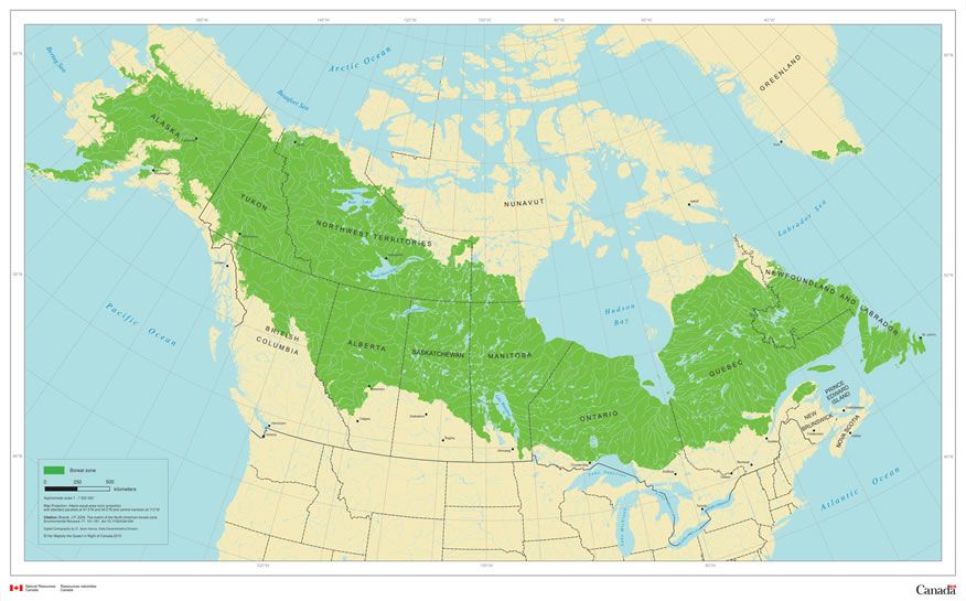
We'll have some less smoky summers, but get used to smokier MN summer trend until we reduce GHG emissions.
Canada has 1.2 BILLION ACRES of boreal forests.
Hotter drier climate sucks more moisture from dry fuels.
Unfortunately this is the tip of the iceberg for smoke potential.
Canada has 1.2 BILLION ACRES of boreal forests.
Hotter drier climate sucks more moisture from dry fuels.
Unfortunately this is the tip of the iceberg for smoke potential.
August 4, 2025 at 8:53 PM
We'll have some less smoky summers, but get used to smokier MN summer trend until we reduce GHG emissions.
Canada has 1.2 BILLION ACRES of boreal forests.
Hotter drier climate sucks more moisture from dry fuels.
Unfortunately this is the tip of the iceberg for smoke potential.
Canada has 1.2 BILLION ACRES of boreal forests.
Hotter drier climate sucks more moisture from dry fuels.
Unfortunately this is the tip of the iceberg for smoke potential.
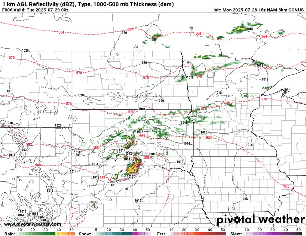
Severe risk update: ⚡️
Still high uncertainty when/where storms will blow.
Latest models trending later & further south.
Possible bow after 10 PM south of MSP along I-90?
Still a (lesser?) risk for MSP.
We'll keep watching.
Latest NAM 3k model(19Z) below 7 PM to 2 AM.
#mnwx
Still high uncertainty when/where storms will blow.
Latest models trending later & further south.
Possible bow after 10 PM south of MSP along I-90?
Still a (lesser?) risk for MSP.
We'll keep watching.
Latest NAM 3k model(19Z) below 7 PM to 2 AM.
#mnwx
July 28, 2025 at 8:29 PM
Severe risk update: ⚡️
Still high uncertainty when/where storms will blow.
Latest models trending later & further south.
Possible bow after 10 PM south of MSP along I-90?
Still a (lesser?) risk for MSP.
We'll keep watching.
Latest NAM 3k model(19Z) below 7 PM to 2 AM.
#mnwx
Still high uncertainty when/where storms will blow.
Latest models trending later & further south.
Possible bow after 10 PM south of MSP along I-90?
Still a (lesser?) risk for MSP.
We'll keep watching.
Latest NAM 3k model(19Z) below 7 PM to 2 AM.
#mnwx
Watched pot where T-Storms will fire this afternoon.
Lead cloud wave now in W MN? Or in Dakotas later?
Tons of instability/severe risk.
Where/when development occurs determines timing and coverage for tonight!
Best chance SW MN, but MSP risk 7 p.m. to midnight?
Stay tuned.
#mnwx
Lead cloud wave now in W MN? Or in Dakotas later?
Tons of instability/severe risk.
Where/when development occurs determines timing and coverage for tonight!
Best chance SW MN, but MSP risk 7 p.m. to midnight?
Stay tuned.
#mnwx

July 28, 2025 at 7:34 PM
Watched pot where T-Storms will fire this afternoon.
Lead cloud wave now in W MN? Or in Dakotas later?
Tons of instability/severe risk.
Where/when development occurs determines timing and coverage for tonight!
Best chance SW MN, but MSP risk 7 p.m. to midnight?
Stay tuned.
#mnwx
Lead cloud wave now in W MN? Or in Dakotas later?
Tons of instability/severe risk.
Where/when development occurs determines timing and coverage for tonight!
Best chance SW MN, but MSP risk 7 p.m. to midnight?
Stay tuned.
#mnwx
Fun times this Sunday night.
Should we do it again tomorrow?
NOAA HRRR shows a possible bow echo/derecho racing across Minnesota Monday evening. Loop below 5-9 PM Monday.
Ugh.
#mnwx
Should we do it again tomorrow?
NOAA HRRR shows a possible bow echo/derecho racing across Minnesota Monday evening. Loop below 5-9 PM Monday.
Ugh.
#mnwx

July 28, 2025 at 2:33 AM
Fun times this Sunday night.
Should we do it again tomorrow?
NOAA HRRR shows a possible bow echo/derecho racing across Minnesota Monday evening. Loop below 5-9 PM Monday.
Ugh.
#mnwx
Should we do it again tomorrow?
NOAA HRRR shows a possible bow echo/derecho racing across Minnesota Monday evening. Loop below 5-9 PM Monday.
Ugh.
#mnwx

Heads up SW Twin Cities.
Intense tropical deluge amongst the heaviest rainfall I've ever seen.
Dumped 1" rain in about 15 minutes here in SW Twin Cities.
Serious flash flood potential if this line stalls over MSP tonight.
#mnwx
Intense tropical deluge amongst the heaviest rainfall I've ever seen.
Dumped 1" rain in about 15 minutes here in SW Twin Cities.
Serious flash flood potential if this line stalls over MSP tonight.
#mnwx

July 23, 2025 at 4:38 AM
Heads up SW Twin Cities.
Intense tropical deluge amongst the heaviest rainfall I've ever seen.
Dumped 1" rain in about 15 minutes here in SW Twin Cities.
Serious flash flood potential if this line stalls over MSP tonight.
#mnwx
Intense tropical deluge amongst the heaviest rainfall I've ever seen.
Dumped 1" rain in about 15 minutes here in SW Twin Cities.
Serious flash flood potential if this line stalls over MSP tonight.
#mnwx

July 15, 2025 at 10:48 PM
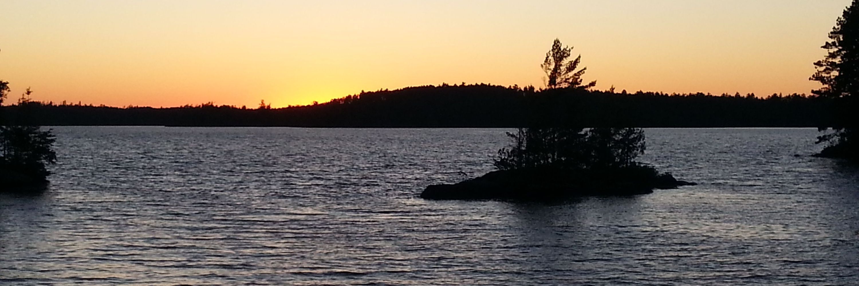
Classic Minnesota.
Surf's up on Lake Superior near Grand Marais today.
Blue water, refreshing air, and sunshine.
Cabin life at its finest.
#mnwx
Surf's up on Lake Superior near Grand Marais today.
Blue water, refreshing air, and sunshine.
Cabin life at its finest.
#mnwx
June 22, 2025 at 8:53 PM
Classic Minnesota.
Surf's up on Lake Superior near Grand Marais today.
Blue water, refreshing air, and sunshine.
Cabin life at its finest.
#mnwx
Surf's up on Lake Superior near Grand Marais today.
Blue water, refreshing air, and sunshine.
Cabin life at its finest.
#mnwx
