


OTUS Project
@otusproject.bsky.social
The Observations of Tornadoes by UAV Systems (OTUS) project is an effort to gather reliable measurements of the environment within and surrounding a tornado. www.theotusproject.com
Our world-first night vision tornado drone intercept of the Fort Ransom, ND EF2 on June 20. Watch the *FULL* video at this link: youtu.be/g_6qMXHlsqw
August 16, 2025 at 1:41 AM
Our world-first night vision tornado drone intercept of the Fort Ransom, ND EF2 on June 20. Watch the *FULL* video at this link: youtu.be/g_6qMXHlsqw
Looking inside the powerful Spiritwood, ND wedge tornado near peak size and strength. This was our second flight into it on June 20. Watch the *FULL* video at this link: youtu.be/akQbDX-MMlo
August 4, 2025 at 11:43 PM
Looking inside the powerful Spiritwood, ND wedge tornado near peak size and strength. This was our second flight into it on June 20. Watch the *FULL* video at this link: youtu.be/akQbDX-MMlo
Narrowly missed getting a drone inside this tornado south of Johnstown/Ainsworth, NE yesterday evening. We will be on the hunt for the next few days. Photo taken by team member @tornadostudy.bsky.social
July 19, 2025 at 4:27 PM
Narrowly missed getting a drone inside this tornado south of Johnstown/Ainsworth, NE yesterday evening. We will be on the hunt for the next few days. Photo taken by team member @tornadostudy.bsky.social
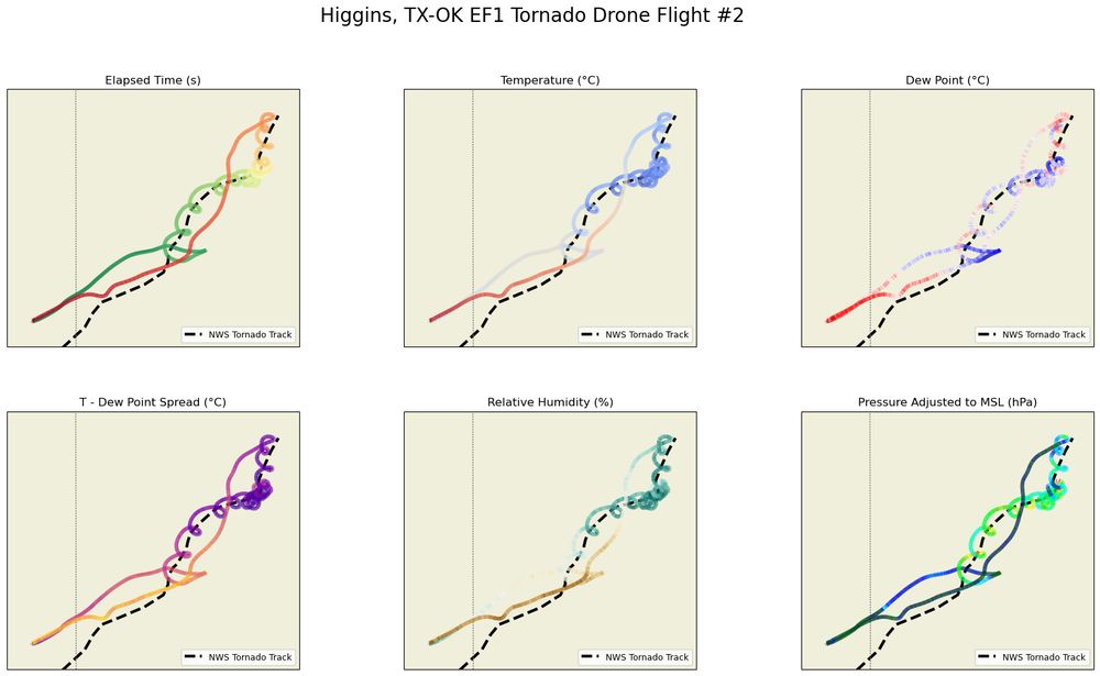
A peek at preliminary tornado data we are still processing. These traces are from one of the drones circling in the anticyclonic Higgins, TX-OK EF1 on May 18. The validation and quality control process takes time, but more data will be shared as we progress.
July 2, 2025 at 7:32 PM
A peek at preliminary tornado data we are still processing. These traces are from one of the drones circling in the anticyclonic Higgins, TX-OK EF1 on May 18. The validation and quality control process takes time, but more data will be shared as we progress.
Part 1 of our Spiritwood tornado flights, inside the tornadogenesis and growth of this monster. Watch the *FULL* video at this link: youtu.be/b9IicWFL0VQ
June 25, 2025 at 7:52 PM
Part 1 of our Spiritwood tornado flights, inside the tornadogenesis and growth of this monster. Watch the *FULL* video at this link: youtu.be/b9IicWFL0VQ
A comparison of our non-night vision perspective:
June 22, 2025 at 9:02 PM
A comparison of our non-night vision perspective:
World's first night vision drone intercept of a tornado near Fort Ransom, ND Friday night:
June 22, 2025 at 8:58 PM
World's first night vision drone intercept of a tornado near Fort Ransom, ND Friday night:
Inside the EF3+ Spiritwood, ND wedge tornado near peak intensity from our research drone!
June 22, 2025 at 4:11 PM
Inside the EF3+ Spiritwood, ND wedge tornado near peak intensity from our research drone!
Our first flight yesterday was inside the tornadogenesis and growth phase of a soon-to-be wedge tornado near Spiritwood and Jamestown, ND. Data and more video will be shared as we process material.
June 22, 2025 at 3:12 AM
Our first flight yesterday was inside the tornadogenesis and growth phase of a soon-to-be wedge tornado near Spiritwood and Jamestown, ND. Data and more video will be shared as we process material.
🚨HELP NEEDED 🚨
One of the two drones flown through this tornado has not yet been recovered. It holds immensely valuable data. We are exploring all avenues to locate it. Please let us know if you find this drone or can assist. Last known position at 46°56'28.0"N, 98°25'56.3"W
One of the two drones flown through this tornado has not yet been recovered. It holds immensely valuable data. We are exploring all avenues to locate it. Please let us know if you find this drone or can assist. Last known position at 46°56'28.0"N, 98°25'56.3"W

June 22, 2025 at 12:00 AM
🚨HELP NEEDED 🚨
One of the two drones flown through this tornado has not yet been recovered. It holds immensely valuable data. We are exploring all avenues to locate it. Please let us know if you find this drone or can assist. Last known position at 46°56'28.0"N, 98°25'56.3"W
One of the two drones flown through this tornado has not yet been recovered. It holds immensely valuable data. We are exploring all avenues to locate it. Please let us know if you find this drone or can assist. Last known position at 46°56'28.0"N, 98°25'56.3"W
Night drone view about to pass through a tornado near Fort Ransom, ND this evening collecting thermodynamic and wind data

June 21, 2025 at 4:56 AM
Night drone view about to pass through a tornado near Fort Ransom, ND this evening collecting thermodynamic and wind data
Inside the entire tornadogenesis of the mile-wide Morton, TX, EF2 tornado. Watch the *FULL* video here: youtu.be/OaNBkp1xWfg
June 14, 2025 at 2:26 AM
Inside the entire tornadogenesis of the mile-wide Morton, TX, EF2 tornado. Watch the *FULL* video here: youtu.be/OaNBkp1xWfg
Our view deploying on a tornado at Spearman TX, which became slightly too far to reach while repositioning away from hail.

June 7, 2025 at 4:13 AM
Our view deploying on a tornado at Spearman TX, which became slightly too far to reach while repositioning away from hail.
Our research drone collected data through tornadogenesis near Morton, TX yesterday, including this subvortex early in its life.
June 6, 2025 at 8:58 PM
Our research drone collected data through tornadogenesis near Morton, TX yesterday, including this subvortex early in its life.
We deployed on two tornadoes today, including one of our longest lasting flights to date inside of this massive dusty tornado near Morton, TX.

June 6, 2025 at 5:09 AM
We deployed on two tornadoes today, including one of our longest lasting flights to date inside of this massive dusty tornado near Morton, TX.
Inside of an EF1-rated tornado and severe thunderstorm winds near Willard, CO on May 23. Watch the full video here: youtu.be/nRc38pZ0E5s
May 29, 2025 at 2:34 AM
Inside of an EF1-rated tornado and severe thunderstorm winds near Willard, CO on May 23. Watch the full video here: youtu.be/nRc38pZ0E5s
A birds-eye view from our research drone of a tornado as it struck the town of Crowder, MO on May 16th. Watch the full video here: youtu.be/P3KC8TtBros
May 26, 2025 at 11:47 PM
A birds-eye view from our research drone of a tornado as it struck the town of Crowder, MO on May 16th. Watch the full video here: youtu.be/P3KC8TtBros
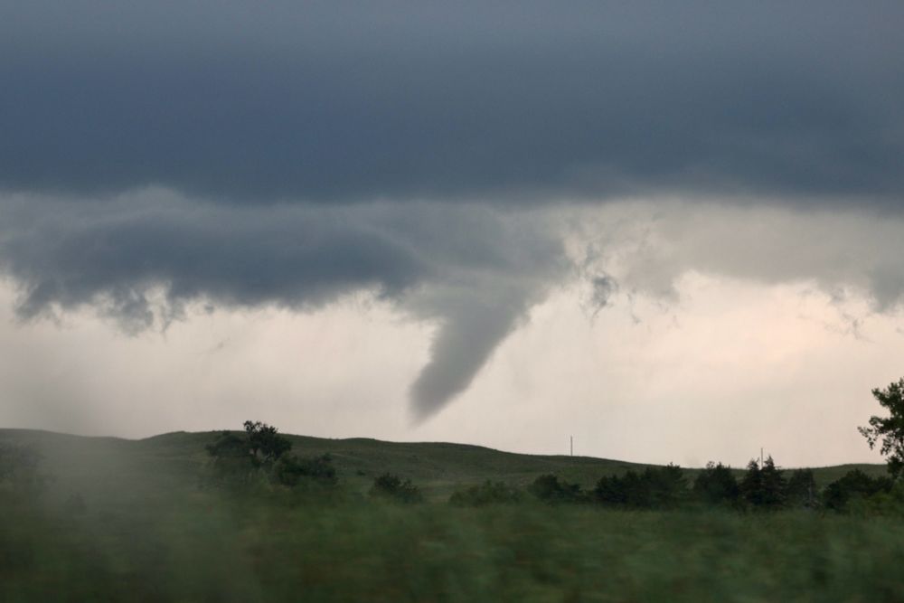
An extraordinary perspective of an anticyclonic tornado near Higgins, TX by our research drone on May 18th. Watch the full video here: youtu.be/MjEX51Qmz3o
May 23, 2025 at 7:35 PM
An extraordinary perspective of an anticyclonic tornado near Higgins, TX by our research drone on May 18th. Watch the full video here: youtu.be/MjEX51Qmz3o
Never seen before perspective of a tornado in Arnett, OK by our research drone on May 18th. Watch the full video here on YouTube: youtu.be/NGD2e741Riw
May 20, 2025 at 3:23 PM
Never seen before perspective of a tornado in Arnett, OK by our research drone on May 18th. Watch the full video here on YouTube: youtu.be/NGD2e741Riw
The eye of the Arnett, OK tornado, captured by one of our UAVs as it collected scientific data on the environment within.
May 19, 2025 at 12:52 AM
The eye of the Arnett, OK tornado, captured by one of our UAVs as it collected scientific data on the environment within.
An incredible look inside a tornado from our research drone of structures being destroyed in Crowder, Missouri
May 17, 2025 at 3:00 AM
An incredible look inside a tornado from our research drone of structures being destroyed in Crowder, Missouri
Watched tornado strike Crowder from inside UAV interceptors, 2 drones inside this tornado at once as buildings were blown apart collecting thermodynamic and wind data.


May 16, 2025 at 9:49 PM
Watched tornado strike Crowder from inside UAV interceptors, 2 drones inside this tornado at once as buildings were blown apart collecting thermodynamic and wind data.
Final preparations are wrapping up! From May 14, we will operate for several weeks collecting thermodynamic and wind data in tornadoes, and support NSF ICECHIP hail research. Our 4/27 chase was a final pre-test for data collection, flying on this tornado near Hyannis, NE:
May 11, 2025 at 1:19 AM
Final preparations are wrapping up! From May 14, we will operate for several weeks collecting thermodynamic and wind data in tornadoes, and support NSF ICECHIP hail research. Our 4/27 chase was a final pre-test for data collection, flying on this tornado near Hyannis, NE:
OTUS deployed multiple times on a tornado family yesterday evening through central Nebraska. Out again today looking for more intercepts. Pictured is the drone heading to a tornado north of Hyannis, NE. #newx

April 28, 2025 at 4:21 PM
OTUS deployed multiple times on a tornado family yesterday evening through central Nebraska. Out again today looking for more intercepts. Pictured is the drone heading to a tornado north of Hyannis, NE. #newx
The OTUS Project is preparing for tornado deployments on a volatile storm system that will move through the Plains and Midwest Sunday, Monday, and Tuesday.

April 25, 2025 at 4:43 PM
The OTUS Project is preparing for tornado deployments on a volatile storm system that will move through the Plains and Midwest Sunday, Monday, and Tuesday.