

David Olefeldt
@olefeldt.bsky.social
Professor in Catchment and Wetland Sciences at University of Alberta. Research on impacts of disturbances on function of northern peatlands, with focus on carbon cycling, greenhouse gas emissions, and on downstream water quality.
agupubs.onlinelibrary.wiley.com/doi/10.1029/...
The link in the first post doesn't seem to work yet, this should do it!
The link in the first post doesn't seem to work yet, this should do it!

Large Carbon Losses From Burned Permafrost Peatlands During Post‐Fire Succession
Burned permafrost peatlands lost ∼130 g C m−2 yr−1 during the first four years post-fire Burned landscapes returned to a net carbon dioxide sink ∼15 years post-fire Net ecosystem exchange carbon...
agupubs.onlinelibrary.wiley.com
October 7, 2025 at 9:47 PM
agupubs.onlinelibrary.wiley.com/doi/10.1029/...
The link in the first post doesn't seem to work yet, this should do it!
The link in the first post doesn't seem to work yet, this should do it!
The study was done on a peat plateau which burned in 2019. Christopher and our group managed to get together instrumentation and all in a few months to start measurements. Video below shows the site when we first arrived only a few weeks after the fire.
www.youtube.com/watch?v=REGX...
www.youtube.com/watch?v=REGX...

Steen River Burned Peatland site 2019
YouTube video by David Olefeldt
www.youtube.com
October 7, 2025 at 8:23 PM
The study was done on a peat plateau which burned in 2019. Christopher and our group managed to get together instrumentation and all in a few months to start measurements. Video below shows the site when we first arrived only a few weeks after the fire.
www.youtube.com/watch?v=REGX...
www.youtube.com/watch?v=REGX...
Our analysis also reveals where effort should be placed to further improve estimates of boreal-Arctic wetland and lake methane emissions, including wintertime methane studies from wetlands, studies of lake methane ebullition, and further refined land cover maps.


August 28, 2025 at 4:05 PM
Our analysis also reveals where effort should be placed to further improve estimates of boreal-Arctic wetland and lake methane emissions, including wintertime methane studies from wetlands, studies of lake methane ebullition, and further refined land cover maps.
Our estimate of current-day methane emissions is ~20-40% lower than many prior studies, partly because of a bias where prior studies were more likely to target sites with relatively higher emissions. Having new land cover maps with different wetland and lake types reduces this bias.

August 28, 2025 at 4:05 PM
Our estimate of current-day methane emissions is ~20-40% lower than many prior studies, partly because of a bias where prior studies were more likely to target sites with relatively higher emissions. Having new land cover maps with different wetland and lake types reduces this bias.
This study uses data from almost 200 studies going back to the 1970s, with data from almost 2000 unique sites. Knowing what it takes to collect this data and publish these individual studies, it is humbling to be able to use their findings in a joint analysis – standing on the shoulder of giants.

August 28, 2025 at 4:05 PM
This study uses data from almost 200 studies going back to the 1970s, with data from almost 2000 unique sites. Knowing what it takes to collect this data and publish these individual studies, it is humbling to be able to use their findings in a joint analysis – standing on the shoulder of giants.
Our modelling of future methane emissions account for both climate warming (through a space-for-time framework) and permafrost thaw (through landscape transitions caused by thaw), and we find that these effects have important interactions – although the direct effect of warming dominates.


August 28, 2025 at 4:05 PM
Our modelling of future methane emissions account for both climate warming (through a space-for-time framework) and permafrost thaw (through landscape transitions caused by thaw), and we find that these effects have important interactions – although the direct effect of warming dominates.
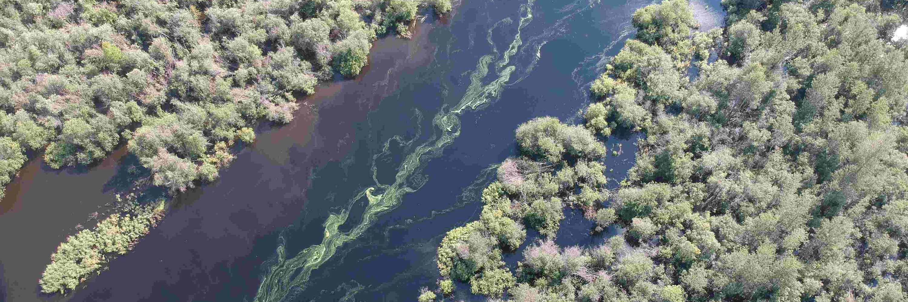
We look at organic matter, nutrients, and mercury primarily. But also sediment and other aspects. Early results do not show major impacts of the fire, but this has been expected due to the continuing drought - we are on our toes to sample if wetter conditions flush the soils.
July 18, 2025 at 3:47 PM
We look at organic matter, nutrients, and mercury primarily. But also sediment and other aspects. Early results do not show major impacts of the fire, but this has been expected due to the continuing drought - we are on our toes to sample if wetter conditions flush the soils.
The black lines are the roads which we collect water samples along - shown with the historical fire map you can see that ~half of this large region has burned in the last few years. There are community concerns about impacts of wildfires and permafrost thaw on water and traditional land use.


July 17, 2025 at 11:29 PM
The black lines are the roads which we collect water samples along - shown with the historical fire map you can see that ~half of this large region has burned in the last few years. There are community concerns about impacts of wildfires and permafrost thaw on water and traditional land use.