


The Old Map Gallery
@oldmapgallery.bsky.social
Following the historical journey of discovery and understanding, through maps, charts and every significant data visualization we can find.
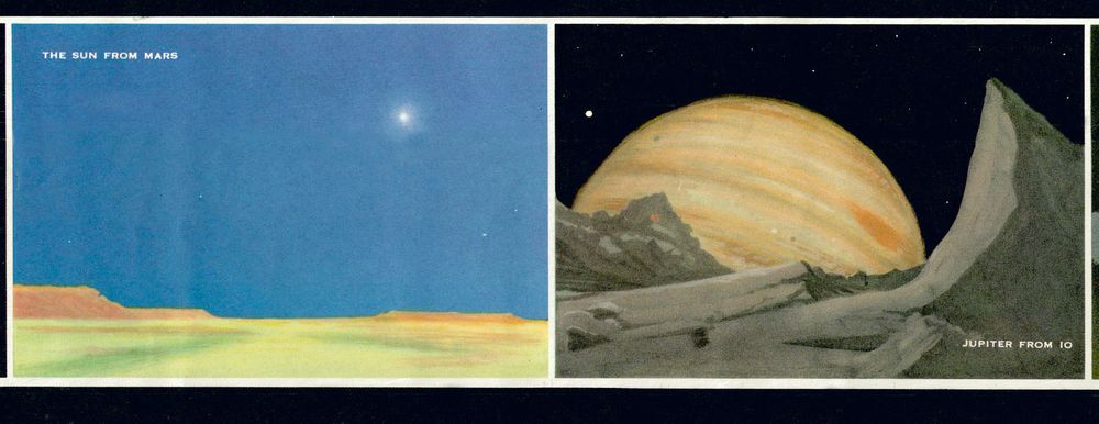
While it had been an international fascination long before America arrived, the U.S. certainly made impacts in the field, beyond the Wright brothers and Robert Goddard. The manufacturers, test pilots, military programs, on to the Space race. Here an overview.
#map #flight #maps #history
#map #flight #maps #history

December 3, 2025 at 4:12 PM
It wasn't Fulton.He didn't invent steamboats.
Here Mr Hutchings proves, w/ witness testimony, that he & Mr Fitch had done it decades prior.
Often an individual is imbued with the entirety of a development & invention, when actually, it's often a community/lineage of work that did it. #maps #history
Here Mr Hutchings proves, w/ witness testimony, that he & Mr Fitch had done it decades prior.
Often an individual is imbued with the entirety of a development & invention, when actually, it's often a community/lineage of work that did it. #maps #history

December 1, 2025 at 4:11 PM

In stumbling through estates and sales, we sometimes find interesting postcards. France in the early 20th century.
#politics #elections
#politics #elections

November 15, 2025 at 5:15 PM
In stumbling through estates and sales, we sometimes find interesting postcards. France in the early 20th century.
#politics #elections
#politics #elections
Keeping up.
What was going to be native lands west of the Mississippi river, at one time, was now rapidly being divided into territories.
This map was published c. 1855, but an owner tried to keep up in the 1860's & brushed in new CO. & Dakota terrs.
#maps #history #map #Nebraska #Kansas #Colorado
What was going to be native lands west of the Mississippi river, at one time, was now rapidly being divided into territories.
This map was published c. 1855, but an owner tried to keep up in the 1860's & brushed in new CO. & Dakota terrs.
#maps #history #map #Nebraska #Kansas #Colorado

November 14, 2025 at 2:07 AM
In 1862, if you were introducing the geographical world to young people, you'd probably mention popular explorers, many wouldn't show the recent addition of submarine cable.
That cable is the infrastructure precursor to things like international calling & the internet.
#maps #history #map #tech
That cable is the infrastructure precursor to things like international calling & the internet.
#maps #history #map #tech

November 11, 2025 at 9:27 PM

Space Invader hasn't just made street art, but started a dialogue and community. Making his video game and pop culture inspired tile works, he put them up around cities, and made maps to curate a tour of his works. He later made an app for phones to find and log his work.
#maps #art #map #streetart
#maps #art #map #streetart


October 9, 2025 at 2:03 AM
Space Invader hasn't just made street art, but started a dialogue and community. Making his video game and pop culture inspired tile works, he put them up around cities, and made maps to curate a tour of his works. He later made an app for phones to find and log his work.
#maps #art #map #streetart
#maps #art #map #streetart
From Stone Henge (on the left, from 1953) to Burning Man (on the right, 2008), ritual/ceremonial sites are fascinating.
Humans have a track record for meeting at specific places at specific times, and sometimes they look kinda similar
#maps #science #map #history #archaeology
Humans have a track record for meeting at specific places at specific times, and sometimes they look kinda similar
#maps #science #map #history #archaeology

September 30, 2025 at 10:38 PM
From Stone Henge (on the left, from 1953) to Burning Man (on the right, 2008), ritual/ceremonial sites are fascinating.
Humans have a track record for meeting at specific places at specific times, and sometimes they look kinda similar
#maps #science #map #history #archaeology
Humans have a track record for meeting at specific places at specific times, and sometimes they look kinda similar
#maps #science #map #history #archaeology
Don't sleep on the U.S.G.S.
A classic masterpiece for the Grand Canyon which is easy to get absorbed into. The complexities of the region laid out in such elegant visual simplicity.
#maps #dataviz #map #datavizualition #grandcanyon
A classic masterpiece for the Grand Canyon which is easy to get absorbed into. The complexities of the region laid out in such elegant visual simplicity.
#maps #dataviz #map #datavizualition #grandcanyon

September 8, 2025 at 2:33 PM
Don't sleep on the U.S.G.S.
A classic masterpiece for the Grand Canyon which is easy to get absorbed into. The complexities of the region laid out in such elegant visual simplicity.
#maps #dataviz #map #datavizualition #grandcanyon
A classic masterpiece for the Grand Canyon which is easy to get absorbed into. The complexities of the region laid out in such elegant visual simplicity.
#maps #dataviz #map #datavizualition #grandcanyon

It's all the interesting chaotic moments I could hope to learn about the New York Marathon, from the time under Mayor Koch when the start cannon wouldn't work, to when the Hasidim sprayed hot runners, or the infamous runner that caught a train and got busted.
#maps #history #newyork #nyc #map
#maps #history #newyork #nyc #map

August 29, 2025 at 8:44 PM
A favorite dramatic depiction that includes the "Sea of the West", a vast inland sea that was hypothesized & grew into a recurrent feature on maps of early North America.
Dr McGuirk did the definitive study years back and made a webpage for his work...https://sea-of-the-west.info/introduction
Dr McGuirk did the definitive study years back and made a webpage for his work...https://sea-of-the-west.info/introduction

August 28, 2025 at 5:13 PM
A favorite dramatic depiction that includes the "Sea of the West", a vast inland sea that was hypothesized & grew into a recurrent feature on maps of early North America.
Dr McGuirk did the definitive study years back and made a webpage for his work...https://sea-of-the-west.info/introduction
Dr McGuirk did the definitive study years back and made a webpage for his work...https://sea-of-the-west.info/introduction
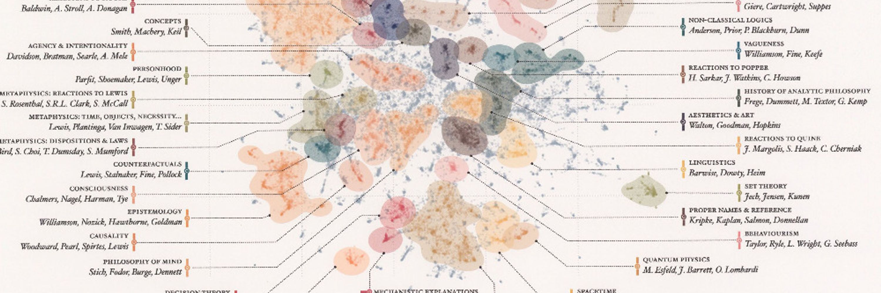
In a quick glimpse one might think, oh, a phylogenetic tree. Where are the eukaryotes?
But this instance of arborization is about computer evolution. Reaching back to Eniac and beyond, and as recent as the 1980's. Could be the roots of AGI?
#tech #computer #dataviz #technology #history
But this instance of arborization is about computer evolution. Reaching back to Eniac and beyond, and as recent as the 1980's. Could be the roots of AGI?
#tech #computer #dataviz #technology #history


August 27, 2025 at 3:49 PM
In a quick glimpse one might think, oh, a phylogenetic tree. Where are the eukaryotes?
But this instance of arborization is about computer evolution. Reaching back to Eniac and beyond, and as recent as the 1980's. Could be the roots of AGI?
#tech #computer #dataviz #technology #history
But this instance of arborization is about computer evolution. Reaching back to Eniac and beyond, and as recent as the 1980's. Could be the roots of AGI?
#tech #computer #dataviz #technology #history
From 1862, this was a comparative chart that provides you with the best of what was known for the major rivers and mountains of the world.
Great visualization let's you wander and discover, this does the job well
#maps #dataviz #map #history #datavisualization #mountains
Great visualization let's you wander and discover, this does the job well
#maps #dataviz #map #history #datavisualization #mountains

August 25, 2025 at 3:19 PM
From 1862, this was a comparative chart that provides you with the best of what was known for the major rivers and mountains of the world.
Great visualization let's you wander and discover, this does the job well
#maps #dataviz #map #history #datavisualization #mountains
Great visualization let's you wander and discover, this does the job well
#maps #dataviz #map #history #datavisualization #mountains

From the late 1950's a colorful push for people to consider visiting Ireland.
When you think about it there's too much to do, from great music & culture to the prehistoric sites that still hold mysteries.
(Could they use an antique map dealer w/ a love for Irish music?)
#ireland #maps #Irish #map
When you think about it there's too much to do, from great music & culture to the prehistoric sites that still hold mysteries.
(Could they use an antique map dealer w/ a love for Irish music?)
#ireland #maps #Irish #map


July 15, 2025 at 9:50 PM
Growing upward.
NYC before skyscrapers.
But with the recent addition of a bridge connecting to Brooklyn, change was underway. Architectural historians relates how people first walking across the bridge were amazed to look down & see birds flying beneath them.
#architecture #maps #NYC #map #history
NYC before skyscrapers.
But with the recent addition of a bridge connecting to Brooklyn, change was underway. Architectural historians relates how people first walking across the bridge were amazed to look down & see birds flying beneath them.
#architecture #maps #NYC #map #history

July 8, 2025 at 2:05 PM
Growing upward.
NYC before skyscrapers.
But with the recent addition of a bridge connecting to Brooklyn, change was underway. Architectural historians relates how people first walking across the bridge were amazed to look down & see birds flying beneath them.
#architecture #maps #NYC #map #history
NYC before skyscrapers.
But with the recent addition of a bridge connecting to Brooklyn, change was underway. Architectural historians relates how people first walking across the bridge were amazed to look down & see birds flying beneath them.
#architecture #maps #NYC #map #history

10 orbits.
Apollo 8 would be the first time humanity went around our ancient nearest neighbor, the moon. Taking about 6 days to get there & back, a massive step for humans exploring the solar system.
Looking at the arc of human history, a significant moment.
#moon #space #map #history #maps
Apollo 8 would be the first time humanity went around our ancient nearest neighbor, the moon. Taking about 6 days to get there & back, a massive step for humans exploring the solar system.
Looking at the arc of human history, a significant moment.
#moon #space #map #history #maps

July 3, 2025 at 2:07 PM

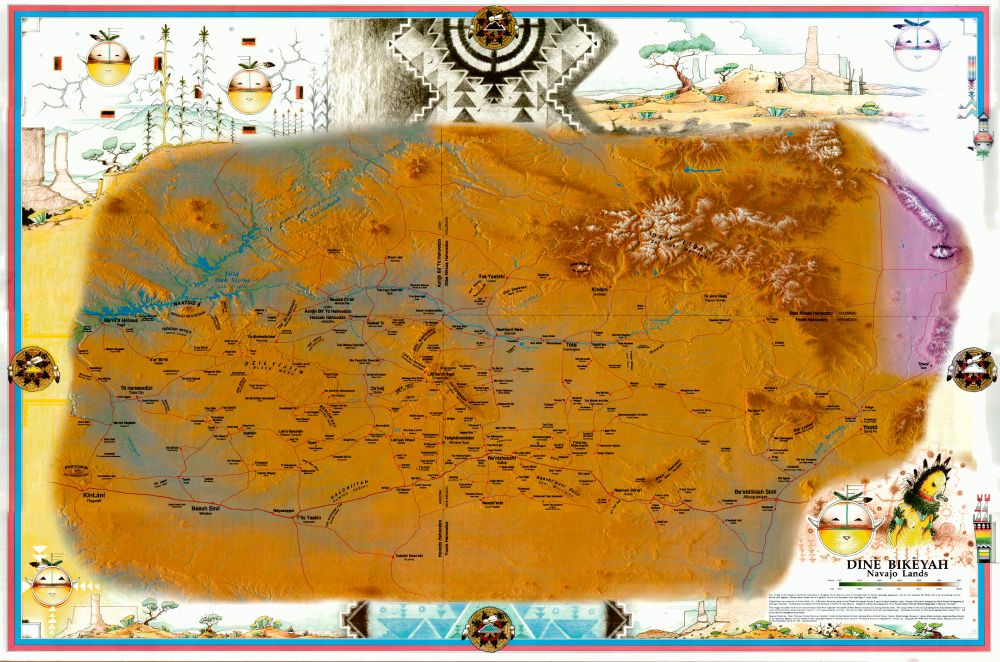
Love this Dine published map for their homeland in the Southwest where they identify and reclaim the lands identity.
#Native #maps #NativeAmerican #map #history
#Native #maps #NativeAmerican #map #history
May 6, 2025 at 4:18 PM
Love this Dine published map for their homeland in the Southwest where they identify and reclaim the lands identity.
#Native #maps #NativeAmerican #map #history
#Native #maps #NativeAmerican #map #history
From 1841, a fine example of the changing West & territories. Shows intended permanent Indian lands of the plains, (wouldn't last a decade)
Also a funny data viz cheat. If you have a large "Unexplored Region" mask your ignorance, add a distance chart.
#maps #Native #map #NativeAmerican #dataviz
Also a funny data viz cheat. If you have a large "Unexplored Region" mask your ignorance, add a distance chart.
#maps #Native #map #NativeAmerican #dataviz

May 2, 2025 at 4:37 PM
From 1841, a fine example of the changing West & territories. Shows intended permanent Indian lands of the plains, (wouldn't last a decade)
Also a funny data viz cheat. If you have a large "Unexplored Region" mask your ignorance, add a distance chart.
#maps #Native #map #NativeAmerican #dataviz
Also a funny data viz cheat. If you have a large "Unexplored Region" mask your ignorance, add a distance chart.
#maps #Native #map #NativeAmerican #dataviz


The plains of Colorado had their zenith in the early 20th century, prior to the Dust Bowl. It's been declining since. But for one moment in the 1990's a few counties sought to rebrand as "Colorado's Outback", piggybacking off the Crocodile Dundee films(?).
It didn't take.
#map #Colorado #maps
It didn't take.
#map #Colorado #maps

April 5, 2025 at 9:10 PM