


NWS Milwaukee (Unofficial Mirror)
@nwsmilwaukee.bsky.social
Unofficial mirror of the National Weather Service Milwaukee X Feed (@NWSMilwaukee).
Not affiliated with NOAA/NWS.
Comments are not monitored, and posts may not be timely.
Visit Details: https://www.weather.gov/milwaukee for official information
Not affiliated with NOAA/NWS.
Comments are not monitored, and posts may not be timely.
Visit Details: https://www.weather.gov/milwaukee for official information
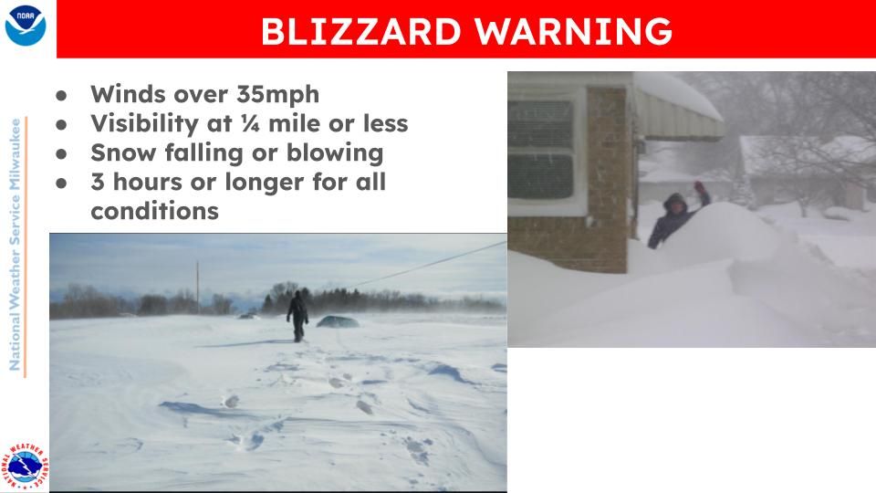
Today is the last day of Winter Weather Awareness Week in WI. Today we're talking about Snow Squalls. Snow Squall Warnings occur when there's a 30-60 minute long period of intense bursts of snow and wind that causes whiteout conditions and rapidly deteriorating road conditions.

November 21, 2025 at 2:23 PM
Today is the last day of Winter Weather Awareness Week in WI. Today we're talking about Snow Squalls. Snow Squall Warnings occur when there's a 30-60 minute long period of intense bursts of snow and wind that causes whiteout conditions and rapidly deteriorating road conditions.
It's Winter Weather Awareness Week in WI...today we're talking about cold weather! Our terminology for these headlines and the thresholds for a warning changed last year. Here are the statewide thresholds for a warning and advisory. #wiwx

November 20, 2025 at 4:26 PM
It's Winter Weather Awareness Week in WI...today we're talking about cold weather! Our terminology for these headlines and the thresholds for a warning changed last year. Here are the statewide thresholds for a warning and advisory. #wiwx
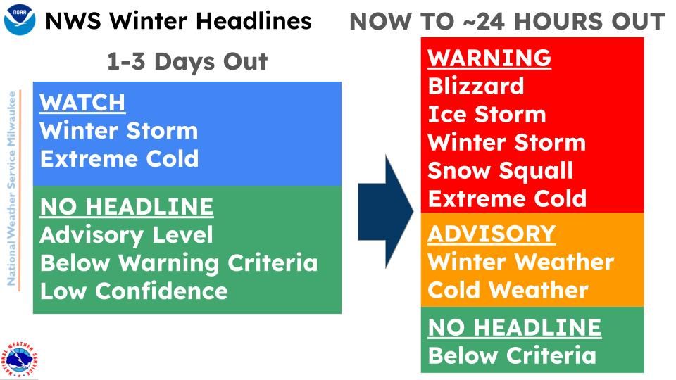
For Winter WX Awareness Week in WI...here's our criteria for issuing different warnings and advisories. Typically these are issued within 24 hours of when the main impacts are expected for the winter event. #wiwx


November 19, 2025 at 3:37 PM
For Winter WX Awareness Week in WI...here's our criteria for issuing different warnings and advisories. Typically these are issued within 24 hours of when the main impacts are expected for the winter event. #wiwx
It's Winter Weather Awareness Week in WI...do you know what headlines we issue? 1-3 days out is when we'd issue a 'Watch'. W/in 24 hours of the event beginning is when we'd go to warning, advisory or nothing. The headline is meant to get your attention that something is coming.
November 19, 2025 at 3:09 PM
It's Winter Weather Awareness Week in WI...do you know what headlines we issue? 1-3 days out is when we'd issue a 'Watch'. W/in 24 hours of the event beginning is when we'd go to warning, advisory or nothing. The headline is meant to get your attention that something is coming.
Dense Fog Advisory issued for visibility of <1/4 mile and patchy slick spots on elevated roadways thru 9 AM this morning. Use caution if traveling in advised area. #wiwx

November 19, 2025 at 9:53 AM
Dense Fog Advisory issued for visibility of <1/4 mile and patchy slick spots on elevated roadways thru 9 AM this morning. Use caution if traveling in advised area. #wiwx
Light accumulating snow for eastern and northern Sheboygan County and far northern Fond du Lac County through 2 PM. Under an inch on grassy surfaces. A little slush may accumulate on roads so please slow down if traveling. #swiwx

November 18, 2025 at 8:53 PM
Light accumulating snow for eastern and northern Sheboygan County and far northern Fond du Lac County through 2 PM. Under an inch on grassy surfaces. A little slush may accumulate on roads so please slow down if traveling. #swiwx
Burst of light snow over eastern Sheboygan County including the city of Sheboygan. Slushy and slippery roads may occur. Slow down if traveling. #swiwx

November 18, 2025 at 8:53 PM
Burst of light snow over eastern Sheboygan County including the city of Sheboygan. Slushy and slippery roads may occur. Slow down if traveling. #swiwx
It's Winter Weather Awareness Week and we're talking about Lake Effect Snow. For those along Lake Michigan, particularly Racine/Kenosha, you already know about how intense these snow bands can be, particularly early in the season when the lake is warmer compared to late winter.

November 18, 2025 at 7:21 PM
It's Winter Weather Awareness Week and we're talking about Lake Effect Snow. For those along Lake Michigan, particularly Racine/Kenosha, you already know about how intense these snow bands can be, particularly early in the season when the lake is warmer compared to late winter.
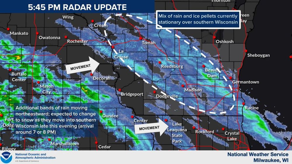
Still see the band of rain contend with the warmer air delaying the transition to a wintry mix and snow. However, still expecting to see things switch to snow through daybreak for parts of central WI that may pick up an inch or so of slushy accumulations. #wiwx

November 18, 2025 at 11:07 AM
Still see the band of rain contend with the warmer air delaying the transition to a wintry mix and snow. However, still expecting to see things switch to snow through daybreak for parts of central WI that may pick up an inch or so of slushy accumulations. #wiwx
Although a bit slower arrival, band of rain/wintry mix spreading northeastward overnight. Wintry mix continues across much of the area overnight due to warmer temps, but transition to snow with a some slushy accumulations north of Madison into the morning. #wiwx

November 18, 2025 at 6:20 AM
Although a bit slower arrival, band of rain/wintry mix spreading northeastward overnight. Wintry mix continues across much of the area overnight due to warmer temps, but transition to snow with a some slushy accumulations north of Madison into the morning. #wiwx
Although a bit slower arrival, band of rain/wintry mix spreading northeastward overnight. Wintry mix continues across much of the area overnight due to warmer temps, but transition to snow with a some slushy accumulations north of Madison into the morning. #wiwx

November 18, 2025 at 6:19 AM
Although a bit slower arrival, band of rain/wintry mix spreading northeastward overnight. Wintry mix continues across much of the area overnight due to warmer temps, but transition to snow with a some slushy accumulations north of Madison into the morning. #wiwx
Still forecasting a band of rain/snow mix to cross the region tonight into Tuesday, with a transition to all snow in Central WI allowing for ~1-2" accumulations (with the majority occurring between 3 AM and 9 AM Tue). Mostly rain in the mix further south and east. #wiwx #sewiwx


November 18, 2025 at 2:36 AM
Today begins Winter Weather Awareness Week in WI! With a snow/rain mix in the forecast tonight/tomorrow morning, we thought we'd share this graphic that shows how the different precipitation types occur. Warm air above the ground (like tonight) affects what type we get. #wiwx

November 17, 2025 at 7:52 PM
Today begins Winter Weather Awareness Week in WI! With a snow/rain mix in the forecast tonight/tomorrow morning, we thought we'd share this graphic that shows how the different precipitation types occur. Warm air above the ground (like tonight) affects what type we get. #wiwx
Band of steady light snow is expected to develop tonight with slushy accumulations for areas north and west of Madison. Expect to see impacts from accumulating snowfall linger into Tue AM commute. Light snow to wintry mix expected outside of band of snow. #wiwx

November 17, 2025 at 7:52 PM
Band of steady light snow is expected to develop tonight with slushy accumulations for areas north and west of Madison. Expect to see impacts from accumulating snowfall linger into Tue AM commute. Light snow to wintry mix expected outside of band of snow. #wiwx

Mdt-heavy lake effect snow to continue over far ern Racine and Kenosha Counties through 5-6 AM; lighter snow for far se MKE County. #swiwx

November 11, 2025 at 6:10 AM
Mdt-heavy lake effect snow to continue over far ern Racine and Kenosha Counties through 5-6 AM; lighter snow for far se MKE County. #swiwx
Mdt-heavy lake effect snow continues over far ern Racine and Kenosha Counties. Intermittent snow expected over far se MKE county. See the graphic for more details. #swiwx

November 11, 2025 at 6:10 AM
Mdt-heavy lake effect snow continues over far ern Racine and Kenosha Counties. Intermittent snow expected over far se MKE county. See the graphic for more details. #swiwx


A Winter Weather Advisory is in effect for Milwaukee, Racine, and Kenosha counties this evening through tonight. Snow totals of 2 to 5 inches are currently expected, but any small wobbles west or east to the snow band would result in greater or lesser amounts. #wiwx

November 10, 2025 at 6:10 AM
A Winter Weather Advisory is in effect for Milwaukee, Racine, and Kenosha counties this evening through tonight. Snow totals of 2 to 5 inches are currently expected, but any small wobbles west or east to the snow band would result in greater or lesser amounts. #wiwx
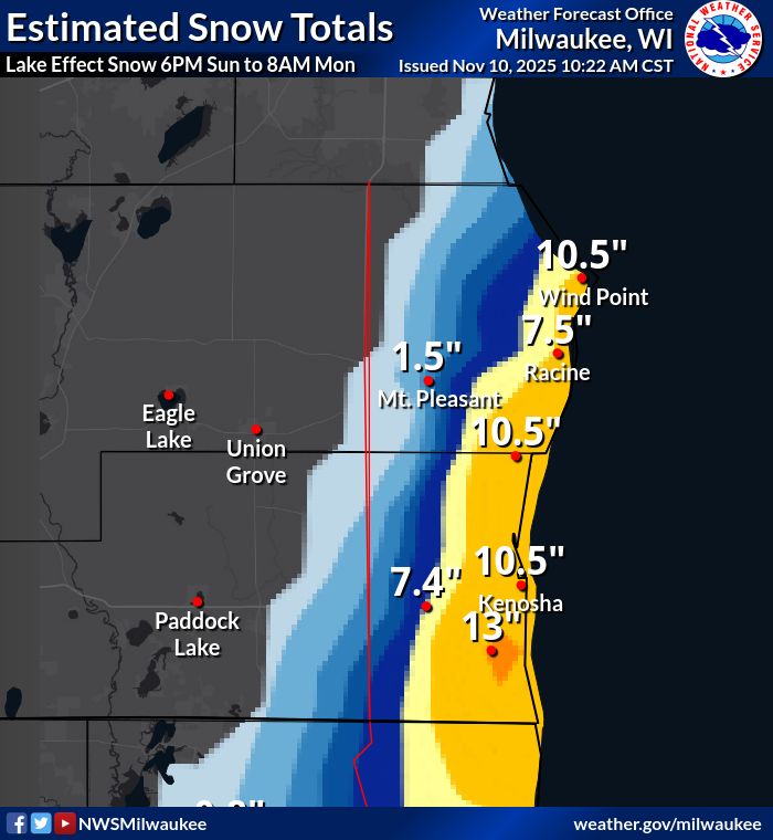
There is a potential for a heavy lake effect snow to come onshore tonight and affect the cities of Racine, Kenosha, and possibly far southeast Milwaukee County. It is also possible the lake effect snow stays over the lake. See the graphic. #swiwx

November 10, 2025 at 6:10 AM
There is a potential for a heavy lake effect snow to come onshore tonight and affect the cities of Racine, Kenosha, and possibly far southeast Milwaukee County. It is also possible the lake effect snow stays over the lake. See the graphic. #swiwx
Light snow lingers, with a rain/snow mix near Lake Michigan. This should gradually taper off overnight. Wet, slushy accumulations under one inch are possible on grassy and elevated surfaces. Slow down and drive carefully, as slick spots may result in these areas. #swiwx #wiwx

November 9, 2025 at 6:10 AM