


Noah Haggerty
@nohaggerty.bsky.social
Wildfire and clean energy reporter at the Los Angeles Times. Retired rookie physicist
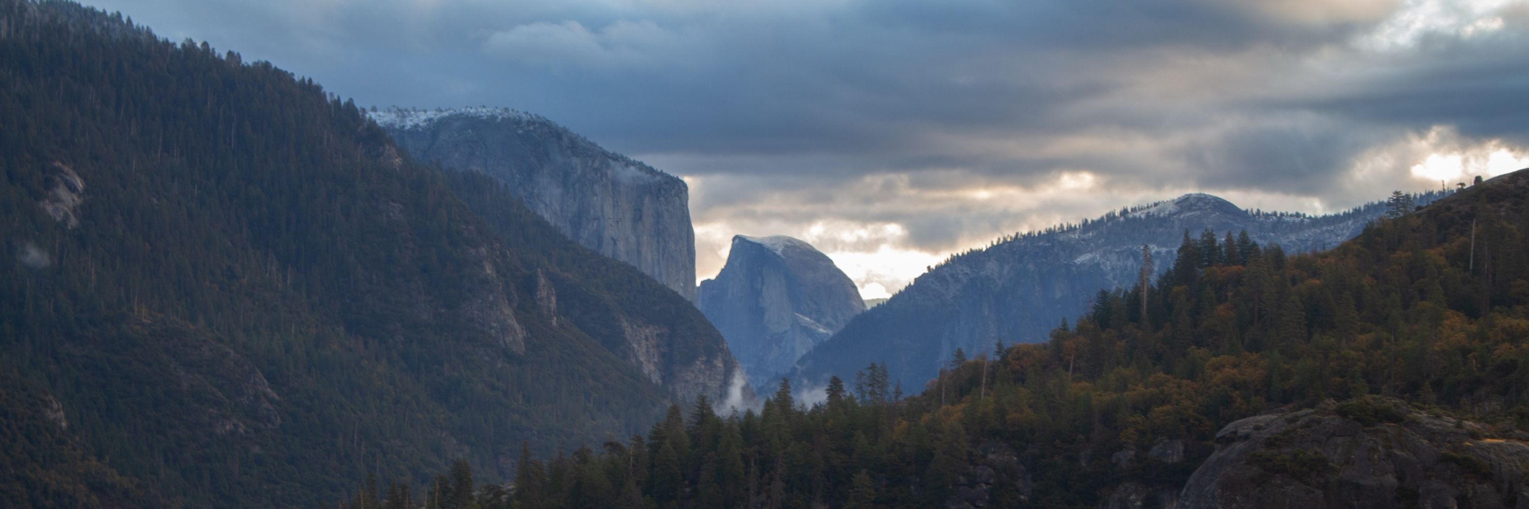
Beautiful special section in today’s LA Times with some thoughtful pieces about how we ought to rethink our relationship with fire. Read it here: www.latimes.com/california/s...

August 10, 2025 at 7:48 PM
Beautiful special section in today’s LA Times with some thoughtful pieces about how we ought to rethink our relationship with fire. Read it here: www.latimes.com/california/s...
Cal Fire has been steadily growing its ranks for years (thanks to increasing funding from the state government). As of this July, Cal Fire has 12,223 employees, beating 2024’s peak of 11,754.


July 28, 2025 at 4:58 PM
Cal Fire has been steadily growing its ranks for years (thanks to increasing funding from the state government). As of this July, Cal Fire has 12,223 employees, beating 2024’s peak of 11,754.
Last night’s sunset lighting up the smoke from the Dragon Bravo fire at the Grand Canyon
While fire crews work tirelessly along the North Rim to contain the blaze, life is continuing pretty much as usual for tourists along the (more popular) South Rim
While fire crews work tirelessly along the North Rim to contain the blaze, life is continuing pretty much as usual for tourists along the (more popular) South Rim
July 21, 2025 at 2:49 PM
Last night’s sunset lighting up the smoke from the Dragon Bravo fire at the Grand Canyon
While fire crews work tirelessly along the North Rim to contain the blaze, life is continuing pretty much as usual for tourists along the (more popular) South Rim
While fire crews work tirelessly along the North Rim to contain the blaze, life is continuing pretty much as usual for tourists along the (more popular) South Rim
California’s state fire department just released a cool new dataset 👀 How long does it take a forest to recover after a fire? See for yourself: experience.arcgis.com/experience/a...

July 15, 2025 at 11:57 PM
California’s state fire department just released a cool new dataset 👀 How long does it take a forest to recover after a fire? See for yourself: experience.arcgis.com/experience/a...
Watched police remove climate protestors in copenhagen this morning (I was on a run)
The group, Nødbremsen (which translates to “The Emergency Brake”) is protesting rising public transit fares amid a nearly $5 billion project to expand highways: www.noedbremsen.dk
The group, Nødbremsen (which translates to “The Emergency Brake”) is protesting rising public transit fares amid a nearly $5 billion project to expand highways: www.noedbremsen.dk


June 18, 2025 at 7:53 AM
Watched police remove climate protestors in copenhagen this morning (I was on a run)
The group, Nødbremsen (which translates to “The Emergency Brake”) is protesting rising public transit fares amid a nearly $5 billion project to expand highways: www.noedbremsen.dk
The group, Nødbremsen (which translates to “The Emergency Brake”) is protesting rising public transit fares amid a nearly $5 billion project to expand highways: www.noedbremsen.dk
FEMA refused to test residents’ soil in the Eaton and Palisades burn areas for potentially hazardous fire contaminants. So, we did it ourselves. Read our full investigation for @latimes.com here: www.latimes.com/environment/...
May 4, 2025 at 5:40 PM
FEMA refused to test residents’ soil in the Eaton and Palisades burn areas for potentially hazardous fire contaminants. So, we did it ourselves. Read our full investigation for @latimes.com here: www.latimes.com/environment/...
Fire departments across the state regularly inspect properties in higher hazard zones to make sure they comply with defensible space requirements. Violators are subject to fees and, in extreme cases, a misdemeanor charge.
April 3, 2025 at 2:43 PM
Fire departments across the state regularly inspect properties in higher hazard zones to make sure they comply with defensible space requirements. Violators are subject to fees and, in extreme cases, a misdemeanor charge.
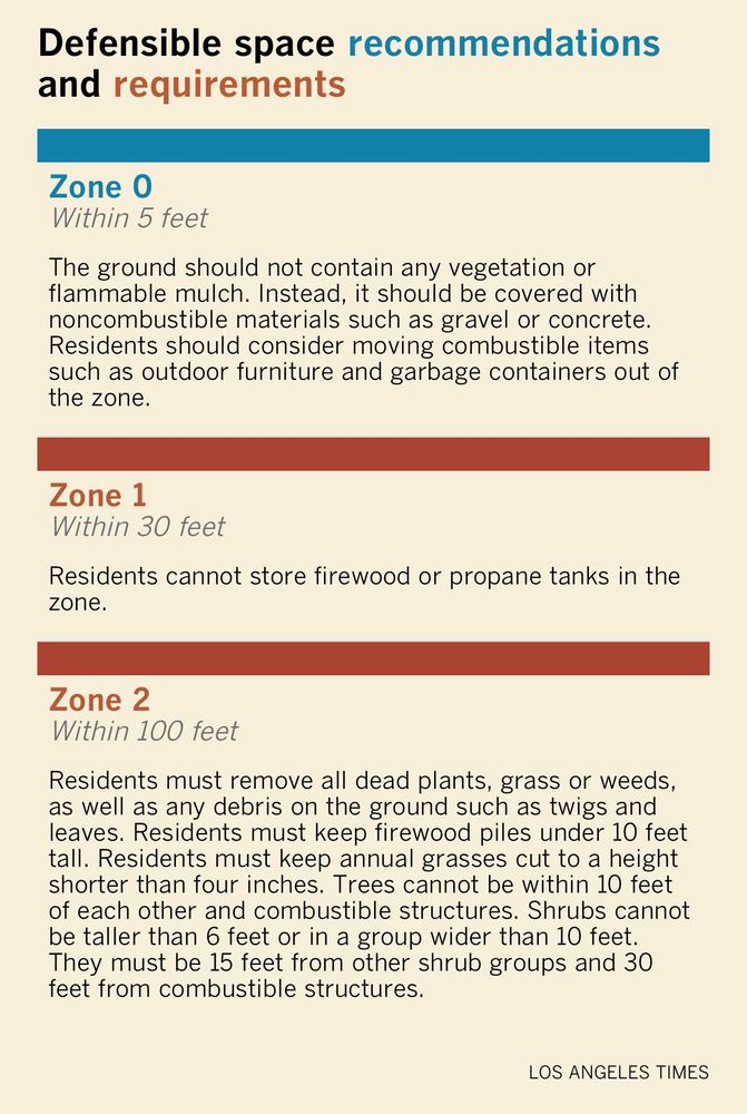
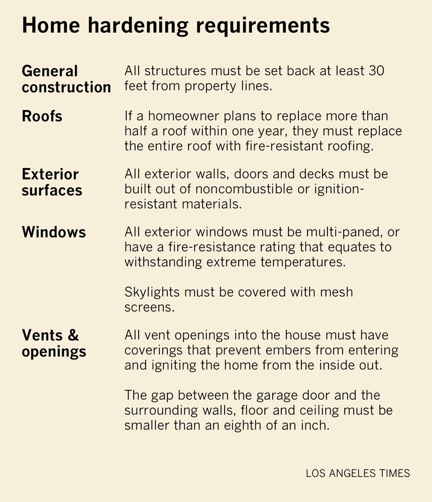
The biggest lifts for homeowners are the defensible space and home hardening requirements in the higher hazard zones. The home hardening building codes only kick in for new construction:
April 3, 2025 at 2:43 PM
The biggest lifts for homeowners are the defensible space and home hardening requirements in the higher hazard zones. The home hardening building codes only kick in for new construction:
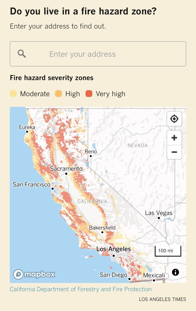
First — do you live in a zone? LA Times map wizard @sean-greene.bsky.social has you covered.
April 3, 2025 at 2:43 PM
First — do you live in a zone? LA Times map wizard @sean-greene.bsky.social has you covered.
The San Jose area was hit hard. When the legislature required Cal Fire to make these maps, it extended fire safety regulations for "very high" zones into the "high" zones. Much of the developed land pushing into Diablo Range and toward the coastal redwoods fall in this new zone.

February 25, 2025 at 6:21 PM
The San Jose area was hit hard. When the legislature required Cal Fire to make these maps, it extended fire safety regulations for "very high" zones into the "high" zones. Much of the developed land pushing into Diablo Range and toward the coastal redwoods fall in this new zone.
However, the east bay area, including Berkeley and Oakland saw significant decreases. Cal Fire wouldn't comment on specific cities, but pointed to new data, modeling methods and the development of wildlands into suburban/urban areas as significant causes of change.

February 25, 2025 at 6:21 PM
However, the east bay area, including Berkeley and Oakland saw significant decreases. Cal Fire wouldn't comment on specific cities, but pointed to new data, modeling methods and the development of wildlands into suburban/urban areas as significant causes of change.
Wildfire is scary. The LA fires are a reminder that virtually no one in this state is free of fire risk. So, every week, our stellar team of @latimes.com reporters will help you get a little more prepared for the next one with our new newsletter. Sign up here: www.latimes.com/archives/sig...

February 25, 2025 at 4:23 PM
Wildfire is scary. The LA fires are a reminder that virtually no one in this state is free of fire risk. So, every week, our stellar team of @latimes.com reporters will help you get a little more prepared for the next one with our new newsletter. Sign up here: www.latimes.com/archives/sig...
The new Cal Fire maps are just for the areas where local fire departments are responsible for responding to blazes (Local Responsibility Areas). The agency released maps for the land where Cal Fire is responsible for putting out fires (State Responsibility Areas) back in 2023.

February 13, 2025 at 5:40 PM
The new Cal Fire maps are just for the areas where local fire departments are responsible for responding to blazes (Local Responsibility Areas). The agency released maps for the land where Cal Fire is responsible for putting out fires (State Responsibility Areas) back in 2023.
Redding also saw a decrease in its "very high" zone, but the new "high" zone — that the state will now expand many regulations into — more than makes up for that decrease.

February 13, 2025 at 5:40 PM
Redding also saw a decrease in its "very high" zone, but the new "high" zone — that the state will now expand many regulations into — more than makes up for that decrease.
The one exception? Placerville, California. Many cities saw increases because Cal Fire used more up to date climate and extreme weather data — and it's the first time they've mapped the "high" zone. Right now, it's unclear why Placerville saw such a large decrease.

February 13, 2025 at 5:40 PM
The one exception? Placerville, California. Many cities saw increases because Cal Fire used more up to date climate and extreme weather data — and it's the first time they've mapped the "high" zone. Right now, it's unclear why Placerville saw such a large decrease.
Out of the 35 cities and towns Cal Fire mapped, all but one saw increases in the number of acres in the two highest zones where most heightened fire regulations apply. Chico and Truckee saw the biggest increases from the 2011 zones (Graphics by the incredible @sean-greene.bsky.social)

February 13, 2025 at 5:40 PM
Out of the 35 cities and towns Cal Fire mapped, all but one saw increases in the number of acres in the two highest zones where most heightened fire regulations apply. Chico and Truckee saw the biggest increases from the 2011 zones (Graphics by the incredible @sean-greene.bsky.social)
On today’s @latimes.com front page, our story on what Cal Fire missed in its fire hazard modeling for Altadena: www.latimes.com/environment/...

February 6, 2025 at 6:03 PM
On today’s @latimes.com front page, our story on what Cal Fire missed in its fire hazard modeling for Altadena: www.latimes.com/environment/...
Here's Cal Fire's zoning compared to First Street's fire risk assessment and the Eaton perimeter. Cal Fire's mapping only currently uses one ranking whereas First Street's uses a scale. The state agency says its maps are designed to determine where regulations apply, not to inform the public:

February 5, 2025 at 4:41 PM
Here's Cal Fire's zoning compared to First Street's fire risk assessment and the Eaton perimeter. Cal Fire's mapping only currently uses one ranking whereas First Street's uses a scale. The state agency says its maps are designed to determine where regulations apply, not to inform the public:
The last is PCH & Coastline, and the first three are just east/south of that along PCH:

January 9, 2025 at 4:51 AM
The last is PCH & Coastline, and the first three are just east/south of that along PCH:
Hi Erinn, Here’s what I have from around Castellammare/the Villa:


January 9, 2025 at 4:07 AM
Hi Erinn, Here’s what I have from around Castellammare/the Villa:
In many locations, the fire jumped over the highway and destroyed homes along the coast. PCH staples the Reel Inn and Moonshadows Malibu have been reduced to rubble.


January 9, 2025 at 1:48 AM
In many locations, the fire jumped over the highway and destroyed homes along the coast. PCH staples the Reel Inn and Moonshadows Malibu have been reduced to rubble.
As of 4 p.m. fire fighters were still battling large structural fires along the highway
January 9, 2025 at 1:48 AM
As of 4 p.m. fire fighters were still battling large structural fires along the highway
Scenes from the Pacific Coast Highway today🧵… So many of the iconic homes and landmarks — stretching all the way from Will Rogers to Carbon beach — are just … gone.
January 9, 2025 at 1:48 AM
Scenes from the Pacific Coast Highway today🧵… So many of the iconic homes and landmarks — stretching all the way from Will Rogers to Carbon beach — are just … gone.
obsessed with how the new KBBQ place in my hometown determines who gets the children’s discount

December 1, 2024 at 5:06 PM
obsessed with how the new KBBQ place in my hometown determines who gets the children’s discount
Cool graph: Support for more nuclear plants in the U.S. by party and age. Older Rs are motivated U.S. nuclear competitiveness, while younger Rs worry more about sticker price. Older Dems worry about enviro concerns and safety, while younger Dems are focused on climate change.

November 22, 2024 at 4:08 PM
Cool graph: Support for more nuclear plants in the U.S. by party and age. Older Rs are motivated U.S. nuclear competitiveness, while younger Rs worry more about sticker price. Older Dems worry about enviro concerns and safety, while younger Dems are focused on climate change.