


New England Storm Center
@nestormcenter.bsky.social
Complete New England Storm and weather coverage. Owner of NewEnglandStormCenter.com
New England's weather will remain mostly quiet through Thanksgiving. Some southern showers tomorrow morning with more showers from a low-impact system around mid-week. New England will once again be within a trough after Thanksgiving as colder air pours in. #MAwx #CTwx #RIwx #NHwx #MEwx #VTwx


November 22, 2025 at 1:00 AM
It's been a rather quick start to the winter season. Maximum snow depth for this date from the NWS snow analyses is 25.9", which is tied for 2nd highest since 2005 (some mountains in Vermont are reporting even more). 57.9% of northeast has snow cover, tied for 5th since 2005. #MAwx #VTwx #NHwx #MEwx


November 19, 2025 at 1:07 AM
It's been a rather quick start to the winter season. Maximum snow depth for this date from the NWS snow analyses is 25.9", which is tied for 2nd highest since 2005 (some mountains in Vermont are reporting even more). 57.9% of northeast has snow cover, tied for 5th since 2005. #MAwx #VTwx #NHwx #MEwx


A bit of a messy storm incoming with mild air running over cold air at the surface. Areas that are above freezing all the way to the ground at the start will see only rain. Moving north, things naturally get colder, as does the precip. type. #MAwx #CTwx #RIwx #NHwx #MEwx #VTwx


November 14, 2025 at 11:50 PM
New England's weekend storm will involve warm air running over cold air at the surface as a warm front lifts into New England. This is a prime setup for cold air damming and a wintry mix. Graphics below show the likely way this will play out. #MAwx #CTwx #RIwx #NHwx #MEwx #VTwx


November 13, 2025 at 11:36 PM
Unsettled weather continues with snow showers across the north amounting to another 1-3" through Friday as yet another shortwave passes. Sunday will be the next widespread system, which looks to be rain south with a mix changing to rain across the north. #MAwx #CTwx #RIwx #NHwx #MEwx #VTwx


November 13, 2025 at 12:09 AM
Broad cyclonic flow continues to hang over New England this week, keeping the breeze around. Additional snow showers and flurries are likely Wednesday as a subtle system passes to the north. Next organized systems comes Sunday with rain and a wintry mix. #MAwx #CTwx #RIwx #NHwx #MEwx #VTwx


November 12, 2025 at 1:04 AM


It's a snowy scene in northern Vermont this evening! Images below show Church Street in Burlington and Burlington Airport as of around 7:30pm. #VTwx


November 11, 2025 at 12:41 AM
It's a snowy scene in northern Vermont this evening! Images below show Church Street in Burlington and Burlington Airport as of around 7:30pm. #VTwx
Winter weather advisories are up for northern Vermont as rain changes to snow this evening behind the cold front. Additional snow showers are likely tomorrow afternoon as well. 1-3" is most likely with up to 5-6" for high elevations & summits #VTwx


November 10, 2025 at 8:55 PM
Winter weather advisories are up for northern Vermont as rain changes to snow this evening behind the cold front. Additional snow showers are likely tomorrow afternoon as well. 1-3" is most likely with up to 5-6" for high elevations & summits #VTwx
More rain, ice and snow is on the way for Monday and Monday night as an area of low pressure forms around coastal New England. Temps fall behind a cold front moving west to east Monday. New England remains in a trough for the rest of the week. #MAwx #CTwx #RIwx #NHwx #MEwx #VTwx
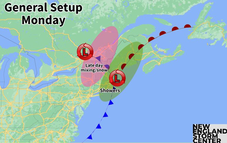


November 10, 2025 at 12:05 AM
The first winter weather advisories of the season for New England have been issued across northern Maine. 1-3 inches of snow and a trace of ice is possible tonight before milder air works in Monday morning. #MEwx

November 9, 2025 at 1:22 PM
The first winter weather advisories of the season for New England have been issued across northern Maine. 1-3 inches of snow and a trace of ice is possible tonight before milder air works in Monday morning. #MEwx
A warm front gets lifted toward New England Sunday. Much of northern New England stays north of the front, with a chance for morning mix/snow. Areas south of the front will see rain showers increase from south to north through the afternoon. #MAwx #CTwx #RIwx #NHwx #MEwx #VTwx


November 8, 2025 at 11:36 PM
New England's active, yet low-impact pattern continues with a quick system tonight followed by another Sunday to Monday. Next week sees things turn very chilly, but it will be the southeast that will bear the brunt of the coldest temps (relatives to averages) #MAwx #CTwx #RIwc #NHwx #MEwx #VTwx


November 7, 2025 at 11:48 PM
New England's active pattern continues with a weaker system passing north Friday night. This will put New England into the warm sector with lighter showers and less wind. Next system blows through Sun to Mon. A deep trough develops next week with chilly temps. #MAwx #CTwx #RIwx #NHwx #MEwx #VTwx


November 7, 2025 at 12:41 AM


Wind alerts are up for a good portion of New England as a strengthening clipper system approaches. Some mitigating factors may limit the wind from reaching its full potential, which is why high wind watches haven't been upgraded or downgraded yet (as of writing). #MAwx #CTwx #RIwx #NHwx #MEwx

November 5, 2025 at 4:43 PM
An impactful wind event is increasingly likely for Wednesday night to Thursday. Gusts of 40-65mph are possible as a strengthening clipper moves through. Highest winds southern half of New England. 1st snow of the season also likely for northernmost areas. #MAwx #CTwx #RIwx #NHwx #MEwx #VTwx


November 5, 2025 at 12:28 AM
About 18,500 are without power across New England. Last night's storm has intensified to the east. Central pressure has dropped sub-950mb. This creates an 80mb difference, with New England caught in the middle, producing all this wind. We do it again on Thursday. #MAwx #CTwx #RIwx #NHwx #MEwx #VTwx

November 4, 2025 at 4:38 PM
November is among the windiest months of the year for New England, and an active pattern this week will help keep gusts elevated. Windiest day will be tomorrow (a wind advisory is in effect for the eastern half of New England). Another windy day coming Thursday. #MAwx #CTwx #RIwx #NHwx #MEwx #VTwx


November 4, 2025 at 12:11 AM


