


Nate Howes TWN
@natetwnclimate.bsky.social
Digital reporter at @weathernetwork.bsky.social. Former Metroland Media reporter, The Sheridan Sun editor. Sheridan College print-journalism graduate. X: https://twitter.com/HowesNathan | Bio: https://www.theweathernetwork.com/en/news/author/nathan-howes

Incredibly early snow squall event across southern Ontario is turning heads and making driving treacherous and dangerous through Tuesday. @50shadesofvan.bsky.social on why the lake-effect machine is primed to deliver explosive snowfall rates. #onstorm #ONwx www.theweathernetwork.com/en/news/weat...


November 11, 2025 at 3:17 AM
Incredibly early snow squall event across southern Ontario is turning heads and making driving treacherous and dangerous through Tuesday. @50shadesofvan.bsky.social on why the lake-effect machine is primed to deliver explosive snowfall rates. #onstorm #ONwx www.theweathernetwork.com/en/news/weat...
5 p.m. #ONstorm snowfall summary, with data collected from @50shadesofvan.bsky.social. Hamilton: 13 cm, Toronto: 9 cm, Trenton: 9 cm, Ottawa: 5 cm, London: 4 cm.
Social media reports:
Hamilton Mountain: 16 cm, Kitchener-Waterloo: 9 cm, Chatham: 8 cm and Kingston: 7 cm. #onstorm #onwx
Social media reports:
Hamilton Mountain: 16 cm, Kitchener-Waterloo: 9 cm, Chatham: 8 cm and Kingston: 7 cm. #onstorm #onwx

November 9, 2025 at 10:55 PM
5 p.m. #ONstorm snowfall summary, with data collected from @50shadesofvan.bsky.social. Hamilton: 13 cm, Toronto: 9 cm, Trenton: 9 cm, Ottawa: 5 cm, London: 4 cm.
Social media reports:
Hamilton Mountain: 16 cm, Kitchener-Waterloo: 9 cm, Chatham: 8 cm and Kingston: 7 cm. #onstorm #onwx
Social media reports:
Hamilton Mountain: 16 cm, Kitchener-Waterloo: 9 cm, Chatham: 8 cm and Kingston: 7 cm. #onstorm #onwx


November 9, 2025 at 2:17 AM
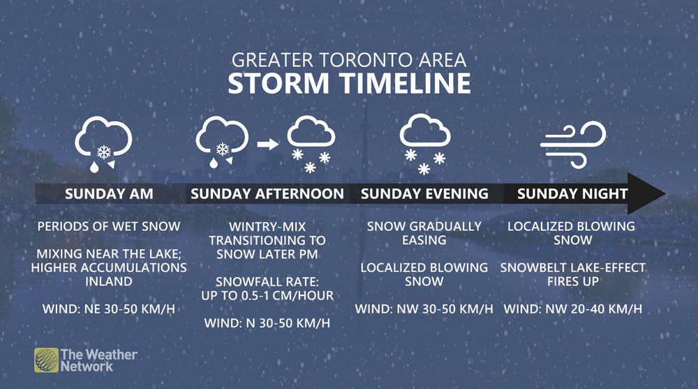
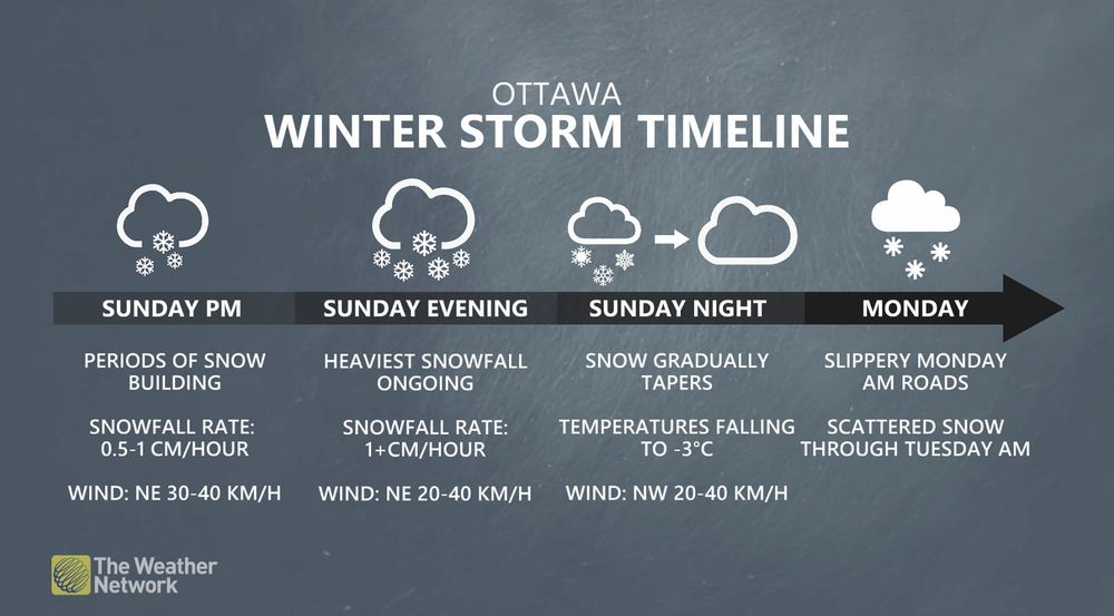

Mother Nature certainly isn't wasting any time giving southern Ontario a taste of what's to come. With 5-10+ cm of snow expected (15-20 cm in extreme east), drivers should exercise caution on roads, especially those without winter tires on. #onstorm #ONwx www.theweathernetwork.com/en/news/weat...


November 8, 2025 at 5:00 PM
Mother Nature certainly isn't wasting any time giving southern Ontario a taste of what's to come. With 5-10+ cm of snow expected (15-20 cm in extreme east), drivers should exercise caution on roads, especially those without winter tires on. #onstorm #ONwx www.theweathernetwork.com/en/news/weat...
A major snowfall to close out the weekend is targeting a good portion of Quebec, including Montreal, with totals of 10-30 cm possible. Drivers can expected slick roads and slow, difficult travel. #QCStorm #MeteoQC www.theweathernetwork.com/en/news/weat...


November 8, 2025 at 2:42 PM
A major snowfall to close out the weekend is targeting a good portion of Quebec, including Montreal, with totals of 10-30 cm possible. Drivers can expected slick roads and slow, difficult travel. #QCStorm #MeteoQC www.theweathernetwork.com/en/news/weat...
Oh, boy. It had to happen sooner or later. It is too early to have confidence in exactly where the bands will set up, and how much snow will fall, but some areas to the east and southeast of Lake Huron and Georgian Bay could see notable snow totals. Flurries are likely elsewhere. #ONwx

November 6, 2025 at 2:07 AM
Oh, boy. It had to happen sooner or later. It is too early to have confidence in exactly where the bands will set up, and how much snow will fall, but some areas to the east and southeast of Lake Huron and Georgian Bay could see notable snow totals. Flurries are likely elsewhere. #ONwx
As if time change wasn't already enough to adjust to, but Toronto will soon see dark days of winter, with afternoon sunsets upon us. After Friday, 5 p.m. sunsets in 2025 are over. It won't be until Jan. 10, 2026 that we see the sun set after 5 p.m. #ONwx www.theweathernetwork.com/en/news/weat...

November 5, 2025 at 11:10 PM
As if time change wasn't already enough to adjust to, but Toronto will soon see dark days of winter, with afternoon sunsets upon us. After Friday, 5 p.m. sunsets in 2025 are over. It won't be until Jan. 10, 2026 that we see the sun set after 5 p.m. #ONwx www.theweathernetwork.com/en/news/weat...
Lake-effect showers could develop overnight near Barrie, with brief, wet snowflakes possible in the Dundalk Highlands and snowbelt regions off Lake Huron and Georgian Bay. Accumulating snow is likely across the higher terrain in
Algonquin Provincial Park. #ONwx
Algonquin Provincial Park. #ONwx

November 5, 2025 at 3:55 AM
Lake-effect showers could develop overnight near Barrie, with brief, wet snowflakes possible in the Dundalk Highlands and snowbelt regions off Lake Huron and Georgian Bay. Accumulating snow is likely across the higher terrain in
Algonquin Provincial Park. #ONwx
Algonquin Provincial Park. #ONwx
Locally heavier showers are expected downwind of Lake Huron and Georgian Bay late Wednesday afternoon and evening. Isolated thunderstorms and lightning strikes are possible near the aforementioned bodies of water through the evening and overnight. #onstorm www.theweathernetwork.com/en/news/weat...

November 5, 2025 at 3:53 AM
Locally heavier showers are expected downwind of Lake Huron and Georgian Bay late Wednesday afternoon and evening. Isolated thunderstorms and lightning strikes are possible near the aforementioned bodies of water through the evening and overnight. #onstorm www.theweathernetwork.com/en/news/weat...
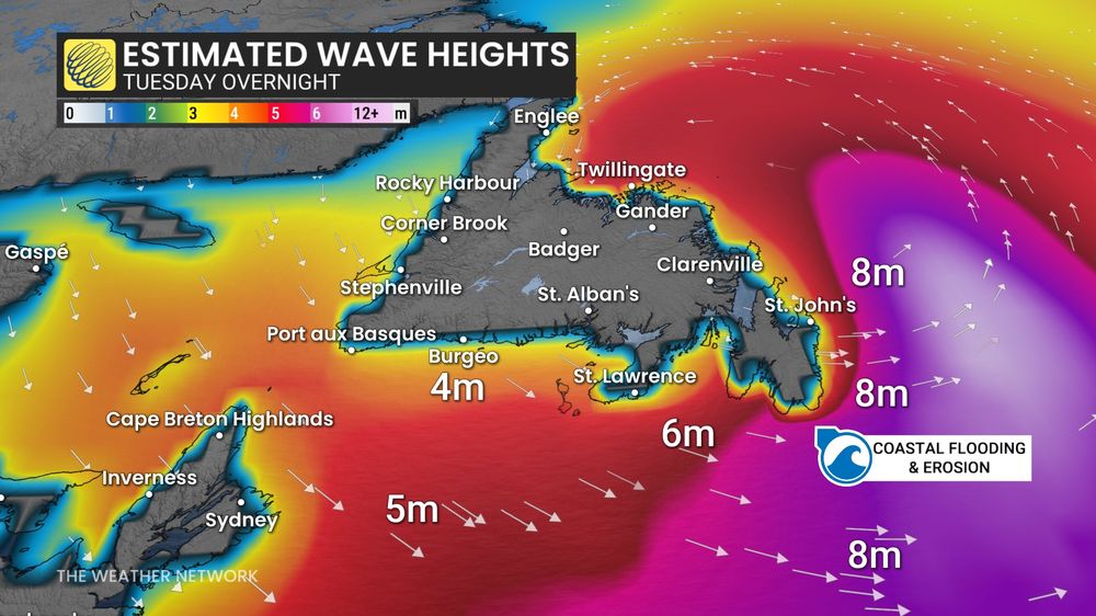
Impressive wind gusts documented in historic #nlwx weather bomb. Cape St. Mary's: 172 km/h, Cape Race: 162 km/h, Cape Pine Lightstation: 156 km/h, Sagona Island: 155 km/h, Trepassey: 152 km/h (personal station). New November pressure record in St. John's. www.theweathernetwork.com/en/news/weat...


November 5, 2025 at 3:10 AM
Impressive wind gusts documented in historic #nlwx weather bomb. Cape St. Mary's: 172 km/h, Cape Race: 162 km/h, Cape Pine Lightstation: 156 km/h, Sagona Island: 155 km/h, Trepassey: 152 km/h (personal station). New November pressure record in St. John's. www.theweathernetwork.com/en/news/weat...

This week could see the first accumulating snow of the season for some major cities in Alberta and Saskatchewan. Wet snow can be expected from Edmonton, Alta., to Saskatoon, Sask. Calgary will miss out. #ABwx #SKwx www.theweathernetwork.com/en/news/weat...

November 4, 2025 at 6:38 PM
This week could see the first accumulating snow of the season for some major cities in Alberta and Saskatchewan. Wet snow can be expected from Edmonton, Alta., to Saskatoon, Sask. Calgary will miss out. #ABwx #SKwx www.theweathernetwork.com/en/news/weat...
A volatile storm––potential weather bomb––will put Newfoundland in its crosshairs on Tuesday. Wild, possibly damaging 100+km/h winds, heavy rain and monster waves are possible, as well as the chance of new November low-pressure record in St. John's. #NLwx www.theweathernetwork.com/en/news/weat...


November 4, 2025 at 3:08 AM
A volatile storm––potential weather bomb––will put Newfoundland in its crosshairs on Tuesday. Wild, possibly damaging 100+km/h winds, heavy rain and monster waves are possible, as well as the chance of new November low-pressure record in St. John's. #NLwx www.theweathernetwork.com/en/news/weat...


This year's #PolarBearWeek theme is coexistence, highlighting the impacts of #ClimateChange, the power of innovation, community collaboration, and a focus on building a future where polar bears and people thrive together. @polarbearsinternational.org

November 2, 2025 at 7:19 PM
This year's #PolarBearWeek theme is coexistence, highlighting the impacts of #ClimateChange, the power of innovation, community collaboration, and a focus on building a future where polar bears and people thrive together. @polarbearsinternational.org
The trial period of Bear-dar was a "pretty good learning curve" in Churchill, Man., under different environments, said @polarbearsinternational.org's Geoff York, and a "real, thorough testing of the equipment" in Arctic weather conditions. #PolarBearWeek

November 2, 2025 at 7:14 PM
The trial period of Bear-dar was a "pretty good learning curve" in Churchill, Man., under different environments, said @polarbearsinternational.org's Geoff York, and a "real, thorough testing of the equipment" in Arctic weather conditions. #PolarBearWeek
Atlantic Canada is feeling the effects of a low tracking through the St. Lawrence, combined with the post-Tropical Storm #Melissa. Breezy conditions on Saturday for Maritimes with 60-90+ km/h winds and rough seas off coast. #NBstorm #NSstorm #PEstorm #NLwx www.theweathernetwork.com/en/news/weat...


November 1, 2025 at 2:30 PM
Despite how far the blue line is, I've seen some wet snowflakes mix in (Orillia). Talk about a #Halloween scare. #ONwx 🎃👻💀🧙♀️

October 31, 2025 at 5:22 PM
Despite how far the blue line is, I've seen some wet snowflakes mix in (Orillia). Talk about a #Halloween scare. #ONwx 🎃👻💀🧙♀️
Chilly temperatures with wind chills for trick-or-treating this evening. Dress warmly. #ONwx #Halloween 🎃👻🧙♀️

October 31, 2025 at 1:26 PM
Chilly temperatures with wind chills for trick-or-treating this evening. Dress warmly. #ONwx #Halloween 🎃👻🧙♀️
Despite dropping down to a Category 3 hurricane, #Melissa remains a powerful and threatening storm that could bring destructive impacts to #Cuba when it makes a secondary landfall. #Jamaica #HurricaneMelissa www.theweathernetwork.com/en/news/weat...

October 29, 2025 at 1:09 AM
Despite dropping down to a Category 3 hurricane, #Melissa remains a powerful and threatening storm that could bring destructive impacts to #Cuba when it makes a secondary landfall. #Jamaica #HurricaneMelissa www.theweathernetwork.com/en/news/weat...
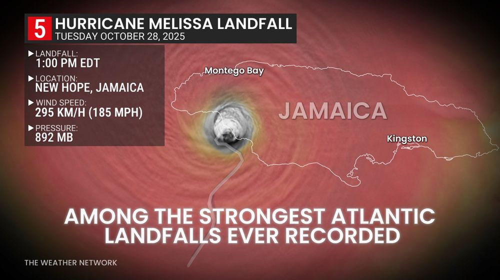
#HurricaneMelissa made landfall at 1 p.m. EDT in southwestern Jamaica, near New Hope, at Category 5 strength, boasting maximum, sustained winds of 295 km/h––one of the strongest Atlantic basin landfalls ever recorded. #Jamaica #Melissa
October 28, 2025 at 7:06 PM
#HurricaneMelissa made landfall at 1 p.m. EDT in southwestern Jamaica, near New Hope, at Category 5 strength, boasting maximum, sustained winds of 295 km/h––one of the strongest Atlantic basin landfalls ever recorded. #Jamaica #Melissa
@climate.noaa.gov look at #HurricaneMelissa. Catastrophic and life-threatening winds, flooding, and storm surge expected on Jamaica tonight and early Tuesday. Hurricane warning now extended to southeastern and central Bahamas.

October 27, 2025 at 10:22 PM
@climate.noaa.gov look at #HurricaneMelissa. Catastrophic and life-threatening winds, flooding, and storm surge expected on Jamaica tonight and early Tuesday. Hurricane warning now extended to southeastern and central Bahamas.