


Mike Gill
@mikegill.bsky.social
Archaeology, Neolithic, long barrows, landscape, GIS, geophysics. Community archaeology. Everton fan. Visiting Fellow Bournemouth University.
7/7 A PDF of the article on the newly discovered long barrow can be downloaded here: unearthinglongbarrows.co.uk/2025/10/04/a...

An Unrecorded Long Barrow near Morestead, Hampshire
by Michael Gill This article can be accessed / cited here: and is available for download as a PDF at the end of this article. Even though Neolithic long barrows are relatively rare, particularly in…
unearthinglongbarrows.co.uk
October 4, 2025 at 2:31 PM
7/7 A PDF of the article on the newly discovered long barrow can be downloaded here: unearthinglongbarrows.co.uk/2025/10/04/a...
6/7 This plot shows a wider context for the long barrows near Morestead (circled), showing the they are part of a cluster of long barrows on higher ground bracketed by the Itchen and Meon valleys

October 4, 2025 at 2:31 PM
6/7 This plot shows a wider context for the long barrows near Morestead (circled), showing the they are part of a cluster of long barrows on higher ground bracketed by the Itchen and Meon valleys
5/7 The three long barrows that cluster around this valley are compared in the following plot, showing their contrasting nature

October 4, 2025 at 2:31 PM
5/7 The three long barrows that cluster around this valley are compared in the following plot, showing their contrasting nature
4/7 Taking a slightly wider view, the Longwood long barrow sits just across the valley. This is another substantial barrow, suggesting the valley was of some importance in #Neolithic times

October 4, 2025 at 2:31 PM
4/7 Taking a slightly wider view, the Longwood long barrow sits just across the valley. This is another substantial barrow, suggesting the valley was of some importance in #Neolithic times
3/7 It is interesting that the newly discovered barrow is only 300m from the Warren Farm long barrow, recently shown to be a massive 135m in length - see t.co/UMN3LGY14l

October 4, 2025 at 2:31 PM
3/7 It is interesting that the newly discovered barrow is only 300m from the Warren Farm long barrow, recently shown to be a massive 135m in length - see t.co/UMN3LGY14l
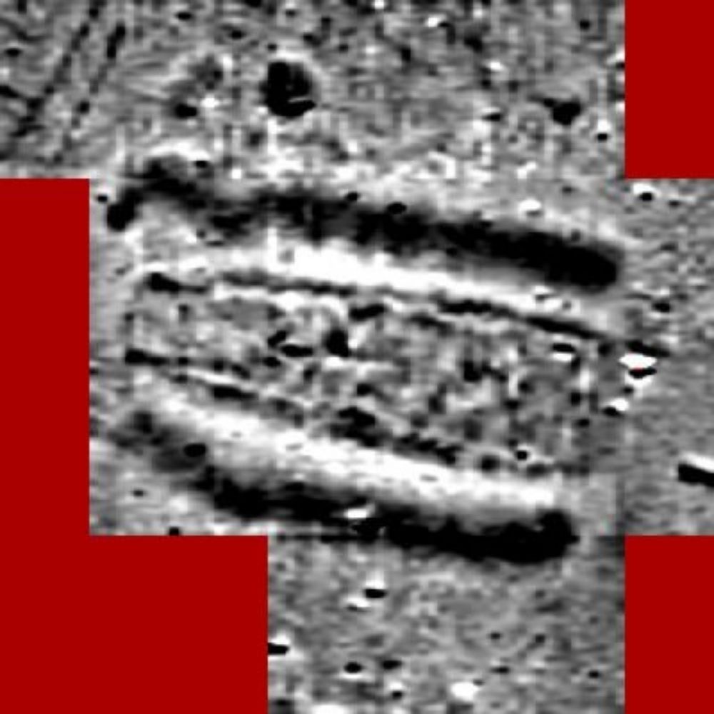
2/7 The cropmarks show the infilled flanking ditches of a long barrow. They are almost parallel, but taper slightly, and the barrow was probably about 35-45m in length. The LiDAR shows traces of a ploughed out mound.

October 4, 2025 at 2:31 PM
2/7 The cropmarks show the infilled flanking ditches of a long barrow. They are almost parallel, but taper slightly, and the barrow was probably about 35-45m in length. The LiDAR shows traces of a ploughed out mound.
9/9 A PDF of an article on the Warren Farm long barrow, and citation information, can be downloaded from wp.me/pgKiQE-c

Unrecognised as the longest long barrow in Hampshire? The Warren Farm long barrow at Morestead
by Michael Gill This article can be accessed / cited here: and is available for download as a PDF at the end of this article. Although long barrow discoveries are still being made, it is fair to sa…
wp.me
August 22, 2025 at 3:37 PM
9/9 A PDF of an article on the Warren Farm long barrow, and citation information, can be downloaded from wp.me/pgKiQE-c
8/9 If this monument really is so large, it is interesting to ask why it is located where it is. Circled on the map below, it is on the edge of only a sparse scatter of long barrows ...

August 22, 2025 at 3:37 PM
8/9 If this monument really is so large, it is interesting to ask why it is located where it is. Circled on the map below, it is on the edge of only a sparse scatter of long barrows ...
7/9 It is so long, it can also be compared with bank barrows, which are extremely long parallel sided mounds. In this case, it is probably not sufficiently regular to be included in this class ...

August 22, 2025 at 3:37 PM
7/9 It is so long, it can also be compared with bank barrows, which are extremely long parallel sided mounds. In this case, it is probably not sufficiently regular to be included in this class ...
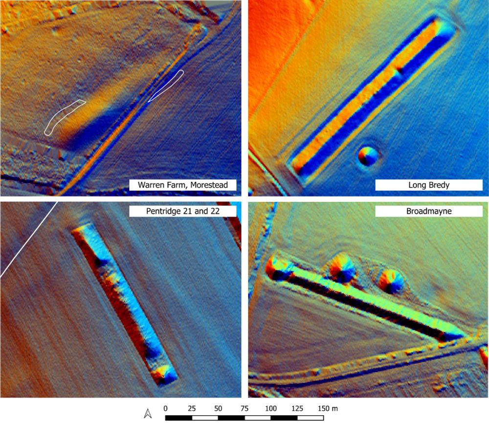
6/9 Its form can also be compared with other large Hampshire long barrows ...

August 22, 2025 at 3:37 PM
6/9 Its form can also be compared with other large Hampshire long barrows ...
5/9 If this #Neolithic long barrow really is 135m, how does it compare with other Hampshire long barrows? The chart shows just how much longer it is, an incredible 25m more than the next longest ...

August 22, 2025 at 3:37 PM
5/9 If this #Neolithic long barrow really is 135m, how does it compare with other Hampshire long barrows? The chart shows just how much longer it is, an incredible 25m more than the next longest ...
4/9 When the cropmark traces are overlaid onto the LiDAR, they perfectly flank the mound, appearing to confirm that the 'ridge' is actually an extension, or tail, to the mound ...

August 22, 2025 at 3:37 PM
4/9 When the cropmark traces are overlaid onto the LiDAR, they perfectly flank the mound, appearing to confirm that the 'ridge' is actually an extension, or tail, to the mound ...
3/9 However, recent imagery on Google Earth shows what appear to be two sections of ditch ...

August 22, 2025 at 3:37 PM
3/9 However, recent imagery on Google Earth shows what appear to be two sections of ditch ...
2/9 The Warren Farm long barrow is 5km south-east of Winchester and was recorded by RCHME as 60m in length, located on a 'narrow ridge'. LiDAR plots suggested this 'narrow ridge' might actually be an extension of the mound, but this was hard to prove. ...

August 22, 2025 at 3:37 PM
2/9 The Warren Farm long barrow is 5km south-east of Winchester and was recorded by RCHME as 60m in length, located on a 'narrow ridge'. LiDAR plots suggested this 'narrow ridge' might actually be an extension of the mound, but this was hard to prove. ...
Hugh Davies (2002, Fig 12) provides a handy schematic including these small 'outer' ditches (A and A') in his book 'Roads in Roman Britain'. (4/4) #Archaeology

August 14, 2025 at 8:46 PM
Hugh Davies (2002, Fig 12) provides a handy schematic including these small 'outer' ditches (A and A') in his book 'Roads in Roman Britain'. (4/4) #Archaeology
Ivan Margary (1973, 22) suggests such ditches mark out a 'road zone' for Roman roads, with the agger of the road built centrally between them. He describes two 'classes' of ditch separation, 84 feet and 62 feet. The Old Sarum example matches the former almost exactly (3/4)

August 14, 2025 at 8:46 PM
Ivan Margary (1973, 22) suggests such ditches mark out a 'road zone' for Roman roads, with the agger of the road built centrally between them. He describes two 'classes' of ditch separation, 84 feet and 62 feet. The Old Sarum example matches the former almost exactly (3/4)
They also appear on aerial photographs, allowing the distance between the ditches to be measured - approximately 26m (85 feet). How did these ditches relate to the road? (2/4)

August 14, 2025 at 8:46 PM
They also appear on aerial photographs, allowing the distance between the ditches to be measured - approximately 26m (85 feet). How did these ditches relate to the road? (2/4)
2/2 The map and gazetteer listing the sites numbered on the map can be viewed on archive org here: archive.org/details/Neol...
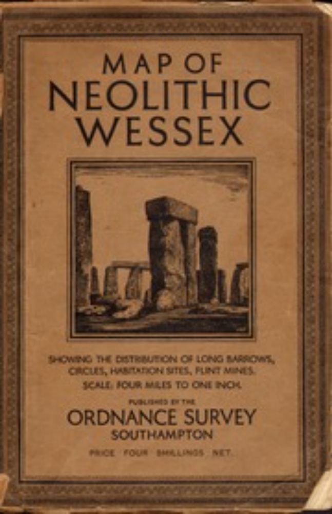
Neolithic Wessex Ordnance Survey 1932 Map : Ordnance Survey, UK : Free Download, Borrow, and Streaming : Internet Archive
Map showing the distribution of long barrows, circles, habitation sites, and flint mines in Wessex, Southern England, at a scale of four inches to one mile....
archive.org
May 26, 2025 at 10:59 AM
2/2 The map and gazetteer listing the sites numbered on the map can be viewed on archive org here: archive.org/details/Neol...