


Mike Flannigan
@mikeflannigan.bsky.social
fire guy, weather guy, researcher, professor and research chair.
Thompson Rivers University
Thompson Rivers University
Graph from a recent paper on widespread & intense surface air temperature is scary for many reasons including fire. Higher temperatures & more extreme heat will lead to more intense fires in many parts of the world largely due to drier fuels driven by increased vpd.
www.science.org/doi/10.1126/...
www.science.org/doi/10.1126/...

November 7, 2025 at 7:30 PM
Graph from a recent paper on widespread & intense surface air temperature is scary for many reasons including fire. Higher temperatures & more extreme heat will lead to more intense fires in many parts of the world largely due to drier fuels driven by increased vpd.
www.science.org/doi/10.1126/...
www.science.org/doi/10.1126/...
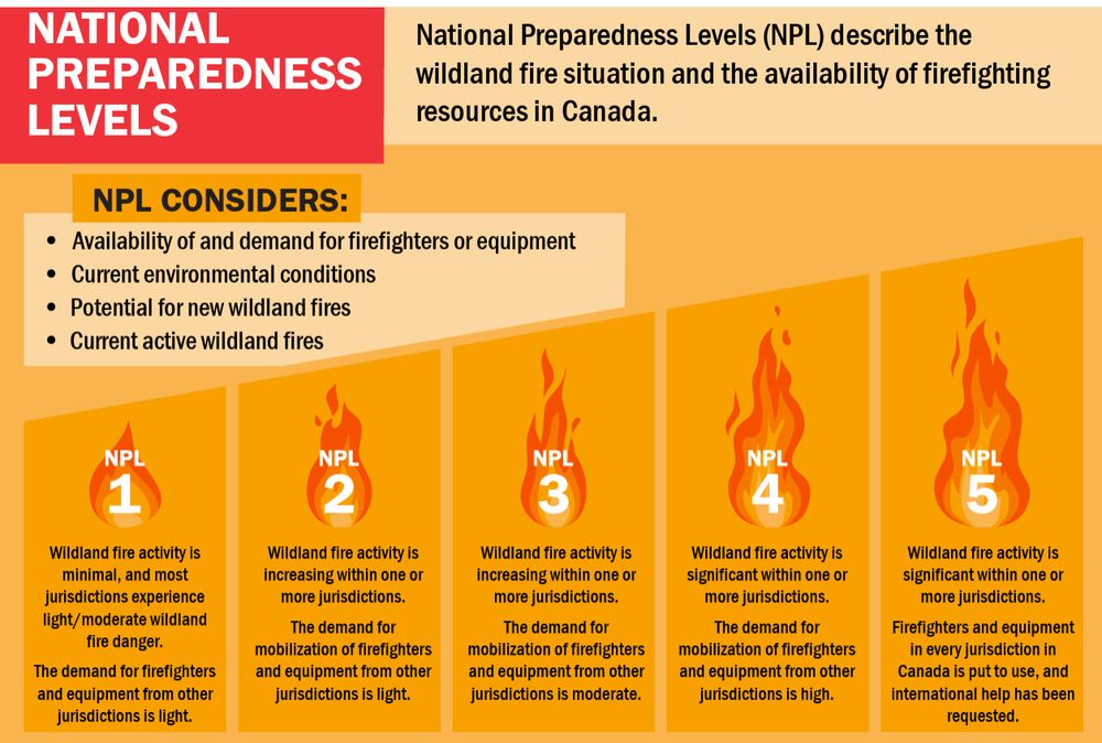
NPL5 in Canada means - Wildland fire activity is significant within one or more jurisdictions. Firefighters and equipment in every jurisdiction in Canada are in use & international help has been requested. Graph of the # of NPL5 days by year in Canada. There are not enough resources in recent years

October 31, 2025 at 7:16 PM
NPL5 in Canada means - Wildland fire activity is significant within one or more jurisdictions. Firefighters and equipment in every jurisdiction in Canada are in use & international help has been requested. Graph of the # of NPL5 days by year in Canada. There are not enough resources in recent years
New Perspective - Canada’s landscape fires spreading into uncharted territory
Canada clearly needs to do more. More to prevent & mitigate wildfires, more to increase our initial response capacity and capability to protect communities & critical infrastructure.
iopscience.iop.org/article/10.1...
Canada clearly needs to do more. More to prevent & mitigate wildfires, more to increase our initial response capacity and capability to protect communities & critical infrastructure.
iopscience.iop.org/article/10.1...

October 28, 2025 at 5:50 PM
New Perspective - Canada’s landscape fires spreading into uncharted territory
Canada clearly needs to do more. More to prevent & mitigate wildfires, more to increase our initial response capacity and capability to protect communities & critical infrastructure.
iopscience.iop.org/article/10.1...
Canada clearly needs to do more. More to prevent & mitigate wildfires, more to increase our initial response capacity and capability to protect communities & critical infrastructure.
iopscience.iop.org/article/10.1...
Some active fires in northern Alberta today. GOES-West geocolor loop below. Also, active fires in the Northwest Territories today (not shown in this loop).
September 24, 2025 at 8:51 PM
Some active fires in northern Alberta today. GOES-West geocolor loop below. Also, active fires in the Northwest Territories today (not shown in this loop).
🔥New paper - Comparative Analysis of Ensemble and Deterministic Models for Fire Weather Index (FWI) System Forecasting.
Ensemble forecasts for fire management decision-making include probabilistic fire growth modelling, long-term strategic planning etc.
journals.ametsoc.org/view/journal...
Ensemble forecasts for fire management decision-making include probabilistic fire growth modelling, long-term strategic planning etc.
journals.ametsoc.org/view/journal...

September 16, 2025 at 5:18 PM
🔥New paper - Comparative Analysis of Ensemble and Deterministic Models for Fire Weather Index (FWI) System Forecasting.
Ensemble forecasts for fire management decision-making include probabilistic fire growth modelling, long-term strategic planning etc.
journals.ametsoc.org/view/journal...
Ensemble forecasts for fire management decision-making include probabilistic fire growth modelling, long-term strategic planning etc.
journals.ametsoc.org/view/journal...
The 2025 BC fire season area burned (872k ha) has moved into 5th place with the recent fire activity. This means that the top 6 fire seasons have been since 2017 (records go back to 1950) Area burned-red bars (2017-2025 graph below) far exceeds the green bars (1950-2016). Climate change in action.


September 13, 2025 at 5:23 PM
The 2025 BC fire season area burned (872k ha) has moved into 5th place with the recent fire activity. This means that the top 6 fire seasons have been since 2017 (records go back to 1950) Area burned-red bars (2017-2025 graph below) far exceeds the green bars (1950-2016). Climate change in action.
New study in Nature on the Long-range PM2.5 pollution and health impacts from the 2023 Canadian wildfires
www.nature.com/articles/s41...
'We find that 354 million (277–421 million) people in North America and Europe were exposed to daily PM2.5 air pollution caused by Canadian wildfires in 2023'
www.nature.com/articles/s41...
'We find that 354 million (277–421 million) people in North America and Europe were exposed to daily PM2.5 air pollution caused by Canadian wildfires in 2023'

September 10, 2025 at 4:49 PM
New study in Nature on the Long-range PM2.5 pollution and health impacts from the 2023 Canadian wildfires
www.nature.com/articles/s41...
'We find that 354 million (277–421 million) people in North America and Europe were exposed to daily PM2.5 air pollution caused by Canadian wildfires in 2023'
www.nature.com/articles/s41...
'We find that 354 million (277–421 million) people in North America and Europe were exposed to daily PM2.5 air pollution caused by Canadian wildfires in 2023'
Double Yikes for BC wildfires
Lots of lightning this weekend in BC (& WA-OR-ID) after a very long hot & dry period. Fuels are receptive (Duff Moisture Code is high - means very dry fuels where ltg fires typically ignite). If the forecast holds, I expect 100-200 new fire starts during Sept. 6-9 in BC
Lots of lightning this weekend in BC (& WA-OR-ID) after a very long hot & dry period. Fuels are receptive (Duff Moisture Code is high - means very dry fuels where ltg fires typically ignite). If the forecast holds, I expect 100-200 new fire starts during Sept. 6-9 in BC


September 3, 2025 at 11:11 PM
Double Yikes for BC wildfires
Lots of lightning this weekend in BC (& WA-OR-ID) after a very long hot & dry period. Fuels are receptive (Duff Moisture Code is high - means very dry fuels where ltg fires typically ignite). If the forecast holds, I expect 100-200 new fire starts during Sept. 6-9 in BC
Lots of lightning this weekend in BC (& WA-OR-ID) after a very long hot & dry period. Fuels are receptive (Duff Moisture Code is high - means very dry fuels where ltg fires typically ignite). If the forecast holds, I expect 100-200 new fire starts during Sept. 6-9 in BC
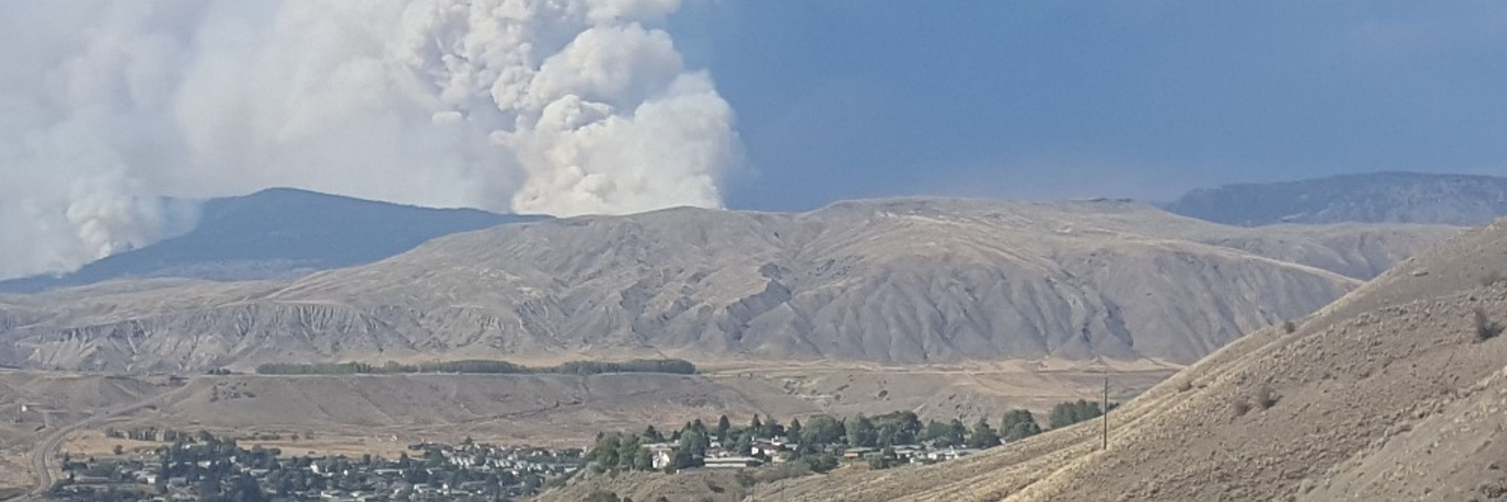
BC has 64 out of control wildfires burning and many of these are burning intensely. GOES-West 3.9 micron band (sensitive to high temperatures from wildfires) loop below showing active fires (white) and very active fires (red)
September 3, 2025 at 2:29 AM
BC has 64 out of control wildfires burning and many of these are burning intensely. GOES-West 3.9 micron band (sensitive to high temperatures from wildfires) loop below showing active fires (white) and very active fires (red)
Numerous large and active fires in central BC producing large smoke flumes. GOES- West geocolor below.
September 3, 2025 at 2:23 AM
Numerous large and active fires in central BC producing large smoke flumes. GOES- West geocolor below.
Some late fire season fires in the Yukon. GOES-West geocolor loop below.
September 2, 2025 at 3:57 AM
Some late fire season fires in the Yukon. GOES-West geocolor loop below.
Lots of fire in BC today - 140 active fires with 58 out of control. Some lightning today and tomorrow but possibly lots of lightning next Friday - Saturday in BC - Pacific NW. This would be after another hot -dry week means forest fuels would be very receptive to lightning strikes (ECMWF ltg map)


August 31, 2025 at 6:39 PM
Lots of fire in BC today - 140 active fires with 58 out of control. Some lightning today and tomorrow but possibly lots of lightning next Friday - Saturday in BC - Pacific NW. This would be after another hot -dry week means forest fuels would be very receptive to lightning strikes (ECMWF ltg map)
A double whammy - a smoke front followed by a cold front in NWT. Lots of very active fires in the NWT producing lots of smoke - GOES-West geocolor loop below. Expect significant growth on fires today as winds increase ahead of the fire and then shifts directions so that the flank becomes the head
August 30, 2025 at 5:19 PM
A double whammy - a smoke front followed by a cold front in NWT. Lots of very active fires in the NWT producing lots of smoke - GOES-West geocolor loop below. Expect significant growth on fires today as winds increase ahead of the fire and then shifts directions so that the flank becomes the head

August 29, 2025 at 8:22 PM
Yikes! No rain for BC for 15 days (WA -OR - CA as well) - a little exaggeration but not much. 15 day ECMWF - Quantitative Precipitation Forecast (QPF) for next 15 days shows little or no rain for BC. Our fuels are dry already and they will be even more receptive to lightning/human-caused fires.

August 28, 2025 at 10:12 PM
Yikes! No rain for BC for 15 days (WA -OR - CA as well) - a little exaggeration but not much. 15 day ECMWF - Quantitative Precipitation Forecast (QPF) for next 15 days shows little or no rain for BC. Our fuels are dry already and they will be even more receptive to lightning/human-caused fires.
Active fires burned through the night in central BC due to drought (traditional and flash -- associated with a strong blocking upper ridge). Smoke from these fires evident in the GOES-West geocolor loop. Potential for more fire starts today and for the development of Pyrocbs (fire generated tstms)
August 28, 2025 at 3:33 PM
Active fires burned through the night in central BC due to drought (traditional and flash -- associated with a strong blocking upper ridge). Smoke from these fires evident in the GOES-West geocolor loop. Potential for more fire starts today and for the development of Pyrocbs (fire generated tstms)
Pyrocb (fire generated thunderstorm) on the #GarnetFire on the GOES-West geocolor loop below. Expect rapid growth.
August 27, 2025 at 11:02 PM
Pyrocb (fire generated thunderstorm) on the #GarnetFire on the GOES-West geocolor loop below. Expect rapid growth.
Lots of active fires in the NWT this evening. Some pyrocu to the right of the gold line. Notice the south winds near the surface but as the column rises the winds shift to westerly
August 27, 2025 at 1:51 AM
Lots of active fires in the NWT this evening. Some pyrocu to the right of the gold line. Notice the south winds near the surface but as the column rises the winds shift to westerly
Canada has been at National Preparedness Level (NPL)5 for over 77% of the days in the 2025 fire season. NPL5 (highest level - see chart below). Problem - US is at NPL4 & record-breaking season in Europe so where are the extra resources - southern hemisphere.
Clearly, we do not have enough resources.
Clearly, we do not have enough resources.

August 25, 2025 at 4:45 PM
Canada has been at National Preparedness Level (NPL)5 for over 77% of the days in the 2025 fire season. NPL5 (highest level - see chart below). Problem - US is at NPL4 & record-breaking season in Europe so where are the extra resources - southern hemisphere.
Clearly, we do not have enough resources.
Clearly, we do not have enough resources.
Firms has a great tool for measuring fires
firms.modaps.eosdis.nasa.gov/map/#m:advan...
shows the #DollarFire at over 30,000 ac but an overestimate and I did not use the GOES hot spots as it might be picking up the heat from the plume
firms.modaps.eosdis.nasa.gov/map/#m:advan...
shows the #DollarFire at over 30,000 ac but an overestimate and I did not use the GOES hot spots as it might be picking up the heat from the plume

August 22, 2025 at 10:54 PM
Firms has a great tool for measuring fires
firms.modaps.eosdis.nasa.gov/map/#m:advan...
shows the #DollarFire at over 30,000 ac but an overestimate and I did not use the GOES hot spots as it might be picking up the heat from the plume
firms.modaps.eosdis.nasa.gov/map/#m:advan...
shows the #DollarFire at over 30,000 ac but an overestimate and I did not use the GOES hot spots as it might be picking up the heat from the plume
Here is the GOES-West geocolor loop - last I saw the #DollarFire was listed at 600 acres
wfca.com/fire-map/wyo...
expect it is several thousand acres now
wfca.com/fire-map/wyo...
expect it is several thousand acres now
August 22, 2025 at 10:13 PM
Here is the GOES-West geocolor loop - last I saw the #DollarFire was listed at 600 acres
wfca.com/fire-map/wyo...
expect it is several thousand acres now
wfca.com/fire-map/wyo...
expect it is several thousand acres now
Rapidly growing fire El Dorado county California- Coyote Fire.
GOES-West geocolor loop below. Cal Fire has it listed at 400 acres but the loop suggests it is larger than that.
www.fire.ca.gov/incidents/2025
GOES-West geocolor loop below. Cal Fire has it listed at 400 acres but the loop suggests it is larger than that.
www.fire.ca.gov/incidents/2025
August 21, 2025 at 2:19 AM
Rapidly growing fire El Dorado county California- Coyote Fire.
GOES-West geocolor loop below. Cal Fire has it listed at 400 acres but the loop suggests it is larger than that.
www.fire.ca.gov/incidents/2025
GOES-West geocolor loop below. Cal Fire has it listed at 400 acres but the loop suggests it is larger than that.
www.fire.ca.gov/incidents/2025
An update - looks like the Long Lake fire in Nova Scotia will experience strong winds associated with Hurricane Erin this weekend but no rain. The Kingston fire in Newfoundland might catch a shower but will likely miss the rain. However, it will definitely see the strong winds with Erin.

August 20, 2025 at 10:35 PM
An update - looks like the Long Lake fire in Nova Scotia will experience strong winds associated with Hurricane Erin this weekend but no rain. The Kingston fire in Newfoundland might catch a shower but will likely miss the rain. However, it will definitely see the strong winds with Erin.
The heat is coming to BC. An upper ridge will bring 7-10 days of hot dry weather (ECMWF 500 mb height anomaly map below). Forecast for Kamloops below with 6+ days 30C or higher. Fortunately, it does not look like much lightning activity until the ridge breakdown - this is a classic fire situation


August 20, 2025 at 8:53 PM
The heat is coming to BC. An upper ridge will bring 7-10 days of hot dry weather (ECMWF 500 mb height anomaly map below). Forecast for Kamloops below with 6+ days 30C or higher. Fortunately, it does not look like much lightning activity until the ridge breakdown - this is a classic fire situation
Fire and Hurricanes? Yes, a long way off but keep a watch on Erin as it moves NE with the prec. staying offshore but the wind field could influence fires in Nova Scotia and Newfoundland. ECMWF loop below Tropical systems impacting fires has happened in Europe (Opheila 2017) and Australia.
August 16, 2025 at 7:07 PM
Fire and Hurricanes? Yes, a long way off but keep a watch on Erin as it moves NE with the prec. staying offshore but the wind field could influence fires in Nova Scotia and Newfoundland. ECMWF loop below Tropical systems impacting fires has happened in Europe (Opheila 2017) and Australia.