

Michele Torresani
@micheletorresani.bsky.social
Vegetation, Forests, Biodiversity, Spatial ecology, Remote Sensing and climbing. Assistant professor at the Free University of Bolzano-Bozen
https://scholar.google.com/citations?user=A6LNYOYAAAAJ&hl=it&oi=ao
https://scholar.google.com/citations?user=A6LNYOYAAAAJ&hl=it&oi=ao
Pinned


New paper out! 🤘
Can we estimate forest biodiversity using spaceborne #EnMAP data? 🛰️
Turns out, yes — spectral heterogeneity from EnMAP can estimate tree species diversity in Alpine forests 🌲🌳🏔️
Especially in the NIR region, with area-weighted pixels and canopy cover > 70%.
🔓 lnkd.in/eWKGeGfs
Can we estimate forest biodiversity using spaceborne #EnMAP data? 🛰️
Turns out, yes — spectral heterogeneity from EnMAP can estimate tree species diversity in Alpine forests 🌲🌳🏔️
Especially in the NIR region, with area-weighted pixels and canopy cover > 70%.
🔓 lnkd.in/eWKGeGfs
October 30, 2025 at 7:55 AM
New paper out! 🤘
Can we estimate forest biodiversity using spaceborne #EnMAP data? 🛰️
Turns out, yes — spectral heterogeneity from EnMAP can estimate tree species diversity in Alpine forests 🌲🌳🏔️
Especially in the NIR region, with area-weighted pixels and canopy cover > 70%.
🔓 lnkd.in/eWKGeGfs
Can we estimate forest biodiversity using spaceborne #EnMAP data? 🛰️
Turns out, yes — spectral heterogeneity from EnMAP can estimate tree species diversity in Alpine forests 🌲🌳🏔️
Especially in the NIR region, with area-weighted pixels and canopy cover > 70%.
🔓 lnkd.in/eWKGeGfs
Glad to have contributed to this work!🤩

deadtrees.earth — An open-access and interactive database for centimeter-scale aerial imagery to uncover global tree mortality dynamics. www.sciencedirect.com/science/arti... Led by @cmosig.bsky.social

October 28, 2025 at 12:33 AM
Glad to have contributed to this work!🤩
🤩Proud to co-author a new paper led by Petra Pracná & Vítězslav Moudrý (CZU Prague): combining NASA’s ICESat-2 & GEDI LiDAR 🛰️data to build 90 m global DTMs 🌍—matching or surpassing Copernicus DEM accuracy in forests!🌲
🔗 www.sciencedirect.com/science/arti...
🔗 www.sciencedirect.com/science/arti...


October 16, 2025 at 7:38 PM
🤩Proud to co-author a new paper led by Petra Pracná & Vítězslav Moudrý (CZU Prague): combining NASA’s ICESat-2 & GEDI LiDAR 🛰️data to build 90 m global DTMs 🌍—matching or surpassing Copernicus DEM accuracy in forests!🌲
🔗 www.sciencedirect.com/science/arti...
🔗 www.sciencedirect.com/science/arti...
🚨 New research paper! 🌸🐝 UAV RGB + machine learning detect flowers as an indirect proxy for bee abundance—fast, scalable & eco-friendly! www.sciencedirect.com/science/arti...


August 15, 2025 at 4:50 PM
🚨 New research paper! 🌸🐝 UAV RGB + machine learning detect flowers as an indirect proxy for bee abundance—fast, scalable & eco-friendly! www.sciencedirect.com/science/arti...
#MAP-Rezia data collection is almost done! 🌺🌱 Thanks to @sonja, Angel & @gianmariabonari.bsky.social for completing botanical surveys between Stelvio & Swiss NP using the #ORCHAMP protocol. Now collecting remote sensing data✈️📡🛰️—will we detect the same biodiversity? Stay tuned for more…


August 13, 2025 at 3:00 PM
#MAP-Rezia data collection is almost done! 🌺🌱 Thanks to @sonja, Angel & @gianmariabonari.bsky.social for completing botanical surveys between Stelvio & Swiss NP using the #ORCHAMP protocol. Now collecting remote sensing data✈️📡🛰️—will we detect the same biodiversity? Stay tuned for more…
Look who visited our biodiversity plots! 🦊These pics come from our camera traps in Switzerland, part of the ORCHAMP network we’re using in the MAP-Rezia project to monitor biodiversity between Stelvio and the Swiss National Park.
Can we spot the same wild animals using Earth observation?🛰️Stay tuned!
Can we spot the same wild animals using Earth observation?🛰️Stay tuned!


July 23, 2025 at 8:23 PM
Look who visited our biodiversity plots! 🦊These pics come from our camera traps in Switzerland, part of the ORCHAMP network we’re using in the MAP-Rezia project to monitor biodiversity between Stelvio and the Swiss National Park.
Can we spot the same wild animals using Earth observation?🛰️Stay tuned!
Can we spot the same wild animals using Earth observation?🛰️Stay tuned!
Just 2 weeks after setting up plots & camera traps, we’ve got our first visitor! In #MAPRezia (Interreg Italia–Svizzera lnkd.in/eWv5FtPN) we map biodiversity in all forms—plants, trees, and wildlife—using field & remote sensing data. More to come this summer! 🌲🛰️

May 16, 2025 at 6:41 AM
Just 2 weeks after setting up plots & camera traps, we’ve got our first visitor! In #MAPRezia (Interreg Italia–Svizzera lnkd.in/eWv5FtPN) we map biodiversity in all forms—plants, trees, and wildlife—using field & remote sensing data. More to come this summer! 🌲🛰️
🌿 Field season has officially started for MAP-Rezia project!
Great to finally meet all partners in the forest instead of just on screen! We kicked off our data collection, discussed next steps, and set the ground for linking what we see on the ground🌲 with remote sensing data🛰️
Great to finally meet all partners in the forest instead of just on screen! We kicked off our data collection, discussed next steps, and set the ground for linking what we see on the ground🌲 with remote sensing data🛰️


May 8, 2025 at 3:21 PM
🌿 Field season has officially started for MAP-Rezia project!
Great to finally meet all partners in the forest instead of just on screen! We kicked off our data collection, discussed next steps, and set the ground for linking what we see on the ground🌲 with remote sensing data🛰️
Great to finally meet all partners in the forest instead of just on screen! We kicked off our data collection, discussed next steps, and set the ground for linking what we see on the ground🌲 with remote sensing data🛰️
Have you ever thought outside the box and created fuzzy maps? 🗺️
Our study, led by Emilia Pafumi, shows how fuzzy classification offers a more realistic approach to habitat mapping using high-res satellite imagery🛰️ www.sciencedirect.com/science/arti... #biodiversity #remotesensing #ecology #mapping
Our study, led by Emilia Pafumi, shows how fuzzy classification offers a more realistic approach to habitat mapping using high-res satellite imagery🛰️ www.sciencedirect.com/science/arti... #biodiversity #remotesensing #ecology #mapping

Fuzzy approaches provide improved spatial detection of coastal dune EU habitats
Mapping habitats on coastal dunes, crucial yet highly vulnerable ecosystems, requires objectivity and repeatability, which are still lacking in the im…
www.sciencedirect.com
March 4, 2025 at 9:31 AM
Have you ever thought outside the box and created fuzzy maps? 🗺️
Our study, led by Emilia Pafumi, shows how fuzzy classification offers a more realistic approach to habitat mapping using high-res satellite imagery🛰️ www.sciencedirect.com/science/arti... #biodiversity #remotesensing #ecology #mapping
Our study, led by Emilia Pafumi, shows how fuzzy classification offers a more realistic approach to habitat mapping using high-res satellite imagery🛰️ www.sciencedirect.com/science/arti... #biodiversity #remotesensing #ecology #mapping
Reposted by Michele Torresani

La guerra in #Ucraina ha un impatto drammatico anche sull’ambiente. @micheletorresani.bsky.social, ricercatore di #unibz, in collaborazione con #unibo, ha sviluppato un sistema di allerta precoce per stimare la perdita di superficie forestale. Leggi di più: www.unibzmagazine.it/en/magazine/...

L’AI in difesa delle foreste dell’Ucraina
Un sistema di allerta precoce basato sull’intelligenza artificiale rivela una massiccia perdita di foreste in Ucraina durante la guerra.
www.unibzmagazine.it
February 13, 2025 at 1:38 PM
La guerra in #Ucraina ha un impatto drammatico anche sull’ambiente. @micheletorresani.bsky.social, ricercatore di #unibz, in collaborazione con #unibo, ha sviluppato un sistema di allerta precoce per stimare la perdita di superficie forestale. Leggi di più: www.unibzmagazine.it/en/magazine/...
Just returned from the @esa.int #biospace25 conference hold in Frascati-Rome where I present my research on the link between different aspects of #biodiversity and vegetation height heterogeneity, assessed through remote sensing data 🌲 🛰️
If you missed my talk you can find it here: lnkd.in/eNxqeuMc
If you missed my talk you can find it here: lnkd.in/eNxqeuMc


February 13, 2025 at 9:59 AM
Just returned from the @esa.int #biospace25 conference hold in Frascati-Rome where I present my research on the link between different aspects of #biodiversity and vegetation height heterogeneity, assessed through remote sensing data 🌲 🛰️
If you missed my talk you can find it here: lnkd.in/eNxqeuMc
If you missed my talk you can find it here: lnkd.in/eNxqeuMc
🌿 Kick-off for the #MAP-Rezia Project! 🌿
Excited to launch MAP-Rezia (~€1M, #InterregItaliaSvizzera) to monitor biodiversity in #ParcoNazionaledelloStelvio & #SchweizerischerNationalpark! We'll use remote sensing to map ecosystems, track herbivores & assess forest scenarios under climate change. 🚀🌍
Excited to launch MAP-Rezia (~€1M, #InterregItaliaSvizzera) to monitor biodiversity in #ParcoNazionaledelloStelvio & #SchweizerischerNationalpark! We'll use remote sensing to map ecosystems, track herbivores & assess forest scenarios under climate change. 🚀🌍

February 9, 2025 at 11:18 AM
🌿 Kick-off for the #MAP-Rezia Project! 🌿
Excited to launch MAP-Rezia (~€1M, #InterregItaliaSvizzera) to monitor biodiversity in #ParcoNazionaledelloStelvio & #SchweizerischerNationalpark! We'll use remote sensing to map ecosystems, track herbivores & assess forest scenarios under climate change. 🚀🌍
Excited to launch MAP-Rezia (~€1M, #InterregItaliaSvizzera) to monitor biodiversity in #ParcoNazionaledelloStelvio & #SchweizerischerNationalpark! We'll use remote sensing to map ecosystems, track herbivores & assess forest scenarios under climate change. 🚀🌍
Reposted by Michele Torresani

iLand is the first forest landscape model to explicitly simulate forest microclimate. Why? Because microclimate effects propagate across scales and influence important processes such as decomposition, regeneration and bark beetle development. Read more in Braziunas et al. doi.org/10.1007/s109...
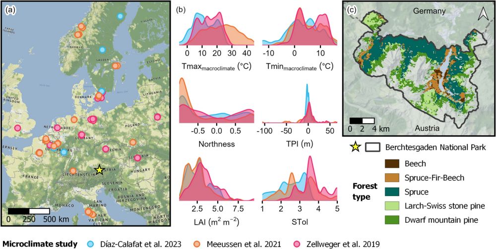
Microclimate temperature effects propagate across scales in forest ecosystems - Landscape Ecology
Context Forest canopies shape subcanopy environments, affecting biodiversity and ecosystem processes. Empirical forest microclimate studies are often restricted to local scales and short-term effects,...
doi.org
February 3, 2025 at 6:47 PM
iLand is the first forest landscape model to explicitly simulate forest microclimate. Why? Because microclimate effects propagate across scales and influence important processes such as decomposition, regeneration and bark beetle development. Read more in Braziunas et al. doi.org/10.1007/s109...
Reposted by Michele Torresani
Not all fieldwork pictures are equally breathtaking... The pictures I got from master student Sarane reading out
#microclimate sensor data from the cliffs of Freyr might just be what you needed to want to join MIREN's rock survey...
the3dlab.org/2025/02/03/s...
#microclimate sensor data from the cliffs of Freyr might just be what you needed to want to join MIREN's rock survey...
the3dlab.org/2025/02/03/s...

Sensors with a view
Not all fieldwork pictures are equally breathtaking. While part of our team waded through the muddy mud of De Driehoek – one of our university campus’s last patches of nature – an…
the3dlab.org
February 3, 2025 at 6:25 PM
Not all fieldwork pictures are equally breathtaking... The pictures I got from master student Sarane reading out
#microclimate sensor data from the cliffs of Freyr might just be what you needed to want to join MIREN's rock survey...
the3dlab.org/2025/02/03/s...
#microclimate sensor data from the cliffs of Freyr might just be what you needed to want to join MIREN's rock survey...
the3dlab.org/2025/02/03/s...
Have you ever thought using #LiDAR from mobile, terrestrial, and spaceborne #GEDI combined with optical and radar satellite data #Copernicus, to characterize #forest structural complexity?🌲🛰️ We did! Check out this paper, led by Patrick Kacic www.sciencedirect.com/science/arti...

Characterizing local forest structural complexity based on multi-platform and -sensor derived indicators
Global climate change, biodiversity decline, and increasing disturbances are challenging the health and resilience of forests. In this regard, forest …
www.sciencedirect.com
January 23, 2025 at 7:33 AM
Have you ever thought using #LiDAR from mobile, terrestrial, and spaceborne #GEDI combined with optical and radar satellite data #Copernicus, to characterize #forest structural complexity?🌲🛰️ We did! Check out this paper, led by Patrick Kacic www.sciencedirect.com/science/arti...
During the war in Ukraine, alongside the devastating loss of human lives, vast areas of forests have also been destroyed. In this new paper we estimated this forest loss using AI and remote sensing data🌲📡 #forest #war #Ukraine #remotesensing #Landsat
www.sciencedirect.com/science/arti...
www.sciencedirect.com/science/arti...

January 17, 2025 at 8:45 AM
During the war in Ukraine, alongside the devastating loss of human lives, vast areas of forests have also been destroyed. In this new paper we estimated this forest loss using AI and remote sensing data🌲📡 #forest #war #Ukraine #remotesensing #Landsat
www.sciencedirect.com/science/arti...
www.sciencedirect.com/science/arti...
Excited to share I’ve joined the Editorial Board of Community Ecology (Springer: link.springer.com/journal/42974)! 🌍📖
Looking forward to contributing to its mission and promoting impactful work, especially bridging ecological research with remote sensing technologies 🌲🛰️
Looking forward to contributing to its mission and promoting impactful work, especially bridging ecological research with remote sensing technologies 🌲🛰️

Community Ecology
Community Ecology, established by the merger of two ecological periodicals, Coenoses and Abstracta Botanica was launched in an effort to create a common ...
link.springer.com
January 16, 2025 at 10:47 AM
Excited to share I’ve joined the Editorial Board of Community Ecology (Springer: link.springer.com/journal/42974)! 🌍📖
Looking forward to contributing to its mission and promoting impactful work, especially bridging ecological research with remote sensing technologies 🌲🛰️
Looking forward to contributing to its mission and promoting impactful work, especially bridging ecological research with remote sensing technologies 🌲🛰️
Reposted by Michele Torresani
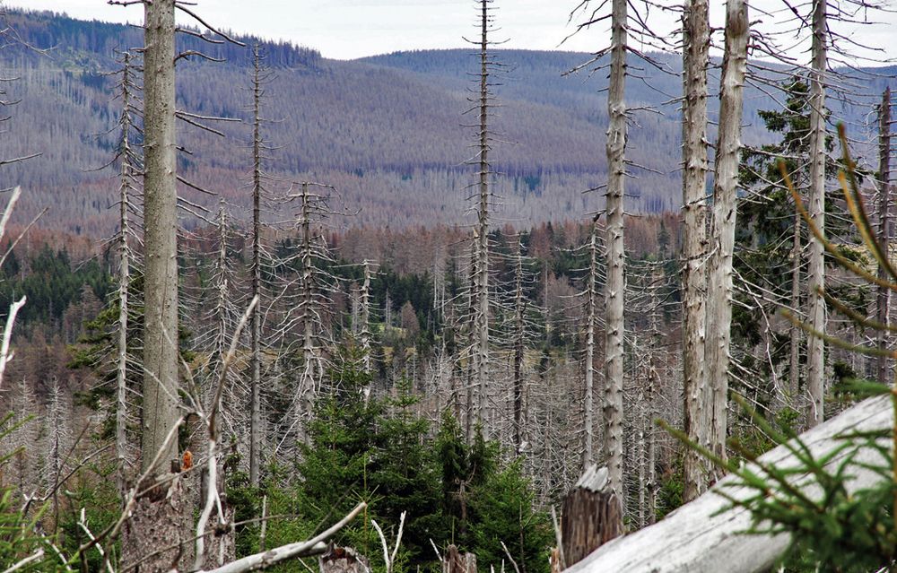
New paper! Forest disturbance through drought, windthrow, pest outbreaks and fire is increasing in Europe, driven by past planting decisions and climate change. In Germany alone, more than 500,000 ha of mostly Spruce died back in 2018-2022. Led by Anne Graser, we studied biodiversity responses...
December 20, 2024 at 12:46 PM
New paper! Forest disturbance through drought, windthrow, pest outbreaks and fire is increasing in Europe, driven by past planting decisions and climate change. In Germany alone, more than 500,000 ha of mostly Spruce died back in 2018-2022. Led by Anne Graser, we studied biodiversity responses...
I’m thinking of creating a new starter pack on "Remote sensing for forest biodiversity monitoring". I need at least seven others to join me—who’s interested?
January 7, 2025 at 11:57 AM
I’m thinking of creating a new starter pack on "Remote sensing for forest biodiversity monitoring". I need at least seven others to join me—who’s interested?
Reposted by Michele Torresani
📜More species, more trees: The role of tree packing in promoting forest productivity!
The effect of diversity on forest functioning is partly mediated by diversity-driven changes in stand density.
Published! Great work by @xaviermorin.bsky.social
doi.org/10.1111/1365...
The effect of diversity on forest functioning is partly mediated by diversity-driven changes in stand density.
Published! Great work by @xaviermorin.bsky.social
doi.org/10.1111/1365...

More species, more trees: The role of tree packing in promoting forest productivity
The effect of tree species richness on maximum stand density in forest plots had been suspected before, but it had hardly ever been taken into account in biodiversity–ecosystem–functioning studies. H....
doi.org
January 6, 2025 at 12:38 PM
📜More species, more trees: The role of tree packing in promoting forest productivity!
The effect of diversity on forest functioning is partly mediated by diversity-driven changes in stand density.
Published! Great work by @xaviermorin.bsky.social
doi.org/10.1111/1365...
The effect of diversity on forest functioning is partly mediated by diversity-driven changes in stand density.
Published! Great work by @xaviermorin.bsky.social
doi.org/10.1111/1365...
Reposted by Michele Torresani

Ready to learn how to use LiDAR for research in #forestry and natural resources using #R? This week I am sharing our 7-part series on Bluesky to help you get started! Share with anyone you know who wants to get started. Part 1 covers acquiring, & viewing LiDAR data! bit.ly/lidR-module1
January 6, 2025 at 3:33 PM
Ready to learn how to use LiDAR for research in #forestry and natural resources using #R? This week I am sharing our 7-part series on Bluesky to help you get started! Share with anyone you know who wants to get started. Part 1 covers acquiring, & viewing LiDAR data! bit.ly/lidR-module1
Reposted by Michele Torresani
Land-use change reduces bee diversity at local scales, but the impacts of agriculture and urbanisation differ at regional scales. Agriculture has more negative effects overall. onlinelibrary.wiley.com/doi/10.1111/... 🧪 🌏 🌐

January 6, 2025 at 10:25 AM
Land-use change reduces bee diversity at local scales, but the impacts of agriculture and urbanisation differ at regional scales. Agriculture has more negative effects overall. onlinelibrary.wiley.com/doi/10.1111/... 🧪 🌏 🌐
Reposted by Michele Torresani
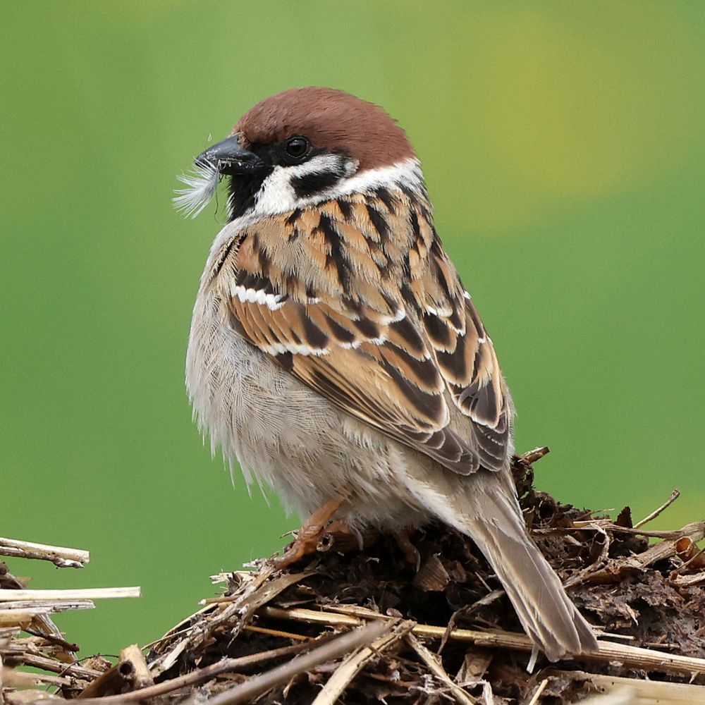
Remotely sensed spectral indicators of bird taxonomic, functional and phylogenetic diversity across Afrotropical urban and non-urban habitats | www.sciencedirect.co... | Ecological Indicators | #ornithology 🪶

Remotely sensed spectral indicators of bird taxonomic, functional and phylogenetic diversity across Afrotropical urban and non-urban habitats
Urban areas are quickly expanding around the world, promoting deep changes in biodiversity. However, certain biogeographic realms, like the Afrotropic…
www.sciencedirect.com
January 2, 2025 at 5:00 PM
Remotely sensed spectral indicators of bird taxonomic, functional and phylogenetic diversity across Afrotropical urban and non-urban habitats | www.sciencedirect.co... | Ecological Indicators | #ornithology 🪶
Reposted by Michele Torresani

Hi all, Happy New Year🍾
If you want to start 2025 learning about LiDAR technology and its practical applications in ecology using R, do not miss this course with @micheletorresani.bsky.social
There is ONLY 1 seat left: www.physalia-courses.org/courses-work...
If you want to start 2025 learning about LiDAR technology and its practical applications in ecology using R, do not miss this course with @micheletorresani.bsky.social
There is ONLY 1 seat left: www.physalia-courses.org/courses-work...

January 2, 2025 at 11:13 AM
Hi all, Happy New Year🍾
If you want to start 2025 learning about LiDAR technology and its practical applications in ecology using R, do not miss this course with @micheletorresani.bsky.social
There is ONLY 1 seat left: www.physalia-courses.org/courses-work...
If you want to start 2025 learning about LiDAR technology and its practical applications in ecology using R, do not miss this course with @micheletorresani.bsky.social
There is ONLY 1 seat left: www.physalia-courses.org/courses-work...
Reposted by Michele Torresani
In our recent paper led by M. Ny Aina Rakotoarivony, we showed that combining hyperspectral data with fine-resolution multispectral data significantly improves our ability to map the spatial distribution of invasive plants #NASA_SBG #cube_sats #fusion. www.sciencedirect.com/science/arti...

Mapping the spatial distribution of species using airborne and spaceborne imaging spectroscopy: A case study of invasive plants
Predicting the spatial distribution of invasive plants remains challenging because of the complex relationships between plant invasion, abiotic, and b…
www.sciencedirect.com
December 31, 2024 at 1:39 AM
In our recent paper led by M. Ny Aina Rakotoarivony, we showed that combining hyperspectral data with fine-resolution multispectral data significantly improves our ability to map the spatial distribution of invasive plants #NASA_SBG #cube_sats #fusion. www.sciencedirect.com/science/arti...