


Michael Seger
@michaelseger.bsky.social
Chief Meteorologist at 2NEWS Oklahoma. NWA Seal. Weather nerd. Photographer. Storm chaser. Nature is beautiful 💙
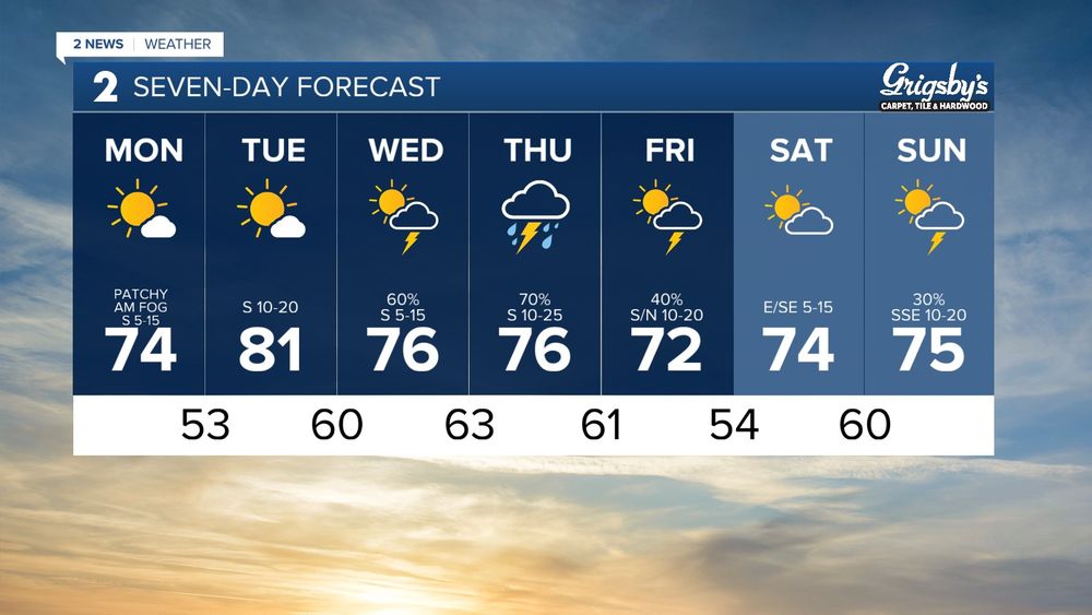
On-and-off chances of showers/storms into the weekend. Severe threat is thankfully low (marginal wind/hail). Localized flood threat
Monday's severe threat isn't a slam dunk, but parameters are high IF storms break the cap. Evening/night arrival
Storms more likely Tuesday. Severe possible.
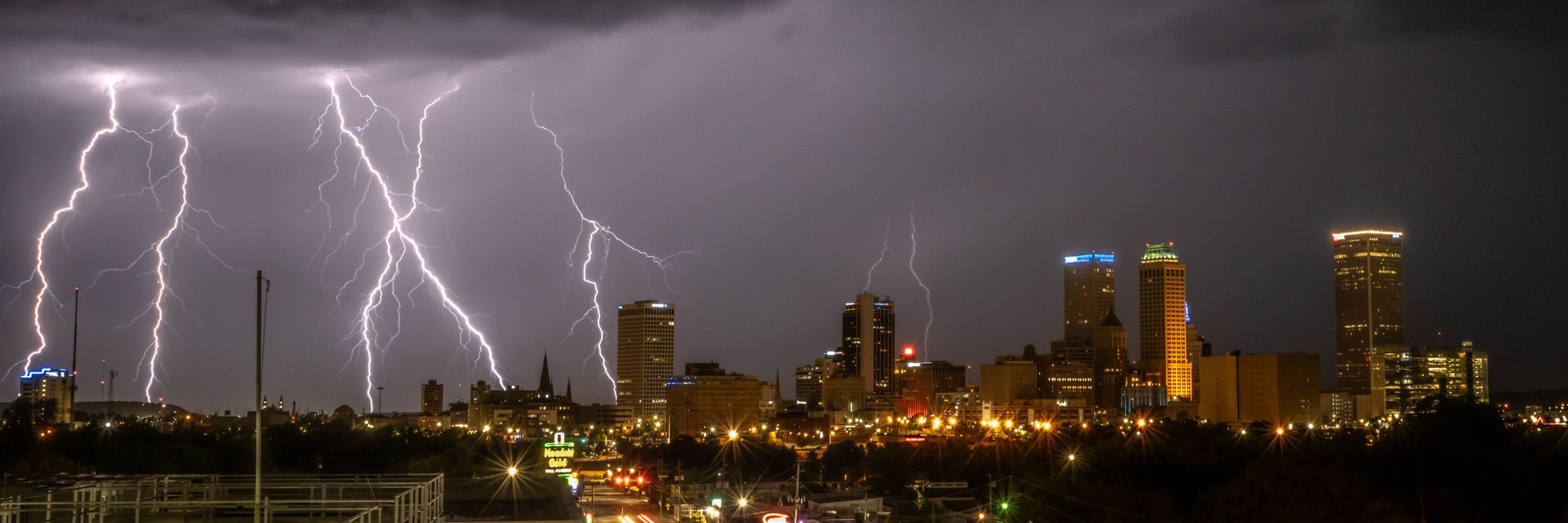
#okwx
Monday's severe threat isn't a slam dunk, but parameters are high IF storms break the cap. Evening/night arrival
Storms more likely Tuesday. Severe possible.
#okwx


April 25, 2025 at 2:25 AM
On-and-off chances of showers/storms into the weekend. Severe threat is thankfully low (marginal wind/hail). Localized flood threat
Monday's severe threat isn't a slam dunk, but parameters are high IF storms break the cap. Evening/night arrival
Storms more likely Tuesday. Severe possible.
#okwx
Monday's severe threat isn't a slam dunk, but parameters are high IF storms break the cap. Evening/night arrival
Storms more likely Tuesday. Severe possible.
#okwx
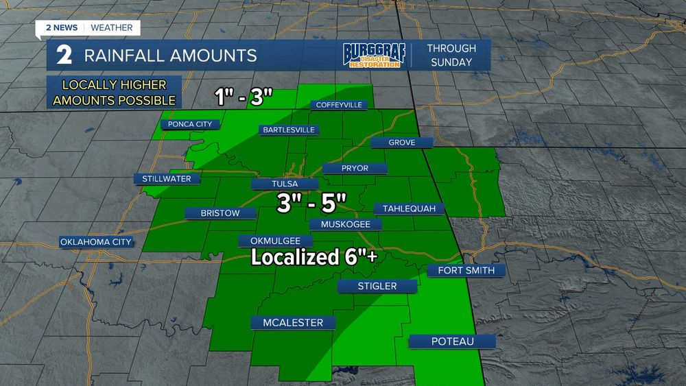
Chances for showers/storms will go up mid/late week. Severe weather can't be ruled out (it's April), but the widespread threat doesn't look very high
That said, we'll monitor any outflow boundaries and subtle small scale features that could bump up a localized severe threat
#Tulsa #okwx
That said, we'll monitor any outflow boundaries and subtle small scale features that could bump up a localized severe threat
#Tulsa #okwx

April 22, 2025 at 3:12 AM


April 22, 2025 at 2:59 AM
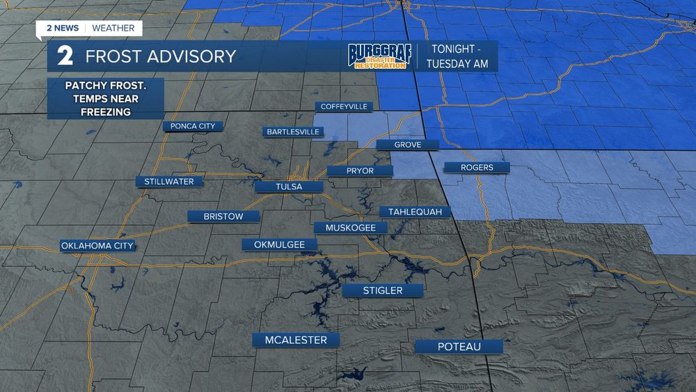
Be mindful, we may have low visibility in spots with patchy fog in Monday morning, but gonna be an AWESOME start to the week!! 😎
Storm chances go up by early Wednesday and stay into Friday. Locally heavy rain, probably some severe weather too, but nothing high-end
#Tulsa #okwx
Storm chances go up by early Wednesday and stay into Friday. Locally heavy rain, probably some severe weather too, but nothing high-end
#Tulsa #okwx

April 21, 2025 at 3:51 AM
FRI EVE - SAT AM: Severe storms likely. Localized flooding
SAT PM/Night: Severe storms mostly southeast, but all of us see rain and storms. Flood threat
EASTER SUNDAY AM: Storms chances remain, and may have a window for severe weather too if the system is slow to clear. Dry PM
SAT PM/Night: Severe storms mostly southeast, but all of us see rain and storms. Flood threat
EASTER SUNDAY AM: Storms chances remain, and may have a window for severe weather too if the system is slow to clear. Dry PM


April 18, 2025 at 3:11 AM
FRI EVE - SAT AM: Severe storms likely. Localized flooding
SAT PM/Night: Severe storms mostly southeast, but all of us see rain and storms. Flood threat
EASTER SUNDAY AM: Storms chances remain, and may have a window for severe weather too if the system is slow to clear. Dry PM
SAT PM/Night: Severe storms mostly southeast, but all of us see rain and storms. Flood threat
EASTER SUNDAY AM: Storms chances remain, and may have a window for severe weather too if the system is slow to clear. Dry PM
SUNDAY: Still monitoring timing. Highest chance for showers and storms will be in the morning with windy, cool, drier conditions in the afternoon
If the system is slower, there may be a window for severe weather in SE OK, but if it's faster, no need to worry
No severe weather is expected in Tulsa
If the system is slower, there may be a window for severe weather in SE OK, but if it's faster, no need to worry
No severe weather is expected in Tulsa

April 17, 2025 at 3:42 AM
SUNDAY: Still monitoring timing. Highest chance for showers and storms will be in the morning with windy, cool, drier conditions in the afternoon
If the system is slower, there may be a window for severe weather in SE OK, but if it's faster, no need to worry
No severe weather is expected in Tulsa
If the system is slower, there may be a window for severe weather in SE OK, but if it's faster, no need to worry
No severe weather is expected in Tulsa
SATURDAY: Cold front will continue to push south with chances of showers and storms for all of us, but the potential for a few severe storms will be highest near/south of the front. Right now it appears the front will end up south of I-44. Cooler temps north of the front.
#okwx
#okwx

April 17, 2025 at 3:39 AM
SATURDAY: Cold front will continue to push south with chances of showers and storms for all of us, but the potential for a few severe storms will be highest near/south of the front. Right now it appears the front will end up south of I-44. Cooler temps north of the front.
#okwx
#okwx

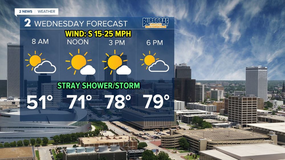
Despite the cool morning, expect a windy and warm Wednesday!! Highs ranging from mid 70s to low 80s. South wind gusts of 30-35 mph🌬️🌬️
I would not rule out the chance of a few isolated showers and storms Wednesday into Wednesday night. Most of us stay dry⚡️⚡️
#Tulsa #okwx #kswx
I would not rule out the chance of a few isolated showers and storms Wednesday into Wednesday night. Most of us stay dry⚡️⚡️
#Tulsa #okwx #kswx


April 16, 2025 at 2:53 AM
Severe storms likely Friday evening/night. 5pm - 7pm initiation. Wind and hail threat. Can't rule out a tornado or two
Saturday is dependent on where the front lines up. Near/south of the front = severe threat
Easter is all timing. Slow timing, severe is in play. Fast timing, severe stays east
Saturday is dependent on where the front lines up. Near/south of the front = severe threat
Easter is all timing. Slow timing, severe is in play. Fast timing, severe stays east


April 16, 2025 at 2:47 AM
Severe storms likely Friday evening/night. 5pm - 7pm initiation. Wind and hail threat. Can't rule out a tornado or two
Saturday is dependent on where the front lines up. Near/south of the front = severe threat
Easter is all timing. Slow timing, severe is in play. Fast timing, severe stays east
Saturday is dependent on where the front lines up. Near/south of the front = severe threat
Easter is all timing. Slow timing, severe is in play. Fast timing, severe stays east


April 10, 2025 at 3:13 AM
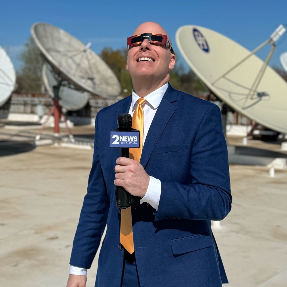
One year ago today, had the honor to cover the April 8, 2024 total solar eclipse from Russellville, Arkansas.
Totality is one of the most amazing and surreal experiences, and it’s hard to describe to those who haven’t witnessed it. Many find it surprisingly emotional as well.
#totalsolareclipse
Totality is one of the most amazing and surreal experiences, and it’s hard to describe to those who haven’t witnessed it. Many find it surprisingly emotional as well.
#totalsolareclipse
April 9, 2025 at 3:30 AM
One year ago today, had the honor to cover the April 8, 2024 total solar eclipse from Russellville, Arkansas.
Totality is one of the most amazing and surreal experiences, and it’s hard to describe to those who haven’t witnessed it. Many find it surprisingly emotional as well.
#totalsolareclipse
Totality is one of the most amazing and surreal experiences, and it’s hard to describe to those who haven’t witnessed it. Many find it surprisingly emotional as well.
#totalsolareclipse


A rare April snow??
Rain Saturday night may mix with or even change to snow by daybreak Sunday. IF a changeover occurs, a light coating may accumulate grassy surfaces before changing back to light rain. A LOT has to come together, but the chance is there!! Will be fun to monitor! ❄️❄️
#kswx #okwx
Rain Saturday night may mix with or even change to snow by daybreak Sunday. IF a changeover occurs, a light coating may accumulate grassy surfaces before changing back to light rain. A LOT has to come together, but the chance is there!! Will be fun to monitor! ❄️❄️
#kswx #okwx

April 5, 2025 at 4:13 AM
SATURDAY: A chilly and fairly wet weekend is ahead. Widespread rain and thunder Saturday morning will become more spotty to isolated in the afternoon with a higher chance southeast. Mid/upper 40s for temps. BRRRR!!
Flood potential remains E of HWY 69 where heavier rain has fallen
#okwx #Tulsa
Flood potential remains E of HWY 69 where heavier rain has fallen
#okwx #Tulsa

April 5, 2025 at 3:45 AM
Estimated path (based off radar) of this morning's tornado that tracked from Turley, through Owasso, to Limestone 🌪️
Keep in mind, this is only an estimated path, the actual damage path will be determined by NWS Tulsa during their damage survey
#okwx
Keep in mind, this is only an estimated path, the actual damage path will be determined by NWS Tulsa during their damage survey
#okwx

April 2, 2025 at 4:15 PM
Estimated path (based off radar) of this morning's tornado that tracked from Turley, through Owasso, to Limestone 🌪️
Keep in mind, this is only an estimated path, the actual damage path will be determined by NWS Tulsa during their damage survey
#okwx
Keep in mind, this is only an estimated path, the actual damage path will be determined by NWS Tulsa during their damage survey
#okwx
Need to watch the area near and north of I-44 tonight as a front is draped across the region. Severe risk could be slightly higher in that zone IF storms moving in from the west can take advantage of the shear along the front
Tornado watch in effect until 1am, but may need to be extended later
Tornado watch in effect until 1am, but may need to be extended later

March 30, 2025 at 3:46 AM
Need to watch the area near and north of I-44 tonight as a front is draped across the region. Severe risk could be slightly higher in that zone IF storms moving in from the west can take advantage of the shear along the front
Tornado watch in effect until 1am, but may need to be extended later
Tornado watch in effect until 1am, but may need to be extended later


Can you find yourself on a map? As we go into severe weather season, it’s always good to review our local geography and county names! We cover a small part of southeast KS and much of eastern OK. When tracking storms we use a map to track storms are and use county names often! Here’s a refresher!


March 28, 2025 at 11:32 PM
Can you find yourself on a map? As we go into severe weather season, it’s always good to review our local geography and county names! We cover a small part of southeast KS and much of eastern OK. When tracking storms we use a map to track storms are and use county names often! Here’s a refresher!
