


Matt Flournoy
@mflournoy.bsky.social
I study things that spin. OU/PSU meteorology alum | ⚽️🎹🍻😸🧋| pollinator lover, squash bug hater. He/him. Selfish: all opinions are my own.
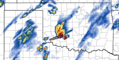
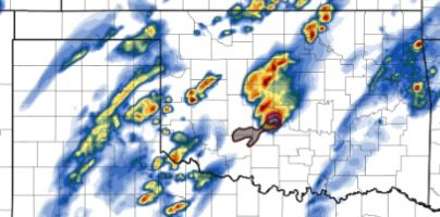
When the HRRR resolves a supercell-supercell merger.

April 18, 2025 at 7:13 PM
When the HRRR resolves a supercell-supercell merger.
What a High Risk corridor looks like at 23z. Woof.

April 2, 2025 at 11:02 PM
What a High Risk corridor looks like at 23z. Woof.
Searched “David Rose” for an appropriate GIF of my reaction to overnight CAM trends and, I mean… just pick one.
April 1, 2025 at 11:44 AM
Searched “David Rose” for an appropriate GIF of my reaction to overnight CAM trends and, I mean… just pick one.
The corridor across southern MN is terrifying. The tracks of these two prolific supercells are basically stacked on top of each other. Taylorsville, MS area just got hit hard, and they could take another direct hit in 40 minutes. Really scary situation unfolding.

March 15, 2025 at 7:14 PM
The corridor across southern MN is terrifying. The tracks of these two prolific supercells are basically stacked on top of each other. Taylorsville, MS area just got hit hard, and they could take another direct hit in 40 minutes. Really scary situation unfolding.
Probability of 2 or more tornadoes: >95%
Probability of 1 or more EF2–EF5 tornadoes: >95%
This is the third NOAA/SPC PDS tornado watch in history with both of these probabilities maxed out. Prolific and destructive tornado outbreak is imminent.
www.spc.noaa.gov/products/wat...
Probability of 1 or more EF2–EF5 tornadoes: >95%
This is the third NOAA/SPC PDS tornado watch in history with both of these probabilities maxed out. Prolific and destructive tornado outbreak is imminent.
www.spc.noaa.gov/products/wat...

March 15, 2025 at 3:45 PM
Probability of 2 or more tornadoes: >95%
Probability of 1 or more EF2–EF5 tornadoes: >95%
This is the third NOAA/SPC PDS tornado watch in history with both of these probabilities maxed out. Prolific and destructive tornado outbreak is imminent.
www.spc.noaa.gov/products/wat...
Probability of 1 or more EF2–EF5 tornadoes: >95%
This is the third NOAA/SPC PDS tornado watch in history with both of these probabilities maxed out. Prolific and destructive tornado outbreak is imminent.
www.spc.noaa.gov/products/wat...
Incredible coordination from the NWS as a significant (violent?) tornado bounces back and forth between the St. Louis and Paducah CWAs.

March 15, 2025 at 3:43 AM
Incredible coordination from the NWS as a significant (violent?) tornado bounces back and forth between the St. Louis and Paducah CWAs.
“Meteorological maestro” has a nice ring to it, and the quote has me rolling. And that’s from 12 posts… I’m impressed. 😂

December 4, 2024 at 4:27 AM
“Meteorological maestro” has a nice ring to it, and the quote has me rolling. And that’s from 12 posts… I’m impressed. 😂
Post a picture you took (no description) to bring some zen to the timeline.

November 16, 2024 at 9:22 PM
Post a picture you took (no description) to bring some zen to the timeline.
Low-level jet kicking in (LLJKI) in central OK along with some mid-level backing, yielding quite large low-level SRH and weak-ish mid-level storm-relative flow.

October 31, 2024 at 12:32 AM
Low-level jet kicking in (LLJKI) in central OK along with some mid-level backing, yielding quite large low-level SRH and weak-ish mid-level storm-relative flow.
If anything’s got a shot at posing a discrete threat to the OKC metro around 7p, seems like it’d come from this convergence zone. Updrafts are maturing in 90/58 air with an OFB lurking to their west. Maybe just me but this sub-watch, 1–4-hr forecast time is just so fascinating.
October 30, 2024 at 9:43 PM
If anything’s got a shot at posing a discrete threat to the OKC metro around 7p, seems like it’d come from this convergence zone. Updrafts are maturing in 90/58 air with an OFB lurking to their west. Maybe just me but this sub-watch, 1–4-hr forecast time is just so fascinating.