


Marcus Beyer
@meteomabe.bsky.social
#Forecaster and Hobby #Gardener | Works at German Weather Service: operational forecaster and supervisor | #tornado expert group
Especially interested in climatologies, #synoptics, #severeweather and #tornados.
Especially interested in climatologies, #synoptics, #severeweather and #tornados.
On my way to #ECSS2025 in Utrecht. Together with my colleague Kathrin Wapler I will present three posters about tornadoes. One covers the upcoming paper about tornado statistics in Germany. Looking forward to meet many experts on severe weather and friends!

November 16, 2025 at 2:54 PM
On my way to #ECSS2025 in Utrecht. Together with my colleague Kathrin Wapler I will present three posters about tornadoes. One covers the upcoming paper about tornado statistics in Germany. Looking forward to meet many experts on severe weather and friends!
I have never seen the desert sand in the atmosphere as clearly as I do today.

November 14, 2025 at 3:36 PM
I have never seen the desert sand in the atmosphere as clearly as I do today.
The models still show no sign of the first night frost in the Rhein-Main region until November 10. My frost indicator, the nasturtium, is still in good condition.


October 29, 2025 at 9:40 AM
The models still show no sign of the first night frost in the Rhein-Main region until November 10. My frost indicator, the nasturtium, is still in good condition.
Absoluteley stunning, mesmerizing...I have no words. Cannot imagine that I have ever seen such a symmetric Atlantic hurricane. Center pressure 892 hPa. It is really terrible that #Melissa is making landfall with such a strength! Image from tropical tidbits.

October 28, 2025 at 3:04 PM
Absoluteley stunning, mesmerizing...I have no words. Cannot imagine that I have ever seen such a symmetric Atlantic hurricane. Center pressure 892 hPa. It is really terrible that #Melissa is making landfall with such a strength! Image from tropical tidbits.
Further into the future, the path of #Melissa becomes very uncertain, so it is not clear if or how it may influence the weather in Europe over the coming weekend and next week.
October 27, 2025 at 7:51 PM
Further into the future, the path of #Melissa becomes very uncertain, so it is not clear if or how it may influence the weather in Europe over the coming weekend and next week.
Possible #tornado yesterday in #Sieberbach near Sulzbach/Murr (23.10.2025, 09:45 MESZ) . Radar product looks suspicious with rotation couplet in rel doppler winds.


October 24, 2025 at 8:47 AM
Possible #tornado yesterday in #Sieberbach near Sulzbach/Murr (23.10.2025, 09:45 MESZ) . Radar product looks suspicious with rotation couplet in rel doppler winds.

Here is another picture from my fotowebcam this evening!

October 9, 2025 at 8:55 PM
Here is another picture from my fotowebcam this evening!
Nice evening atmosphere

October 9, 2025 at 4:27 PM
Nice evening atmosphere
Very good, Bram! It was indeed 20.05.2006. That was the biggest summetime tornado outbreak since at least 2000 for Central Europa, with 16 confirmed tornadoes in the ESWD. Graphic shows wind and tornado reports of that day.
October 8, 2025 at 8:57 AM
Very good, Bram! It was indeed 20.05.2006. That was the biggest summetime tornado outbreak since at least 2000 for Central Europa, with 16 confirmed tornadoes in the ESWD. Graphic shows wind and tornado reports of that day.
Quite a difference in precipitation in Germany when looking at the accumulated totals over the last 30 days: below 20 mm north of the Harz and in parts of Berlin, but up to 250 mm in parts of Saarland.

October 7, 2025 at 2:52 AM
Quite a difference in precipitation in Germany when looking at the accumulated totals over the last 30 days: below 20 mm north of the Harz and in parts of Berlin, but up to 250 mm in parts of Saarland.
Does anybody remember that day? What #severeweather would you expect with that radar animation?
October 7, 2025 at 2:12 AM
Does anybody remember that day? What #severeweather would you expect with that radar animation?
Now the #tornado stripes seperated into strength. The second graphic shows weak (IF0 - IF1.5) vs. strong (IF2+) tornadoes. There is a disproportionately high maximum of strong tornadoes in the first 10 years compared to weak tornadoes. The average was 9 compared to 3 in the 10 years that followed.


October 5, 2025 at 10:42 PM
Now the #tornado stripes seperated into strength. The second graphic shows weak (IF0 - IF1.5) vs. strong (IF2+) tornadoes. There is a disproportionately high maximum of strong tornadoes in the first 10 years compared to weak tornadoes. The average was 9 compared to 3 in the 10 years that followed.
When looking into tornadic day this is becoming more obvious with a maximum of land tornados in 2004 instead of 2006 (waterspouts). Also the maxima in 2014 and 2016 are mainly due to waterspouts. A clear minimum is visible between 2017 and 2020, especially for land. 3/3

October 3, 2025 at 1:24 PM
When looking into tornadic day this is becoming more obvious with a maximum of land tornados in 2004 instead of 2006 (waterspouts). Also the maxima in 2014 and 2016 are mainly due to waterspouts. A clear minimum is visible between 2017 and 2020, especially for land. 3/3
We can now go more into detail by seperating each year into land and water events. Still a maximum can be seen for 2006 but one can also see, that this year was dominated by waterspouts. Also other relative maxima coming later have mainly their origin in waterspouts. 2/3

October 3, 2025 at 1:24 PM
We can now go more into detail by seperating each year into land and water events. Still a maximum can be seen for 2006 but one can also see, that this year was dominated by waterspouts. Also other relative maxima coming later have mainly their origin in waterspouts. 2/3
Your probably all know the #tornado stripes for Germany that I have posted several times. Starting at 2000 since with a robust dataset from then on. It shows a clear maxium for the years surounding the recors year 2006. #showyourstripes 1/3

October 3, 2025 at 1:24 PM
Your probably all know the #tornado stripes for Germany that I have posted several times. Starting at 2000 since with a robust dataset from then on. It shows a clear maxium for the years surounding the recors year 2006. #showyourstripes 1/3
The strongest wind gust with up to 200 km/h for the N islands are currently forecasted by the ECMWF model.
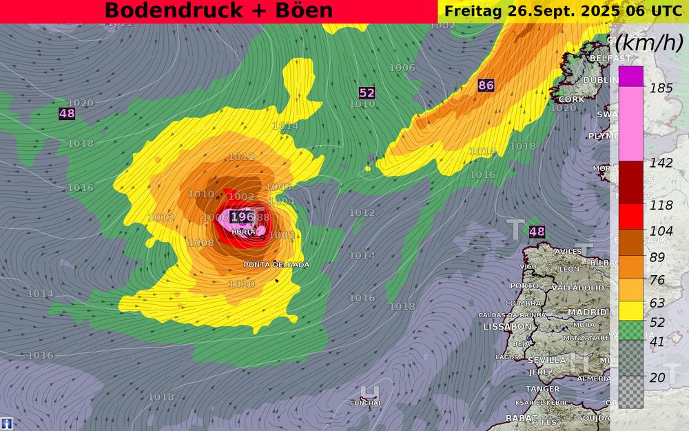
September 24, 2025 at 9:06 PM
The strongest wind gust with up to 200 km/h for the N islands are currently forecasted by the ECMWF model.
#Gabrielle will affect the #Azores beginning tomorrow afternoon until Friday. There a still some minor uncertainties about the exact track that grows when Gabrielle will approach the Iberian Peninsula. Next week #Humberto and another Invest may grow to #Hurrican strength, uncertainties are high.
September 24, 2025 at 8:51 PM
#Gabrielle will affect the #Azores beginning tomorrow afternoon until Friday. There a still some minor uncertainties about the exact track that grows when Gabrielle will approach the Iberian Peninsula. Next week #Humberto and another Invest may grow to #Hurrican strength, uncertainties are high.
This is how the most active part of the convective line near Sömmerda (close to Erfurt) currently looks like.

September 21, 2025 at 8:57 AM
This is how the most active part of the convective line near Sömmerda (close to Erfurt) currently looks like.
Unverständnis. :-( www.spiegel.de/auto/deutsch... #Deutschlandticket
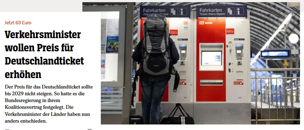
September 18, 2025 at 1:11 PM
Unverständnis. :-( www.spiegel.de/auto/deutsch... #Deutschlandticket
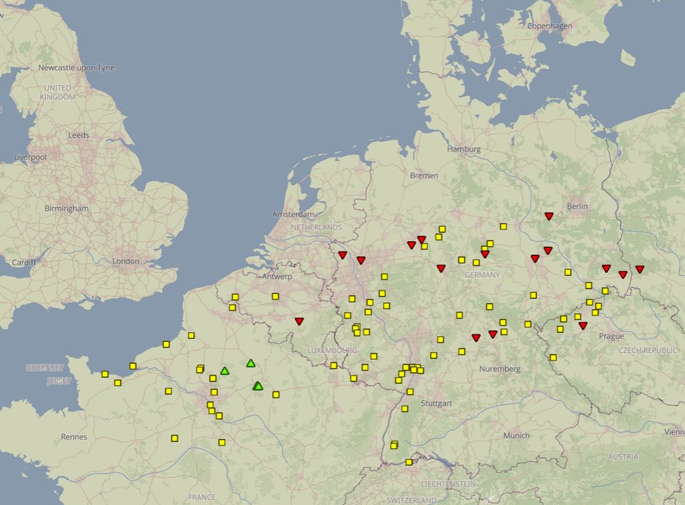
Maxima partly above 30 degree, potential for severe weather. That is sth that doesn't necessarily sound like beginning of the third decade of September. Maps look more like midsummer autumn.


September 16, 2025 at 12:01 PM
Maxima partly above 30 degree, potential for severe weather. That is sth that doesn't necessarily sound like beginning of the third decade of September. Maps look more like midsummer autumn.
