


mdsumner
@mdsumner.bsky.social
maxing the pixels to glow
meshes, R, Python, GDAL, virtual Zarr, coordinate systems, southern ocean research
hypertidy.org
meshes, R, Python, GDAL, virtual Zarr, coordinate systems, southern ocean research
hypertidy.org
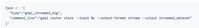
why tf does it suddenly work ...

October 21, 2025 at 11:44 AM
why tf does it suddenly work ...
HIGHLY recommended, I have some reading to do

October 11, 2025 at 12:14 AM
HIGHLY recommended, I have some reading to do
The other day my mum went away on holiday and later asked me to go check the stove at their house

September 28, 2025 at 12:52 PM
The other day my mum went away on holiday and later asked me to go check the stove at their house
my 14 year old question on SO was deleted finally, 33K views
I think I asked a handful of questions ever, and this one was never answered very helpfully I just learned it eventually through practice
I think I asked a handful of questions ever, and this one was never answered very helpfully I just learned it eventually through practice

September 18, 2025 at 12:44 AM
my 14 year old question on SO was deleted finally, 33K views
I think I asked a handful of questions ever, and this one was never answered very helpfully I just learned it eventually through practice
I think I asked a handful of questions ever, and this one was never answered very helpfully I just learned it eventually through practice
This guy has a gig tomorrow at Mona

September 14, 2025 at 12:31 AM
This guy has a gig tomorrow at Mona
Helluva list ... so happy to find it

August 30, 2025 at 9:15 AM
Helluva list ... so happy to find it
Found my old reading list, it extremely interesting and helpful to me. Wish I'd maintained it ... but restoring this into a partial list is going to help, a bit
Was actively keeping it 1997-2000, and there's helpful notes of earlier years and some of what was going on (where I was etc)
Was actively keeping it 1997-2000, and there's helpful notes of earlier years and some of what was going on (where I was etc)

August 30, 2025 at 9:01 AM
Found my old reading list, it extremely interesting and helpful to me. Wish I'd maintained it ... but restoring this into a partial list is going to help, a bit
Was actively keeping it 1997-2000, and there's helpful notes of earlier years and some of what was going on (where I was etc)
Was actively keeping it 1997-2000, and there's helpful notes of earlier years and some of what was going on (where I was etc)
fun with hillshade (of COP30 and ESRI imagery)

August 26, 2025 at 2:04 PM
fun with hillshade (of COP30 and ESRI imagery)
Fuck yeah, it's sunny and I can read and listen to Urge Overkill a little longer

August 2, 2025 at 3:15 AM
Fuck yeah, it's sunny and I can read and listen to Urge Overkill a little longer
still using buildvrt? no need (since GDAL 3.11), template in your sources as a comma-separated list and then this json description can be opened by any GDAL-enabled tool
August 1, 2025 at 10:57 PM
still using buildvrt? no need (since GDAL 3.11), template in your sources as a comma-separated list and then this json description can be opened by any GDAL-enabled tool
similar with the North
(annoying my plots are out of sync)
(annoying my plots are out of sync)

July 26, 2025 at 10:36 PM
similar with the North
(annoying my plots are out of sync)
(annoying my plots are out of sync)
not so bad across the suite of 3 (the palletized version only takes the last layer it seems) - I intend to make a bucket with this mean(, na.rm) version is that of interest?

July 26, 2025 at 10:31 PM
not so bad across the suite of 3 (the palletized version only takes the last layer it seems) - I intend to make a bucket with this mean(, na.rm) version is that of interest?
or, a more permanent problem now? I see better coverage with the mean of the netcdf layers (second image)


July 21, 2025 at 11:21 PM
or, a more permanent problem now? I see better coverage with the mean of the netcdf layers (second image)
Oh nice! Thanks for the pointer
Yml this paper, was referenced in old maptools for geog direction which I used elsewhere too
Sorry for image, I can't copy the link 🫠
Yml this paper, was referenced in old maptools for geog direction which I used elsewhere too
Sorry for image, I can't copy the link 🫠

July 12, 2025 at 11:27 AM
Oh nice! Thanks for the pointer
Yml this paper, was referenced in old maptools for geog direction which I used elsewhere too
Sorry for image, I can't copy the link 🫠
Yml this paper, was referenced in old maptools for geog direction which I used elsewhere too
Sorry for image, I can't copy the link 🫠
actually I lied, that was at low resolution, here is native GEBCO 2024
gist.github.com/mdsumner/daa...
gist.github.com/mdsumner/daa...

July 4, 2025 at 6:11 AM
actually I lied, that was at low resolution, here is native GEBCO 2024
gist.github.com/mdsumner/daa...
gist.github.com/mdsumner/daa...
extremely silly and niche, where in the world is the elevation 4326m

July 4, 2025 at 5:16 AM
extremely silly and niche, where in the world is the elevation 4326m


Emperor penguins!
(no context, this is somewhere, some time ... still working on the output)
all using #rstats {targets} and {gdalraster} and {mirai}
(no context, this is somewhere, some time ... still working on the output)
all using #rstats {targets} and {gdalraster} and {mirai}

June 17, 2025 at 9:19 PM
Emperor penguins!
(no context, this is somewhere, some time ... still working on the output)
all using #rstats {targets} and {gdalraster} and {mirai}
(no context, this is somewhere, some time ... still working on the output)
all using #rstats {targets} and {gdalraster} and {mirai}

zoomed in to prove it's the ship ha

June 17, 2025 at 2:01 PM
zoomed in to prove it's the ship ha
this is a much much better image from longer ago, this is the game to catch the windows together

June 17, 2025 at 1:52 PM
this is a much much better image from longer ago, this is the game to catch the windows together
I caught the Nuyina at Macquarie Island a few days ago in Sentinel imagery

June 17, 2025 at 1:51 PM
I caught the Nuyina at Macquarie Island a few days ago in Sentinel imagery