


Marcus Reynolds
@marcusreynold19.bsky.social
Storm Chaser, Photographer, Maker, Weather Enthusiast
One of the greatest plains lightning events in my memory.
4mi S of Arnett, OK 06-18-25 01:01Z
ISO50
F-10
0.4sec
(back bolt is stacked in from the previous photo in the burst)
4mi S of Arnett, OK 06-18-25 01:01Z
ISO50
F-10
0.4sec
(back bolt is stacked in from the previous photo in the burst)

October 16, 2025 at 4:03 AM
One of the greatest plains lightning events in my memory.
4mi S of Arnett, OK 06-18-25 01:01Z
ISO50
F-10
0.4sec
(back bolt is stacked in from the previous photo in the burst)
4mi S of Arnett, OK 06-18-25 01:01Z
ISO50
F-10
0.4sec
(back bolt is stacked in from the previous photo in the burst)
Pure kryptonite for my fat ass

December 24, 2024 at 1:04 AM
Pure kryptonite for my fat ass
5 Favorite chases of 2024:
1. April 26 - Minden, IA
2. May 23 - ElDorado, OK
3. May 21 - Greenfield, IA
4. August 15 - Mustang, OK
5. May 19- Custer City, OK
(Runner up is May 25- Mutual, OK with friends)
1. April 26 - Minden, IA
2. May 23 - ElDorado, OK
3. May 21 - Greenfield, IA
4. August 15 - Mustang, OK
5. May 19- Custer City, OK
(Runner up is May 25- Mutual, OK with friends)


December 7, 2024 at 1:18 AM
5 Favorite chases of 2024:
1. April 26 - Minden, IA
2. May 23 - ElDorado, OK
3. May 21 - Greenfield, IA
4. August 15 - Mustang, OK
5. May 19- Custer City, OK
(Runner up is May 25- Mutual, OK with friends)
1. April 26 - Minden, IA
2. May 23 - ElDorado, OK
3. May 21 - Greenfield, IA
4. August 15 - Mustang, OK
5. May 19- Custer City, OK
(Runner up is May 25- Mutual, OK with friends)
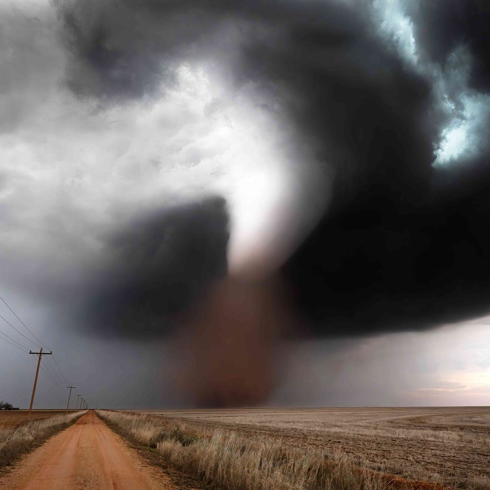
How about my first ever for #tornadotuesday, a stout EF-1 approaches my location near Edwards, MS on Dec 16th 2019

November 26, 2024 at 11:01 PM
How about my first ever for #tornadotuesday, a stout EF-1 approaches my location near Edwards, MS on Dec 16th 2019
Farther east into the afternoon thermodynamics may gradually improve, this may set the stage for a somewhat uncommon cold season small hail event for the southeast with weak LL shear and deep, moist thermos through the HGZ, a tornado or two cannot be ruled out given frontal vorticity and stretching.


November 26, 2024 at 10:53 PM
Farther east into the afternoon thermodynamics may gradually improve, this may set the stage for a somewhat uncommon cold season small hail event for the southeast with weak LL shear and deep, moist thermos through the HGZ, a tornado or two cannot be ruled out given frontal vorticity and stretching.
Thermodynamics will be... moist, with nearly saturated profiles and weak but sufficient lapse rates in place throughout.
November 26, 2024 at 10:53 PM
Thermodynamics will be... moist, with nearly saturated profiles and weak but sufficient lapse rates in place throughout.
The Right Entrance region weak lift and slight height falls which will enhance SW surface flow ahead of the cold front, the trailing end of a weak 850mb response will also be in place as a low deepens across the mid-atlantic. This will set the stage for long and unidirectional kinematic profiles.

November 26, 2024 at 10:53 PM
The Right Entrance region weak lift and slight height falls which will enhance SW surface flow ahead of the cold front, the trailing end of a weak 850mb response will also be in place as a low deepens across the mid-atlantic. This will set the stage for long and unidirectional kinematic profiles.
A departing jet streak and sagging cold front will leave the potential for some marginal severe weather across the deep south and eastern seaboard on the 28th.
November 26, 2024 at 10:53 PM
A departing jet streak and sagging cold front will leave the potential for some marginal severe weather across the deep south and eastern seaboard on the 28th.
I was maybe 2-3mi south of I-80 on a hillcrest for the council bluff wedge, got super lucky on my positioning but almost got hit by it as I was escaping to the interstate 😂
November 25, 2024 at 4:34 AM
I was maybe 2-3mi south of I-80 on a hillcrest for the council bluff wedge, got super lucky on my positioning but almost got hit by it as I was escaping to the interstate 😂
Blue dot being my position

November 25, 2024 at 4:09 AM
Blue dot being my position
Beefy Boi alert

November 23, 2024 at 6:35 PM
Beefy Boi alert
A cigar shaped tornado occludes out the back of the supercell while a new tornado tried to touch down over some bluffs.
Just on the Nebraska side of the border, near La Grange, WY.
06-23-23
Just on the Nebraska side of the border, near La Grange, WY.
06-23-23

November 22, 2024 at 4:57 PM
A cigar shaped tornado occludes out the back of the supercell while a new tornado tried to touch down over some bluffs.
Just on the Nebraska side of the border, near La Grange, WY.
06-23-23
Just on the Nebraska side of the border, near La Grange, WY.
06-23-23
Though line-mean midlevel shear is a bit lackluster, low level shear winds are backed almost perfectly perpendicular. This allows for efficient development of HSI vorticies which are able to be stretched by existing low level instability.


November 20, 2024 at 10:27 PM
Though line-mean midlevel shear is a bit lackluster, low level shear winds are backed almost perfectly perpendicular. This allows for efficient development of HSI vorticies which are able to be stretched by existing low level instability.
I try not to chase at night as much anymore for… reasons related to the second photo, but night tors absolutely carry a special aura.


November 20, 2024 at 6:28 PM
I try not to chase at night as much anymore for… reasons related to the second photo, but night tors absolutely carry a special aura.
About 15min before yesterday's post, the Yuma, CO tornado presented as a bright white, dead vertical, stovepipe. Unfortunately poor route choices prevented me from being closer.
08-08-23, Yuma, Colorado
08-08-23, Yuma, Colorado

November 19, 2024 at 3:31 PM
About 15min before yesterday's post, the Yuma, CO tornado presented as a bright white, dead vertical, stovepipe. Unfortunately poor route choices prevented me from being closer.
08-08-23, Yuma, Colorado
08-08-23, Yuma, Colorado
One of my all time favorite chases, this strong and slow moving, and meandering EF-3 tornado lasted 30min and took on many forms from a dusty wedge to a vertical stovepipe and this gnarly cone.
08-08-23, Yuma, Colorado.
08-08-23, Yuma, Colorado.
November 18, 2024 at 6:37 PM
One of my all time favorite chases, this strong and slow moving, and meandering EF-3 tornado lasted 30min and took on many forms from a dusty wedge to a vertical stovepipe and this gnarly cone.
08-08-23, Yuma, Colorado.
08-08-23, Yuma, Colorado.
This is all you need

November 18, 2024 at 5:30 AM
This is all you need
Trends in a stronger ML dry slot has presented the potential for a localized tornado outbreak across KS tomorrow.
Extreme Low level CAPE with strong shear and an tons of surface vorticity should present the potential for efficient tornado producers, I wouldn't rule out a few significant tornadoes.
Extreme Low level CAPE with strong shear and an tons of surface vorticity should present the potential for efficient tornado producers, I wouldn't rule out a few significant tornadoes.

November 18, 2024 at 4:25 AM
Trends in a stronger ML dry slot has presented the potential for a localized tornado outbreak across KS tomorrow.
Extreme Low level CAPE with strong shear and an tons of surface vorticity should present the potential for efficient tornado producers, I wouldn't rule out a few significant tornadoes.
Extreme Low level CAPE with strong shear and an tons of surface vorticity should present the potential for efficient tornado producers, I wouldn't rule out a few significant tornadoes.
From midnight tonight into mid-late morning tomorrow a severe weather shape will come together across the TX big country into SW and SC Oklahoma.

November 17, 2024 at 9:43 PM
From midnight tonight into mid-late morning tomorrow a severe weather shape will come together across the TX big country into SW and SC Oklahoma.
Hammon, OK is probably my top "Coulda Been" moment this year, I'm a sucker for the muted winter colors and the composition with the gnarled tree.

November 17, 2024 at 6:37 PM
Hammon, OK is probably my top "Coulda Been" moment this year, I'm a sucker for the muted winter colors and the composition with the gnarled tree.
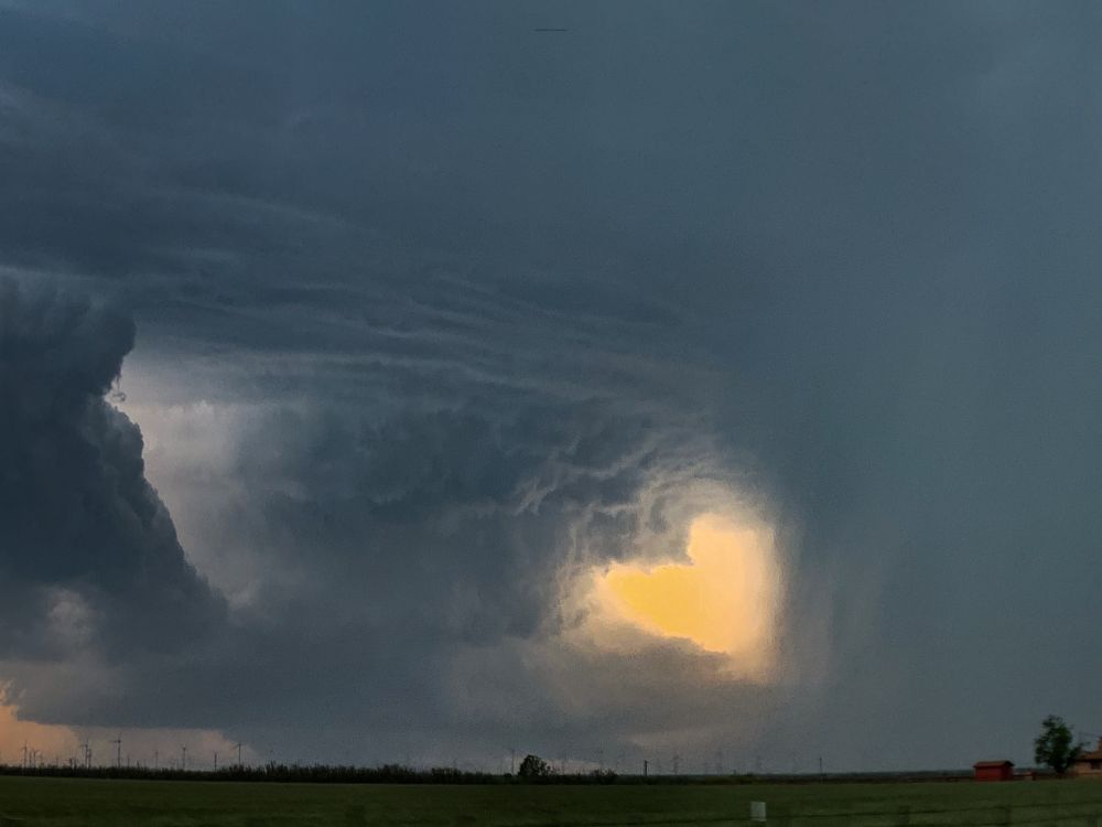
A curling twisted tree trunk of an updraft with a heart cut out for Twisted Thursday.
November 14, 2024 at 11:52 PM
A curling twisted tree trunk of an updraft with a heart cut out for Twisted Thursday.
I feel the need to supply additional evidence
November 13, 2024 at 9:29 PM
I feel the need to supply additional evidence
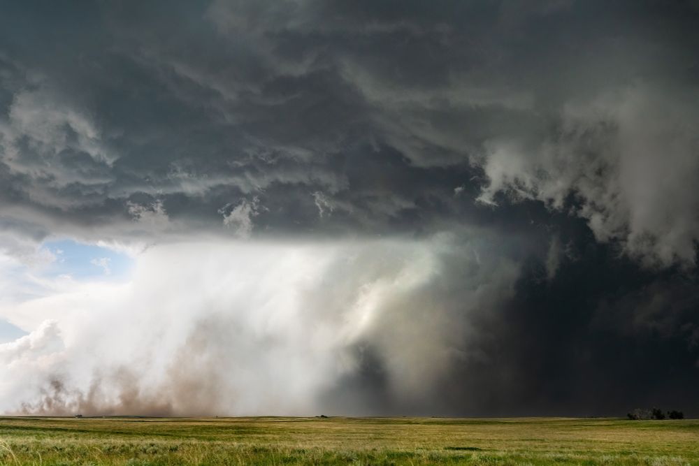
Windy Wednesday
150+mph winds on the Causeway to Boca Grande FL toss and shred trees.
Peak gust determined to be 163mph +-5mph through photogrammetry.
150+mph winds on the Causeway to Boca Grande FL toss and shred trees.
Peak gust determined to be 163mph +-5mph through photogrammetry.
November 13, 2024 at 7:04 PM
Windy Wednesday
150+mph winds on the Causeway to Boca Grande FL toss and shred trees.
Peak gust determined to be 163mph +-5mph through photogrammetry.
150+mph winds on the Causeway to Boca Grande FL toss and shred trees.
Peak gust determined to be 163mph +-5mph through photogrammetry.
Tornado Tuesday or somethin I guess

November 12, 2024 at 8:23 PM
Tornado Tuesday or somethin I guess
Southern Ontario pop off in November?

November 11, 2024 at 2:42 AM
Southern Ontario pop off in November?