


Historical maps
@maps.stefanbohacek.online.ap.brid.gy
A New Map of Maine. Published By S. Augustus Mitchell. N.E. corner of Market & 7th. Streets. Philada. 1848 Published in 1849. https://www.davidrumsey.com/luna/servlet/detail/RUMSEY~8~1~229717~5508170
#map #maps #historicalmaps
#map #maps #historicalmaps

December 10, 2025 at 12:38 PM
A New Map of Maine. Published By S. Augustus Mitchell. N.E. corner of Market & 7th. Streets. Philada. 1848 Published in 1849. https://www.davidrumsey.com/luna/servlet/detail/RUMSEY~8~1~229717~5508170
#map #maps #historicalmaps
#map #maps #historicalmaps
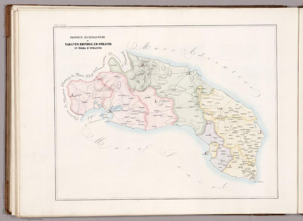
Tav. XXIII. Province ecclesiastiche di Taranto, Brindisi, ed Otranto in Terra d'Otranto. Published in 1859. https://www.davidrumsey.com/luna/servlet/detail/RUMSEY~8~1~328495~90097002
#map #maps #historicalmaps
#map #maps #historicalmaps
December 10, 2025 at 8:17 AM
Tav. XXIII. Province ecclesiastiche di Taranto, Brindisi, ed Otranto in Terra d'Otranto. Published in 1859. https://www.davidrumsey.com/luna/servlet/detail/RUMSEY~8~1~328495~90097002
#map #maps #historicalmaps
#map #maps #historicalmaps
Colton's New Hampshire. Published by G. W & C. B. Colton & Co., No. 172 William St. New York. Published in 1874. https://www.davidrumsey.com/luna/servlet/detail/RUMSEY~8~1~210006~5003829
#map #maps #historicalmaps
#map #maps #historicalmaps

December 10, 2025 at 4:01 AM
Colton's New Hampshire. Published by G. W & C. B. Colton & Co., No. 172 William St. New York. Published in 1874. https://www.davidrumsey.com/luna/servlet/detail/RUMSEY~8~1~210006~5003829
#map #maps #historicalmaps
#map #maps #historicalmaps
Oesterreich. C. Ungarische erbstaaten. III. Militaergrenze. e. Die Banat ... (To accompany) Atlas von Europa nebst den Kolonien : Zwolfte Lieferung. Leipzig bei Georg Joachim Goschen 1828. Published in 1830 […]
[Original post on stefanbohacek.online]
[Original post on stefanbohacek.online]

December 10, 2025 at 12:02 AM
Oesterreich. C. Ungarische erbstaaten. III. Militaergrenze. e. Die Banat ... (To accompany) Atlas von Europa nebst den Kolonien : Zwolfte Lieferung. Leipzig bei Georg Joachim Goschen 1828. Published in 1830 […]
[Original post on stefanbohacek.online]
[Original post on stefanbohacek.online]
Das Hertzogthum Limburg ist zu finden bey Joh. George Schreibern in Leipzig. (to accompany) Atlas selectus von allen Konigreichen und Landern der Welt ... Published in 1790. https://www.davidrumsey.com/luna/servlet/detail/RUMSEY~8~1~331724~90061697
#map #maps #historicalmaps
#map #maps #historicalmaps

December 9, 2025 at 9:10 PM
Das Hertzogthum Limburg ist zu finden bey Joh. George Schreibern in Leipzig. (to accompany) Atlas selectus von allen Konigreichen und Landern der Welt ... Published in 1790. https://www.davidrumsey.com/luna/servlet/detail/RUMSEY~8~1~331724~90061697
#map #maps #historicalmaps
#map #maps #historicalmaps
Karte vom Kaukasus ... Published in 1846. https://www.davidrumsey.com/luna/servlet/detail/RUMSEY~8~1~304159~90074752
#map #maps #historicalmaps
#map #maps #historicalmaps

December 9, 2025 at 4:13 PM
Karte vom Kaukasus ... Published in 1846. https://www.davidrumsey.com/luna/servlet/detail/RUMSEY~8~1~304159~90074752
#map #maps #historicalmaps
#map #maps #historicalmaps
Sheet 491. Lobenstein. Karte des Deutschen Reiches. Published in 1893. https://www.davidrumsey.com/luna/servlet/detail/RUMSEY~8~1~215352~5502225
#map #maps #historicalmaps
#map #maps #historicalmaps

December 9, 2025 at 1:47 PM
Sheet 491. Lobenstein. Karte des Deutschen Reiches. Published in 1893. https://www.davidrumsey.com/luna/servlet/detail/RUMSEY~8~1~215352~5502225
#map #maps #historicalmaps
#map #maps #historicalmaps
Carte comparee de la Gaule : divisee en 17 provinces romaines, de l'Italie septentrionale et d'une partie de la Grande Germanie. Publiee par J. Andriveau-Goujon, Rue du Bac, no. 21, Paris. 1861. Paris, Impie de Louis Antoine. (to accompany) Atlas […]
[Original post on stefanbohacek.online]
[Original post on stefanbohacek.online]

December 9, 2025 at 8:08 AM
Carte comparee de la Gaule : divisee en 17 provinces romaines, de l'Italie septentrionale et d'une partie de la Grande Germanie. Publiee par J. Andriveau-Goujon, Rue du Bac, no. 21, Paris. 1861. Paris, Impie de Louis Antoine. (to accompany) Atlas […]
[Original post on stefanbohacek.online]
[Original post on stefanbohacek.online]
Sheet 159. The Chilterns. Published in 1947. https://www.davidrumsey.com/luna/servlet/detail/RUMSEY~8~1~245507~5514697
#map #maps #historicalmaps
#map #maps #historicalmaps

December 9, 2025 at 4:13 AM
Sheet 159. The Chilterns. Published in 1947. https://www.davidrumsey.com/luna/servlet/detail/RUMSEY~8~1~245507~5514697
#map #maps #historicalmaps
#map #maps #historicalmaps
88 Doncaster (Hills) Published in 1900. https://www.davidrumsey.com/luna/servlet/detail/RUMSEY~8~1~270173~90045073
#map #maps #historicalmaps
#map #maps #historicalmaps

December 9, 2025 at 12:02 AM
88 Doncaster (Hills) Published in 1900. https://www.davidrumsey.com/luna/servlet/detail/RUMSEY~8~1~270173~90045073
#map #maps #historicalmaps
#map #maps #historicalmaps
Land Classification Map Of Part Of South Western Colorado, Atlas Sheet 61 (C.). Weyss, Lang & Herman Del. Expeditions of 1873 74 75 & 77 Under the Command of 1st. Lieut. Geo. M. Wheeler, Corps of Engineers, U.S. Army. U.S. Geographical Surveys West Of […]
[Original post on stefanbohacek.online]
[Original post on stefanbohacek.online]

December 8, 2025 at 8:04 PM
Land Classification Map Of Part Of South Western Colorado, Atlas Sheet 61 (C.). Weyss, Lang & Herman Del. Expeditions of 1873 74 75 & 77 Under the Command of 1st. Lieut. Geo. M. Wheeler, Corps of Engineers, U.S. Army. U.S. Geographical Surveys West Of […]
[Original post on stefanbohacek.online]
[Original post on stefanbohacek.online]
Germaniae, Galliae & Rhaetiae Pars. Stich, Druck & Verlag der geographischen Anstalt des Bibliographischen Instituts zu Hildburghausen. Gest. bei K. Kolbe von A. Heimburger. (In upper margin) Meyer's Zeitung Atlas. No. 112. (to accompany) Neuester […]
[Original post on stefanbohacek.online]
[Original post on stefanbohacek.online]

December 8, 2025 at 4:04 PM
Germaniae, Galliae & Rhaetiae Pars. Stich, Druck & Verlag der geographischen Anstalt des Bibliographischen Instituts zu Hildburghausen. Gest. bei K. Kolbe von A. Heimburger. (In upper margin) Meyer's Zeitung Atlas. No. 112. (to accompany) Neuester […]
[Original post on stefanbohacek.online]
[Original post on stefanbohacek.online]
Map of Lancaster County. (Philadelphia, Everts & Kirk, 1885) Published in 1885. https://www.davidrumsey.com/luna/servlet/detail/RUMSEY~8~1~29068~1130165
#map #maps #historicalmaps
#map #maps #historicalmaps

December 8, 2025 at 1:53 PM
Map of Lancaster County. (Philadelphia, Everts & Kirk, 1885) Published in 1885. https://www.davidrumsey.com/luna/servlet/detail/RUMSEY~8~1~29068~1130165
#map #maps #historicalmaps
#map #maps #historicalmaps
Sharpe's Corresponding Maps. Great Britain and Ireland. Engraved by J. Wilson Lowry. London - Published by Chapman and Hall, 186 Strand, 1847. Divisional Series. Published in 1849. https://www.davidrumsey.com/luna/servlet/detail/RUMSEY~8~1~37481~1210472
#map #maps #historicalmaps
#map #maps #historicalmaps

December 8, 2025 at 8:04 AM
Sharpe's Corresponding Maps. Great Britain and Ireland. Engraved by J. Wilson Lowry. London - Published by Chapman and Hall, 186 Strand, 1847. Divisional Series. Published in 1849. https://www.davidrumsey.com/luna/servlet/detail/RUMSEY~8~1~37481~1210472
#map #maps #historicalmaps
#map #maps #historicalmaps
40 Kirkby Stephen (Hills) Published in 1900. https://www.davidrumsey.com/luna/servlet/detail/RUMSEY~8~1~270087~90044476
#map #maps #historicalmaps
#map #maps #historicalmaps

December 8, 2025 at 4:06 AM
40 Kirkby Stephen (Hills) Published in 1900. https://www.davidrumsey.com/luna/servlet/detail/RUMSEY~8~1~270087~90044476
#map #maps #historicalmaps
#map #maps #historicalmaps
Rand McNally road map : Florida. Published in 1948. https://www.davidrumsey.com/luna/servlet/detail/RUMSEY~8~1~339405~90107543
#map #maps #historicalmaps
#map #maps #historicalmaps

December 8, 2025 at 12:10 AM
Rand McNally road map : Florida. Published in 1948. https://www.davidrumsey.com/luna/servlet/detail/RUMSEY~8~1~339405~90107543
#map #maps #historicalmaps
#map #maps #historicalmaps
Les Estats de Savoye et de Piemont (north central sheet). Published in 1695. https://www.davidrumsey.com/luna/servlet/detail/RUMSEY~8~1~288513~90060197
#map #maps #historicalmaps
#map #maps #historicalmaps

December 7, 2025 at 8:16 PM
Les Estats de Savoye et de Piemont (north central sheet). Published in 1695. https://www.davidrumsey.com/luna/servlet/detail/RUMSEY~8~1~288513~90060197
#map #maps #historicalmaps
#map #maps #historicalmaps
Plat no. 30 (San Francisco. (Compiled and published by Wm. P. Humphreys & Co., A.B. Holcombe, W.C. Kewen. Eng. by Worley & Bracher ... Phila, Pa. Printed by F. Bourquin ... Phila, Pa. 1876.) Published in 1876 […]
[Original post on stefanbohacek.online]
[Original post on stefanbohacek.online]

December 7, 2025 at 4:12 PM
Plat no. 30 (San Francisco. (Compiled and published by Wm. P. Humphreys & Co., A.B. Holcombe, W.C. Kewen. Eng. by Worley & Bracher ... Phila, Pa. Printed by F. Bourquin ... Phila, Pa. 1876.) Published in 1876 […]
[Original post on stefanbohacek.online]
[Original post on stefanbohacek.online]
The Dioecese of Leden. Leodiensis Dioec. (to accompany) Historia mundi : or Mercator's atlas. London Printed for Michaell Sparke, and are to be sowld in Greene Arboiure, 1637. Second edytion. Published in 1637 […]
[Original post on stefanbohacek.online]
[Original post on stefanbohacek.online]

December 7, 2025 at 12:14 PM
The Dioecese of Leden. Leodiensis Dioec. (to accompany) Historia mundi : or Mercator's atlas. London Printed for Michaell Sparke, and are to be sowld in Greene Arboiure, 1637. Second edytion. Published in 1637 […]
[Original post on stefanbohacek.online]
[Original post on stefanbohacek.online]
Deutschland's Eisenbahnen und Strassen-Netz. (Germany's Railway and Highway Network.) Published in 1875. https://www.davidrumsey.com/luna/servlet/detail/RUMSEY~8~1~277302~90050290
#map #maps #historicalmaps
#map #maps #historicalmaps

December 7, 2025 at 8:17 AM
Deutschland's Eisenbahnen und Strassen-Netz. (Germany's Railway and Highway Network.) Published in 1875. https://www.davidrumsey.com/luna/servlet/detail/RUMSEY~8~1~277302~90050290
#map #maps #historicalmaps
#map #maps #historicalmaps
Le Gouvernement General Du Duche De Bourgogne et Bresse .... Published in 1748. https://www.davidrumsey.com/luna/servlet/detail/RUMSEY~8~1~279534~90052628
#map #maps #historicalmaps
#map #maps #historicalmaps

December 7, 2025 at 4:19 AM
Le Gouvernement General Du Duche De Bourgogne et Bresse .... Published in 1748. https://www.davidrumsey.com/luna/servlet/detail/RUMSEY~8~1~279534~90052628
#map #maps #historicalmaps
#map #maps #historicalmaps
Frankreich. DEP: 1. Der Seine. 2. Der Seine und Oise. 3. Der Seine und marne. 41. Der Loiret. O.Hermann Lith. (to accompany) Atlas von Europa nebst den Kolonien : bearbeitet von W. E. A. v. Schlieben ... Leipzig bei Georg Joachim Goschen 1825. Published […]
[Original post on stefanbohacek.online]
[Original post on stefanbohacek.online]

December 7, 2025 at 12:07 AM
Frankreich. DEP: 1. Der Seine. 2. Der Seine und Oise. 3. Der Seine und marne. 41. Der Loiret. O.Hermann Lith. (to accompany) Atlas von Europa nebst den Kolonien : bearbeitet von W. E. A. v. Schlieben ... Leipzig bei Georg Joachim Goschen 1825. Published […]
[Original post on stefanbohacek.online]
[Original post on stefanbohacek.online]
India III. Bombay Presidency. J. & C. Walker sculpt. Published under the superintendence of the Society for the Diffusion of Useful Knowledge. London, published by Baldwin & Cradock, 47 Paternoster Row March 15th. 1832. (London: Chapman & Hall, 1844) […]
[Original post on stefanbohacek.online]
[Original post on stefanbohacek.online]

December 6, 2025 at 8:42 PM
India III. Bombay Presidency. J. & C. Walker sculpt. Published under the superintendence of the Society for the Diffusion of Useful Knowledge. London, published by Baldwin & Cradock, 47 Paternoster Row March 15th. 1832. (London: Chapman & Hall, 1844) […]
[Original post on stefanbohacek.online]
[Original post on stefanbohacek.online]
Grossbrittannien und Ireland. Published in 1847.https://www.davidrumsey.com/luna/servlet/detail/RUMSEY~8~1~297808~90069274
#map #maps #historicalmaps
#map #maps #historicalmaps

December 6, 2025 at 4:01 PM
Grossbrittannien und Ireland. Published in 1847.https://www.davidrumsey.com/luna/servlet/detail/RUMSEY~8~1~297808~90069274
#map #maps #historicalmaps
#map #maps #historicalmaps
London Sheet VII.71 Published in 1896.https://www.davidrumsey.com/luna/servlet/detail/RUMSEY~8~1~270997~90044152
#map #maps #historicalmaps
#map #maps #historicalmaps

December 6, 2025 at 12:01 PM
London Sheet VII.71 Published in 1896.https://www.davidrumsey.com/luna/servlet/detail/RUMSEY~8~1~270997~90044152
#map #maps #historicalmaps
#map #maps #historicalmaps