


Mapbox
@mapbox.com
Mapbox powers navigation for people, packages, and vehicles everywhere.
www.mapbox.com
www.mapbox.com
Tour all the maps we collect for the #30DayMapChallenge — featuring developer-built maps that push the boundaries of data, design, and interactivity. 🌍
buff.ly/GtCwSV0
#BuiltWithMapbox #MapDesign
buff.ly/GtCwSV0
#BuiltWithMapbox #MapDesign

November 11, 2025 at 6:00 PM
Tour all the maps we collect for the #30DayMapChallenge — featuring developer-built maps that push the boundaries of data, design, and interactivity. 🌍
buff.ly/GtCwSV0
#BuiltWithMapbox #MapDesign
buff.ly/GtCwSV0
#BuiltWithMapbox #MapDesign
#30DayMapChallenge Day 11 — Minimal map
Sometimes, you just need a really simple map. Today we’re giving a shout out to the Mapbox Documentation team for all their code examples and demos – including this super simple ‘Display a map on a webpage’ example: buff.ly/dgQbrBr
#BuiltWithMapbox #WebDev
Sometimes, you just need a really simple map. Today we’re giving a shout out to the Mapbox Documentation team for all their code examples and demos – including this super simple ‘Display a map on a webpage’ example: buff.ly/dgQbrBr
#BuiltWithMapbox #WebDev
November 11, 2025 at 4:05 PM
#30DayMapChallenge Day 11 — Minimal map
Sometimes, you just need a really simple map. Today we’re giving a shout out to the Mapbox Documentation team for all their code examples and demos – including this super simple ‘Display a map on a webpage’ example: buff.ly/dgQbrBr
#BuiltWithMapbox #WebDev
Sometimes, you just need a really simple map. Today we’re giving a shout out to the Mapbox Documentation team for all their code examples and demos – including this super simple ‘Display a map on a webpage’ example: buff.ly/dgQbrBr
#BuiltWithMapbox #WebDev
#30DayMapChallenge Day 10 — Air
Today’s striking air-quality map from Climate TRACE visualises PM2.5 pollution plumes from thousands of industrial sources. The underlying data show how more than 1.6 billion people live within 10 km of these emissions-intensive facilities: buff.ly/mVX9reL
Today’s striking air-quality map from Climate TRACE visualises PM2.5 pollution plumes from thousands of industrial sources. The underlying data show how more than 1.6 billion people live within 10 km of these emissions-intensive facilities: buff.ly/mVX9reL
November 10, 2025 at 4:02 PM
#30DayMapChallenge Day 10 — Air
Today’s striking air-quality map from Climate TRACE visualises PM2.5 pollution plumes from thousands of industrial sources. The underlying data show how more than 1.6 billion people live within 10 km of these emissions-intensive facilities: buff.ly/mVX9reL
Today’s striking air-quality map from Climate TRACE visualises PM2.5 pollution plumes from thousands of industrial sources. The underlying data show how more than 1.6 billion people live within 10 km of these emissions-intensive facilities: buff.ly/mVX9reL
#30DayMapChallenge Day 9 — Analog
Nikita Slavin integrated a high-resolution scan of Vincenzo Coronelli’s 1698 celestial globe onto an interactive 3D globe using WebGL-based technology from Mapbox. This demonstrates how historical cartographic masterpieces can be re-experienced in a digital format.
Nikita Slavin integrated a high-resolution scan of Vincenzo Coronelli’s 1698 celestial globe onto an interactive 3D globe using WebGL-based technology from Mapbox. This demonstrates how historical cartographic masterpieces can be re-experienced in a digital format.
November 9, 2025 at 5:02 PM
#30DayMapChallenge Day 9 — Analog
Nikita Slavin integrated a high-resolution scan of Vincenzo Coronelli’s 1698 celestial globe onto an interactive 3D globe using WebGL-based technology from Mapbox. This demonstrates how historical cartographic masterpieces can be re-experienced in a digital format.
Nikita Slavin integrated a high-resolution scan of Vincenzo Coronelli’s 1698 celestial globe onto an interactive 3D globe using WebGL-based technology from Mapbox. This demonstrates how historical cartographic masterpieces can be re-experienced in a digital format.
#30DayMapChallenge Day 8 — Urban 🏙️
Mapbox Standard is all about feature rich 3D cityscapes. In today’s map, get an early preview of the upcoming procedurally generated building details coming soon to the Standard map style.
Learn more about Mapbox Standard: buff.ly/leH5Aru
#BuiltWithMapbox
Mapbox Standard is all about feature rich 3D cityscapes. In today’s map, get an early preview of the upcoming procedurally generated building details coming soon to the Standard map style.
Learn more about Mapbox Standard: buff.ly/leH5Aru
#BuiltWithMapbox
November 8, 2025 at 4:01 PM
#30DayMapChallenge Day 8 — Urban 🏙️
Mapbox Standard is all about feature rich 3D cityscapes. In today’s map, get an early preview of the upcoming procedurally generated building details coming soon to the Standard map style.
Learn more about Mapbox Standard: buff.ly/leH5Aru
#BuiltWithMapbox
Mapbox Standard is all about feature rich 3D cityscapes. In today’s map, get an early preview of the upcoming procedurally generated building details coming soon to the Standard map style.
Learn more about Mapbox Standard: buff.ly/leH5Aru
#BuiltWithMapbox
#30DayMapChallenge Day 7 — Accessibility
Designing maps for everyone starts with seeing the map from other perspectives. Our built-in color blindness simulator in Mapbox Studio helps creators test and adjust styles to ensure legibility and meet accessibility standards: buff.ly/QvrX9Oc
Designing maps for everyone starts with seeing the map from other perspectives. Our built-in color blindness simulator in Mapbox Studio helps creators test and adjust styles to ensure legibility and meet accessibility standards: buff.ly/QvrX9Oc
November 7, 2025 at 4:02 PM
#30DayMapChallenge Day 7 — Accessibility
Designing maps for everyone starts with seeing the map from other perspectives. Our built-in color blindness simulator in Mapbox Studio helps creators test and adjust styles to ensure legibility and meet accessibility standards: buff.ly/QvrX9Oc
Designing maps for everyone starts with seeing the map from other perspectives. Our built-in color blindness simulator in Mapbox Studio helps creators test and adjust styles to ensure legibility and meet accessibility standards: buff.ly/QvrX9Oc
#30DayMapChallenge Day 6 — Dimensions
Explore how The New York Times visualizes America’s growing EV-charging network — transforming road trips from range anxiety to confident cross-country travel.
See the full interactive map here: buff.ly/Gsno10D
#BuiltWithMapbox #EVInfrastructure
Explore how The New York Times visualizes America’s growing EV-charging network — transforming road trips from range anxiety to confident cross-country travel.
See the full interactive map here: buff.ly/Gsno10D
#BuiltWithMapbox #EVInfrastructure
November 6, 2025 at 4:04 PM
#30DayMapChallenge Day 6 — Dimensions
Explore how The New York Times visualizes America’s growing EV-charging network — transforming road trips from range anxiety to confident cross-country travel.
See the full interactive map here: buff.ly/Gsno10D
#BuiltWithMapbox #EVInfrastructure
Explore how The New York Times visualizes America’s growing EV-charging network — transforming road trips from range anxiety to confident cross-country travel.
See the full interactive map here: buff.ly/Gsno10D
#BuiltWithMapbox #EVInfrastructure
#30DayMapChallenge Day 5 — Earth 🌎
With over 225 geologic maps from global data providers and 2.5 + million map polygons, Macrostrat reveals the shape of Earth’s crust far beyond what meets the eye: buff.ly/BSRe92o
#BuiltWithMapbox
With over 225 geologic maps from global data providers and 2.5 + million map polygons, Macrostrat reveals the shape of Earth’s crust far beyond what meets the eye: buff.ly/BSRe92o
#BuiltWithMapbox
November 5, 2025 at 4:01 PM
#30DayMapChallenge Day 5 — Earth 🌎
With over 225 geologic maps from global data providers and 2.5 + million map polygons, Macrostrat reveals the shape of Earth’s crust far beyond what meets the eye: buff.ly/BSRe92o
#BuiltWithMapbox
With over 225 geologic maps from global data providers and 2.5 + million map polygons, Macrostrat reveals the shape of Earth’s crust far beyond what meets the eye: buff.ly/BSRe92o
#BuiltWithMapbox
#30DayMapChallenge Day 3 — Polygons
What is a ‘neighborhood’? Today’s map explores one “opinion” on neighborhood boundaries in New York City. While no official boundaries exist and many borders are fuzzy, the map helps urban wayfinders add some context to their current location: buff.ly/59CKv1u
What is a ‘neighborhood’? Today’s map explores one “opinion” on neighborhood boundaries in New York City. While no official boundaries exist and many borders are fuzzy, the map helps urban wayfinders add some context to their current location: buff.ly/59CKv1u
November 3, 2025 at 3:04 PM
#30DayMapChallenge Day 3 — Polygons
What is a ‘neighborhood’? Today’s map explores one “opinion” on neighborhood boundaries in New York City. While no official boundaries exist and many borders are fuzzy, the map helps urban wayfinders add some context to their current location: buff.ly/59CKv1u
What is a ‘neighborhood’? Today’s map explores one “opinion” on neighborhood boundaries in New York City. While no official boundaries exist and many borders are fuzzy, the map helps urban wayfinders add some context to their current location: buff.ly/59CKv1u
#30DayMapChallenge Day 2 — Lines 〰️
An Outdoors Winter map built on Mapbox Standard uses color-coded lines to visualize ski runs by difficulty.
Check out the map here: buff.ly/CrAqFQE
#BuiltWithMapbox #GeoDesign #OutdoorMapping #skimap
An Outdoors Winter map built on Mapbox Standard uses color-coded lines to visualize ski runs by difficulty.
Check out the map here: buff.ly/CrAqFQE
#BuiltWithMapbox #GeoDesign #OutdoorMapping #skimap

November 2, 2025 at 3:16 PM
#30DayMapChallenge Day 2 — Lines 〰️
An Outdoors Winter map built on Mapbox Standard uses color-coded lines to visualize ski runs by difficulty.
Check out the map here: buff.ly/CrAqFQE
#BuiltWithMapbox #GeoDesign #OutdoorMapping #skimap
An Outdoors Winter map built on Mapbox Standard uses color-coded lines to visualize ski runs by difficulty.
Check out the map here: buff.ly/CrAqFQE
#BuiltWithMapbox #GeoDesign #OutdoorMapping #skimap
#30DayMapChallenge Day 1 — Points 📍
Today we celebrate the “point” in point of interest. In the Mapbox Standard map style, our cartographers have added beautifully designed landmark icons that give any map instant context and a clearer sense of place.
Today we celebrate the “point” in point of interest. In the Mapbox Standard map style, our cartographers have added beautifully designed landmark icons that give any map instant context and a clearer sense of place.

November 1, 2025 at 2:16 PM
#30DayMapChallenge Day 1 — Points 📍
Today we celebrate the “point” in point of interest. In the Mapbox Standard map style, our cartographers have added beautifully designed landmark icons that give any map instant context and a clearer sense of place.
Today we celebrate the “point” in point of interest. In the Mapbox Standard map style, our cartographers have added beautifully designed landmark icons that give any map instant context and a clearer sense of place.
Get ready for a month of maps 🎉
Throughout the #30DayMapChallenge, we’ll showcase maps created by our talented customers and Mapbox team members.
We want to see your #BuiltwithMapbox creations too!
Join the fun using #30DayMapChallenge. Let’s get mapping 🌍
Throughout the #30DayMapChallenge, we’ll showcase maps created by our talented customers and Mapbox team members.
We want to see your #BuiltwithMapbox creations too!
Join the fun using #30DayMapChallenge. Let’s get mapping 🌍

November 1, 2025 at 1:01 PM
Get ready for a month of maps 🎉
Throughout the #30DayMapChallenge, we’ll showcase maps created by our talented customers and Mapbox team members.
We want to see your #BuiltwithMapbox creations too!
Join the fun using #30DayMapChallenge. Let’s get mapping 🌍
Throughout the #30DayMapChallenge, we’ll showcase maps created by our talented customers and Mapbox team members.
We want to see your #BuiltwithMapbox creations too!
Join the fun using #30DayMapChallenge. Let’s get mapping 🌍

October 30, 2025 at 3:04 PM
📍Build a modern store locator app with React & Mapbox GL JS.
In this tutorial, you’ll learn how to:
⚡ Set up a React + TypeScript + Vite + TailwindCSS project
🗺️ Integrate Mapbox GL JS with interactive markers and a sidebar
🔗 Sync map, markers, and listings for a smooth user experience
In this tutorial, you’ll learn how to:
⚡ Set up a React + TypeScript + Vite + TailwindCSS project
🗺️ Integrate Mapbox GL JS with interactive markers and a sidebar
🔗 Sync map, markers, and listings for a smooth user experience
October 28, 2025 at 3:03 PM
📍Build a modern store locator app with React & Mapbox GL JS.
In this tutorial, you’ll learn how to:
⚡ Set up a React + TypeScript + Vite + TailwindCSS project
🗺️ Integrate Mapbox GL JS with interactive markers and a sidebar
🔗 Sync map, markers, and listings for a smooth user experience
In this tutorial, you’ll learn how to:
⚡ Set up a React + TypeScript + Vite + TailwindCSS project
🗺️ Integrate Mapbox GL JS with interactive markers and a sidebar
🔗 Sync map, markers, and listings for a smooth user experience
Learn how to integrate Mapbox GL JS into your React application, updating the map layers in response to state changes: buff.ly/aX2lH6N
#BuiltWithMapbox #ReactJS #WebDev
#BuiltWithMapbox #ReactJS #WebDev
October 22, 2025 at 3:05 PM
Learn how to integrate Mapbox GL JS into your React application, updating the map layers in response to state changes: buff.ly/aX2lH6N
#BuiltWithMapbox #ReactJS #WebDev
#BuiltWithMapbox #ReactJS #WebDev
🚀 Build a UI for track offline data download progress.
In this tutorial, you’ll learn how to:
🗺️ Display a map and download predefined tile regions
📦 Track offline download progress and status
📱 Test your app without an internet connection
In this tutorial, you’ll learn how to:
🗺️ Display a map and download predefined tile regions
📦 Track offline download progress and status
📱 Test your app without an internet connection
October 20, 2025 at 7:37 PM
🚀 Build a UI for track offline data download progress.
In this tutorial, you’ll learn how to:
🗺️ Display a map and download predefined tile regions
📦 Track offline download progress and status
📱 Test your app without an internet connection
In this tutorial, you’ll learn how to:
🗺️ Display a map and download predefined tile regions
📦 Track offline download progress and status
📱 Test your app without an internet connection
The latest release of Mapbox Standard takes 3D map design to the next level with even more flexibility and creative control.
Builders can fine-tune the color of land, water, and boundaries to align perfectly with brand guidelines, and customize map labels and POI icons for a unique experience.
Builders can fine-tune the color of land, water, and boundaries to align perfectly with brand guidelines, and customize map labels and POI icons for a unique experience.
October 20, 2025 at 3:18 PM
The latest release of Mapbox Standard takes 3D map design to the next level with even more flexibility and creative control.
Builders can fine-tune the color of land, water, and boundaries to align perfectly with brand guidelines, and customize map labels and POI icons for a unique experience.
Builders can fine-tune the color of land, water, and boundaries to align perfectly with brand guidelines, and customize map labels and POI icons for a unique experience.
Here are the 2025 prompts for the #30DayMapChallenge:

October 15, 2025 at 6:01 PM
Here are the 2025 prompts for the #30DayMapChallenge:
🗺️ ICYMI - the #30DayMapChallenge is back this November.
Get inspired by some of the ones we featured in last year’s challenge here: buff.ly/zkGpqF9
#BuiltWithMapbox #DataViz #Mapping
Get inspired by some of the ones we featured in last year’s challenge here: buff.ly/zkGpqF9
#BuiltWithMapbox #DataViz #Mapping
October 15, 2025 at 6:01 PM
🗺️ ICYMI - the #30DayMapChallenge is back this November.
Get inspired by some of the ones we featured in last year’s challenge here: buff.ly/zkGpqF9
#BuiltWithMapbox #DataViz #Mapping
Get inspired by some of the ones we featured in last year’s challenge here: buff.ly/zkGpqF9
#BuiltWithMapbox #DataViz #Mapping
Paddleguide helps people find places to kayak, canoe, and paddleboard, and offers a dataset of tens of thousands of lakes, rivers, and streams. Paddleguide turned to MTS to tile the data for optimal performance on their map, and uses incremental updates to keep the data accurate: buff.ly/fGuy9A8

October 6, 2025 at 2:16 PM
Paddleguide helps people find places to kayak, canoe, and paddleboard, and offers a dataset of tens of thousands of lakes, rivers, and streams. Paddleguide turned to MTS to tile the data for optimal performance on their map, and uses incremental updates to keep the data accurate: buff.ly/fGuy9A8
iOS developers — learn how to add location search to your iOS app using Mapbox's Search SDK for iOS in this latest tutorial.
📍Enable users to search for places, addresses, POIs, and categories with autocomplete and map markers.
Walk through the tutorial today: buff.ly/WwX0Lcc
#BuiltWithMapbox
📍Enable users to search for places, addresses, POIs, and categories with autocomplete and map markers.
Walk through the tutorial today: buff.ly/WwX0Lcc
#BuiltWithMapbox
October 2, 2025 at 2:44 PM
iOS developers — learn how to add location search to your iOS app using Mapbox's Search SDK for iOS in this latest tutorial.
📍Enable users to search for places, addresses, POIs, and categories with autocomplete and map markers.
Walk through the tutorial today: buff.ly/WwX0Lcc
#BuiltWithMapbox
📍Enable users to search for places, addresses, POIs, and categories with autocomplete and map markers.
Walk through the tutorial today: buff.ly/WwX0Lcc
#BuiltWithMapbox
By the end, attendees learned the basics of how to set up a fully interactive map.
Catch the full recording in the Zoom lobby until October 10: buff.ly/OPvvM4V
#BuiltWithMapbox #WebDevelopment #InteractiveMaps
Catch the full recording in the Zoom lobby until October 10: buff.ly/OPvvM4V
#BuiltWithMapbox #WebDevelopment #InteractiveMaps

September 25, 2025 at 5:01 PM
By the end, attendees learned the basics of how to set up a fully interactive map.
Catch the full recording in the Zoom lobby until October 10: buff.ly/OPvvM4V
#BuiltWithMapbox #WebDevelopment #InteractiveMaps
Catch the full recording in the Zoom lobby until October 10: buff.ly/OPvvM4V
#BuiltWithMapbox #WebDevelopment #InteractiveMaps
Our most popular session at BUILD with Mapbox showed just how easy it is to get started with Mapbox GL JS, our flagship JavaScript library for building web maps.
Builders learned how to:
✅ Install and set up GL JS
✅ Configure a base map
✅ Add custom markers with the Marker class
Builders learned how to:
✅ Install and set up GL JS
✅ Configure a base map
✅ Add custom markers with the Marker class
September 25, 2025 at 5:00 PM
Our most popular session at BUILD with Mapbox showed just how easy it is to get started with Mapbox GL JS, our flagship JavaScript library for building web maps.
Builders learned how to:
✅ Install and set up GL JS
✅ Configure a base map
✅ Add custom markers with the Marker class
Builders learned how to:
✅ Install and set up GL JS
✅ Configure a base map
✅ Add custom markers with the Marker class
Join us for our next webinar: Pin Powered Maps: Turn Icons into Business Impact.
You’ll learn how to:
✔️ Use icon design to reinforce brand identity
✔️ Add interactivity and animation
✔️ Filter and prioritize pins to surface what matters most
✔️ Use Mapbox Location Agent for conversational search
You’ll learn how to:
✔️ Use icon design to reinforce brand identity
✔️ Add interactivity and animation
✔️ Filter and prioritize pins to surface what matters most
✔️ Use Mapbox Location Agent for conversational search

September 25, 2025 at 4:00 PM
Join us for our next webinar: Pin Powered Maps: Turn Icons into Business Impact.
You’ll learn how to:
✔️ Use icon design to reinforce brand identity
✔️ Add interactivity and animation
✔️ Filter and prioritize pins to surface what matters most
✔️ Use Mapbox Location Agent for conversational search
You’ll learn how to:
✔️ Use icon design to reinforce brand identity
✔️ Add interactivity and animation
✔️ Filter and prioritize pins to surface what matters most
✔️ Use Mapbox Location Agent for conversational search
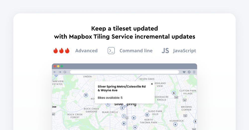
📊 Transform raw spatial data into map-ready vector tiles with Mapbox Tiling Service.
This tutorial shows you how to create a vector tileset using Mapbox Tiling Service (MTS) and keep it updated efficiently with incremental updates whenever your data changes.
This tutorial shows you how to create a vector tileset using Mapbox Tiling Service (MTS) and keep it updated efficiently with incremental updates whenever your data changes.
September 25, 2025 at 2:16 PM
📊 Transform raw spatial data into map-ready vector tiles with Mapbox Tiling Service.
This tutorial shows you how to create a vector tileset using Mapbox Tiling Service (MTS) and keep it updated efficiently with incremental updates whenever your data changes.
This tutorial shows you how to create a vector tileset using Mapbox Tiling Service (MTS) and keep it updated efficiently with incremental updates whenever your data changes.