


Lelan Statom
@lelanstatom.bsky.social
Senior Meteorologist; Co-Host, Talk of the Town-WTVF-NewsChannel 5 Network, Nashville, #NC5; Emmy Winner, 3x TN @AP Best WX, NWAS Broadcaster of the Year lelan.statom@newschannel5.com
We'll see lots of clouds today with some hits of sunshine, especially
for our southern counties. Highs will on reach the mid to low 60svfor many of our Kentucky counties while reaching the mid to low
70s for southern Middle TN.
for our southern counties. Highs will on reach the mid to low 60svfor many of our Kentucky counties while reaching the mid to low
70s for southern Middle TN.


November 19, 2025 at 12:30 PM
We'll see lots of clouds today with some hits of sunshine, especially
for our southern counties. Highs will on reach the mid to low 60svfor many of our Kentucky counties while reaching the mid to low
70s for southern Middle TN.
for our southern counties. Highs will on reach the mid to low 60svfor many of our Kentucky counties while reaching the mid to low
70s for southern Middle TN.

It'll be mild and breezy today with gusts from 20-30 mph. There's a chance for some showers today, but a lot of you won't see much during the day. By late day and early tonight, scattered showers and thunderstorms will develop, A few of those storms could be strong to severe. #NC5 #tnwx #kywx
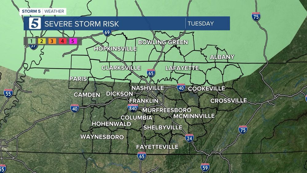

November 18, 2025 at 12:37 PM
Breaking: I-24 East near Harding Place
Metro Fire Dept. quickly extinguish the flames on a tractor trailer fire near Antioch......
More details on #NC5 This Morning... #5LiveTraffic
Metro Fire Dept. quickly extinguish the flames on a tractor trailer fire near Antioch......
More details on #NC5 This Morning... #5LiveTraffic


November 17, 2025 at 12:29 PM
Breaking: I-24 East near Harding Place
Metro Fire Dept. quickly extinguish the flames on a tractor trailer fire near Antioch......
More details on #NC5 This Morning... #5LiveTraffic
Metro Fire Dept. quickly extinguish the flames on a tractor trailer fire near Antioch......
More details on #NC5 This Morning... #5LiveTraffic
BREAKING: I-24 West is CLOSED near mile marker 11 in the Clarksville area. #Sky5 has spotted one car in the Red River and another car off to the side of the interstate.


November 13, 2025 at 12:42 PM
BREAKING: I-24 West is CLOSED near mile marker 11 in the Clarksville area. #Sky5 has spotted one car in the Red River and another car off to the side of the interstate.
Northern Lights in the Mid-South….
The 1st picture is from my iPhone. The 2nd pic is from our 5am producer in Gallatin, & the 3rd is from an #NC5 viewer in Westmoreland.
I only saw blackness with my naked eyes. I only saw color with my iPhone 14.
Send to my5@newschannel5.com
The 1st picture is from my iPhone. The 2nd pic is from our 5am producer in Gallatin, & the 3rd is from an #NC5 viewer in Westmoreland.
I only saw blackness with my naked eyes. I only saw color with my iPhone 14.
Send to my5@newschannel5.com


November 12, 2025 at 2:09 AM
Northern Lights in the Mid-South….
The 1st picture is from my iPhone. The 2nd pic is from our 5am producer in Gallatin, & the 3rd is from an #NC5 viewer in Westmoreland.
I only saw blackness with my naked eyes. I only saw color with my iPhone 14.
Send to my5@newschannel5.com
The 1st picture is from my iPhone. The 2nd pic is from our 5am producer in Gallatin, & the 3rd is from an #NC5 viewer in Westmoreland.
I only saw blackness with my naked eyes. I only saw color with my iPhone 14.
Send to my5@newschannel5.com
🫶🏿 We did it! Over $500,000 for our neighbors in need. Thank you to everyone who donated -- you directly helped so many families in our community.

November 12, 2025 at 12:57 AM
🫶🏿 We did it! Over $500,000 for our neighbors in need. Thank you to everyone who donated -- you directly helped so many families in our community.
To all who have served—we thank you for your service and dedication to our country!

November 11, 2025 at 8:32 PM
To all who have served—we thank you for your service and dedication to our country!
Love #NC5 Viewer Pictures...
Here's one of a Frost Flower This Morning by Jeff Humberson!
#NC5 #tnwx #frostflower
Here's one of a Frost Flower This Morning by Jeff Humberson!
#NC5 #tnwx #frostflower

November 11, 2025 at 5:34 PM
Love #NC5 Viewer Pictures...
Here's one of a Frost Flower This Morning by Jeff Humberson!
#NC5 #tnwx #frostflower
Here's one of a Frost Flower This Morning by Jeff Humberson!
#NC5 #tnwx #frostflower
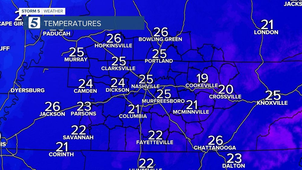
Cold start to Veterans Day!
Most of us have temps in the mid to low 20s. Later, highs will reach the upper 40s to low 50s. While that's better than Monday's high of 36°, it's still below the normal high of 63°. We see temps in the 70s this weekend.
#NC5 #tnwx #kywx #ArcticBlast
Most of us have temps in the mid to low 20s. Later, highs will reach the upper 40s to low 50s. While that's better than Monday's high of 36°, it's still below the normal high of 63°. We see temps in the 70s this weekend.
#NC5 #tnwx #kywx #ArcticBlast


November 11, 2025 at 12:43 PM
Cold start to Veterans Day!
Most of us have temps in the mid to low 20s. Later, highs will reach the upper 40s to low 50s. While that's better than Monday's high of 36°, it's still below the normal high of 63°. We see temps in the 70s this weekend.
#NC5 #tnwx #kywx #ArcticBlast
Most of us have temps in the mid to low 20s. Later, highs will reach the upper 40s to low 50s. While that's better than Monday's high of 36°, it's still below the normal high of 63°. We see temps in the 70s this weekend.
#NC5 #tnwx #kywx #ArcticBlast
From TN Emergency Management Agency
As the season's first cold weather arrives, make sure to access available resources, stay warm, bring pets inside and check on neighbors who may need help.
Please follow guidance from local officials for more information on resources available in your community.
As the season's first cold weather arrives, make sure to access available resources, stay warm, bring pets inside and check on neighbors who may need help.
Please follow guidance from local officials for more information on resources available in your community.

November 9, 2025 at 6:39 PM
From TN Emergency Management Agency
As the season's first cold weather arrives, make sure to access available resources, stay warm, bring pets inside and check on neighbors who may need help.
Please follow guidance from local officials for more information on resources available in your community.
As the season's first cold weather arrives, make sure to access available resources, stay warm, bring pets inside and check on neighbors who may need help.
Please follow guidance from local officials for more information on resources available in your community.

Part of the tornado watch has been canceled…

November 7, 2025 at 11:22 PM
Part of the tornado watch has been canceled…
“The Federal Aviation Administration (FAA) has issued a ground stop at Nashville International Airport® (BNA®) due to weather. Travelers should check their flight status with their airline. Safe travels!” #BNAFYI

November 7, 2025 at 10:48 PM
“The Federal Aviation Administration (FAA) has issued a ground stop at Nashville International Airport® (BNA®) due to weather. Travelers should check their flight status with their airline. Safe travels!” #BNAFYI

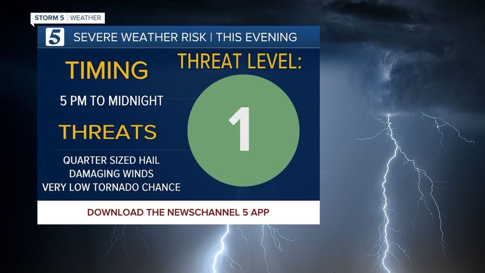
Stay Weather Aware from 2pm-10pm Today!
A cold front will move across the area later today with a line of showers and thunderstorms. A few of the storms along the line could be strong to severe.
#NC5 #tnwx #kywx #Storm5Alert
A cold front will move across the area later today with a line of showers and thunderstorms. A few of the storms along the line could be strong to severe.
#NC5 #tnwx #kywx #Storm5Alert


November 7, 2025 at 1:57 PM
Stay Weather Aware from 2pm-10pm Today!
A cold front will move across the area later today with a line of showers and thunderstorms. A few of the storms along the line could be strong to severe.
#NC5 #tnwx #kywx #Storm5Alert
A cold front will move across the area later today with a line of showers and thunderstorms. A few of the storms along the line could be strong to severe.
#NC5 #tnwx #kywx #Storm5Alert

THANK-YOU! Your support has been AMAZING!
We've teamed with Second Harvest Food Bank for a Hunger Can't Wait campaign to support our community members. You can help!
Swing by any Second Harvest location or Kroger store to donate items. Scan the QR code for a direct donation.
We've teamed with Second Harvest Food Bank for a Hunger Can't Wait campaign to support our community members. You can help!
Swing by any Second Harvest location or Kroger store to donate items. Scan the QR code for a direct donation.


October 30, 2025 at 6:07 PM
THANK-YOU! Your support has been AMAZING!
We've teamed with Second Harvest Food Bank for a Hunger Can't Wait campaign to support our community members. You can help!
Swing by any Second Harvest location or Kroger store to donate items. Scan the QR code for a direct donation.
We've teamed with Second Harvest Food Bank for a Hunger Can't Wait campaign to support our community members. You can help!
Swing by any Second Harvest location or Kroger store to donate items. Scan the QR code for a direct donation.
The showers will continue through the day. A rumble or two of thunder can't be ruled out, but this is a rain event.
As low pressures moves across the region, it'll keep our temperatures steady with daytime highs in the mid to low 50s. Winds will pick up to 10-15 mph with gusts to 25 mph.
As low pressures moves across the region, it'll keep our temperatures steady with daytime highs in the mid to low 50s. Winds will pick up to 10-15 mph with gusts to 25 mph.


October 29, 2025 at 2:49 PM
The showers will continue through the day. A rumble or two of thunder can't be ruled out, but this is a rain event.
As low pressures moves across the region, it'll keep our temperatures steady with daytime highs in the mid to low 50s. Winds will pick up to 10-15 mph with gusts to 25 mph.
As low pressures moves across the region, it'll keep our temperatures steady with daytime highs in the mid to low 50s. Winds will pick up to 10-15 mph with gusts to 25 mph.
It’s official! Vols Baseball Coach Tony Vitello is heading to the San Francisco Giants

October 22, 2025 at 6:47 PM
It’s official! Vols Baseball Coach Tony Vitello is heading to the San Francisco Giants


October 22, 2025 at 12:21 AM
Big Blue Weekend @NissanStadium
@Titans today, @TSU_Tigers Homecoming Saturday
Game time temp today: 61° vs 81° yesterday
Thanks @NissanUSA for the invitation for the #TSU game!
@Titans today, @TSU_Tigers Homecoming Saturday
Game time temp today: 61° vs 81° yesterday
Thanks @NissanUSA for the invitation for the #TSU game!


October 19, 2025 at 7:18 PM
Big Blue Weekend @NissanStadium
@Titans today, @TSU_Tigers Homecoming Saturday
Game time temp today: 61° vs 81° yesterday
Thanks @NissanUSA for the invitation for the #TSU game!
@Titans today, @TSU_Tigers Homecoming Saturday
Game time temp today: 61° vs 81° yesterday
Thanks @NissanUSA for the invitation for the #TSU game!


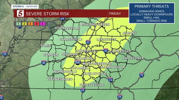
Strong to Severe Thunderstorms Possible Tonight!
Stay Weather Aware tonight into early Sunday morning. We have a Storm 5 Alert from 10pm-3am.
Today: Sunny Start with Record Warmth Possible. High: 88°, Current Record: 87°
Becoming Pt . Cloudy & Breezy
Stay Weather Aware tonight into early Sunday morning. We have a Storm 5 Alert from 10pm-3am.
Today: Sunny Start with Record Warmth Possible. High: 88°, Current Record: 87°
Becoming Pt . Cloudy & Breezy


October 18, 2025 at 2:24 PM
Strong to Severe Thunderstorms Possible Tonight!
Stay Weather Aware tonight into early Sunday morning. We have a Storm 5 Alert from 10pm-3am.
Today: Sunny Start with Record Warmth Possible. High: 88°, Current Record: 87°
Becoming Pt . Cloudy & Breezy
Stay Weather Aware tonight into early Sunday morning. We have a Storm 5 Alert from 10pm-3am.
Today: Sunny Start with Record Warmth Possible. High: 88°, Current Record: 87°
Becoming Pt . Cloudy & Breezy
Beautiful weather today! Chance for strong to severe thunderstorms Sat. afternoon/evening - We’ll continue to watch timing. We could see record warmth Sat with much cooler air Sun. Stay warm the #Storm5Weater team & @NC5 for the latest. #tnwx #kywx


October 16, 2025 at 2:25 PM
Beautiful weather today! Chance for strong to severe thunderstorms Sat. afternoon/evening - We’ll continue to watch timing. We could see record warmth Sat with much cooler air Sun. Stay warm the #Storm5Weater team & @NC5 for the latest. #tnwx #kywx