


Larry O'Neill
@larryoneill.bsky.social
I specialize in air-sea interactions, observations of weather, ocean, and climate, and science outreach and engagement. Associate Professor at Oregon State Univ. State Climatologist of Oregon. Director, Oregon Climate Service. @occri.bsky.social
The Emigrant Fire in the central Oregon Cascades has burned over 6000 acres at this point in an area that has received record or near-record low precipitation since April 1st this year (based on 45 years of data), as shown by nearby SNOTEL stations.

August 26, 2025 at 6:19 PM
The Emigrant Fire in the central Oregon Cascades has burned over 6000 acres at this point in an area that has received record or near-record low precipitation since April 1st this year (based on 45 years of data), as shown by nearby SNOTEL stations.
Well, here's a live look at the situation, the Emigrant Fire.

August 26, 2025 at 12:57 AM
Well, here's a live look at the situation, the Emigrant Fire.
The Emigrant Fire in the central Oregon Cascades is unfortunately growing rapidly and is now sprouting a broad pyrocumulus cloud, as seen from the Univ of Oregon Wildfire camera placed on Peak 2 of Willamette Pass ski resort.

August 26, 2025 at 12:47 AM
The Emigrant Fire in the central Oregon Cascades is unfortunately growing rapidly and is now sprouting a broad pyrocumulus cloud, as seen from the Univ of Oregon Wildfire camera placed on Peak 2 of Willamette Pass ski resort.
Yikes, I tried it with ChatGPT and got something different but similarly very wrong.

August 8, 2025 at 10:30 PM
Yikes, I tried it with ChatGPT and got something different but similarly very wrong.

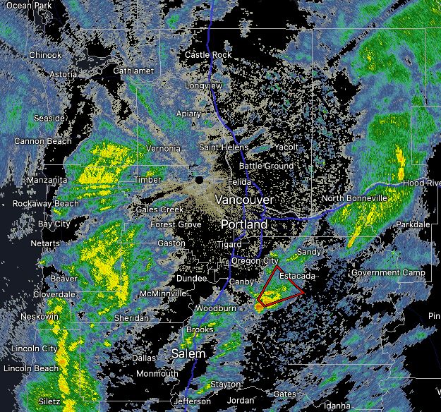
The forecast was for a slight chance of severe hail, not for a certainty. This is from the NWS Portland forecast discussion this morning. Again, the problem here is not understanding probabilistic forecasts.
March 27, 2025 at 5:02 AM
The forecast was for a slight chance of severe hail, not for a certainty. This is from the NWS Portland forecast discussion this morning. Again, the problem here is not understanding probabilistic forecasts.
I launched a sonde earlier today from Corvallis, Oregon just before noon. The sounding indicated pretty good CAPE and a lot of shear. But it also showed the strong low-level cap that ended up limiting the convective potential.

March 27, 2025 at 3:59 AM
I launched a sonde earlier today from Corvallis, Oregon just before noon. The sounding indicated pretty good CAPE and a lot of shear. But it also showed the strong low-level cap that ended up limiting the convective potential.
It is just by the Volcano Canyon in which the American River runs through! Also, the Mosquito Fire two years ago burned through the area. The Western States 100 Mile race also runs through Foresthill and Michigan Bluff just to the north of the canyon.

March 5, 2025 at 7:37 PM
It is just by the Volcano Canyon in which the American River runs through! Also, the Mosquito Fire two years ago burned through the area. The Western States 100 Mile race also runs through Foresthill and Michigan Bluff just to the north of the canyon.
Good news -- Larry the chicken at NWS Portland has not yet been relieved of their duties.

February 26, 2025 at 10:55 PM
Good news -- Larry the chicken at NWS Portland has not yet been relieved of their duties.
Now I'm going to raise you a tornado warning.
February 25, 2025 at 1:55 AM
Now I'm going to raise you a tornado warning.
I'll raise you this. Severe thunderstorm warnings in Oregon... in February!
February 25, 2025 at 12:42 AM
I'll raise you this. Severe thunderstorm warnings in Oregon... in February!
Here's a stuffed moose, for those that celebrate. We're in this together.

February 19, 2025 at 6:03 AM
Here's a stuffed moose, for those that celebrate. We're in this together.
The ECMWF ensemble plumes for Eugene are looking interesting for this weekend!

January 27, 2025 at 11:07 PM
The ECMWF ensemble plumes for Eugene are looking interesting for this weekend!
The Willamette Valley had a nice wave come through evident in the low stratus cloud field. It behaved a bit like a seiche would in a body of water, except in this case it acted on the cold air pooled into the valley! #orwx
December 4, 2024 at 9:56 PM
The Willamette Valley had a nice wave come through evident in the low stratus cloud field. It behaved a bit like a seiche would in a body of water, except in this case it acted on the cold air pooled into the valley! #orwx
Something else unusual about this PacNW storm that is emerging is the amount of lightning associated with it. This is not remotely typical of November weather in the Pacific Northwest.

November 20, 2024 at 5:19 AM
Something else unusual about this PacNW storm that is emerging is the amount of lightning associated with it. This is not remotely typical of November weather in the Pacific Northwest.
Some perspective on this PacNW storm. The analog is that of the Columbus Day storm of 1962. During that storm, the surface pressure reached an estimated 948mb, while today's storm reached 945mb. The impact difference: today's storm stalled 200 miles off the coast, while the 1962 storm breached it.

November 20, 2024 at 2:14 AM
Some perspective on this PacNW storm. The analog is that of the Columbus Day storm of 1962. During that storm, the surface pressure reached an estimated 948mb, while today's storm reached 945mb. The impact difference: today's storm stalled 200 miles off the coast, while the 1962 storm breached it.
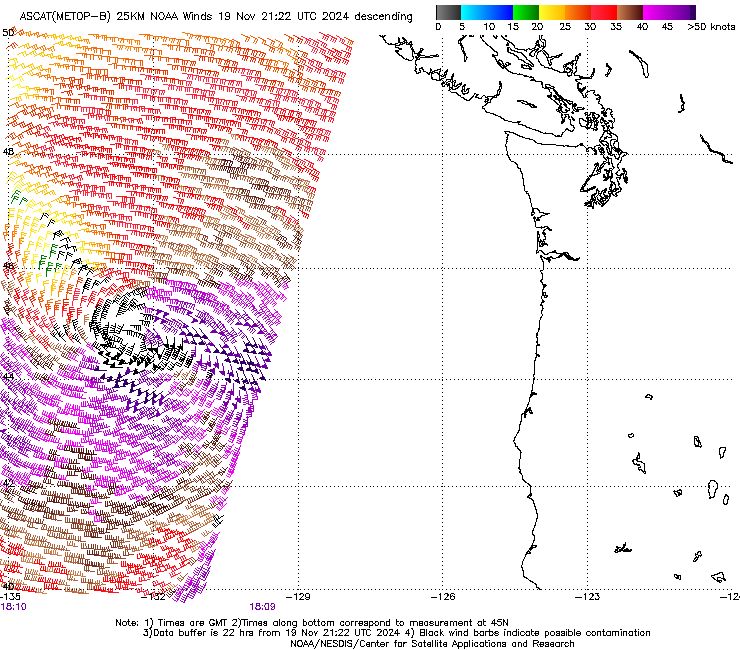
The analysis field looks pretty close to the satellite surface wind measurements!
November 19, 2024 at 9:45 PM
The analysis field looks pretty close to the satellite surface wind measurements!
For the PacNW, the latest satellite imagery is in on the cyclone from ASCAT-B, which measures surface wind speed and direction over the ocean. It indicates >60 knot sustained winds wrapping around the south and eastern part of the low, which is still well offshore. Forecast looks well on track.
November 19, 2024 at 9:43 PM
For the PacNW, the latest satellite imagery is in on the cyclone from ASCAT-B, which measures surface wind speed and direction over the ocean. It indicates >60 knot sustained winds wrapping around the south and eastern part of the low, which is still well offshore. Forecast looks well on track.
Satellite surface wind estimates from AMSR2 indicate 30 m/s (60 knot) sustained winds wrapping west and south of the low as of about 6am PST.

November 19, 2024 at 7:04 PM
Satellite surface wind estimates from AMSR2 indicate 30 m/s (60 knot) sustained winds wrapping west and south of the low as of about 6am PST.
Buoy 46005 is probably the closest to the bomb cyclone this morning and its surface pressure is dropping fast -- 1013mb to 978mb in about the last 24 hours. The main low is still about 100-200 miles south of this buoy, so the central pressure of the system is likely somewhat lower than this.


November 19, 2024 at 7:00 PM
Buoy 46005 is probably the closest to the bomb cyclone this morning and its surface pressure is dropping fast -- 1013mb to 978mb in about the last 24 hours. The main low is still about 100-200 miles south of this buoy, so the central pressure of the system is likely somewhat lower than this.
Current forecasts show rapid development of an extremely strong cyclone off the Pacific Northwest coast by late Tuesday afternoon. Its projected strength, as measured by sea level pressure, is <950mb, which could set records. Here are the record low pressures in this part of the world since 1979.

November 19, 2024 at 3:37 AM
Current forecasts show rapid development of an extremely strong cyclone off the Pacific Northwest coast by late Tuesday afternoon. Its projected strength, as measured by sea level pressure, is <950mb, which could set records. Here are the record low pressures in this part of the world since 1979.
The incipient low for the cyclone forecast to impact the Pacific NW tomorrow looked completely unremarkable late this morning (circled, left). In 36 hours, it is forecast to deepen from 1016mb to 947mb. It is a marvel of modern weather forecasting that these features can be skillfully forecast.


November 19, 2024 at 1:29 AM
The incipient low for the cyclone forecast to impact the Pacific NW tomorrow looked completely unremarkable late this morning (circled, left). In 36 hours, it is forecast to deepen from 1016mb to 947mb. It is a marvel of modern weather forecasting that these features can be skillfully forecast.
The low intensity forecast will be close to a record low in the ERA5 hourly going back to 1979.

November 19, 2024 at 12:37 AM
The low intensity forecast will be close to a record low in the ERA5 hourly going back to 1979.
Forecast confidence is increasing that an historically strong low pressure system will approach the Pacific Northwest Tuesday evening. One forecast has the low at about 950mb. If it occurs at that strength, it will be the strongest low in this area since at least 1979.


November 18, 2024 at 9:01 PM
Forecast confidence is increasing that an historically strong low pressure system will approach the Pacific Northwest Tuesday evening. One forecast has the low at about 950mb. If it occurs at that strength, it will be the strongest low in this area since at least 1979.
❄️ The mountain snowpack in Oregon is off to a great start so far. During the winter of 2017-2018, the Cascades got off to a similarly great start, but ended up being well below average. A great start to snow season does not guarantee it will end well! #orwx

November 18, 2024 at 7:03 PM
❄️ The mountain snowpack in Oregon is off to a great start so far. During the winter of 2017-2018, the Cascades got off to a similarly great start, but ended up being well below average. A great start to snow season does not guarantee it will end well! #orwx