


Kevin Myatt
@kevinmyattwx.bsky.social
Weather writer for Cardinal News, covering SW & S'side Virginia. Senior writer/editor for Virginia-Maryland College of Veterinary Medicine at Virginia Tech. Also on X (@kevinmyattwx) and Facebook (Kevin Myatt's Weather Wonders).
Roanoke avg high temps for 1st week of August have deep bookends as 74.6 in 2025 has beat out 76 from 1912, 1st year of data, for coolest on record. Avg temps figuring highs & lows slightly favor 1912, with 2025 2nd. Either way, historically cool start to Aug, slow warming ahead.

August 8, 2025 at 1:55 PM
Roanoke avg high temps for 1st week of August have deep bookends as 74.6 in 2025 has beat out 76 from 1912, 1st year of data, for coolest on record. Avg temps figuring highs & lows slightly favor 1912, with 2025 2nd. Either way, historically cool start to Aug, slow warming ahead.
Tropical Storm Chantal rain potential has ticked west on this Sunday. Some Southside Virginia areas may get band of 1-2 inches, locally more possible, with scattered showers/storms westward to near Blue Ridge. This starts return to stickier pattern with daily shower/storm chances in week ahead.

July 6, 2025 at 12:14 PM
Tropical Storm Chantal rain potential has ticked west on this Sunday. Some Southside Virginia areas may get band of 1-2 inches, locally more possible, with scattered showers/storms westward to near Blue Ridge. This starts return to stickier pattern with daily shower/storm chances in week ahead.
Tropical Storm Chantal expected to move NW into Carolinas on Sunday. Highly unlikely this storm will become a hurricane or move enough inland for significant rainfall in SW/S'side Virginia. Heat/humidity will edge upward next few days with chances of showers and storms slowly increasing.


July 5, 2025 at 1:47 PM
Tropical Storm Chantal expected to move NW into Carolinas on Sunday. Highly unlikely this storm will become a hurricane or move enough inland for significant rainfall in SW/S'side Virginia. Heat/humidity will edge upward next few days with chances of showers and storms slowly increasing.
Rough day of severe storms/tornadoes on this Friday to our west where Ohio/Miss rivers meet east into central Ky. For Va: (1) scattered storms/storm clusters during day that might be severe; (2) larger storm complex from west overnight, arriving well after peak heating but gusty winds possible.

May 16, 2025 at 12:03 PM
Rough day of severe storms/tornadoes on this Friday to our west where Ohio/Miss rivers meet east into central Ky. For Va: (1) scattered storms/storm clusters during day that might be severe; (2) larger storm complex from west overnight, arriving well after peak heating but gusty winds possible.
Flood watch (green) Mon-Tues follows beige stripe of moderate drought across Va. Preceding dryness reduces flood risk but still could be a bit too much runoff a little too fast for some. Widespread 1-3 inches, locally 4+, mostly light-moderate rain but heavier spurts in t-storms.


May 12, 2025 at 11:38 AM
Flood watch (green) Mon-Tues follows beige stripe of moderate drought across Va. Preceding dryness reduces flood risk but still could be a bit too much runoff a little too fast for some. Widespread 1-3 inches, locally 4+, mostly light-moderate rain but heavier spurts in t-storms.
Perhaps some helpful weekend rain with stalling upper-level low/slow-moving front to ease light-moderate drought in much of Va. Best chance Sat PM/early Sun AM so may be timed to spare at least part of weekend days from washout. Sporadic showers/storms possible anytime Fri-Mon.


May 2, 2025 at 1:16 PM
Perhaps some helpful weekend rain with stalling upper-level low/slow-moving front to ease light-moderate drought in much of Va. Best chance Sat PM/early Sun AM so may be timed to spare at least part of weekend days from washout. Sporadic showers/storms possible anytime Fri-Mon.
Some showers in western Virginia off and on through the week as fronts move in from west, stall, dawdle. But amounts in Virginia look relatively light as heavier rain/severe storms focus in central U.S. Neither a sunny week nor a still-needed soaking rain likely.

April 22, 2025 at 1:29 PM
Some showers in western Virginia off and on through the week as fronts move in from west, stall, dawdle. But amounts in Virginia look relatively light as heavier rain/severe storms focus in central U.S. Neither a sunny week nor a still-needed soaking rain likely.
Don't rule out a shower/storm especially N/W of Roanoke by Mon PM, with marginal to slight risk of a few severe storms with damaging wind and large hail. New front brings more windy cool weather Tues-Wed, possible frost/freeze Thurs AM. Warmer over Easter weekend into next week.

April 14, 2025 at 12:22 PM
Don't rule out a shower/storm especially N/W of Roanoke by Mon PM, with marginal to slight risk of a few severe storms with damaging wind and large hail. New front brings more windy cool weather Tues-Wed, possible frost/freeze Thurs AM. Warmer over Easter weekend into next week.
Spring blossoms and a tufted titmouse pecking on my window this chilly April Saturday morning along the Blue Ridge in southern Roanoke County, Virginia.

April 12, 2025 at 12:59 PM
Spring blossoms and a tufted titmouse pecking on my window this chilly April Saturday morning along the Blue Ridge in southern Roanoke County, Virginia.
Periods of rain on the way for Southwest/Southside Va with slow-moving low-pressure trough starting on this Thurs afternoon and continuing to early Saturday. Most rainfall amounts 1/2 to 1.25 inches, still needed with ongoing dryness. (Base map courtesy of Weather Prediction Center, NOAA)

April 10, 2025 at 12:08 PM
Periods of rain on the way for Southwest/Southside Va with slow-moving low-pressure trough starting on this Thurs afternoon and continuing to early Saturday. Most rainfall amounts 1/2 to 1.25 inches, still needed with ongoing dryness. (Base map courtesy of Weather Prediction Center, NOAA)
Protect tender plants from subfreezing temps across much of Virginia early Wednesday.

April 8, 2025 at 5:02 PM
Protect tender plants from subfreezing temps across much of Virginia early Wednesday.
Where I grew up in NE Arkansas in high risk of severe storms with likely long-track violent tornadoes. Hope it underperforms badly. 6+ inches of rain expected same area next 4 days. Wish we could spread 1-2 of that out here to Virginia where it's dry, but showers thru weekend look light.

April 2, 2025 at 1:17 PM
Where I grew up in NE Arkansas in high risk of severe storms with likely long-track violent tornadoes. Hope it underperforms badly. 6+ inches of rain expected same area next 4 days. Wish we could spread 1-2 of that out here to Virginia where it's dry, but showers thru weekend look light.
Familiar progression in Va with approaching front. Severe storms outbreak to west as showers increase here today/tonight. Storm risk picks up Mon, some possibly severe, especially east of the Blue Ridge. Rain amounts mostly short of needed soaking. Windy & cooler Mon PM-Tues.

March 30, 2025 at 1:10 PM
Familiar progression in Va with approaching front. Severe storms outbreak to west as showers increase here today/tonight. Storm risk picks up Mon, some possibly severe, especially east of the Blue Ridge. Rain amounts mostly short of needed soaking. Windy & cooler Mon PM-Tues.
Same song, umpteenth verse in this dry, windy March. Red flag warning for extreme fire danger has been issued along and east of the Blue Ridge, but fires can spread quickly anywhere in Virginia and nearby states on this Wednesday.

March 26, 2025 at 1:18 PM
Same song, umpteenth verse in this dry, windy March. Red flag warning for extreme fire danger has been issued along and east of the Blue Ridge, but fires can spread quickly anywhere in Virginia and nearby states on this Wednesday.
Familiar script for Virginia on Sunday. Likely high-end severe outbreak to our west on this Sat, then strong shear aloft but less instability in Va on Sun. Less severe risk than South/TN Valley but still significant, gusty winds, tornadoes possible, more so east of Blue Ridge.

March 15, 2025 at 2:37 PM
Familiar script for Virginia on Sunday. Likely high-end severe outbreak to our west on this Sat, then strong shear aloft but less instability in Va on Sun. Less severe risk than South/TN Valley but still significant, gusty winds, tornadoes possible, more so east of Blue Ridge.
Mammatus over Roanoke skyline and surrounding mountains as seen from Virginia Western Community College on this Wednesday morning Formed by cool air sinking. Indicative of considerable turbulence but also in this case that heavy rain/storms have moved on to east. Photo by my wife, Erica Myatt
.
.

March 5, 2025 at 4:09 PM
Mammatus over Roanoke skyline and surrounding mountains as seen from Virginia Western Community College on this Wednesday morning Formed by cool air sinking. Indicative of considerable turbulence but also in this case that heavy rain/storms have moved on to east. Photo by my wife, Erica Myatt
.
.
Bands of snow moving into western Va this AM. Expect briefly lowered visibility and quick accumulations of mostly 1 inch or less as these move through. These are a result of atmospheric lift aloft not strictly upslope surface flow so will likely move out past the mountains.
February 20, 2025 at 11:39 AM
Bands of snow moving into western Va this AM. Expect briefly lowered visibility and quick accumulations of mostly 1 inch or less as these move through. These are a result of atmospheric lift aloft not strictly upslope surface flow so will likely move out past the mountains.
Current NWS-Blacksburg forecast for snowfall on Wed in SW/S'side Va. Some significant variables linger that could pump up these amounts or dry them out yet a little more.

February 18, 2025 at 2:57 AM
Current NWS-Blacksburg forecast for snowfall on Wed in SW/S'side Va. Some significant variables linger that could pump up these amounts or dry them out yet a little more.
This morning's NWS-Blacksburg snow forecast map reflects guidance that is a bit colder and more stubborn for snow & later sleet to change to freezing rain especially along I-81 & U.S. 460 corridors and northward. Always tricky to call so don't get too locked into specific number.

February 11, 2025 at 1:27 PM
This morning's NWS-Blacksburg snow forecast map reflects guidance that is a bit colder and more stubborn for snow & later sleet to change to freezing rain especially along I-81 & U.S. 460 corridors and northward. Always tricky to call so don't get too locked into specific number.
Lovely sunrise to start an oddly mild February day for many across SW/S'side Va. After 60s on this Tues, cold-air wedge against mtns brings 30s & rain Wed, with patchy freezing rain possible N & W of Roanoke by Wed PM/Thurs AM. Mild again late week but next week is full of wintry intrigue.

February 4, 2025 at 4:08 PM
Lovely sunrise to start an oddly mild February day for many across SW/S'side Va. After 60s on this Tues, cold-air wedge against mtns brings 30s & rain Wed, with patchy freezing rain possible N & W of Roanoke by Wed PM/Thurs AM. Mild again late week but next week is full of wintry intrigue.
This will be beneficial to help quell the fire danger that produced a large fire in Wades Gap Road area of Franklin County and moisten dry soil. Perhaps a little too much too fast atop thick snowpack in eastern WVa mountains. Mild temps through at least first week of Feb.

January 30, 2025 at 3:00 PM
This will be beneficial to help quell the fire danger that produced a large fire in Wades Gap Road area of Franklin County and moisten dry soil. Perhaps a little too much too fast atop thick snowpack in eastern WVa mountains. Mild temps through at least first week of Feb.
Thaw is coming. Highs reach 50s in much of SW/S'side Va by Tues-Wed, maybe 60s for some, before late-week windy cold shot, then mild spell 1st week of Feb. Winter likely not done with us but unclear if that means occasional Arctic jabs or full-on relapse 2nd week of Feb & later.

January 25, 2025 at 11:54 PM
Thaw is coming. Highs reach 50s in much of SW/S'side Va by Tues-Wed, maybe 60s for some, before late-week windy cold shot, then mild spell 1st week of Feb. Winter likely not done with us but unclear if that means occasional Arctic jabs or full-on relapse 2nd week of Feb & later.
Map from NWS-Blacksburg gives a solid idea of snow expectations on Sunday. Dark blue has high chance of at least 1 inch, with some getting 2-3 inches. Medium shades of blue are near a coin-flip for 1 inch, with perhaps 2 in some spots. Light blue is less than 50% for 1 inch.

January 19, 2025 at 12:49 AM
Map from NWS-Blacksburg gives a solid idea of snow expectations on Sunday. Dark blue has high chance of at least 1 inch, with some getting 2-3 inches. Medium shades of blue are near a coin-flip for 1 inch, with perhaps 2 in some spots. Light blue is less than 50% for 1 inch.
I'm not sure when the last time Roanoke had a third of an inch of ice accretion, certainly hasn't happened in my two decades-plus following local weather. Temps in upper 20s might wiggle into lower 30s but probably don't rise above freezing with prior snowpack.
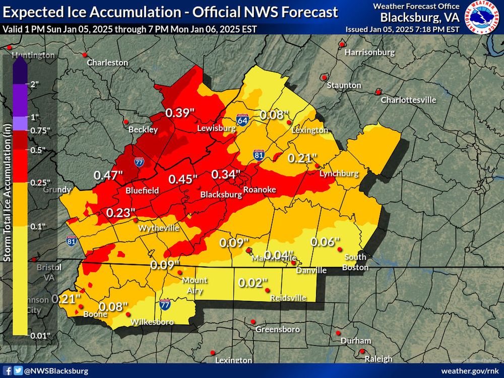
January 6, 2025 at 3:08 AM
I'm not sure when the last time Roanoke had a third of an inch of ice accretion, certainly hasn't happened in my two decades-plus following local weather. Temps in upper 20s might wiggle into lower 30s but probably don't rise above freezing with prior snowpack.
History made today when the National Weather Service office at Blacksburg issued its first snow squall warning, as band of snow quickly reduced visibility and covered some roadways.

January 3, 2025 at 10:11 PM
History made today when the National Weather Service office at Blacksburg issued its first snow squall warning, as band of snow quickly reduced visibility and covered some roadways.