


Kai Sonder
@kaisonder.bsky.social
Agricultural geographer, futurist, cyclist, zwifter, Member of Noodles, passionate coffee drinker
#30DayMapChallenge Day 10: Air
The obvious one is air quality, annual PM2.5 particles from Wei et al., 2023 in Nature Communications. Interesting to see natural and human hot spots.
The obvious one is air quality, annual PM2.5 particles from Wei et al., 2023 in Nature Communications. Interesting to see natural and human hot spots.

November 10, 2025 at 4:10 PM
#30DayMapChallenge Day 10: Air
The obvious one is air quality, annual PM2.5 particles from Wei et al., 2023 in Nature Communications. Interesting to see natural and human hot spots.
The obvious one is air quality, annual PM2.5 particles from Wei et al., 2023 in Nature Communications. Interesting to see natural and human hot spots.
#30DayMapChallenge Day 9 - Analog
Time to cheat as I don't draw well enough to do analog
National Institute of Statistics and Geography of Mexico (INEGI) topo map and 15 m elevation model off the place I work at @cimmyt.bsky.social
Time to cheat as I don't draw well enough to do analog
National Institute of Statistics and Geography of Mexico (INEGI) topo map and 15 m elevation model off the place I work at @cimmyt.bsky.social

November 10, 2025 at 2:22 AM
#30DayMapChallenge Day 9 - Analog
Time to cheat as I don't draw well enough to do analog
National Institute of Statistics and Geography of Mexico (INEGI) topo map and 15 m elevation model off the place I work at @cimmyt.bsky.social
Time to cheat as I don't draw well enough to do analog
National Institute of Statistics and Geography of Mexico (INEGI) topo map and 15 m elevation model off the place I work at @cimmyt.bsky.social
#30DayMapchallenge Day 8, Urban. Data from European Commission (JRC), Center for Integrated Earth System Information (CIESIN) and NASA - National Aeronautics and Space Administration, rendered with #aerialod
Urban areas in Mexico
Urban areas in Mexico

November 8, 2025 at 6:07 PM
#30DayMapchallenge Day 8, Urban. Data from European Commission (JRC), Center for Integrated Earth System Information (CIESIN) and NASA - National Aeronautics and Space Administration, rendered with #aerialod
Urban areas in Mexico
Urban areas in Mexico
#30DayMapChallenge Day 7 — Accessibility
Distance to different sized towns
Distance to different sized towns


November 7, 2025 at 4:15 PM
#30DayMapChallenge Day 7 — Accessibility
Distance to different sized towns
Distance to different sized towns
Day 6 of #30DayMapChallenge: Dimensions
Some countries pop up (USA, China, Brazil), some stay almost the same (Mexico, Turkey) some disappear (Australia UK). 2023 maize production as a cartogram. Thx to
@fao.org stat and Gastner et al. Proc Natl Acad Sci (2018) online tool.
Some countries pop up (USA, China, Brazil), some stay almost the same (Mexico, Turkey) some disappear (Australia UK). 2023 maize production as a cartogram. Thx to
@fao.org stat and Gastner et al. Proc Natl Acad Sci (2018) online tool.

November 6, 2025 at 10:17 PM
Day 6 of #30DayMapChallenge: Dimensions
Some countries pop up (USA, China, Brazil), some stay almost the same (Mexico, Turkey) some disappear (Australia UK). 2023 maize production as a cartogram. Thx to
@fao.org stat and Gastner et al. Proc Natl Acad Sci (2018) online tool.
Some countries pop up (USA, China, Brazil), some stay almost the same (Mexico, Turkey) some disappear (Australia UK). 2023 maize production as a cartogram. Thx to
@fao.org stat and Gastner et al. Proc Natl Acad Sci (2018) online tool.
#30DayMapChallenge – Day 5: Earth
Given the importance of these, global occurrence of rare earth elements according to U.S. Geological Survey (USGS) and the great hashtag#rayrender package in R.
Given the importance of these, global occurrence of rare earth elements according to U.S. Geological Survey (USGS) and the great hashtag#rayrender package in R.
November 5, 2025 at 2:55 PM
#30DayMapChallenge – Day 5: Earth
Given the importance of these, global occurrence of rare earth elements according to U.S. Geological Survey (USGS) and the great hashtag#rayrender package in R.
Given the importance of these, global occurrence of rare earth elements according to U.S. Geological Survey (USGS) and the great hashtag#rayrender package in R.
#30DayMapChallenge Day4: My Data/Our Data
Use of cost distance grids to review and plan for improved accessibility of farmers in Central Mexico to conservation agriculture machinery for climate change adaptation and more regenerative farming practices within @cimmyt.bsky.social MasAgro initiative.
Use of cost distance grids to review and plan for improved accessibility of farmers in Central Mexico to conservation agriculture machinery for climate change adaptation and more regenerative farming practices within @cimmyt.bsky.social MasAgro initiative.

November 4, 2025 at 3:19 PM
#30DayMapChallenge Day4: My Data/Our Data
Use of cost distance grids to review and plan for improved accessibility of farmers in Central Mexico to conservation agriculture machinery for climate change adaptation and more regenerative farming practices within @cimmyt.bsky.social MasAgro initiative.
Use of cost distance grids to review and plan for improved accessibility of farmers in Central Mexico to conservation agriculture machinery for climate change adaptation and more regenerative farming practices within @cimmyt.bsky.social MasAgro initiative.
#30DayMapChallenge Day 3 - Polygons
While Mexico is still recovering from several years of drought, here is how 2024 looked like.
Great drought data from @conagua_mx and inspiration from ESRI's @John_M_Nelson
While Mexico is still recovering from several years of drought, here is how 2024 looked like.
Great drought data from @conagua_mx and inspiration from ESRI's @John_M_Nelson
November 3, 2025 at 2:55 PM
#30DayMapChallenge Day 3 - Polygons
While Mexico is still recovering from several years of drought, here is how 2024 looked like.
Great drought data from @conagua_mx and inspiration from ESRI's @John_M_Nelson
While Mexico is still recovering from several years of drought, here is how 2024 looked like.
Great drought data from @conagua_mx and inspiration from ESRI's @John_M_Nelson

November 2, 2025 at 3:47 PM
#30DayMapChallenge
Day 1: Points
Volcanoes in abundance
Data ESRI and Global Volcanism Program, Pacific Data Hub
Day 1: Points
Volcanoes in abundance
Data ESRI and Global Volcanism Program, Pacific Data Hub

November 1, 2025 at 5:28 PM
#30DayMapChallenge
Day 1: Points
Volcanoes in abundance
Data ESRI and Global Volcanism Program, Pacific Data Hub
Day 1: Points
Volcanoes in abundance
Data ESRI and Global Volcanism Program, Pacific Data Hub
Every year @cimmyt.bsky.social wheat breeders send out the new nurseries with high yield potential and resistance to biotic and abiotic stresses for testing to many collaborators in the world both in the public and private sector.
Rendered in R with #rayrender by @tylermw.com .
Rendered in R with #rayrender by @tylermw.com .
May 11, 2025 at 3:45 PM
Every year @cimmyt.bsky.social wheat breeders send out the new nurseries with high yield potential and resistance to biotic and abiotic stresses for testing to many collaborators in the world both in the public and private sector.
Rendered in R with #rayrender by @tylermw.com .
Rendered in R with #rayrender by @tylermw.com .

March 21, 2025 at 11:00 PM
Integrated approaches to maximizing #maize resistance to fall armyworm
#CIMMYT #USDA
www.cabidigitallibrary.org/doi/10.1079/...
#CIMMYT #USDA
www.cabidigitallibrary.org/doi/10.1079/...

March 6, 2025 at 4:26 PM
Integrated approaches to maximizing #maize resistance to fall armyworm
#CIMMYT #USDA
www.cabidigitallibrary.org/doi/10.1079/...
#CIMMYT #USDA
www.cabidigitallibrary.org/doi/10.1079/...
Want a side of CO₂ with that? Better food labels help us choose more climate-friendly foods
Carbon footprint of what you eat
theconversation.com/want-a-side-...
Carbon footprint of what you eat
theconversation.com/want-a-side-...

February 27, 2025 at 2:41 PM
Want a side of CO₂ with that? Better food labels help us choose more climate-friendly foods
Carbon footprint of what you eat
theconversation.com/want-a-side-...
Carbon footprint of what you eat
theconversation.com/want-a-side-...
Mapped: How extreme weather is destroying crops around the world
lnkd.in/eR_cfand
lnkd.in/eR_cfand
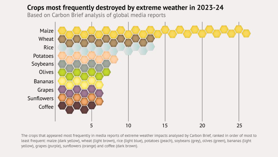
February 16, 2025 at 4:38 PM
Mapped: How extreme weather is destroying crops around the world
lnkd.in/eR_cfand
lnkd.in/eR_cfand
Data-driven strategies to improve nitrogen use efficiency of rice farming in South Asia
How to reduce emissions while staying productive through use of modern technolgies
@cimmyt @IRRI @cgiar.org
www.nature.com/articles/s41...
How to reduce emissions while staying productive through use of modern technolgies
@cimmyt @IRRI @cgiar.org
www.nature.com/articles/s41...

February 13, 2025 at 2:11 PM
Data-driven strategies to improve nitrogen use efficiency of rice farming in South Asia
How to reduce emissions while staying productive through use of modern technolgies
@cimmyt @IRRI @cgiar.org
www.nature.com/articles/s41...
How to reduce emissions while staying productive through use of modern technolgies
@cimmyt @IRRI @cgiar.org
www.nature.com/articles/s41...
Adoption of improved crop varieties limited biodiversity losses, terrestrial carbon emissions, and cropland expansion in the tropics
The value of the #cgiar breeding programs beyond higher yields
www.pnas.org/doi/10.1073/...
The value of the #cgiar breeding programs beyond higher yields
www.pnas.org/doi/10.1073/...

February 5, 2025 at 8:23 PM
Adoption of improved crop varieties limited biodiversity losses, terrestrial carbon emissions, and cropland expansion in the tropics
The value of the #cgiar breeding programs beyond higher yields
www.pnas.org/doi/10.1073/...
The value of the #cgiar breeding programs beyond higher yields
www.pnas.org/doi/10.1073/...
Why biodiversity matters in agriculture and food systems
www.science.org/doi/full/10....
Image Jonas frei
www.science.org/doi/full/10....
Image Jonas frei

December 28, 2024 at 5:15 PM
Why biodiversity matters in agriculture and food systems
www.science.org/doi/full/10....
Image Jonas frei
www.science.org/doi/full/10....
Image Jonas frei

#30DayMapChallenge, Day 30, The Final Map.
The Final map takes me to the beginning.
The place I was born at: Hospital Amazonico in Yarina-Cocha, Peru from Sentinel 2 as Normalized Difference Water Index (NDWI) image. Copernicus Browser and Overture
The Final map takes me to the beginning.
The place I was born at: Hospital Amazonico in Yarina-Cocha, Peru from Sentinel 2 as Normalized Difference Water Index (NDWI) image. Copernicus Browser and Overture

November 30, 2024 at 5:53 PM
#30DayMapChallenge, Day 30, The Final Map.
The Final map takes me to the beginning.
The place I was born at: Hospital Amazonico in Yarina-Cocha, Peru from Sentinel 2 as Normalized Difference Water Index (NDWI) image. Copernicus Browser and Overture
The Final map takes me to the beginning.
The place I was born at: Hospital Amazonico in Yarina-Cocha, Peru from Sentinel 2 as Normalized Difference Water Index (NDWI) image. Copernicus Browser and Overture
#30DayMapChallenge Day 29 Data: Overture
Pity there are no building heights for the town of Campeche but at least easy access to this huge data set in Qgis thx to @gishub.org www.youtube.com/watch?v=6lfV...
Pity there are no building heights for the town of Campeche but at least easy access to this huge data set in Qgis thx to @gishub.org www.youtube.com/watch?v=6lfV...

November 29, 2024 at 2:23 PM
#30DayMapChallenge Day 29 Data: Overture
Pity there are no building heights for the town of Campeche but at least easy access to this huge data set in Qgis thx to @gishub.org www.youtube.com/watch?v=6lfV...
Pity there are no building heights for the town of Campeche but at least easy access to this huge data set in Qgis thx to @gishub.org www.youtube.com/watch?v=6lfV...
#30DayMapChallenge - Day 28: The Blue Planet
GEBCO data and aerialod at it's best
GEBCO data and aerialod at it's best

November 28, 2024 at 3:44 PM
#30DayMapChallenge - Day 28: The Blue Planet
GEBCO data and aerialod at it's best
GEBCO data and aerialod at it's best
#30DayMapChallenge - Day 28: The Blue Planet

November 28, 2024 at 2:24 PM
#30DayMapChallenge - Day 28: The Blue Planet
#30DayMapChallenge · Day 27 · Micromapping
As I just found out we can do 3D mapping stuff without having to buy an expensive phone with LIDAR I decided to try the app Luma. Impressive yet need to practice a bit more with making the video for the data.
As I just found out we can do 3D mapping stuff without having to buy an expensive phone with LIDAR I decided to try the app Luma. Impressive yet need to practice a bit more with making the video for the data.
November 27, 2024 at 2:17 PM
#30DayMapChallenge · Day 27 · Micromapping
As I just found out we can do 3D mapping stuff without having to buy an expensive phone with LIDAR I decided to try the app Luma. Impressive yet need to practice a bit more with making the video for the data.
As I just found out we can do 3D mapping stuff without having to buy an expensive phone with LIDAR I decided to try the app Luma. Impressive yet need to practice a bit more with making the video for the data.
#30DayMapChallenge · Day 25 · Heat
Crop residue burning in Guanajuato state, Mexico.
Time to switch to conservation agriculture systems for climate smarter agriculture, carbon sequestration and less emissions
Was supposed to be a gif animation but X didn't like the format.
Crop residue burning in Guanajuato state, Mexico.
Time to switch to conservation agriculture systems for climate smarter agriculture, carbon sequestration and less emissions
Was supposed to be a gif animation but X didn't like the format.

November 26, 2024 at 4:43 PM
#30DayMapChallenge · Day 25 · Heat
Crop residue burning in Guanajuato state, Mexico.
Time to switch to conservation agriculture systems for climate smarter agriculture, carbon sequestration and less emissions
Was supposed to be a gif animation but X didn't like the format.
Crop residue burning in Guanajuato state, Mexico.
Time to switch to conservation agriculture systems for climate smarter agriculture, carbon sequestration and less emissions
Was supposed to be a gif animation but X didn't like the format.