


Julie Elliott
@julieelliott.bsky.social
Research Faculty at Michigan State University. Geodesy, Tectonics, and Glaciers. All opinions my own.
Cool study that uses acoustic signals recorded at seismic sensors to identify aircraft type flying overhead (different aircraft have different frequency signatures). Alaska provides a lot of aircraft variety to evaluate. ⚒️🧪🚁
pubs.geoscienceworld.org/ssa/tsr/arti...
pubs.geoscienceworld.org/ssa/tsr/arti...

November 20, 2025 at 5:58 PM
Cool study that uses acoustic signals recorded at seismic sensors to identify aircraft type flying overhead (different aircraft have different frequency signatures). Alaska provides a lot of aircraft variety to evaluate. ⚒️🧪🚁
pubs.geoscienceworld.org/ssa/tsr/arti...
pubs.geoscienceworld.org/ssa/tsr/arti...
#30DayMapChallenge Day 4: My Data
Hardware stores I have visited/spent too much money in while doing fieldwork in southern and interior Alaska. Maybe one day I'll make it through a trip without needing to stop at a hardware store (but probably not).
Hardware stores I have visited/spent too much money in while doing fieldwork in southern and interior Alaska. Maybe one day I'll make it through a trip without needing to stop at a hardware store (but probably not).

November 5, 2025 at 5:00 AM
#30DayMapChallenge Day 4: My Data
Hardware stores I have visited/spent too much money in while doing fieldwork in southern and interior Alaska. Maybe one day I'll make it through a trip without needing to stop at a hardware store (but probably not).
Hardware stores I have visited/spent too much money in while doing fieldwork in southern and interior Alaska. Maybe one day I'll make it through a trip without needing to stop at a hardware store (but probably not).
#30DayMapChallenge Day 2: Lines
Think your commute is rough? Here are migration paths of Arctic terns that breed in Alaska. Each color represents the round trip track for an individual tagged bird. Migration data source in comment. Map made with the Generic Mapping Tools (GMT).
Think your commute is rough? Here are migration paths of Arctic terns that breed in Alaska. Each color represents the round trip track for an individual tagged bird. Migration data source in comment. Map made with the Generic Mapping Tools (GMT).

November 2, 2025 at 9:16 PM
#30DayMapChallenge Day 2: Lines
Think your commute is rough? Here are migration paths of Arctic terns that breed in Alaska. Each color represents the round trip track for an individual tagged bird. Migration data source in comment. Map made with the Generic Mapping Tools (GMT).
Think your commute is rough? Here are migration paths of Arctic terns that breed in Alaska. Each color represents the round trip track for an individual tagged bird. Migration data source in comment. Map made with the Generic Mapping Tools (GMT).
Today is International GNSS Day. October 23 was chosen because 10.23 MHz is the foundational frequency for GPS. The world has become dependent on GNSS, but there are threats to service continuity. It is good to take a day to appreciate the value of GNSS. #geodesy www.ion.org/news/interna...

October 24, 2025 at 1:46 AM
Today is International GNSS Day. October 23 was chosen because 10.23 MHz is the foundational frequency for GPS. The world has become dependent on GNSS, but there are threats to service continuity. It is good to take a day to appreciate the value of GNSS. #geodesy www.ion.org/news/interna...
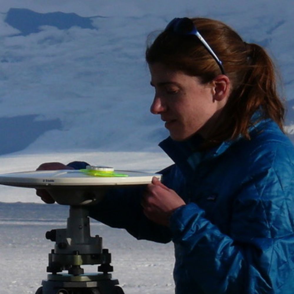
For #FieldworkFriday, some of the benchmarks I've surveyed over the past few weeks. Some are more challenging to use than others, but they're all interesting. #geodesy ⚒️🧪


October 4, 2025 at 12:29 AM
For #FieldworkFriday, some of the benchmarks I've surveyed over the past few weeks. Some are more challenging to use than others, but they're all interesting. #geodesy ⚒️🧪
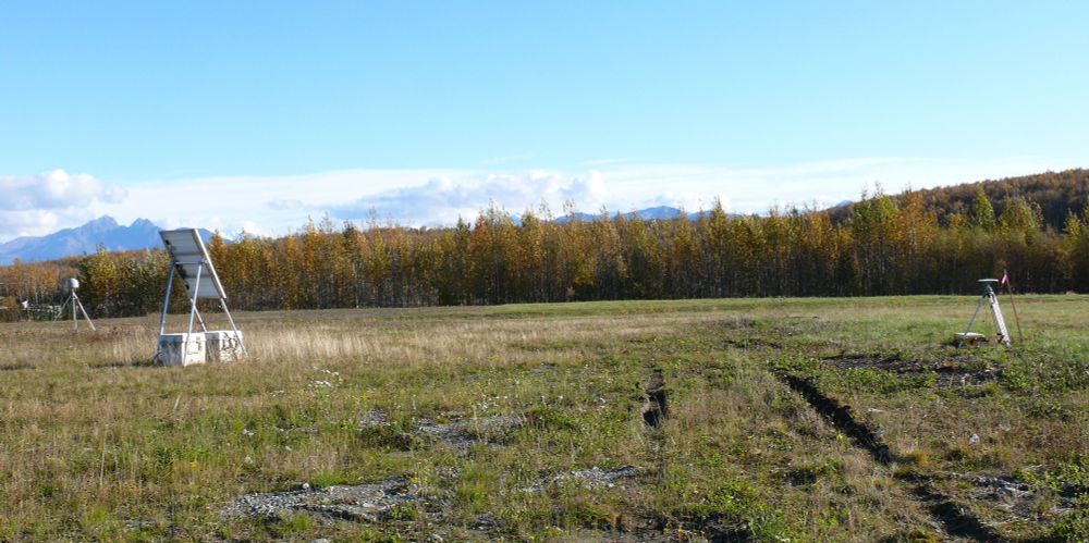
A campaign GNSS site in Willow, Alaska, set up to tie previous time series with the new EarthScope/NOTA continuous GNSS site nearby (the old NOTA site got whacked by a snow plow). The white crags in the center background are Mt. Foraker (left), Mt. Hunter (middle right), and Denali (far right). ⚒️🧪

October 2, 2025 at 2:31 AM
A campaign GNSS site in Willow, Alaska, set up to tie previous time series with the new EarthScope/NOTA continuous GNSS site nearby (the old NOTA site got whacked by a snow plow). The white crags in the center background are Mt. Foraker (left), Mt. Hunter (middle right), and Denali (far right). ⚒️🧪
Engaged in a bit of gardening this morning. In related news, I'm pretty sure I know why data from this GNSS site has been showing high levels of noise. Also, I hate cottonwood, alder, and their ilk. ⚒️🧪


October 1, 2025 at 9:55 PM
Engaged in a bit of gardening this morning. In related news, I'm pretty sure I know why data from this GNSS site has been showing high levels of noise. Also, I hate cottonwood, alder, and their ilk. ⚒️🧪
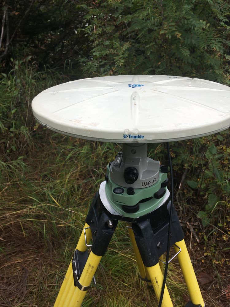
It might seem odd to set up a campaign GNSS site next to a continuous GNSS station, but running both at the same time allows the continuous time series to be tied to the longer campaign times series. Long time series rule! ⚒️🧪
October 1, 2025 at 3:17 PM
It might seem odd to set up a campaign GNSS site next to a continuous GNSS station, but running both at the same time allows the continuous time series to be tied to the longer campaign times series. Long time series rule! ⚒️🧪
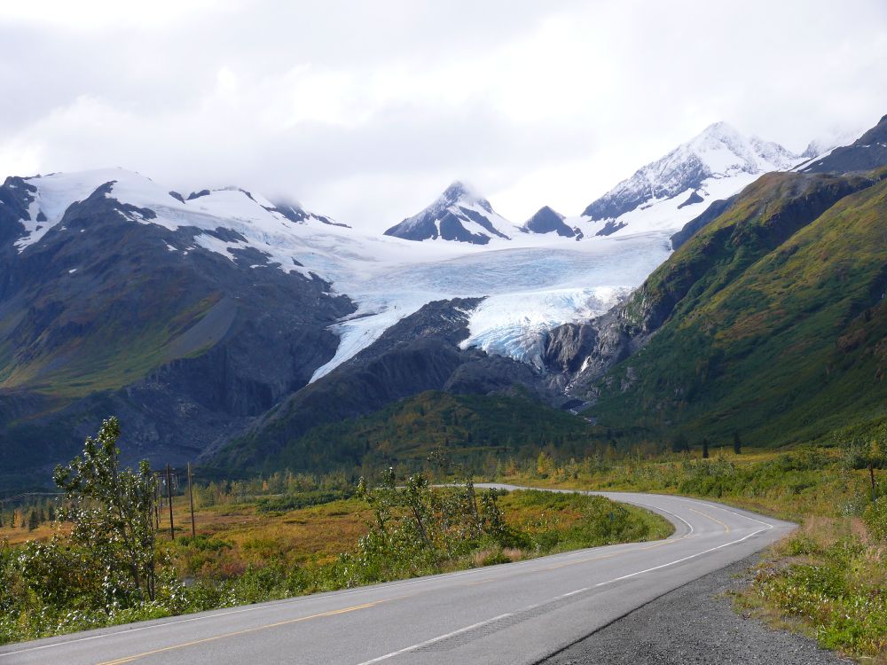
Some last photos from a GNSS field campaign done a couple of weeks ago before I head up to Alaska again for one more survey before snow sets in. There is bedrock under the benchmark - it was a very good moss season this summer. This site is near Thompson Pass in the Chugach. #FieldworkFriday 🧪⚒️


September 26, 2025 at 9:22 AM
Some last photos from a GNSS field campaign done a couple of weeks ago before I head up to Alaska again for one more survey before snow sets in. There is bedrock under the benchmark - it was a very good moss season this summer. This site is near Thompson Pass in the Chugach. #FieldworkFriday 🧪⚒️
A permanent/continuously operating GNSS site in the Wrangells with fresh batteries and solar panels operating at full capacity (had to do some pruning). Hopefully it is now ready to collect data without interruption over the winter. ⚒️🧪

September 18, 2025 at 4:04 PM
A permanent/continuously operating GNSS site in the Wrangells with fresh batteries and solar panels operating at full capacity (had to do some pruning). Hopefully it is now ready to collect data without interruption over the winter. ⚒️🧪
Harbor seal doing its thing in Valdez Harbor.

September 17, 2025 at 3:50 PM
Harbor seal doing its thing in Valdez Harbor.
A campaign GNSS site above an increasingly colorful Copper River Valley. The mountain at the center of the photo is Mount Blackburn, an eroded shield volcano and the tallest peak in the Wrangells. 20 years of surveying this benchmark and I've never seen Blackburn from here before. Gorgeous day. ⚒️🧪🌋


September 17, 2025 at 2:55 AM
A campaign GNSS site above an increasingly colorful Copper River Valley. The mountain at the center of the photo is Mount Blackburn, an eroded shield volcano and the tallest peak in the Wrangells. 20 years of surveying this benchmark and I've never seen Blackburn from here before. Gorgeous day. ⚒️🧪🌋
A tribute to the toughness and longevity of Trimble Zephyr Geodetic GPS/GNSS antennas: 18 years after the goat incident mentioned below, I just used the same antenna to set up a campaign survey site in another part of Alaska. Still tracks satellites just fine! #geodesy ⚒️🧪
September 15, 2025 at 10:46 PM
A tribute to the toughness and longevity of Trimble Zephyr Geodetic GPS/GNSS antennas: 18 years after the goat incident mentioned below, I just used the same antenna to set up a campaign survey site in another part of Alaska. Still tracks satellites just fine! #geodesy ⚒️🧪
A green comma butterfly taking a break on an interpretive sign along the Edgerton Highway between Kenny Lake and Chitina. Commas hibernate and overwinter in Alaska, making them tougher than many people.

September 15, 2025 at 6:31 PM
A green comma butterfly taking a break on an interpretive sign along the Edgerton Highway between Kenny Lake and Chitina. Commas hibernate and overwinter in Alaska, making them tougher than many people.
The Copper River (open the picture to see the full panorama) from the Edgerton Highway between Kenny Lake and Chitina.

September 15, 2025 at 3:42 PM
The Copper River (open the picture to see the full panorama) from the Edgerton Highway between Kenny Lake and Chitina.
A large mural showing penguins commuting at the Silver Spring Metro station. The world needs more murals like this.


August 27, 2025 at 12:43 AM
A large mural showing penguins commuting at the Silver Spring Metro station. The world needs more murals like this.
3-component ground motion visualization of the Kamchatka earthquake from EarthScope. Look at those seismic waves go through! ⚒️🧪
ds.iris.edu/spud/gmv/233...
ds.iris.edu/spud/gmv/233...
July 30, 2025 at 1:45 PM
3-component ground motion visualization of the Kamchatka earthquake from EarthScope. Look at those seismic waves go through! ⚒️🧪
ds.iris.edu/spud/gmv/233...
ds.iris.edu/spud/gmv/233...
Map showing today's earthquake (now 8.8), the earthquakes of July 20, and historic M7.5+ events along the subduction zone offshore Kamchatka. ⚒️

July 30, 2025 at 1:59 AM
Map showing today's earthquake (now 8.8), the earthquakes of July 20, and historic M7.5+ events along the subduction zone offshore Kamchatka. ⚒️
Happy 4th anniversary to the M8.2 Chignik earthquake, the largest (so far?) event in a complex earthquake sequence along the Alaska Peninsula segment of the Alaska subduction zone that keeps on giving more. The most recent event was an oblique strike-slip event in the upper plate on July 16. ⚒️

July 29, 2025 at 7:22 PM
Happy 4th anniversary to the M8.2 Chignik earthquake, the largest (so far?) event in a complex earthquake sequence along the Alaska Peninsula segment of the Alaska subduction zone that keeps on giving more. The most recent event was an oblique strike-slip event in the upper plate on July 16. ⚒️
The MSU undergraduate geodesy interns presented their projects at a symposium on campus yesterday. They've accomplished a great deal in the past seven weeks and they all did an excellent job talking about geodesy and their research. I'm looking forward to seeing what they do in the future! ⚒️🧪


July 24, 2025 at 6:06 PM
The MSU undergraduate geodesy interns presented their projects at a symposium on campus yesterday. They've accomplished a great deal in the past seven weeks and they all did an excellent job talking about geodesy and their research. I'm looking forward to seeing what they do in the future! ⚒️🧪
Updated with aftershocks (blue dots). The aftershocks (~50 so far) are concentrated in a band between Wednesday's M7.3 event and the 2020 M7.6 Sand Point earthquake. Details on sources in the alt text. ⚒️

July 18, 2025 at 7:36 PM
Updated with aftershocks (blue dots). The aftershocks (~50 so far) are concentrated in a band between Wednesday's M7.3 event and the 2020 M7.6 Sand Point earthquake. Details on sources in the alt text. ⚒️
Quick map of M7.3 earthquake offshore the Alaska Peninsula. Today's earthquake (green) has a very similar focal mechanism to the M7.8 2020 Sand Point event, which was dominantly strike-slip but caused a tsunami. Based on depths of mainshock and early aftershocks, could be an upper plate event. ⚒️

July 16, 2025 at 9:56 PM
Quick map of M7.3 earthquake offshore the Alaska Peninsula. Today's earthquake (green) has a very similar focal mechanism to the M7.8 2020 Sand Point event, which was dominantly strike-slip but caused a tsunami. Based on depths of mainshock and early aftershocks, could be an upper plate event. ⚒️
For #WorldOrcaDay, here are some video clips of an orca family I encountered while doing campaign GPS measurements via boat around Prince William Sound, Alaska in 2009. The calf got brave and did a little spy hop to check us out more closely. Maybe it wanted to learn geodesy?
July 14, 2025 at 9:34 PM
For #WorldOrcaDay, here are some video clips of an orca family I encountered while doing campaign GPS measurements via boat around Prince William Sound, Alaska in 2009. The calf got brave and did a little spy hop to check us out more closely. Maybe it wanted to learn geodesy?
Obviously, black oystercatchers are the superior oystercatchers. They hang out in fjords near the end of glaciers and pose in extremely photogenic ways.

July 12, 2025 at 1:51 PM
Obviously, black oystercatchers are the superior oystercatchers. They hang out in fjords near the end of glaciers and pose in extremely photogenic ways.
Earth Science solicited opportunities are very sparse this year. ⚒️

July 10, 2025 at 3:49 PM
Earth Science solicited opportunities are very sparse this year. ⚒️