


Jacopo Riboldi
@jriboldi.bsky.social
Lecturer in Atmospheric Dynamics at ETH Zurich 🇮🇹🇨🇭
Tackling climate research problems from a weather-centered perspective 🌦🌀🌡
Tackling climate research problems from a weather-centered perspective 🌦🌀🌡
Interestingly yes, it seems. This is an excerpt from the conclusions (in Spanish, but I think the first sentence is still understandable).

June 23, 2025 at 8:23 PM
Interestingly yes, it seems. This is an excerpt from the conclusions (in Spanish, but I think the first sentence is still understandable).
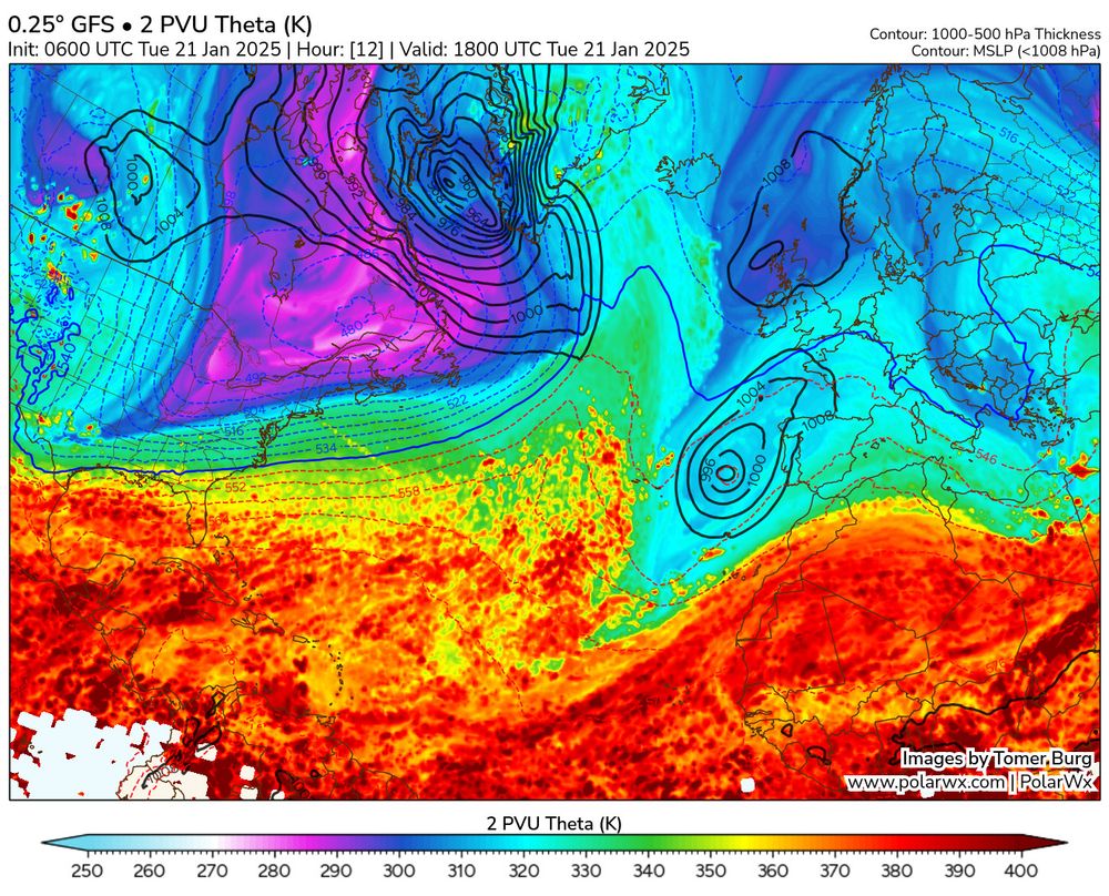
As noticed by @simonleewx.com, this event is a nice example of the "pathway" connecting central North America cold spells to windstorms over the British Isles just a few days later -see figure below, taken from doi.org/10.1029/2022...
(Anomalous 2m T in blue; magenta: jet stream; orange: sfc wind)
(Anomalous 2m T in blue; magenta: jet stream; orange: sfc wind)

January 21, 2025 at 4:02 PM
As noticed by @simonleewx.com, this event is a nice example of the "pathway" connecting central North America cold spells to windstorms over the British Isles just a few days later -see figure below, taken from doi.org/10.1029/2022...
(Anomalous 2m T in blue; magenta: jet stream; orange: sfc wind)
(Anomalous 2m T in blue; magenta: jet stream; orange: sfc wind)
It is high time to meditate on the effect that North American conditions can have on Europe (and not only from a meteorological viewpoint!)
In the current event, I like how it is the same trough now above the southern US that moves over the Atlantic to support the strong Atlantic cyclogenesis 🌀
In the current event, I like how it is the same trough now above the southern US that moves over the Atlantic to support the strong Atlantic cyclogenesis 🌀


January 21, 2025 at 3:54 PM
It is high time to meditate on the effect that North American conditions can have on Europe (and not only from a meteorological viewpoint!)
In the current event, I like how it is the same trough now above the southern US that moves over the Atlantic to support the strong Atlantic cyclogenesis 🌀
In the current event, I like how it is the same trough now above the southern US that moves over the Atlantic to support the strong Atlantic cyclogenesis 🌀
Winds will gradually weaken during Thursday as the cyclone slowly moves eastward.
Another impression of the importance of Rossby wave breaking events for different types of impactful extremes!
Another impression of the importance of Rossby wave breaking events for different types of impactful extremes!


January 8, 2025 at 6:01 PM
Winds will gradually weaken during Thursday as the cyclone slowly moves eastward.
Another impression of the importance of Rossby wave breaking events for different types of impactful extremes!
Another impression of the importance of Rossby wave breaking events for different types of impactful extremes!
They are driven by a deep, isolated upper-level cyclone over S California, that resulted from a spectacular anticyclonic Rossby wave breaking event over the west coast.
Notice the <-3σ anomalies (thanks @aliciambentley.bsky.social for the maps).
Notice the <-3σ anomalies (thanks @aliciambentley.bsky.social for the maps).


January 8, 2025 at 6:01 PM
They are driven by a deep, isolated upper-level cyclone over S California, that resulted from a spectacular anticyclonic Rossby wave breaking event over the west coast.
Notice the <-3σ anomalies (thanks @aliciambentley.bsky.social for the maps).
Notice the <-3σ anomalies (thanks @aliciambentley.bsky.social for the maps).
The fires ravaging the outskirts of Los Angeles are driven by anomalously strong easterly winds, locally known as 'Santa Ana winds".
Low-level winds speeds over the area exceed 5 standard deviations in anomaly (though wind speed is not gaussian, but ok).
But why are they so strong?
Low-level winds speeds over the area exceed 5 standard deviations in anomaly (though wind speed is not gaussian, but ok).
But why are they so strong?

January 8, 2025 at 6:01 PM
The fires ravaging the outskirts of Los Angeles are driven by anomalously strong easterly winds, locally known as 'Santa Ana winds".
Low-level winds speeds over the area exceed 5 standard deviations in anomaly (though wind speed is not gaussian, but ok).
But why are they so strong?
Low-level winds speeds over the area exceed 5 standard deviations in anomaly (though wind speed is not gaussian, but ok).
But why are they so strong?
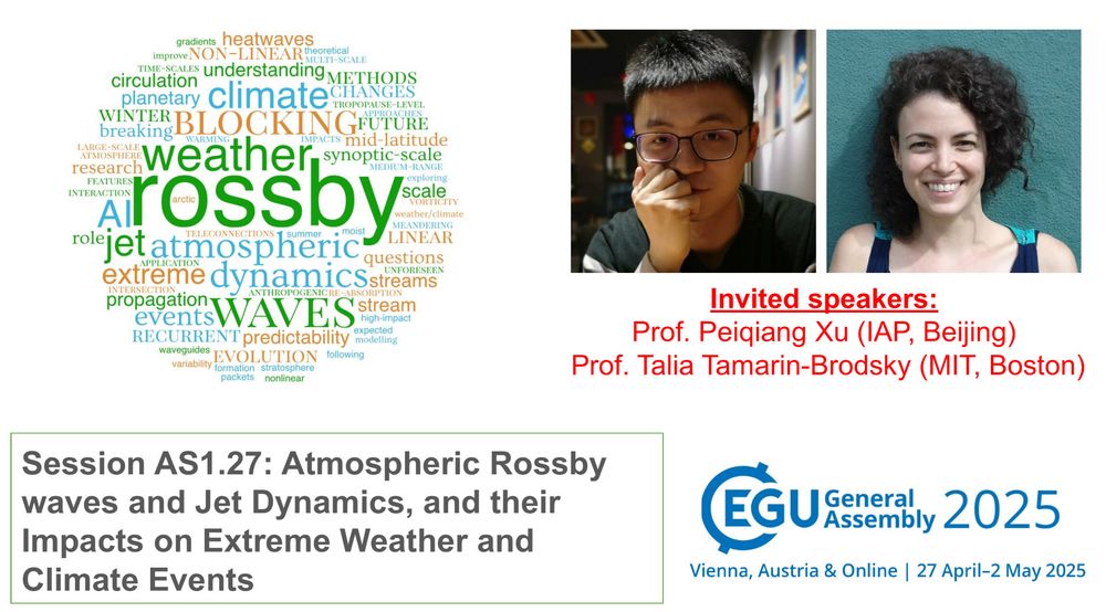
In 10 days, it is EGU25 submission deadline! 🚨
If your work involves large-scale dynamics and extreme weather/climate events, then consider submitting your abstract to the "Atmospheric Rossby Waves and Jet Dynamics" session! 🌬️〰️🌀
Invited speakers: Peiqiang Xu (IAP) and Talia Tamarin-Brodsky (MIT)!
If your work involves large-scale dynamics and extreme weather/climate events, then consider submitting your abstract to the "Atmospheric Rossby Waves and Jet Dynamics" session! 🌬️〰️🌀
Invited speakers: Peiqiang Xu (IAP) and Talia Tamarin-Brodsky (MIT)!
January 6, 2025 at 3:54 PM
In 10 days, it is EGU25 submission deadline! 🚨
If your work involves large-scale dynamics and extreme weather/climate events, then consider submitting your abstract to the "Atmospheric Rossby Waves and Jet Dynamics" session! 🌬️〰️🌀
Invited speakers: Peiqiang Xu (IAP) and Talia Tamarin-Brodsky (MIT)!
If your work involves large-scale dynamics and extreme weather/climate events, then consider submitting your abstract to the "Atmospheric Rossby Waves and Jet Dynamics" session! 🌬️〰️🌀
Invited speakers: Peiqiang Xu (IAP) and Talia Tamarin-Brodsky (MIT)!
I close this thread again with the warm core, showing the cyclone phase space plots by Robert Hart (data from ECMWF; moe.met.fsu.edu/cyclonephase...).
The cyclone is rapidly developing a deep, symmetric warm core as a result of the warm seclusion process (and maybe of some latent heat release?).
The cyclone is rapidly developing a deep, symmetric warm core as a result of the warm seclusion process (and maybe of some latent heat release?).


November 19, 2024 at 10:44 PM
I close this thread again with the warm core, showing the cyclone phase space plots by Robert Hart (data from ECMWF; moe.met.fsu.edu/cyclonephase...).
The cyclone is rapidly developing a deep, symmetric warm core as a result of the warm seclusion process (and maybe of some latent heat release?).
The cyclone is rapidly developing a deep, symmetric warm core as a result of the warm seclusion process (and maybe of some latent heat release?).
The storm propagated eastward along the baroclinic zone, always featuring heavy precipitation (and latent heat release) at its center.
Was it maybe a diabatic Rossby wave? One would need to check, but the likely presence of upper-level forcing for ascent would exclude it. (5/7)
Was it maybe a diabatic Rossby wave? One would need to check, but the likely presence of upper-level forcing for ascent would exclude it. (5/7)

November 19, 2024 at 10:44 PM
The storm propagated eastward along the baroclinic zone, always featuring heavy precipitation (and latent heat release) at its center.
Was it maybe a diabatic Rossby wave? One would need to check, but the likely presence of upper-level forcing for ascent would exclude it. (5/7)
Was it maybe a diabatic Rossby wave? One would need to check, but the likely presence of upper-level forcing for ascent would exclude it. (5/7)
It is interesting that on Monday the storm was barely existing: its precursor was a moist low-level vortex, located at the warm front of a cyclone centered around the date line.
This heavy precipitation area was likely tied to the right entrance of a short jet streak over the east Pacific. (4/7)
This heavy precipitation area was likely tied to the right entrance of a short jet streak over the east Pacific. (4/7)


November 19, 2024 at 10:44 PM
It is interesting that on Monday the storm was barely existing: its precursor was a moist low-level vortex, located at the warm front of a cyclone centered around the date line.
This heavy precipitation area was likely tied to the right entrance of a short jet streak over the east Pacific. (4/7)
This heavy precipitation area was likely tied to the right entrance of a short jet streak over the east Pacific. (4/7)
Even though this is NOT a tropical cyclone, the storm even features a "eye" with some relatively drier air at the center, surrounded by a moist "eyewall" (ok, maybe I am stretching a bit too much here). (3/7)

November 19, 2024 at 10:44 PM
Even though this is NOT a tropical cyclone, the storm even features a "eye" with some relatively drier air at the center, surrounded by a moist "eyewall" (ok, maybe I am stretching a bit too much here). (3/7)
The cyclone also boasts a vertically aligned PV tower, a typical feature of intense cyclones: low-level potential vorticity generation is usually tied to large latent heat release in clouds close to the cyclone center, corresponding to heavy precipitation. (2/7)


November 19, 2024 at 10:44 PM
The cyclone also boasts a vertically aligned PV tower, a typical feature of intense cyclones: low-level potential vorticity generation is usually tied to large latent heat release in clouds close to the cyclone center, corresponding to heavy precipitation. (2/7)
The 942hPa "bomb" cyclone roaring tonight off the west coast of N. America features a clear warm seclusion, making it a "warm-core" storm of non-tropical nature.
Downward-bending isentropes mark the warm core at the center. Winds around it decrease with height, following the thermal wind law (1/7)
Downward-bending isentropes mark the warm core at the center. Winds around it decrease with height, following the thermal wind law (1/7)


November 19, 2024 at 10:44 PM
The 942hPa "bomb" cyclone roaring tonight off the west coast of N. America features a clear warm seclusion, making it a "warm-core" storm of non-tropical nature.
Downward-bending isentropes mark the warm core at the center. Winds around it decrease with height, following the thermal wind law (1/7)
Downward-bending isentropes mark the warm core at the center. Winds around it decrease with height, following the thermal wind law (1/7)
Bluesky now has over 10 million users, and I was #2.247.128!
🦋🦋🦋🦋🦋
🦋🦋🦋🦋🦋

September 20, 2024 at 9:28 PM
Bluesky now has over 10 million users, and I was #2.247.128!
🦋🦋🦋🦋🦋
🦋🦋🦋🦋🦋
2c. The feature I probably like the most are the across-front wind changes in the cross section.
Left: northerly wind (coming out of the page) close to the surface in the cold air
Right: easterly wind (right-to-left, along cross-sect.) at the warm side.
The frontal boundary is visible in wind, too!
Left: northerly wind (coming out of the page) close to the surface in the cold air
Right: easterly wind (right-to-left, along cross-sect.) at the warm side.
The frontal boundary is visible in wind, too!


September 14, 2024 at 7:23 AM
2c. The feature I probably like the most are the across-front wind changes in the cross section.
Left: northerly wind (coming out of the page) close to the surface in the cold air
Right: easterly wind (right-to-left, along cross-sect.) at the warm side.
The frontal boundary is visible in wind, too!
Left: northerly wind (coming out of the page) close to the surface in the cold air
Right: easterly wind (right-to-left, along cross-sect.) at the warm side.
The frontal boundary is visible in wind, too!
2b. Drawing a cross section, we see the warm front proceeding from east to west, associated with ascent and precipitation. Without knowing, it would look like a cold front!
Model sounding indicate saturated conditions, anticyclonic veering with height ↘️⬇️↙️⬅️↖️ and a low-level jet.
Model sounding indicate saturated conditions, anticyclonic veering with height ↘️⬇️↙️⬅️↖️ and a low-level jet.


September 14, 2024 at 7:21 AM
2b. Drawing a cross section, we see the warm front proceeding from east to west, associated with ascent and precipitation. Without knowing, it would look like a cold front!
Model sounding indicate saturated conditions, anticyclonic veering with height ↘️⬇️↙️⬅️↖️ and a low-level jet.
Model sounding indicate saturated conditions, anticyclonic veering with height ↘️⬇️↙️⬅️↖️ and a low-level jet.
2a. The consequence of this complex flow pattern is impressive warm frontogenesis, here at 700hPa.
Here (thanks @TropicalTidbits) we see the warm temperature advection in warm colors over Poland/Czechia, and the strong temperature gradient in purple. Look at the wind change across the front!
Here (thanks @TropicalTidbits) we see the warm temperature advection in warm colors over Poland/Czechia, and the strong temperature gradient in purple. Look at the wind change across the front!

September 14, 2024 at 7:20 AM
2a. The consequence of this complex flow pattern is impressive warm frontogenesis, here at 700hPa.
Here (thanks @TropicalTidbits) we see the warm temperature advection in warm colors over Poland/Czechia, and the strong temperature gradient in purple. Look at the wind change across the front!
Here (thanks @TropicalTidbits) we see the warm temperature advection in warm colors over Poland/Czechia, and the strong temperature gradient in purple. Look at the wind change across the front!
1c. At the jet level, the easterlies over the heavy precipitation region are due to the cyclonic breaking of the trough.
Boris is supported by the the jet streak over Italy/Balkans: as the cut-off won't move much in the next few days, Boris will keep affecting the same regions.
Boris is supported by the the jet streak over Italy/Balkans: as the cut-off won't move much in the next few days, Boris will keep affecting the same regions.


September 14, 2024 at 7:19 AM
1c. At the jet level, the easterlies over the heavy precipitation region are due to the cyclonic breaking of the trough.
Boris is supported by the the jet streak over Italy/Balkans: as the cut-off won't move much in the next few days, Boris will keep affecting the same regions.
Boris is supported by the the jet streak over Italy/Balkans: as the cut-off won't move much in the next few days, Boris will keep affecting the same regions.
1b. The northerly wind is related to the strong pressure gradient between the anticyclone over France ("pushed" over Europe by the cyclone S of Iceland) and storm Boris.
It continues since Tuesday and is the responsible of the chilly weather we had during the week over western Europe ❄️
It continues since Tuesday and is the responsible of the chilly weather we had during the week over western Europe ❄️


September 14, 2024 at 7:17 AM
1b. The northerly wind is related to the strong pressure gradient between the anticyclone over France ("pushed" over Europe by the cyclone S of Iceland) and storm Boris.
It continues since Tuesday and is the responsible of the chilly weather we had during the week over western Europe ❄️
It continues since Tuesday and is the responsible of the chilly weather we had during the week over western Europe ❄️
1a. I find fascinating the complex structure of the flow in which the cyclone is embedded.
For example, focus on the cloudy area over CZ, where it is raining a lot. At the surface, strong northerly flow⬇️; at 300hPa, south-easterlies↖️ almost orthogonal to the isobars.
For example, focus on the cloudy area over CZ, where it is raining a lot. At the surface, strong northerly flow⬇️; at 300hPa, south-easterlies↖️ almost orthogonal to the isobars.

September 14, 2024 at 7:16 AM
1a. I find fascinating the complex structure of the flow in which the cyclone is embedded.
For example, focus on the cloudy area over CZ, where it is raining a lot. At the surface, strong northerly flow⬇️; at 300hPa, south-easterlies↖️ almost orthogonal to the isobars.
For example, focus on the cloudy area over CZ, where it is raining a lot. At the surface, strong northerly flow⬇️; at 300hPa, south-easterlies↖️ almost orthogonal to the isobars.
Cyclone Boris is affecting the weather of Eastern Europe for the next few days, bringing exceptional rainfall to Austria, Czech Republic and the neighboring countries. 🌧☔️🌫❄️
A thread with some meteorological aspects of this storm I found fascinating:
A thread with some meteorological aspects of this storm I found fascinating:


September 14, 2024 at 7:13 AM
Cyclone Boris is affecting the weather of Eastern Europe for the next few days, bringing exceptional rainfall to Austria, Czech Republic and the neighboring countries. 🌧☔️🌫❄️
A thread with some meteorological aspects of this storm I found fascinating:
A thread with some meteorological aspects of this storm I found fascinating:


Each of these 1⃣2⃣3⃣ took its own time to be reviewed, but we learnt so much during the process!
Next steps: extending the eigenvalue solution to non-zonally symmetric jets, trying to approach real-world flows.
Thanks to the lead author, A. Segalini, and to V. Wirth and G. Messori for this journey!
Next steps: extending the eigenvalue solution to non-zonally symmetric jets, trying to approach real-world flows.
Thanks to the lead author, A. Segalini, and to V. Wirth and G. Messori for this journey!

August 8, 2024 at 11:02 AM
Each of these 1⃣2⃣3⃣ took its own time to be reviewed, but we learnt so much during the process!
Next steps: extending the eigenvalue solution to non-zonally symmetric jets, trying to approach real-world flows.
Thanks to the lead author, A. Segalini, and to V. Wirth and G. Messori for this journey!
Next steps: extending the eigenvalue solution to non-zonally symmetric jets, trying to approach real-world flows.
Thanks to the lead author, A. Segalini, and to V. Wirth and G. Messori for this journey!
Why caring about jet latitude, though?
Because double jet configurations, that have been linked to Rossby waveguides, amplified Rossby waves and extreme events, feature jets at different latitudes!
We tried to assess waveguidability in double jet configurations and... (10/12)
Because double jet configurations, that have been linked to Rossby waveguides, amplified Rossby waves and extreme events, feature jets at different latitudes!
We tried to assess waveguidability in double jet configurations and... (10/12)

August 8, 2024 at 10:56 AM
Why caring about jet latitude, though?
Because double jet configurations, that have been linked to Rossby waveguides, amplified Rossby waves and extreme events, feature jets at different latitudes!
We tried to assess waveguidability in double jet configurations and... (10/12)
Because double jet configurations, that have been linked to Rossby waveguides, amplified Rossby waves and extreme events, feature jets at different latitudes!
We tried to assess waveguidability in double jet configurations and... (10/12)