


John Morales
@johnmoralestv.bsky.social
ClimaData® Certified Broadcast and Consulting Meteorologist
Hurricane Specialist for NBC Miami & Noticias SIN (DR)
Climate Change Columnist for Bulletin of the Atomic Scientists
BSc & Member of the Board of Trustees at Cornell | MSc at Johns Hopkins
Hurricane Specialist for NBC Miami & Noticias SIN (DR)
Climate Change Columnist for Bulletin of the Atomic Scientists
BSc & Member of the Board of Trustees at Cornell | MSc at Johns Hopkins
This week's full moon, known as the Beaver Moon, will be a #supermoon. It will reach full phase a few hours before perigee (its closest approach to Earth). As the closest super moon of 2025 it will be the brightest as well. (via @rtphokie.bsky.social)

November 4, 2025 at 3:21 PM
This week's full moon, known as the Beaver Moon, will be a #supermoon. It will reach full phase a few hours before perigee (its closest approach to Earth). As the closest super moon of 2025 it will be the brightest as well. (via @rtphokie.bsky.social)
The first earlier standard time #sunrise over Biscayne Bay was nice. (end of #daylightsavingtime)

November 2, 2025 at 3:16 PM
The first earlier standard time #sunrise over Biscayne Bay was nice. (end of #daylightsavingtime)
Thank you @cleoinstitute.bsky.social for the Circle of Change Award: “At a time when climate coverage faces unprecedented political pressure and censorship, John and the…team of @nbcmiami.com & Telemundo 51 continue to lead with science-driven facts and courage.” www.nbcmiami.com/news/local/j...

October 31, 2025 at 11:26 PM
Thank you @cleoinstitute.bsky.social for the Circle of Change Award: “At a time when climate coverage faces unprecedented political pressure and censorship, John and the…team of @nbcmiami.com & Telemundo 51 continue to lead with science-driven facts and courage.” www.nbcmiami.com/news/local/j...
"I feel compelled to make people realize that this is not going away, that this is going to continue to happen over and over again, and that we need to harden ourselves in every possible way and adapt to these increasing disasters." —part of yesterday's #Melissa coverage on @nbcmiami.com
October 29, 2025 at 1:25 PM
"I feel compelled to make people realize that this is not going away, that this is going to continue to happen over and over again, and that we need to harden ourselves in every possible way and adapt to these increasing disasters." —part of yesterday's #Melissa coverage on @nbcmiami.com
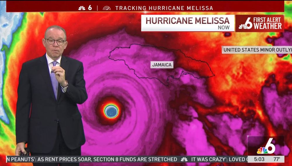
At NBC 6 since 4 am and until Melissa’s landfall this morning. Impacts in Jamaica are increasing as their strongest hurricane on record approaches. Winds 175 mph (280 km/hr) with gust factor of 1.5x➕ speeded up by hills & mountains. 13 ft (4 m) storm surge. 30-40 inches (1000 mm) storm total precip
October 28, 2025 at 11:43 AM
At NBC 6 since 4 am and until Melissa’s landfall this morning. Impacts in Jamaica are increasing as their strongest hurricane on record approaches. Winds 175 mph (280 km/hr) with gust factor of 1.5x➕ speeded up by hills & mountains. 13 ft (4 m) storm surge. 30-40 inches (1000 mm) storm total precip
At 901 millibars minimum central barometric pressure, #Melissa is the strongest hurricane ever recorded so late in a season in the Atlantic. It is also the 8th strongest Atlantic #hurricane during any part of the season. It is now sadly moving north-northeast towards #Jamaica.

October 28, 2025 at 7:17 AM
At 901 millibars minimum central barometric pressure, #Melissa is the strongest hurricane ever recorded so late in a season in the Atlantic. It is also the 8th strongest Atlantic #hurricane during any part of the season. It is now sadly moving north-northeast towards #Jamaica.
These unusually warm ocean temperatures, combined with overall tropical climate warming, are projected to have strengthened Melissa’s top wind speed by about 10 mph, and increased #Melissa potential damages by up to 50%. 2/2 fin

October 28, 2025 at 12:58 AM
These unusually warm ocean temperatures, combined with overall tropical climate warming, are projected to have strengthened Melissa’s top wind speed by about 10 mph, and increased #Melissa potential damages by up to 50%. 2/2 fin
During Melissa’s rapid intensification the storm drifted slowly over exceptionally warm ocean waters that were 1.4°C (2.5°F) warmer than average — these conditions were made up to 700 times more likely because of human-caused climate change. (via @climatecentral.org) 1/2

October 28, 2025 at 12:58 AM
During Melissa’s rapid intensification the storm drifted slowly over exceptionally warm ocean waters that were 1.4°C (2.5°F) warmer than average — these conditions were made up to 700 times more likely because of human-caused climate change. (via @climatecentral.org) 1/2
Melissa, now with sustained winds of 175 mph (280 km/hr) and capable of gusts to 260+ mph (425+ km/hr) on windward hilltops, 40" (1000 mm) of rain, and a 13 ft (4 m) storm surge, has started the feared turn to the northwest. First NW then north is the forecast. #Jamaica #HurricaneAlert
October 27, 2025 at 7:54 PM
Melissa, now with sustained winds of 175 mph (280 km/hr) and capable of gusts to 260+ mph (425+ km/hr) on windward hilltops, 40" (1000 mm) of rain, and a 13 ft (4 m) storm surge, has started the feared turn to the northwest. First NW then north is the forecast. #Jamaica #HurricaneAlert
My thesis at @jhuartssciences.bsky.social
hypothesized that bird takes during southward migration in busier hurricane seasons could mean fewer returning neotropical migrants in the spring. I feel for these little guys. See the remarks section of the ~1 pm Vortex Data Message in Melissa.
hypothesized that bird takes during southward migration in busier hurricane seasons could mean fewer returning neotropical migrants in the spring. I feel for these little guys. See the remarks section of the ~1 pm Vortex Data Message in Melissa.

October 27, 2025 at 7:54 PM
My thesis at @jhuartssciences.bsky.social
hypothesized that bird takes during southward migration in busier hurricane seasons could mean fewer returning neotropical migrants in the spring. I feel for these little guys. See the remarks section of the ~1 pm Vortex Data Message in Melissa.
hypothesized that bird takes during southward migration in busier hurricane seasons could mean fewer returning neotropical migrants in the spring. I feel for these little guys. See the remarks section of the ~1 pm Vortex Data Message in Melissa.
If you doubt the magnitude of gusts over mountainous islands, just ask Hurricane Marylin (1995) survivors in St. Thomas USVI. Storm total precipitation could reach 40 inches (1000 mm). And the coastal storm surge as high as 13 feet (4 m). The worst storm in #Jamaica history. 2/2 fin

October 27, 2025 at 3:50 PM
If you doubt the magnitude of gusts over mountainous islands, just ask Hurricane Marylin (1995) survivors in St. Thomas USVI. Storm total precipitation could reach 40 inches (1000 mm). And the coastal storm surge as high as 13 feet (4 m). The worst storm in #Jamaica history. 2/2 fin
Pressure down to 908 millibars, making #Melissa already the 11th strongest #hurricane on record in the Atlantic. It is still strengthening. Next on the list are Mitch (1998) and Dean (2007) at 905 mb. Sustained winds are up to 165 mph (270 km/hr). Topography can accelerate 1.5x✚

October 27, 2025 at 3:50 PM
Pressure down to 908 millibars, making #Melissa already the 11th strongest #hurricane on record in the Atlantic. It is still strengthening. Next on the list are Mitch (1998) and Dean (2007) at 905 mb. Sustained winds are up to 165 mph (270 km/hr). Topography can accelerate 1.5x✚


Doing this on a moonless night can't be fun. Pressure dropping precipitously, which will lead to continued strengthening. #Melissa is shooting for Category 5 intensity—third in Atlantic this year! It's likely to reach it. All signs point to a landfall in #Jamaica very early Tuesday. #HurricaneAlert


October 26, 2025 at 11:46 PM
Doing this on a moonless night can't be fun. Pressure dropping precipitously, which will lead to continued strengthening. #Melissa is shooting for Category 5 intensity—third in Atlantic this year! It's likely to reach it. All signs point to a landfall in #Jamaica very early Tuesday. #HurricaneAlert
"Extensive infrastructural damage, long-duration power and communication outages, and isolation of communities are expected." — expected impacts from #Melissa in #Jamaica according to NHC, which adds, "Seek shelter now." At 5pm Sunday, the #hurricane is Cat 4, winds 145 mph.
October 26, 2025 at 9:32 PM
"Extensive infrastructural damage, long-duration power and communication outages, and isolation of communities are expected." — expected impacts from #Melissa in #Jamaica according to NHC, which adds, "Seek shelter now." At 5pm Sunday, the #hurricane is Cat 4, winds 145 mph.
Category 4 🚨
Major Hurricane Melissa
5:00 AM EDT Sun Oct 26
Location: 16.3°N 76.3°W
Moving: W at 5 mph
Min pressure: 944 mb
Max sustained: 140 mph
(image via @tropicaltidbits.bsky.social)
Major Hurricane Melissa
5:00 AM EDT Sun Oct 26
Location: 16.3°N 76.3°W
Moving: W at 5 mph
Min pressure: 944 mb
Max sustained: 140 mph
(image via @tropicaltidbits.bsky.social)
October 26, 2025 at 9:02 AM
Category 4 🚨
Major Hurricane Melissa
5:00 AM EDT Sun Oct 26
Location: 16.3°N 76.3°W
Moving: W at 5 mph
Min pressure: 944 mb
Max sustained: 140 mph
(image via @tropicaltidbits.bsky.social)
Major Hurricane Melissa
5:00 AM EDT Sun Oct 26
Location: 16.3°N 76.3°W
Moving: W at 5 mph
Min pressure: 944 mb
Max sustained: 140 mph
(image via @tropicaltidbits.bsky.social)
Over the past 21 hours Hurricane #Melissa has undergone rapid intensification (RI). Nearly 80% of major hurricanes go through RI cycles to attain their devastating intensities. In the case of this cyclone, I believe we'll see Extreme RI with a gain of 58 mph or more in 24 hours. #Jamaica
October 26, 2025 at 1:22 AM
"Needless to say there is a very serious situation in terms of catastrophic rainfall wind and storm surge hazards for Jamaica and preparations should be rushed to completion in the area"
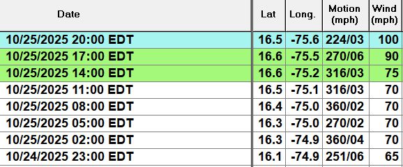
NHC explicitly calling for #Melissa to be a Cat 5 #hurricane on approach to #Jamaica (img @bmcnoldy.bsky.social)
NHC explicitly calling for #Melissa to be a Cat 5 #hurricane on approach to #Jamaica (img @bmcnoldy.bsky.social)
October 25, 2025 at 9:20 PM
"Needless to say there is a very serious situation in terms of catastrophic rainfall wind and storm surge hazards for Jamaica and preparations should be rushed to completion in the area"
NHC explicitly calling for #Melissa to be a Cat 5 #hurricane on approach to #Jamaica (img @bmcnoldy.bsky.social)
NHC explicitly calling for #Melissa to be a Cat 5 #hurricane on approach to #Jamaica (img @bmcnoldy.bsky.social)
I'm awaiting the official declaration that Melissa is a hurricane. The satellite image shows an initial slow trend for a west motion. But clouds still extend across most of Hispaniola with rain (under the brightest clouds) still near the Dominican Republic. Over 20" of rain has fallen. #Melissa
October 25, 2025 at 3:52 PM
I'm awaiting the official declaration that Melissa is a hurricane. The satellite image shows an initial slow trend for a west motion. But clouds still extend across most of Hispaniola with rain (under the brightest clouds) still near the Dominican Republic. Over 20" of rain has fallen. #Melissa
Melissa suddenly has acquired that look. No sooner did the hostile wind shear relax than the first rapid intensification cycle began. I fully expect +35 mph or more in 24 hours going back to 11 am. Water temperatures are top 3 hottest ever recorded. Yet another Cat 4-5 forming. #Melissa
October 24, 2025 at 6:10 PM
Melissa suddenly has acquired that look. No sooner did the hostile wind shear relax than the first rapid intensification cycle began. I fully expect +35 mph or more in 24 hours going back to 11 am. Water temperatures are top 3 hottest ever recorded. Yet another Cat 4-5 forming. #Melissa
Thu 4 pm: The first rain gauge exceeding 300 millimeters of rain caused by #Melissa (starting Tuesday) is WeatherFlow station (Tempest instrument) no. 132600 located in Santo Domingo near Avenida Independencia in Jardines del Sur. Total 305.4mm = 12.02". Excessive rain will continue.

October 23, 2025 at 8:28 PM
Thu 4 pm: The first rain gauge exceeding 300 millimeters of rain caused by #Melissa (starting Tuesday) is WeatherFlow station (Tempest instrument) no. 132600 located in Santo Domingo near Avenida Independencia in Jardines del Sur. Total 305.4mm = 12.02". Excessive rain will continue.
Thanks to @burgwx.bsky.social this image contains all tracks from last night’s model ensembles (both physical and AI) for newly formed #Melissa. Any track along or to the right of the mean (black line) spells days of excessive rain and life threatening floods in Haiti and parts of the Dominican Rep.

October 21, 2025 at 2:42 PM
Thanks to @burgwx.bsky.social this image contains all tracks from last night’s model ensembles (both physical and AI) for newly formed #Melissa. Any track along or to the right of the mean (black line) spells days of excessive rain and life threatening floods in Haiti and parts of the Dominican Rep.
The models that don't are the Canadian (CMC), the German (ICON), and the European (ECMWF). If this were far away and there was more time to evaluate, I wouldn't have raised alarm so soon. But if #Melissa hits Haiti or the Dominican Republic, we're talking about Thursday! 2/2 fin #98L


October 20, 2025 at 8:18 PM
Uncertainty is high, but with only two to three days to prepare we must consider the potential for a tropical cyclone hitting Hispaniola this week. Sixty percent of models this morning indicate this. See DeepMind AI (FNV3), American GFS, European AI (AIFS), and US Navy. 1/
Tropical Wave Invest #98L reached Windward Islands Sunday. A tropical depression is likely by midweek. Half of the forecast models continue west into western Caribbean. The other half forecast a tropical storm or hurricane in Hispaniola no earlier than Wednesday, or well after. Uncertainty very high
October 19, 2025 at 7:17 PM
Tropical Wave Invest #98L reached Windward Islands Sunday. A tropical depression is likely by midweek. Half of the forecast models continue west into western Caribbean. The other half forecast a tropical storm or hurricane in Hispaniola no earlier than Wednesday, or well after. Uncertainty very high