


John Dehls
@john.dehls.net
Applying InSAR to landslides and other stuff at the Geological Survey of Norway (NGU). Opinions here are my own, not necessarily my employer's.
Pretty low. Before the originally planned launch date for 1C, there were discussions about a possible 3 satellite constellation for some period. But at that time, both 1A and 1B were very healthy. The situation is quite different today as 1A is on it's last legs.
October 29, 2025 at 11:14 AM
Pretty low. Before the originally planned launch date for 1C, there were discussions about a possible 3 satellite constellation for some period. But at that time, both 1A and 1B were very healthy. The situation is quite different today as 1A is on it's last legs.
Absolutely. Hydropower dams worldwide face similar risks—yet most have no satellite-based monitoring at all. Time to change that. Join us at #ISPRS2026 Toronto and help make the case for global ground motion services. bsky.app/profile/john...
If you’re working on ground motion, hazards, or resilience—we’d love your contribution. Join us in Toronto!
👉 www.isprs2026toronto.com/special-sess...
#InSAR #DisasterRiskReduction #ISPRS2026
👉 www.isprs2026toronto.com/special-sess...
#InSAR #DisasterRiskReduction #ISPRS2026

ISPRS 2026 Special Sessions
Discover ISPRS 2026 Special Sessions – expert-led, in-depth discussions on emerging topics in photogrammetry, remote sensing, and spatial information sciences.
www.isprs2026toronto.com
September 26, 2025 at 7:02 AM
Absolutely. Hydropower dams worldwide face similar risks—yet most have no satellite-based monitoring at all. Time to change that. Join us at #ISPRS2026 Toronto and help make the case for global ground motion services. bsky.app/profile/john...
We are very much looking forward to global L-band NISAR data! But this is definitely not new! We have been doing this for several decades.
September 24, 2025 at 7:45 AM
We are very much looking forward to global L-band NISAR data! But this is definitely not new! We have been doing this for several decades.
If you’re working on ground motion, hazards, or resilience—we’d love your contribution. Join us in Toronto!
👉 www.isprs2026toronto.com/special-sess...
#InSAR #DisasterRiskReduction #ISPRS2026
👉 www.isprs2026toronto.com/special-sess...
#InSAR #DisasterRiskReduction #ISPRS2026
ISPRS 2026 Special Sessions
Discover ISPRS 2026 Special Sessions – expert-led, in-depth discussions on emerging topics in photogrammetry, remote sensing, and spatial information sciences.
www.isprs2026toronto.com
September 22, 2025 at 11:39 AM
If you’re working on ground motion, hazards, or resilience—we’d love your contribution. Join us in Toronto!
👉 www.isprs2026toronto.com/special-sess...
#InSAR #DisasterRiskReduction #ISPRS2026
👉 www.isprs2026toronto.com/special-sess...
#InSAR #DisasterRiskReduction #ISPRS2026
That’s what our Special Session at #ISPRS2026 Toronto is about. Topics include:
· InSAR in DRR strategies
· Open services
· Multi-stakeholder cooperation
· Extending services to underserved regions
· InSAR in DRR strategies
· Open services
· Multi-stakeholder cooperation
· Extending services to underserved regions
September 22, 2025 at 11:39 AM
That’s what our Special Session at #ISPRS2026 Toronto is about. Topics include:
· InSAR in DRR strategies
· Open services
· Multi-stakeholder cooperation
· Extending services to underserved regions
· InSAR in DRR strategies
· Open services
· Multi-stakeholder cooperation
· Extending services to underserved regions
The tools exist to build a Global Ground Motion Service. Open #SAR missions like #Copernicus #Sentinel-1 and NASA/ISRO’s #NISAR can already track vast areas. What’s missing is cooperation.
September 22, 2025 at 11:39 AM
The tools exist to build a Global Ground Motion Service. Open #SAR missions like #Copernicus #Sentinel-1 and NASA/ISRO’s #NISAR can already track vast areas. What’s missing is cooperation.
Groundwater & infrastructure: Subsidence in California or Spain’s Guadalentín Valley shows how over-extraction damages farmland, cities, and flood defences. InSAR makes the invisible visible.

September 22, 2025 at 11:39 AM
Groundwater & infrastructure: Subsidence in California or Spain’s Guadalentín Valley shows how over-extraction damages farmland, cities, and flood defences. InSAR makes the invisible visible.
Mining & tailings dams: InSAR highlights deformation at sites like Uzbekistan. Failures can release toxins, devastate ecosystems, and take lives. Many risks are preventable if we act early.

September 22, 2025 at 11:39 AM
Mining & tailings dams: InSAR highlights deformation at sites like Uzbekistan. Failures can release toxins, devastate ecosystems, and take lives. Many risks are preventable if we act early.
Glacial Lake Outburst Floods (GLOFs): InSAR detected precursory deformation at South Lhonak Lake before its catastrophic 2023 flood. These events cascade far downstream. (www.science.org/doi/10.1126/...)
September 22, 2025 at 11:39 AM
Glacial Lake Outburst Floods (GLOFs): InSAR detected precursory deformation at South Lhonak Lake before its catastrophic 2023 flood. These events cascade far downstream. (www.science.org/doi/10.1126/...)
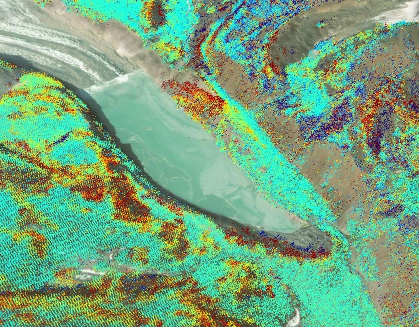
Here are three examples from San Juan Province, Argentina, highlighted by #InSAR. These slow-moving landslides affect large, high-relief mountain slopes and demonstrate the value of regional-scale monitoring for identifying potential geohazards in remote areas where on-the-ground access is limited.

September 22, 2025 at 11:39 AM
Here are three examples from San Juan Province, Argentina, highlighted by #InSAR. These slow-moving landslides affect large, high-relief mountain slopes and demonstrate the value of regional-scale monitoring for identifying potential geohazards in remote areas where on-the-ground access is limited.
But what about the rest of the world? Most regions still don’t have access to this kind of critical information. Too often, where hazards are highest, monitoring is weakest. That gap must close.
September 22, 2025 at 11:39 AM
But what about the rest of the world? Most regions still don’t have access to this kind of critical information. Too often, where hazards are highest, monitoring is weakest. That gap must close.
#InSAR is a proven technology for disaster risk reduction—and it scales. Examples like InSAR Norway insar.ngu.no and the European Ground Motion Service already provide billions of open measurements.

September 22, 2025 at 11:39 AM
#InSAR is a proven technology for disaster risk reduction—and it scales. Examples like InSAR Norway insar.ngu.no and the European Ground Motion Service already provide billions of open measurements.
Why are we organizing this? To push forward a new initiative: making life-saving ground motion data available worldwide, especially where it’s needed most.

September 22, 2025 at 11:39 AM
Why are we organizing this? To push forward a new initiative: making life-saving ground motion data available worldwide, especially where it’s needed most.
Figure taken from www.isro.gov.in/media_isro/p...
www.isro.gov.in
July 30, 2025 at 9:09 AM
Figure taken from www.isro.gov.in/media_isro/p...
And in related weird news, a quick clay slide was triggered near Trondheim, Norway, when a container ship ran aground next to a house! www.nrk.no/trondelag/hu...
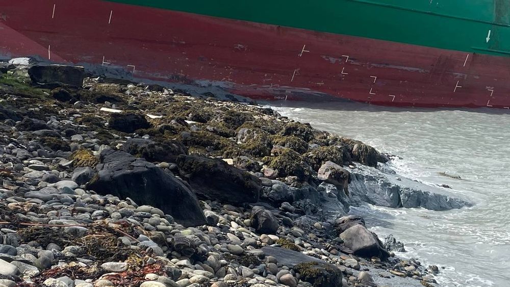
Hus evakueres etter leirras like ved containerskip på Byneset i Trondheim
Like ved stedet lasteskipet traff land har det gått et 100 meter bredt leirskred.
www.nrk.no
May 22, 2025 at 1:15 PM
And in related weird news, a quick clay slide was triggered near Trondheim, Norway, when a container ship ran aground next to a house! www.nrk.no/trondelag/hu...