


@jhiggins24.bsky.social

Reposted

#Melissa has strengthened into a dangerous Category 5 hurricane with catastrophic impacts likely for Jamaica in the next couple of days! 🌀💨🌧️
It is currently moving slowly westward, but is expected to make a sharp turn north heading directly for the western portion of the island.
It is currently moving slowly westward, but is expected to make a sharp turn north heading directly for the western portion of the island.
October 27, 2025 at 3:58 PM
#Melissa has strengthened into a dangerous Category 5 hurricane with catastrophic impacts likely for Jamaica in the next couple of days! 🌀💨🌧️
It is currently moving slowly westward, but is expected to make a sharp turn north heading directly for the western portion of the island.
It is currently moving slowly westward, but is expected to make a sharp turn north heading directly for the western portion of the island.
Reposted
Many of the Cascade Passes have seen their first snow of the season over the past couple of days! This image was taken this morning over Blewett Pass where heavy snowfall rates have forced closures for both directions of travel.

October 13, 2025 at 3:50 PM
Many of the Cascade Passes have seen their first snow of the season over the past couple of days! This image was taken this morning over Blewett Pass where heavy snowfall rates have forced closures for both directions of travel.
Reposted
For the first time in 12 years, a tornado has been rated an EF-5! 🌪️
A wedge tornado dropped near Enderlin, North Dakota on June 20th 2025 that tipped several fully-loaded train cars leading NWS experts to the conclusion that wind speeds exceeded 210 mph from this tornado #ndwx
A wedge tornado dropped near Enderlin, North Dakota on June 20th 2025 that tipped several fully-loaded train cars leading NWS experts to the conclusion that wind speeds exceeded 210 mph from this tornado #ndwx


October 6, 2025 at 6:38 PM
For the first time in 12 years, a tornado has been rated an EF-5! 🌪️
A wedge tornado dropped near Enderlin, North Dakota on June 20th 2025 that tipped several fully-loaded train cars leading NWS experts to the conclusion that wind speeds exceeded 210 mph from this tornado #ndwx
A wedge tornado dropped near Enderlin, North Dakota on June 20th 2025 that tipped several fully-loaded train cars leading NWS experts to the conclusion that wind speeds exceeded 210 mph from this tornado #ndwx
Reposted
#Aurora Borealis was spotted across the northern U.S. states last night, as G3 storm conditions were reached! #spaceweather

October 2, 2025 at 4:34 PM
#Aurora Borealis was spotted across the northern U.S. states last night, as G3 storm conditions were reached! #spaceweather
Reposted
A current look from Tacoma right now as lenticular and asperitas clouds fill the sky as a new system approaches Western Washington! ☁️
Periods of rain and windy conditions are likely through Wednesday, especially near the Pacific coastline 🌧️ 💨 #wawx
Periods of rain and windy conditions are likely through Wednesday, especially near the Pacific coastline 🌧️ 💨 #wawx

September 30, 2025 at 10:44 PM
A current look from Tacoma right now as lenticular and asperitas clouds fill the sky as a new system approaches Western Washington! ☁️
Periods of rain and windy conditions are likely through Wednesday, especially near the Pacific coastline 🌧️ 💨 #wawx
Periods of rain and windy conditions are likely through Wednesday, especially near the Pacific coastline 🌧️ 💨 #wawx
Reposted
Strong westerly winds due to a frontal passage intensified the #LaborMountainFire in Eastern Washington last night, as now it has burned over 25,000 acres! 💨🔥 #wawx

September 26, 2025 at 4:06 PM
Strong westerly winds due to a frontal passage intensified the #LaborMountainFire in Eastern Washington last night, as now it has burned over 25,000 acres! 💨🔥 #wawx
Reposted
All eyes have been focused on the Atlantic off the Southeast U.S. coastline, as a couple tropical systems look to continue developing. 🌀
While Tropical Storm #Humberto does not pose a concern to the U.S. at this time, Invest #94L has a greater chance of landfall as it looks to form closer to shore
While Tropical Storm #Humberto does not pose a concern to the U.S. at this time, Invest #94L has a greater chance of landfall as it looks to form closer to shore


September 25, 2025 at 3:33 PM
Reposted
Thursday will be a huge concern for #fire weather as a mid-level jet will bring strong westerly winds to Eastern WA/OR under low RH values during the afternoon and evening. 🔥
Active fires (particularly the #LaborMountainFire and #LowerSugarloafFire) will likely spread east #wawx #orwx
Active fires (particularly the #LaborMountainFire and #LowerSugarloafFire) will likely spread east #wawx #orwx


September 24, 2025 at 4:33 PM
Thursday will be a huge concern for #fire weather as a mid-level jet will bring strong westerly winds to Eastern WA/OR under low RH values during the afternoon and evening. 🔥
Active fires (particularly the #LaborMountainFire and #LowerSugarloafFire) will likely spread east #wawx #orwx
Active fires (particularly the #LaborMountainFire and #LowerSugarloafFire) will likely spread east #wawx #orwx

Reposted
Sights of fall will be here before you know it, as peak fall color season is only a couple weeks away in the high country of Colorado! 🍁 #cowx

September 16, 2025 at 5:10 PM
Sights of fall will be here before you know it, as peak fall color season is only a couple weeks away in the high country of Colorado! 🍁 #cowx
Reposted
Although the Seattle area is seeing some much needed rainfall today, breezy winds and reduced relative humidity have prompted the NWS to issue a fire weather watch on Sunday. These conditions allow for new fires to spark across the region or even cause existing fires to spread. #wawx #firewx

September 14, 2025 at 8:40 PM
Reposted
Fire season rolls on across Washington as the WA department of natural resources is currently monitoring 19 separate wildfires. A pattern change over the next few weeks should bring some much needed rainfall across western Washington and begin to improve fire conditions across the region. #wawx

September 11, 2025 at 7:23 PM
Fire season rolls on across Washington as the WA department of natural resources is currently monitoring 19 separate wildfires. A pattern change over the next few weeks should bring some much needed rainfall across western Washington and begin to improve fire conditions across the region. #wawx
Reposted
Big changes are coming across the CONUS in the extended forecast, as a preview of fall is likely for the Eastern U.S as a cold front moves in beginning this weekend! 💨🍁
On the western side, monsoon season will make a comeback as well as a prolonged heat wave particularly in the Pacific Northwest ⛈️🔥
On the western side, monsoon season will make a comeback as well as a prolonged heat wave particularly in the Pacific Northwest ⛈️🔥


August 21, 2025 at 3:07 PM
Big changes are coming across the CONUS in the extended forecast, as a preview of fall is likely for the Eastern U.S as a cold front moves in beginning this weekend! 💨🍁
On the western side, monsoon season will make a comeback as well as a prolonged heat wave particularly in the Pacific Northwest ⛈️🔥
On the western side, monsoon season will make a comeback as well as a prolonged heat wave particularly in the Pacific Northwest ⛈️🔥
Reposted
The #BearGulchFire on the Olympic Peninsula in Washington State launched an impressive pyrocumulus cloud yesterday afternoon, as hot and dry weather fueled fire growth by 1200 acres in the last 24 hours! 🔥
This caused smoky skies to occur over the Seattle area during the evening hours. #wawx
This caused smoky skies to occur over the Seattle area during the evening hours. #wawx


August 13, 2025 at 8:14 PM
The #BearGulchFire on the Olympic Peninsula in Washington State launched an impressive pyrocumulus cloud yesterday afternoon, as hot and dry weather fueled fire growth by 1200 acres in the last 24 hours! 🔥
This caused smoky skies to occur over the Seattle area during the evening hours. #wawx
This caused smoky skies to occur over the Seattle area during the evening hours. #wawx
Reposted
A huge pattern change is inbound for the Pacific Northwest over the next few days, as a rare summer atmospheric river will bring cooler and wetter conditions to the region! ☔
Today will be the last day of the heat before well below average temperatures begin on Friday and persist into the weekend.
Today will be the last day of the heat before well below average temperatures begin on Friday and persist into the weekend.


August 12, 2025 at 4:28 PM
A huge pattern change is inbound for the Pacific Northwest over the next few days, as a rare summer atmospheric river will bring cooler and wetter conditions to the region! ☔
Today will be the last day of the heat before well below average temperatures begin on Friday and persist into the weekend.
Today will be the last day of the heat before well below average temperatures begin on Friday and persist into the weekend.
Reposted
Tropical Storm #Erin formed just west of the Cabo Verde Islands today, and is forecasted to eventually strengthen into a hurricane by Wednesday and then a major hurricane by the weekend! 🌀
It is too far out to tell if there is any concern to U.S. Mainland, however trends will be monitored closely.
It is too far out to tell if there is any concern to U.S. Mainland, however trends will be monitored closely.

August 11, 2025 at 10:48 PM
Tropical Storm #Erin formed just west of the Cabo Verde Islands today, and is forecasted to eventually strengthen into a hurricane by Wednesday and then a major hurricane by the weekend! 🌀
It is too far out to tell if there is any concern to U.S. Mainland, however trends will be monitored closely.
It is too far out to tell if there is any concern to U.S. Mainland, however trends will be monitored closely.
Reposted
#Rain is on the way for the Pacific Northwest! A rare summer system will arrive as early as this afternoon and continue until Thursday PM!
While this will help reduce #drought conditions across the region, it will only temporarily relieve it as warm and dry weather looks to return following it.
While this will help reduce #drought conditions across the region, it will only temporarily relieve it as warm and dry weather looks to return following it.
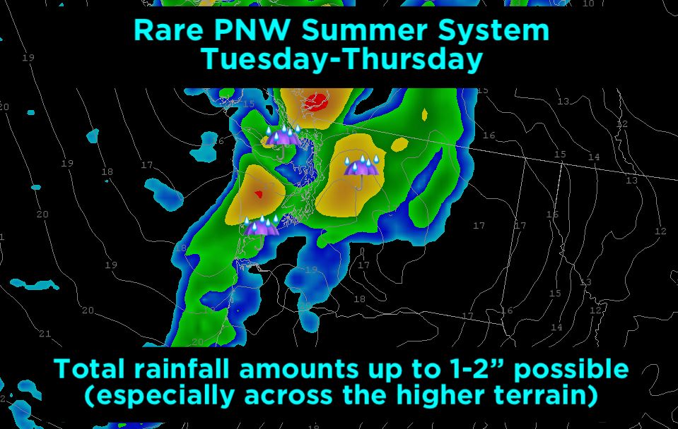

August 5, 2025 at 4:28 PM
Reposted
#Flooding due to heavy rainfall will be on the table for Thursday afternoon and night for portions of the Mid-Atlantic and Northeast. ⛈️
Rain rates up to 1-3"/hr are possible as a very moist atmosphere and favorable upper level dynamics will support high precipitation thunderstorms and showers!
Rain rates up to 1-3"/hr are possible as a very moist atmosphere and favorable upper level dynamics will support high precipitation thunderstorms and showers!


July 30, 2025 at 9:59 PM
#Flooding due to heavy rainfall will be on the table for Thursday afternoon and night for portions of the Mid-Atlantic and Northeast. ⛈️
Rain rates up to 1-3"/hr are possible as a very moist atmosphere and favorable upper level dynamics will support high precipitation thunderstorms and showers!
Rain rates up to 1-3"/hr are possible as a very moist atmosphere and favorable upper level dynamics will support high precipitation thunderstorms and showers!
Reposted
Yesterday, a M8.8 #earthquake occurred off the coast of Russia triggering several tsunamis for coastal areas by the Pacific Ocean! 🌊
Webcam views last night from Crescent City, CA showed a rise in sea level due to a tsunami. #cawx
Webcam views last night from Crescent City, CA showed a rise in sea level due to a tsunami. #cawx


July 30, 2025 at 4:34 PM
Yesterday, a M8.8 #earthquake occurred off the coast of Russia triggering several tsunamis for coastal areas by the Pacific Ocean! 🌊
Webcam views last night from Crescent City, CA showed a rise in sea level due to a tsunami. #cawx
Webcam views last night from Crescent City, CA showed a rise in sea level due to a tsunami. #cawx
Reposted

Reposted
A fantastic #lenticular show by Mount Rainier in Washington State was spotted by many yesterday afternoon, as saucer like clouds took over sky views to the south and west. Did you see it? #wawx

July 27, 2025 at 3:56 PM
A fantastic #lenticular show by Mount Rainier in Washington State was spotted by many yesterday afternoon, as saucer like clouds took over sky views to the south and west. Did you see it? #wawx
Reposted
Taking a look at the latest #drought outlook by the U.S. Drought Monitor, the western half of the U.S. continues to be lacking much needed rainfall.
In particular, a below average monsoon season so far has caused some Southwest areas to experience extreme to exceptional drought conditions! 🏜️
In particular, a below average monsoon season so far has caused some Southwest areas to experience extreme to exceptional drought conditions! 🏜️


July 25, 2025 at 8:58 PM
Taking a look at the latest #drought outlook by the U.S. Drought Monitor, the western half of the U.S. continues to be lacking much needed rainfall.
In particular, a below average monsoon season so far has caused some Southwest areas to experience extreme to exceptional drought conditions! 🏜️
In particular, a below average monsoon season so far has caused some Southwest areas to experience extreme to exceptional drought conditions! 🏜️
Reposted
Electrifying skies were observed last night by the Canadian border in Washington State as a #thunderstorm moved through the area east of Vancouver, British Columbia! ⚡ #wawx #bcwx

July 22, 2025 at 6:07 PM
Electrifying skies were observed last night by the Canadian border in Washington State as a #thunderstorm moved through the area east of Vancouver, British Columbia! ⚡ #wawx #bcwx

