


James Aydelott
@jamesaydelott.bsky.social
He/Him/His
-😍Daddy to 2
-4th Gen Okie
-BS OU Meteorology -MS OkState Emergency Mngmnt
-PhD student OkState Emergency Mngmnt
-Pilot
-Raconteur
-Antagonist
‘Gram: @jamesaydelottwx
Threads: @jamesaydelottwx
-😍Daddy to 2
-4th Gen Okie
-BS OU Meteorology -MS OkState Emergency Mngmnt
-PhD student OkState Emergency Mngmnt
-Pilot
-Raconteur
-Antagonist
‘Gram: @jamesaydelottwx
Threads: @jamesaydelottwx
Tulsa drivers:
Another wreck on the BA Expressway, at I-44, westbound direction.
Tulsa's most poorly designed interchange. Bad idea to have entering traffic, exiting traffic, and a lane ending, all in 1/4 mile. Bad, Bad design that needs to be addressed.
Another wreck on the BA Expressway, at I-44, westbound direction.
Tulsa's most poorly designed interchange. Bad idea to have entering traffic, exiting traffic, and a lane ending, all in 1/4 mile. Bad, Bad design that needs to be addressed.

November 10, 2025 at 11:30 PM
Tulsa drivers:
Another wreck on the BA Expressway, at I-44, westbound direction.
Tulsa's most poorly designed interchange. Bad idea to have entering traffic, exiting traffic, and a lane ending, all in 1/4 mile. Bad, Bad design that needs to be addressed.
Another wreck on the BA Expressway, at I-44, westbound direction.
Tulsa's most poorly designed interchange. Bad idea to have entering traffic, exiting traffic, and a lane ending, all in 1/4 mile. Bad, Bad design that needs to be addressed.
hahahahahahahaha
🐀🌶️
🐀🌶️

November 8, 2025 at 12:31 AM
hahahahahahahaha
🐀🌶️
🐀🌶️
This sunset!! Another incredible one! #okwx #TulsaTime

November 8, 2025 at 12:26 AM
This sunset!! Another incredible one! #okwx #TulsaTime

Tulsa drivers:
Traffic signal at 101st and Memorial in South Tulsa is not working for southbound traffic. Huge backup, all the way back to 169/Mingo Rd.
Traffic signal at 101st and Memorial in South Tulsa is not working for southbound traffic. Huge backup, all the way back to 169/Mingo Rd.

November 6, 2025 at 11:02 PM
Tulsa drivers:
Traffic signal at 101st and Memorial in South Tulsa is not working for southbound traffic. Huge backup, all the way back to 169/Mingo Rd.
Traffic signal at 101st and Memorial in South Tulsa is not working for southbound traffic. Huge backup, all the way back to 169/Mingo Rd.
Weathergami for Tulsa..... Because Summer is often so stagnant, our most common high temp/low temp occurrence in our weather records is 93° and 72°. That combo has happened 79 times! from 1938 to 2023.

November 6, 2025 at 10:33 PM
Weathergami for Tulsa..... Because Summer is often so stagnant, our most common high temp/low temp occurrence in our weather records is 93° and 72°. That combo has happened 79 times! from 1938 to 2023.
148pm—
Meteorologists at the @nwsspc are closely monitoring areas along and SE of I-44 for a tornado watch. Conditions still favorable for severe storms and possibly tornado warnings #okwx
Meteorologists at the @nwsspc are closely monitoring areas along and SE of I-44 for a tornado watch. Conditions still favorable for severe storms and possibly tornado warnings #okwx

September 23, 2025 at 6:48 PM
148pm—
Meteorologists at the @nwsspc are closely monitoring areas along and SE of I-44 for a tornado watch. Conditions still favorable for severe storms and possibly tornado warnings #okwx
Meteorologists at the @nwsspc are closely monitoring areas along and SE of I-44 for a tornado watch. Conditions still favorable for severe storms and possibly tornado warnings #okwx
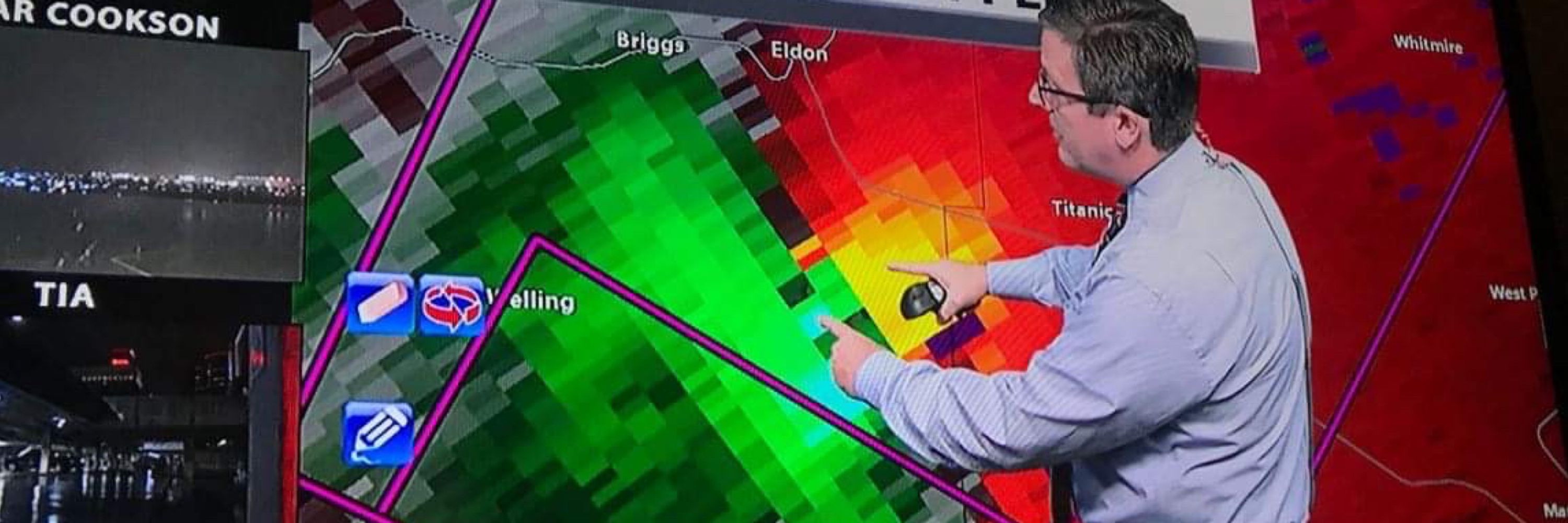
1145am—severe weather update
Upgrade to severe weather and tornado risk. Both have increased.
Impact: hail to 2”, damaging wind, tornadoes possible
Location: Mainly SE of I-44
Timing: developing as early as 3pm near I-44, moving east and into Arkansas by 9pm #okwx
Upgrade to severe weather and tornado risk. Both have increased.
Impact: hail to 2”, damaging wind, tornadoes possible
Location: Mainly SE of I-44
Timing: developing as early as 3pm near I-44, moving east and into Arkansas by 9pm #okwx


September 23, 2025 at 4:47 PM
1145am—severe weather update
Upgrade to severe weather and tornado risk. Both have increased.
Impact: hail to 2”, damaging wind, tornadoes possible
Location: Mainly SE of I-44
Timing: developing as early as 3pm near I-44, moving east and into Arkansas by 9pm #okwx
Upgrade to severe weather and tornado risk. Both have increased.
Impact: hail to 2”, damaging wind, tornadoes possible
Location: Mainly SE of I-44
Timing: developing as early as 3pm near I-44, moving east and into Arkansas by 9pm #okwx

700pm—Radar update
Downpours continue over parts of Pittsburg County, close to Hartshorne and Haileyville. Respect the lightning threat #okwx.
Downpours continue over parts of Pittsburg County, close to Hartshorne and Haileyville. Respect the lightning threat #okwx.
September 19, 2025 at 12:02 AM
700pm—Radar update
Downpours continue over parts of Pittsburg County, close to Hartshorne and Haileyville. Respect the lightning threat #okwx.
Downpours continue over parts of Pittsburg County, close to Hartshorne and Haileyville. Respect the lightning threat #okwx.
September 18, 2025 at 6:28 PM

BARELY MOVING severe storm just north of Fairland in Ottawa County. Maybe an excruciatingly slow drift to the south.... gusty wind and some hail possible on OK-125. #okwx

September 16, 2025 at 10:35 PM
BARELY MOVING severe storm just north of Fairland in Ottawa County. Maybe an excruciatingly slow drift to the south.... gusty wind and some hail possible on OK-125. #okwx
406pm—-Radar update
Isolated storms have bubbled up, mainly SE of Tulsa, but there is one little puffball north of Pawhuska.
Movement is a slow drift westward.
Respect the lightning threat. #okwx
Isolated storms have bubbled up, mainly SE of Tulsa, but there is one little puffball north of Pawhuska.
Movement is a slow drift westward.
Respect the lightning threat. #okwx
September 16, 2025 at 9:11 PM
406pm—-Radar update
Isolated storms have bubbled up, mainly SE of Tulsa, but there is one little puffball north of Pawhuska.
Movement is a slow drift westward.
Respect the lightning threat. #okwx
Isolated storms have bubbled up, mainly SE of Tulsa, but there is one little puffball north of Pawhuska.
Movement is a slow drift westward.
Respect the lightning threat. #okwx
Smoke from Canadian wildfires, mostly in British Columbia, is rolling into our Oklahoma sky. If it doesn't get too thick, it should be a pretty orange/coral sunset! #okwx


September 4, 2025 at 10:15 PM
Smoke from Canadian wildfires, mostly in British Columbia, is rolling into our Oklahoma sky. If it doesn't get too thick, it should be a pretty orange/coral sunset! #okwx
625pm—-
Flash Flood Warning for East Tulsa, Broken Arrow, Leonard, Bixby and in NE Okmulgee County.
Be very alert for street flooding!
This is a radar rainfall estimation showing where the heaviest rain has fallen. #okwx
Flash Flood Warning for East Tulsa, Broken Arrow, Leonard, Bixby and in NE Okmulgee County.
Be very alert for street flooding!
This is a radar rainfall estimation showing where the heaviest rain has fallen. #okwx

August 11, 2025 at 11:26 PM
625pm—-
Flash Flood Warning for East Tulsa, Broken Arrow, Leonard, Bixby and in NE Okmulgee County.
Be very alert for street flooding!
This is a radar rainfall estimation showing where the heaviest rain has fallen. #okwx
Flash Flood Warning for East Tulsa, Broken Arrow, Leonard, Bixby and in NE Okmulgee County.
Be very alert for street flooding!
This is a radar rainfall estimation showing where the heaviest rain has fallen. #okwx


July 27, 2025 at 12:38 PM
Please share…
Heat exhaustion is sneaky. Take steps to lower your risk, BEFORE you see signs of it. EVERYONE is at risk.
The heat and humidity will be dangerously high from midday to late afternoon this week.
Heat Index values may top 110° #okwx
Heat exhaustion is sneaky. Take steps to lower your risk, BEFORE you see signs of it. EVERYONE is at risk.
The heat and humidity will be dangerously high from midday to late afternoon this week.
Heat Index values may top 110° #okwx


July 21, 2025 at 1:25 PM
Please share…
Heat exhaustion is sneaky. Take steps to lower your risk, BEFORE you see signs of it. EVERYONE is at risk.
The heat and humidity will be dangerously high from midday to late afternoon this week.
Heat Index values may top 110° #okwx
Heat exhaustion is sneaky. Take steps to lower your risk, BEFORE you see signs of it. EVERYONE is at risk.
The heat and humidity will be dangerously high from midday to late afternoon this week.
Heat Index values may top 110° #okwx
Tulsa friends!!
Are your car windows up?
The one pop up storm in all of Eastern Oklahoma is moving in.
Not severe.
Are your car windows up?
The one pop up storm in all of Eastern Oklahoma is moving in.
Not severe.
July 17, 2025 at 10:15 PM
Tulsa friends!!
Are your car windows up?
The one pop up storm in all of Eastern Oklahoma is moving in.
Not severe.
Are your car windows up?
The one pop up storm in all of Eastern Oklahoma is moving in.
Not severe.
1241pm—
A couple of pop up storms bubbling up over Tulsa. Respect the lightning threat, and make sure your car windows are up.
A couple of pop up storms bubbling up over Tulsa. Respect the lightning threat, and make sure your car windows are up.
July 14, 2025 at 5:43 PM
1241pm—
A couple of pop up storms bubbling up over Tulsa. Respect the lightning threat, and make sure your car windows are up.
A couple of pop up storms bubbling up over Tulsa. Respect the lightning threat, and make sure your car windows are up.
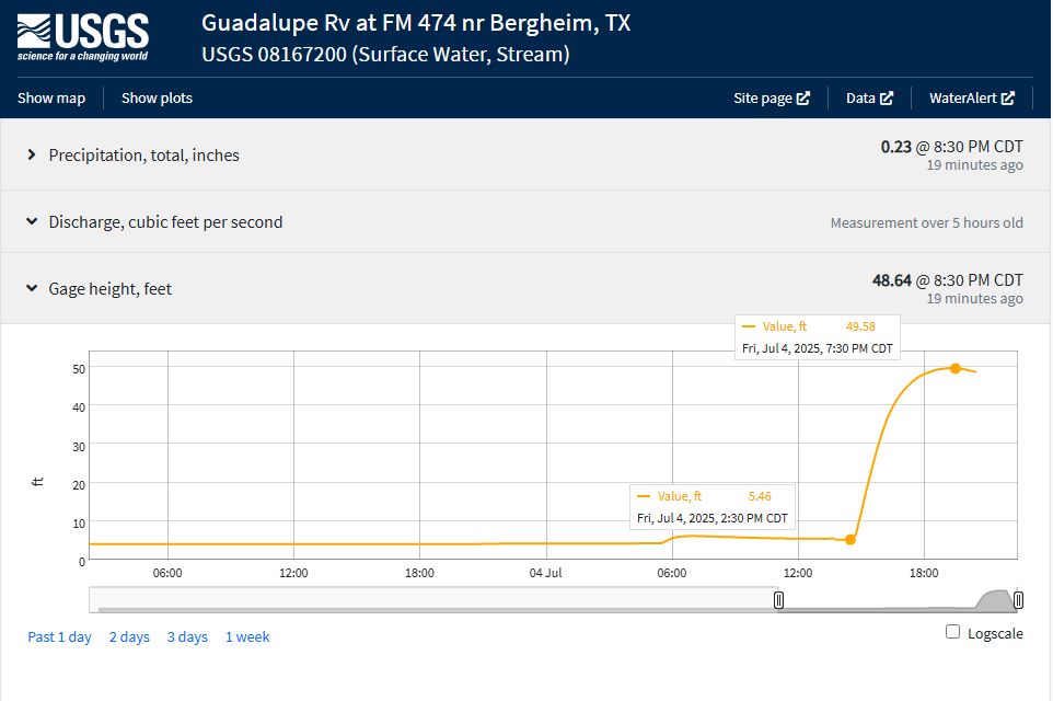
The surge of floodwater has passed the USGS river gauge along the Guadalupe River near Bergheim, TX, NW of San Antonio.
The river went from just over 5 feet to more than 49 feet in five hours. 44 FOOT WATER RISE.
The river went from just over 5 feet to more than 49 feet in five hours. 44 FOOT WATER RISE.
July 5, 2025 at 2:06 AM
The surge of floodwater has passed the USGS river gauge along the Guadalupe River near Bergheim, TX, NW of San Antonio.
The river went from just over 5 feet to more than 49 feet in five hours. 44 FOOT WATER RISE.
The river went from just over 5 feet to more than 49 feet in five hours. 44 FOOT WATER RISE.
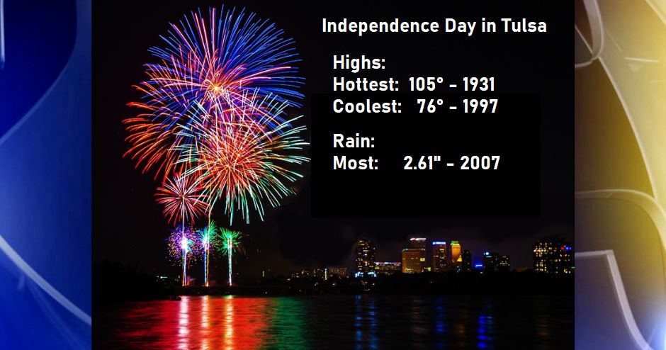
Independence Day in Tulsa.
Records at Tulsa International Airport started in 1931
We've had measurable rain on about 1/4th of our July 4ths.
The coldest ever was a low of 57° in 1940
Records at Tulsa International Airport started in 1931
We've had measurable rain on about 1/4th of our July 4ths.
The coldest ever was a low of 57° in 1940
July 4, 2025 at 11:36 PM
Independence Day in Tulsa.
Records at Tulsa International Airport started in 1931
We've had measurable rain on about 1/4th of our July 4ths.
The coldest ever was a low of 57° in 1940
Records at Tulsa International Airport started in 1931
We've had measurable rain on about 1/4th of our July 4ths.
The coldest ever was a low of 57° in 1940
As the surge of floodwater moves down the Guadalupe River NW of San Antonio, near Bergheim, the river rose close to 28 FEET in two hours this afternoon.

July 4, 2025 at 9:44 PM
As the surge of floodwater moves down the Guadalupe River NW of San Antonio, near Bergheim, the river rose close to 28 FEET in two hours this afternoon.